
| CLIFF HATFIELD MEMORIAL CALIPATRIA CA |
| |
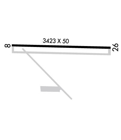
| Lat: N 3307.9 Long: W 11531.3 Elev: -182 Var: -13 Longest Runway: 3423 | ||
| CTAF: 122.9 | ||
| ||||||||||||||||||||||||||||||||
| ||||||||||||||||||||||||||||||||
| Rwy | Rwy | |||||||
| 3423x50 | 3303' | 3423x50 | 3194' | |||||
| Runway ID | Single Wheel | Double Wheel | Double Tandem Wheel | Dual Double Wheel |
| 08/26 | 12,000 | N/A | N/A | N/A |
| These numbers are Advisory and are not limits. The Airport Manager should have more accurate Weight Limits | ||||
 Airport Diagram might not be current. | |
| Facility Name: | CLIFF HATFIELD MEML |
| City Name: | CALIPATRIA |
| County: | IMPERIAL |
| State abbrev: | CA |
| State Name: | CALIFORNIA |
| Ownership: | PUBLICLY OWNED |
| Use: | OPEN TO THE PUBLIC |
| Owner's Name: | CITY OF CALIPATRIA |
| Address: | 125 N. PARK AVE |
| CALIPATRIA, CA 92233 | |
| Owner's Phone: | 760-348-4141 |
| Manager's Name: | JESSE LLANAS |
| Address: | 125 N. PARK AVE. |
| CALIPATRIA, CA 92233 | |
| Phone: | 760-348-4144; FIRE DEPT OFC IN CALIPATRIA. CELL PHONE 760-791-0296. |
| FAA Region: | WESTERN-PACIFIC |
| FAA Field Office: | LAX |
| Date | Sunrise | Sunset |
|---|---|---|
| 09/24/21 Friday | 6:31 | 18:36 |
| 09/25/21 Saturday | 6:32 | 18:35 |
| 09/26/21 Sunday | 6:33 | 18:34 |
| 09/27/21 Monday | 6:33 | 18:32 |
| 09/28/21 Tuesday | 6:34 | 18:31 |
| 09/29/21 Wednesday | 6:35 | 18:29 |
| 09/30/21 Thursday | 6:35 | 18:28 |
| 10/01/21 Friday | 6:36 | 18:27 |
| 10/02/21 Saturday | 6:37 | 18:25 |
| 10/03/21 Sunday | 6:38 | 18:24 |
| 10/04/21 Monday | 6:38 | 18:23 |
| 10/05/21 Tuesday | 6:39 | 18:22 |
| 10/06/21 Wednesday | 6:40 | 18:20 |
| 10/07/21 Thursday | 6:40 | 18:19 |
| Airport Attendance Schedule | UNATTENDED |
| Airport Status | OPERATIONAL (This Status can change at any time - please check NOTAMS) |
| Airport Lighting Schedule | |
| Airport Storage Available | NONE |
| Extra Services Available | NONE |
| Wind Indicator | YES - (unlit) |
| Control Tower | NO |
| CTAF Frequency | 122.900 |
| Unicom Frequency | |
| Rotating Beacon Color | |
| Segmented Circle | YES |
| Landing Fee | NO |
| Airport Inspected | STATE - performed by STATE AERONAUTICAL PERSONNEL |
| Inspection Date | 02/26/2020 |
| Type of Fuel Available | None |
| Airframe Repair Service | NONE |
| Power Plant Repair Service | NONE |
| Latitude | N3307.9 |
| Longitude | W11531.3 (ESTIMATED) |
| Arpt Elevation | -182ft (SURVEYED) |
| Magnetic Variation | 13E |
| 1 miles NW | of CALIPATRIA |
| Traffic Pattern Altitude | 800 |
| Sectional Chart | LOS ANGELES |
| Operations (Reported) | Yearly | Avg. Daily |
|---|---|---|
| General Aviation Transient | 1500 | 4 |
| General Aviation Local | 0 | 0 |
| Air Taxi | 0 | 0 |
| Commerical | 0 | 0 |
| Commuter | 0 | 0 |
| Military | 0 | 0 |
| Aircraft based on Field | |
|---|---|
| General Aviation Singles | 0 |
| General Aviation Multi | 0 |
| Jet Aircraft | 0 |
| General Aviation Helicopters | 0 |
| Military Aircraft | 0 |
| Gliders | 0 |
| Ultralights | 0 |
| FSS on field | NO |
| FSS tie-in | SAN DIEGO |
| FSS Phone | 1-800-WX-BRIEF |
| Who issues Notams | SAN |
| Notam D service at airport | YES |
| ARTCC Name | LOS ANGELES |
| Airport Certification | |
| Aircraft Rescue & Firefighting Index | None |
| Airport of Entry | No |
| Custom Landing Rights | No |
| Joint Civil/Military | No |
| Military Landing rights | No |
| THIS AIRPORT HAS BEEN SURVEYED BY THE NATIONAL GEODETIC SURVEY. |
| PARALLEL TWY CLOSED INDEFLY. |
| OBSTN PART 77 +184' LGTD FLAG POLE 800' SE OF ARPT. |
| FOR CD CTC LOS ANGELES ARTCC AT 661-575-2079. |
Airport Communications & Frequencies:
| |||||||
| Runway: 08 | Runway: 26 | ||
| Mag heading: | 78° | Mag heading: | 258° |
| Rwy Slope: | .09% Up | Rwy Slope: | -.09% Down |
| Approach: | Approach: | ||
| Pattern: | Left Traffic | Pattern: | Right Traffic |
| Markings: | NONPRECISION INSTRUMENT | Markings: | NONPRECISION INSTRUMENT |
| Marking Condition: | GOOD | Marking Condition: | GOOD |
| Arresting Dev: | Arresting Dev: | ||
| Lat & Long: | N3307.9 W11531.6 | Lat. & Long.: | N3307.9 W11530.9 |
| Elev: | -184.8 ft. MSL | Elev: | -181.8 ft. MSL |
| TCH: | TCH: | ||
| Visual Glide Path: | Visual Glide Path: | ||
| Displaced Threshold: | 120 feet | Displaced Threshold: | 229 feet |
| Touchdown Zone: | YES | Touchdown Zone: | YES |
| Touchdown Elev.: | -182.0 feet | Touchdown Elev.: | -181.8 feet |
| Visual Glide Slope: | Visual Glide Slope: | ||
| RVR Equipment: | RVR Equipment: | ||
| RVV Equipment: | NO | RVV Equipment: | NO |
| Approach Lights: | Approach Lights: | ||
| REIL: | NO | REIL: | NO |
| Centerline Lights: | NO | Centerline Lights: | NO |
| Touchdown lights: | NO | Touchdown lights: | NO |
| Runway Category: | Runway with a Non-precision Approach | Runway Category: | Runway with a Visual Approach |
| Declared Distances: | Declared Distances: | ||
| Obstructions: | ROAD | Obstructions: | ROAD |
| Marked: | NOT Marked/Lighted | Marked: | NOT Marked/Lighted |
| Clearance slope: | APPROACH SLOPE 21:1 BASED ON DSPLCD THR | Clearance slope: | 17:1 |
| Obstruction height: | 15 feet AGL | Obstruction height: | 15 feet AGL |
| Dist. from runway: | 200 feet | Dist. from runway: | 460 feet |
| Centerline offset: | Centerline offset: | ||
| Comments: | RWY 08 +3 FT FENCE AT 190 FT. | Comments: | RWY 26 +3 FT FENCE 150 FT RIGHT, FM 260-500 FT FM THLD. |
Thanks for using FltPlan.com
all rights reserved © 1999-2021 by Flight Plan LLC
