
| WILLIAM R FAIRCHILD INTL PORT ANGELES WA |
| |
| Lat: N 4807.2 Long: W 12330.0 Elev: 291 Var: -16 Longest Runway: 6347 | ||
| Clr Del: 124.15 AWOS: 135.17 CTAF: 122.97 | ||
| ||||||||||||||||||||||||||||||||||||||||||||
| ||||||||||||||||||||||||||||||||||||||||||||
| ||||||||||||||||||||||||||||||||||||||||||||
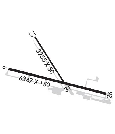
| Rwy | Rwy | |||||||
| 6347x150 | 6347' | 108.90 - 088° | 6347x150 | 4993' | ||||
| 3255x50 | 3255' | 3255x50 | 3255' | |||||
| Runway ID | Single Wheel | Double Wheel | Double Tandem Wheel | Dual Double Wheel |
| 08/26 | 55,000 | 66,000 | 115,000 | N/A |
| 13/31 | 30,000 | N/A | N/A | N/A |
| These numbers are Advisory and are not limits. The Airport Manager should have more accurate Weight Limits | ||||
 Airport Diagram might not be current. | |
| Facility Name: | WILLIAM R FAIRCHILD INTL |
| City Name: | PORT ANGELES |
| County: | CLALLAM |
| State abbrev: | WA |
| State Name: | WASHINGTON |
| Ownership: | PUBLICLY OWNED |
| Use: | OPEN TO THE PUBLIC |
| Owner's Name: | PORT OF PORT ANGELES |
| Address: | PO BOX 1350 |
| PORT ANGELES, WA 98362 | |
| Owner's Phone: | 360-457-8527 |
| Manager's Name: | DANIEL E. GASE |
| Address: | PO BOX 1350, 338 WEST FIRST STREET |
| PORT ANGELES, WA 98362 | |
| Phone: | (360) 417-3376 |
| FAA Region: | NORTHWEST MOUNTAIN |
| FAA Field Office: | SEA |
| Date | Sunrise | Sunset |
|---|---|---|
| 09/24/21 Friday | 7:03 | 19:08 |
| 09/25/21 Saturday | 7:05 | 19:06 |
| 09/26/21 Sunday | 7:06 | 19:04 |
| 09/27/21 Monday | 7:07 | 19:02 |
| 09/28/21 Tuesday | 7:09 | 19:00 |
| 09/29/21 Wednesday | 7:10 | 18:58 |
| 09/30/21 Thursday | 7:12 | 18:55 |
| 10/01/21 Friday | 7:13 | 18:53 |
| 10/02/21 Saturday | 7:14 | 18:51 |
| 10/03/21 Sunday | 7:16 | 18:49 |
| 10/04/21 Monday | 7:17 | 18:47 |
| 10/05/21 Tuesday | 7:19 | 18:45 |
| 10/06/21 Wednesday | 7:20 | 18:43 |
| 10/07/21 Thursday | 7:22 | 18:41 |
| Airport Attendance Schedule | 7 Days A Week 0900-1930 |
| Airport Status | OPERATIONAL (This Status can change at any time - please check NOTAMS) |
| Airport Lighting Schedule | ACTVT MALSR RWY 08; MIRL RWY 08/26 - CTAF. |
| Airport Storage Available | Tie Downs |
| Extra Services Available | Air Freight, Cargo Handling, Charter, Flight Instruction, Aircraft Rental |
| Wind Indicator | YES - (lighted) |
| Control Tower | NO |
| CTAF Frequency | 122.975 |
| Unicom Frequency | 122.975 |
| Rotating Beacon Color | CLEAR-GREEN (Light Land Airport) |
| Segmented Circle | YES |
| Landing Fee | NO |
| Airport Inspected | FEDERAL - performed by STATE AERONAUTICAL PERSONNEL |
| Inspection Date | 08/21/2019 |
| Type of Fuel Available | Grade 100LL, JET A (freeze point -40C); -10FOR AFT HRS JET A CALL 360-452-6226. |
| Airframe Repair Service | MAJOR |
| Power Plant Repair Service | MAJOR |
| Latitude | N4807.2 |
| Longitude | W12330.0 (ESTIMATED) |
| Arpt Elevation | 291ft (SURVEYED) |
| Magnetic Variation | 16E |
| 3 miles NW | of PORT ANGELES |
| Traffic Pattern Altitude | |
| Sectional Chart | SEATTLE |
| Operations (Reported) | Yearly | Avg. Daily |
|---|---|---|
| General Aviation Transient | 9200 | 25 |
| General Aviation Local | 10800 | 30 |
| Air Taxi | 4958 | 14 |
| Commerical | 0 | 0 |
| Commuter | 0 | 0 |
| Military | 200 | 1 |
| Aircraft based on Field | |
|---|---|
| General Aviation Singles | 64 |
| General Aviation Multi | 1 |
| Jet Aircraft | 1 |
| General Aviation Helicopters | 2 |
| Military Aircraft | 0 |
| Gliders | 0 |
| Ultralights | 0 |
| FSS on field | NO |
| FSS tie-in | SEATTLE |
| FSS Phone | 1-800-WX-BRIEF |
| Who issues Notams | CLM |
| Notam D service at airport | YES |
| ARTCC Name | SEATTLE |
| Airport Certification | |
| Aircraft Rescue & Firefighting Index | None |
| Airport of Entry | No |
| Custom Landing Rights | YES |
| Joint Civil/Military | No |
| Military Landing rights | YES |
| NATIONAL PLAN OF INTEGRATED AIRPORT SYSTEMS (NPIAS) |
| GRANT AGREEMENTS UNDER FAAP/ADAP/AIP |
| SURPLUS PROPERTY AGREEMENT UNDER PUBLIC LAW 289 |
| ASSURANCES PURSUANT TO TITLE VI, CIVIL RIGHTS ACT OF 1964 |
| AGREEMENT UNDER DLAND OR DCLA HAS EXPIRED. |
| RY 13/31 CLSD DUSK TO DAWN. |
| FOR CD IF UNA TO CTC ON FSS FREQ, CTC WHIDBEY APCH AT 360-257-3310. |
Airport Communications & Frequencies:
| |||||||||||||||||||
| Runway: 08 | Runway: 26 | ||
| Mag heading: | 89° | Mag heading: | 269° |
| Rwy Slope: | .12% Up | Rwy Slope: | -.12% Down |
| Approach: | ILS | Approach: | |
| Pattern: | Left Traffic | Pattern: | Right Traffic |
| Markings: | PRECISION INSTRUMENT | Markings: | NONPRECISION INSTRUMENT |
| Marking Condition: | FAIR | Marking Condition: | FAIR |
| Arresting Dev: | Arresting Dev: | ||
| Lat & Long: | N4807.3 W12330.7 | Lat. & Long.: | N4807.0 W12329.2 |
| Elev: | 283.8 ft. MSL | Elev: | 291.3 ft. MSL |
| TCH: | 50 ft. AGL | TCH: | 50 ft. AGL |
| Visual Glide Path: | 3.00 degrees | Visual Glide Path: | 3.70 degrees |
| Displaced Threshold: | No | Displaced Threshold: | 1354 feet |
| Touchdown Zone: | YES | Touchdown Zone: | YES |
| Touchdown Elev.: | 284.5 feet | Touchdown Elev.: | 282.3 feet |
| Visual Glide Slope: | 4-BOX VASI ON LEFT SIDE OF RUNWAY | Visual Glide Slope: | 4-Light PAPI on LEFT side of Runway; UNUSBL BYD 8 DEGS L OF CNTRLN. |
| RVR Equipment: | RVR Equipment: | ||
| RVV Equipment: | NO | RVV Equipment: | NO |
| Approach Lights: | MALSR - 1,400 foot medium intensity approach lighting system with runway alignment indicator lights | Approach Lights: | |
| REIL: | NO | REIL: | YES |
| Centerline Lights: | NO | Centerline Lights: | NO |
| Touchdown lights: | NO | Touchdown lights: | NO |
| Runway Category: | Precision Instrument Runway | Runway Category: | Runway with a Non-precision Approach having visibility minimums greater than 3/4 mile |
| Declared Distances: | Declared Distances: | ||
| Obstructions: | TREES | Obstructions: | ANT |
| Marked: | NOT Marked/Lighted | Marked: | NOT Marked/Lighted |
| Clearance slope: | 27:1 | Clearance slope: | 15:1; +35' BLDG; DIST 520'; 500' LEFT; 15:1 BASED ON DSPLCD THR. |
| Obstruction height: | 111 feet AGL | Obstruction height: | 19 feet AGL |
| Dist. from runway: | 3200 feet | Dist. from runway: | 300 feet |
| Centerline offset: | Centerline offset: | 300 feet right of centerline | |
| Comments: | Comments: |
| Runway: 13 | Runway: 31 | ||
| Mag heading: | 132° | Mag heading: | 312° |
| Rwy Slope: | 1.35% Up | Rwy Slope: | -1.35% Down |
| Approach: | Approach: | ||
| Pattern: | Left Traffic | Pattern: | Right Traffic |
| Markings: | BASIC | Markings: | BASIC |
| Marking Condition: | GOOD | Marking Condition: | GOOD |
| Arresting Dev: | Arresting Dev: | ||
| Lat & Long: | N4807.6 W12330.3 | Lat. & Long.: | N4807.1 W12329.9 |
| Elev: | 227.2 ft. MSL | Elev: | 271.3 ft. MSL |
| TCH: | TCH: | ||
| Visual Glide Path: | Visual Glide Path: | ||
| Displaced Threshold: | No | Displaced Threshold: | No |
| Touchdown Zone: | YES | Touchdown Zone: | YES |
| Touchdown Elev.: | 268.7 feet | Touchdown Elev.: | 271.3 feet |
| Visual Glide Slope: | Visual Glide Slope: | ||
| RVR Equipment: | RVR Equipment: | ||
| RVV Equipment: | NO | RVV Equipment: | NO |
| Approach Lights: | Approach Lights: | ||
| REIL: | NO | REIL: | NO |
| Centerline Lights: | NO | Centerline Lights: | NO |
| Touchdown lights: | NO | Touchdown lights: | NO |
| Runway Category: | Runway with a Visual Approach | Runway Category: | Runway with a Visual Approach |
| Declared Distances: | Declared Distances: | ||
| Obstructions: | TREES | Obstructions: | TREES |
| Marked: | NOT Marked/Lighted | Marked: | NOT Marked/Lighted |
| Clearance slope: | 11:1 | Clearance slope: | 23:1 |
| Obstruction height: | 27 feet AGL | Obstruction height: | 37 feet AGL |
| Dist. from runway: | 522 feet | Dist. from runway: | 1080 feet |
| Centerline offset: | Centerline offset: | ||
| Comments: | Comments: |
Thanks for using FltPlan.com
all rights reserved © 1999-2021 by Flight Plan LLC
