
| CLINTONVILLE MUNI CLINTONVILLE WI |
| |
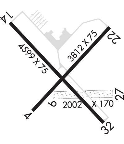
| Lat: N 4436.8 Long: W 08843.9 Elev: 826 Var: +02 Longest Runway: 4599 | ||
| AWOS: 120.67 CTAF: 122.8 | ||
| ||||||
| ||||||
|
| Rwy | Rwy | |||||||
| 3812x75 | 3812' | 3812x75 | 3812' | |||||
| 2002x170 | 2002' | 2002x170 | 2002' | |||||
| 4599x75 | 4599' | 4599x75 | 4599' | |||||
| Runway ID | Single Wheel | Double Wheel | Double Tandem Wheel | Dual Double Wheel |
| 04/22 | 40,000 | 70,000 | N/A | N/A |
| 09/27 | N/A | N/A | N/A | N/A |
| 14/32 | 30,000 | 55,000 | N/A | N/A |
| These numbers are Advisory and are not limits. The Airport Manager should have more accurate Weight Limits | ||||
 Airport Diagram might not be current. | |
| Facility Name: | CLINTONVILLE MUNI |
| City Name: | CLINTONVILLE |
| County: | WAUPACA |
| State abbrev: | WI |
| State Name: | WISCONSIN |
| Ownership: | PUBLICLY OWNED |
| Use: | OPEN TO THE PUBLIC |
| Owner's Name: | CITY OF CLINTONVILLE |
| Address: | CITY HALL; 50 TENTH STREET |
| CLINTONVILLE, WI 54929 | |
| Owner's Phone: | 715-823-7600 |
| Manager's Name: | CAZ MUSKE |
| Address: | 50 10TH ST |
| CLINTONVILLE, WI 54929 | |
| Phone: | (715) 250-0220 |
| FAA Region: | GREAT LAKES |
| FAA Field Office: | CHI |
| Date | Sunrise | Sunset |
|---|---|---|
| 09/24/21 Friday | 6:44 | 18:49 |
| 09/25/21 Saturday | 6:45 | 18:47 |
| 09/26/21 Sunday | 6:46 | 18:45 |
| 09/27/21 Monday | 6:48 | 18:43 |
| 09/28/21 Tuesday | 6:49 | 18:42 |
| 09/29/21 Wednesday | 6:50 | 18:40 |
| 09/30/21 Thursday | 6:51 | 18:38 |
| 10/01/21 Friday | 6:52 | 18:36 |
| 10/02/21 Saturday | 6:54 | 18:34 |
| 10/03/21 Sunday | 6:55 | 18:32 |
| 10/04/21 Monday | 6:56 | 18:30 |
| 10/05/21 Tuesday | 6:57 | 18:29 |
| 10/06/21 Wednesday | 6:59 | 18:27 |
| 10/07/21 Thursday | 7:00 | 18:25 |
| Airport Attendance Schedule | MON-FRI 0800-1700 |
| Airport Status | OPERATIONAL (This Status can change at any time - please check NOTAMS) |
| Airport Lighting Schedule | ACTVT REIL RWY 32; PAPI RWY 32; MIRL RWY 4/22 & 14/32 - CTAF. |
| Airport Storage Available | Tie Downs, Hanger |
| Extra Services Available | Avionics, Charter, Flight Instruction, Aircraft Rental |
| Wind Indicator | YES - (lighted) |
| Control Tower | NO |
| CTAF Frequency | 122.800 |
| Unicom Frequency | 122.800 |
| Rotating Beacon Color | CLEAR-GREEN (Light Land Airport) |
| Segmented Circle | NO |
| Landing Fee | NO |
| Airport Inspected | STATE - performed by STATE AERONAUTICAL PERSONNEL |
| Inspection Date | 06/24/2020 |
| Type of Fuel Available | Grade 100LL, JET A (freeze point -40C); -1024 HR SELF SERVICE |
| Airframe Repair Service | MAJOR |
| Power Plant Repair Service | MAJOR |
| Latitude | N4436.8 |
| Longitude | W08843.9 (ESTIMATED) |
| Arpt Elevation | 825ft (SURVEYED) |
| Magnetic Variation | 02W |
| 1 miles SE | of CLINTONVILLE |
| Traffic Pattern Altitude | |
| Sectional Chart | GREEN BAY |
| Operations (Reported) | Yearly | Avg. Daily |
|---|---|---|
| General Aviation Transient | 5730 | 16 |
| General Aviation Local | 5000 | 14 |
| Air Taxi | 750 | 2 |
| Commerical | 0 | 0 |
| Commuter | 0 | 0 |
| Military | 20 | 0 |
| Aircraft based on Field | |
|---|---|
| General Aviation Singles | 20 |
| General Aviation Multi | 1 |
| Jet Aircraft | 0 |
| General Aviation Helicopters | 0 |
| Military Aircraft | 0 |
| Gliders | 0 |
| Ultralights | 0 |
| FSS on field | NO |
| FSS tie-in | GREEN BAY |
| FSS Phone | 1-800-WX-BRIEF |
| Who issues Notams | CLI |
| Notam D service at airport | YES |
| ARTCC Name | MINNEAPOLIS |
| Airport Certification | |
| Aircraft Rescue & Firefighting Index | None |
| Airport of Entry | No |
| Custom Landing Rights | No |
| Joint Civil/Military | No |
| Military Landing rights | YES |
| NATIONAL PLAN OF INTEGRATED AIRPORT SYSTEMS (NPIAS) |
| GRANT AGREEMENTS UNDER FAAP/ADAP/AIP |
| ASSURANCES PURSUANT TO TITLE VI, CIVIL RIGHTS ACT OF 1964 |
| DEER, FOX & BIRDS ON & INVOF ARPT. |
| FOR CD CTC GREEN BAY APCH AT 920-431-5741. WHEN APCH CLSD, CTC MINNEAPOLIS ARTCC AT 651-463-5588. |
| RWY 09/2 7 CLSD FM 1 DEC TO 15 APR; TO CONFIRM RWY COND OTR TIMES CTC AMGR. |
Airport Communications & Frequencies:
| |||||||||||||||||
| Runway: 04 | Runway: 22 | ||
| Mag heading: | 45° | Mag heading: | 225° |
| Rwy Slope: | -.40% Down | Rwy Slope: | .40% Up |
| Approach: | Approach: | ||
| Pattern: | Left Traffic | Pattern: | Left Traffic |
| Markings: | NONPRECISION INSTRUMENT | Markings: | NONPRECISION INSTRUMENT |
| Marking Condition: | GOOD | Marking Condition: | GOOD |
| Arresting Dev: | Arresting Dev: | ||
| Lat & Long: | N4436.6 W08844.1 | Lat. & Long.: | N4437.1 W08843.5 |
| Elev: | 825.9 ft. MSL | Elev: | 810.6 ft. MSL |
| TCH: | TCH: | ||
| Visual Glide Path: | Visual Glide Path: | ||
| Displaced Threshold: | No | Displaced Threshold: | No |
| Touchdown Zone: | YES | Touchdown Zone: | YES |
| Touchdown Elev.: | 825.9 feet | Touchdown Elev.: | 820.8 feet |
| Visual Glide Slope: | Visual Glide Slope: | ||
| RVR Equipment: | RVR Equipment: | ||
| RVV Equipment: | NO | RVV Equipment: | NO |
| Approach Lights: | Approach Lights: | ||
| REIL: | NO | REIL: | NO |
| Centerline Lights: | NO | Centerline Lights: | NO |
| Touchdown lights: | NO | Touchdown lights: | NO |
| Runway Category: | Runway with a Non-precision Approach | Runway Category: | Runway with a Non-precision Approach |
| Declared Distances: | Declared Distances: |
| Runway: 09 | Runway: 27 | ||
| Mag heading: | 91° | Mag heading: | 270° |
| Rwy Slope: | -.32% Down | Rwy Slope: | .32% Up |
| Approach: | Approach: | ||
| Pattern: | Left Traffic | Pattern: | Left Traffic |
| Markings: | NONE | Markings: | NONE |
| Marking Condition: | MKD WITH WHITE CONES. | Marking Condition: | MKD WITH WHITE CONES. |
| Arresting Dev: | Arresting Dev: | ||
| Lat & Long: | N4436.7 W08844.0 | Lat. & Long.: | N4436.7 W08843.5 |
| Elev: | 818.4 ft. MSL | Elev: | 811.9 ft. MSL |
| TCH: | TCH: | ||
| Visual Glide Path: | Visual Glide Path: | ||
| Displaced Threshold: | No | Displaced Threshold: | No |
| Touchdown Zone: | YES | Touchdown Zone: | YES |
| Touchdown Elev.: | 818.4 feet | Touchdown Elev.: | 818.4 feet |
| Visual Glide Slope: | Visual Glide Slope: | ||
| RVR Equipment: | RVR Equipment: | ||
| RVV Equipment: | NO | RVV Equipment: | NO |
| Approach Lights: | Approach Lights: | ||
| REIL: | NO | REIL: | NO |
| Centerline Lights: | NO | Centerline Lights: | NO |
| Touchdown lights: | NO | Touchdown lights: | NO |
| Runway Category: | Runway with a Visual Approach | Runway Category: | Runway with a Visual Approach |
| Declared Distances: | Declared Distances: |
| Runway: 14 | Runway: 32 | ||
| Mag heading: | 139° | Mag heading: | 319° |
| Rwy Slope: | -.08% Down | Rwy Slope: | .08% Up |
| Approach: | Approach: | ||
| Pattern: | Left Traffic | Pattern: | Left Traffic |
| Markings: | NONPRECISION INSTRUMENT | Markings: | NONPRECISION INSTRUMENT |
| Marking Condition: | GOOD | Marking Condition: | GOOD |
| Arresting Dev: | Arresting Dev: | ||
| Lat & Long: | N4437.1 W08844.3 | Lat. & Long.: | N4436.5 W08843.6 |
| Elev: | 818.5 ft. MSL | Elev: | 814.7 ft. MSL |
| TCH: | TCH: | 26 ft. AGL | |
| Visual Glide Path: | Visual Glide Path: | 3.00 degrees | |
| Displaced Threshold: | No | Displaced Threshold: | No |
| Touchdown Zone: | YES | Touchdown Zone: | YES |
| Touchdown Elev.: | 822.3 feet | Touchdown Elev.: | 820.6 feet |
| Visual Glide Slope: | Visual Glide Slope: | 2-Light PAPI on LEFT side of Runway | |
| RVR Equipment: | RVR Equipment: | ||
| RVV Equipment: | NO | RVV Equipment: | NO |
| Approach Lights: | Approach Lights: | ||
| REIL: | NO | REIL: | YES |
| Centerline Lights: | NO | Centerline Lights: | NO |
| Touchdown lights: | NO | Touchdown lights: | NO |
| Runway Category: | Runway with a Non-precision Approach having visibility minimums greater than 3/4 mile | Runway Category: | Runway with a Non-precision Approach having visibility minimums greater than 3/4 mile |
| Declared Distances: | Declared Distances: |
Thanks for using FltPlan.com
all rights reserved © 1999-2021 by Flight Plan LLC
