
| OUTLAW FIELD CLARKSVILLE TN |
| |
| Lat: N 3637.3 Long: W 08724.9 Elev: 550 Var: +01 Longest Runway: 5999 | ||
| AWOS: 134.57 CTAF: 122.8 | ||
| ||||||||||||||||||||||||||||||||||||||||||||
| ||||||||||||||||||||||||||||||||||||||||||||
| ||||||||||||||||||||||||||||||||||||||||||||
| Rwy | Rwy | |||||||
| 4004x100 | 3602' | 4004x100 | 3501' | |||||
| 5999x100 | 5999' | 5999x100 | 5999' | 111.70 - 347° | ||||
| Runway ID | Single Wheel | Double Wheel | Double Tandem Wheel | Dual Double Wheel |
| 05/23 | 40,000 | 60,000 | N/A | N/A |
| 17/35 | 60,000 | 90,000 | N/A | N/A |
| These numbers are Advisory and are not limits. The Airport Manager should have more accurate Weight Limits | ||||
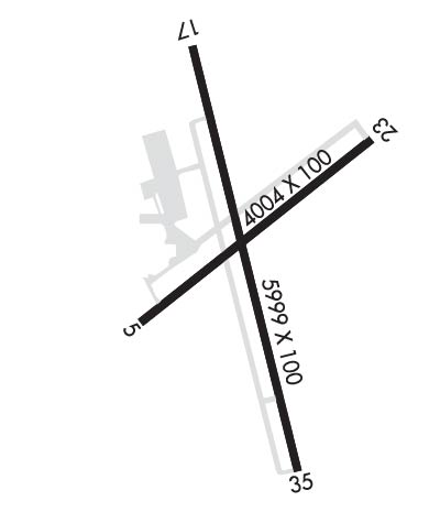 Airport Diagram might not be current. | |
| Facility Name: | OUTLAW FLD |
| City Name: | CLARKSVILLE |
| County: | MONTGOMERY |
| State abbrev: | TN |
| State Name: | TENNESSEE |
| Ownership: | PUBLICLY OWNED |
| Use: | OPEN TO THE PUBLIC |
| Owner's Name: | CLARKSVILLE MONTGOMERY COUNTY RAA |
| Address: | 200 A OUTLAW FIELD ROAD |
| CLARKSVILLE, TN 37042 | |
| Owner's Phone: | 931-431-2080 |
| Manager's Name: | JOHN PATTERSON |
| Address: | 200 AIRPORT ROAD - BLDG 1 |
| CLARKSVILLE, TN 37042 | |
| Phone: | 931-431-2080 |
| FAA Region: | SOUTHERN |
| FAA Field Office: | MEM |
| Date | Sunrise | Sunset |
|---|---|---|
| 09/24/21 Friday | 6:39 | 18:44 |
| 09/25/21 Saturday | 6:40 | 18:42 |
| 09/26/21 Sunday | 6:41 | 18:41 |
| 09/27/21 Monday | 6:41 | 18:39 |
| 09/28/21 Tuesday | 6:42 | 18:38 |
| 09/29/21 Wednesday | 6:43 | 18:36 |
| 09/30/21 Thursday | 6:44 | 18:35 |
| 10/01/21 Friday | 6:45 | 18:33 |
| 10/02/21 Saturday | 6:46 | 18:32 |
| 10/03/21 Sunday | 6:46 | 18:30 |
| 10/04/21 Monday | 6:47 | 18:29 |
| 10/05/21 Tuesday | 6:48 | 18:28 |
| 10/06/21 Wednesday | 6:49 | 18:26 |
| 10/07/21 Thursday | 6:50 | 18:25 |
| Airport Attendance Schedule | SAT-SUN 0800-1600, MON-FRI 0700-1800; ARPT UNATNDD CHRISTMAS, THANKSGIVING AND NEW YEARS. |
| Airport Status | OPERATIONAL (This Status can change at any time - please check NOTAMS) |
| Airport Lighting Schedule | ACTVT MALS RWY 35; REIL RWY 17 - CTAF. |
| Airport Storage Available | Tie Downs, Hanger |
| Extra Services Available | Air Ambulance, Flight Instruction, Aircraft Rental |
| Wind Indicator | YES - (lighted) |
| Control Tower | NO |
| CTAF Frequency | 122.800 |
| Unicom Frequency | 122.800 |
| Rotating Beacon Color | CLEAR-GREEN (Light Land Airport) |
| Segmented Circle | YES |
| Landing Fee | NO |
| Airport Inspected | STATE - performed by STATE AERONAUTICAL PERSONNEL |
| Inspection Date | 06/03/2020 |
| Type of Fuel Available | Grade 100LL, JET A; -10AFT HR SVC - 931-217-8765. |
| Airframe Repair Service | MAJOR |
| Power Plant Repair Service | MAJOR |
| Latitude | N3637.3 |
| Longitude | W08724.9 (ESTIMATED) |
| Arpt Elevation | 549ft (SURVEYED) |
| Magnetic Variation | 01W |
| 6 miles NW | of CLARKSVILLE |
| Traffic Pattern Altitude | 1050 |
| Sectional Chart | ST LOUIS |
| Operations (Reported) | Yearly | Avg. Daily |
|---|---|---|
| General Aviation Transient | 11000 | 30 |
| General Aviation Local | 15000 | 41 |
| Air Taxi | 1000 | 3 |
| Commerical | 0 | 0 |
| Commuter | 0 | 0 |
| Military | 5475 | 15 |
| Aircraft based on Field | |
|---|---|
| General Aviation Singles | 61 |
| General Aviation Multi | 3 |
| Jet Aircraft | 0 |
| General Aviation Helicopters | 3 |
| Military Aircraft | 0 |
| Gliders | 0 |
| Ultralights | 0 |
| FSS on field | NO |
| FSS tie-in | JACKSON |
| FSS Phone | 1-800-WX-BRIEF |
| Who issues Notams | CKV |
| Notam D service at airport | YES |
| ARTCC Name | MEMPHIS |
| Airport Certification | |
| Aircraft Rescue & Firefighting Index | None |
| Airport of Entry | No |
| Custom Landing Rights | No |
| Joint Civil/Military | No |
| Military Landing rights | YES |
| NATIONAL PLAN OF INTEGRATED AIRPORT SYSTEMS (NPIAS) |
| GRANT AGREEMENTS UNDER FAAP/ADAP/AIP |
| ASSURANCES PURSUANT TO TITLE VI, CIVIL RIGHTS ACT OF 1964 |
| EXTSV MIL & CIVIL FLIGHT TRNG WITHIN ARPT AREA. |
| DEER ON & INVOF ARPT. |
| FOR CD WHEN UNA VIA FREQ CTC CAMPBELL APCH AT 270-798-6441. |
Airport Communications & Frequencies:
| ||||||||||||||||
| Runway: 05 | Runway: 23 | ||
| Mag heading: | 53° | Mag heading: | 233° |
| Rwy Slope: | -.16% Down | Rwy Slope: | .16% Up |
| Approach: | Approach: | ||
| Pattern: | Right Traffic | Pattern: | Left Traffic |
| Markings: | NONPRECISION INSTRUMENT | Markings: | NONPRECISION INSTRUMENT |
| Marking Condition: | POOR; MARKINGS PEELING & FADED. | Marking Condition: | POOR; MARKINGS PEELING & FADED. |
| Arresting Dev: | Arresting Dev: | ||
| Lat & Long: | N3637.1 W08725.2 | Lat. & Long.: | N3637.6 W08724.6 |
| Elev: | 539.3 ft. MSL | Elev: | 532.7 ft. MSL |
| TCH: | TCH: | ||
| Visual Glide Path: | Visual Glide Path: | ||
| Displaced Threshold: | 402 feet | Displaced Threshold: | 503 feet |
| Touchdown Zone: | YES | Touchdown Zone: | YES |
| Touchdown Elev.: | 544.3 feet | Touchdown Elev.: | 544.3 feet |
| Visual Glide Slope: | Visual Glide Slope: | ||
| RVR Equipment: | RVR Equipment: | ||
| RVV Equipment: | NO | RVV Equipment: | NO |
| Approach Lights: | Approach Lights: | ||
| REIL: | NO | REIL: | NO |
| Centerline Lights: | NO | Centerline Lights: | NO |
| Touchdown lights: | NO | Touchdown lights: | NO |
| Runway Category: | Runway with a Visual Approach | Runway Category: | Runway with a Visual Approach |
| Declared Distances: | TORA:4004' TODA:4004' ASDA:3501' LDA:3099' | Declared Distances: | TORA:4004' TODA:4004' ASDA:3602' LDA:3099' |
| Obstructions: | TREE | Obstructions: | TREE |
| Marked: | NOT Marked/Lighted | Marked: | NOT Marked/Lighted |
| Clearance slope: | 3:1; APCH RATIO 12:1 TO DSPLCD THR. | Clearance slope: | 10:1; APCH RATIO 19:1 TO DSPLCD THR. |
| Obstruction height: | 64 feet AGL | Obstruction height: | 82 feet AGL |
| Dist. from runway: | 408 feet | Dist. from runway: | 1072 feet |
| Centerline offset: | 148 left of centerline | Centerline offset: | 7 feet left of centerline |
| Comments: | FENCE 100 FT FM RWY END. | Comments: | FENCE 100 FT FM RWY END. |
| Runway: 17 | Runway: 35 | ||
| Mag heading: | 167° | Mag heading: | 347° |
| Rwy Slope: | .19% Up | Rwy Slope: | -.19% Down |
| Approach: | Approach: | LOCALIZER | |
| Pattern: | Left Traffic | Pattern: | Right Traffic |
| Markings: | NONPRECISION INSTRUMENT | Markings: | NONPRECISION INSTRUMENT |
| Marking Condition: | GOOD | Marking Condition: | GOOD |
| Arresting Dev: | Arresting Dev: | ||
| Lat & Long: | N3637.8 W08725.1 | Lat. & Long.: | N3636.8 W08724.8 |
| Elev: | 538.0 ft. MSL | Elev: | 549.1 ft. MSL |
| TCH: | 22 ft. AGL | TCH: | 50 ft. AGL |
| Visual Glide Path: | 3.00 degrees | Visual Glide Path: | 3.00 degrees |
| Displaced Threshold: | No | Displaced Threshold: | No |
| Touchdown Zone: | YES | Touchdown Zone: | YES |
| Touchdown Elev.: | 541.3 feet | Touchdown Elev.: | 549.9 feet |
| Visual Glide Slope: | 2-Light PAPI on LEFT side of Runway; PAPI RWY 17 UNUSBL BYD 9 DEG RIGHT OF CNTLN. | Visual Glide Slope: | 2-Light PAPI on LEFT side of Runway |
| RVR Equipment: | RVR Equipment: | ||
| RVV Equipment: | NO | RVV Equipment: | NO |
| Approach Lights: | Approach Lights: | MALS - 1,400 foot medium intensity approach lighting system | |
| REIL: | YES | REIL: | NO |
| Centerline Lights: | NO | Centerline Lights: | NO |
| Touchdown lights: | NO | Touchdown lights: | NO |
| Runway Category: | Runway with a Non-precision Approach having visibility minimums greater than 3/4 mile | Runway Category: | D |
| Declared Distances: | Declared Distances: | ||
| Obstructions: | TREES | Obstructions: | TREES |
| Marked: | NOT Marked/Lighted | Marked: | NOT Marked/Lighted |
| Clearance slope: | 23:1 | Clearance slope: | 27:1 |
| Obstruction height: | 91 feet AGL | Obstruction height: | 73 feet AGL |
| Dist. from runway: | 2335 feet | Dist. from runway: | 2173 feet |
| Centerline offset: | 459 left of centerline | Centerline offset: | 382 feet left of centerline |
| Comments: | Comments: |
Thanks for using FltPlan.com
all rights reserved © 1999-2021 by Flight Plan LLC
