
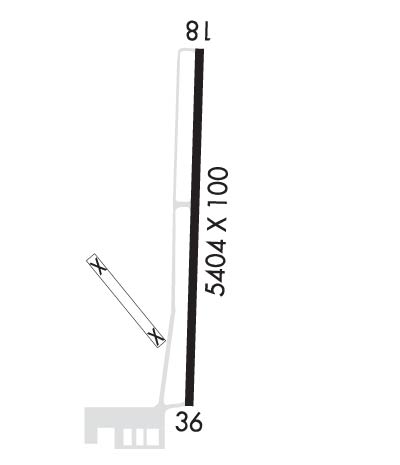
| FLETCHER FIELD CLARKSDALE MS |
| |
| Lat: N 3418.0 Long: W 09030.7 Elev: 173 Var: +00 Longest Runway: 5404 | ||
| AWOS: 120.67 CTAF: 122.8 | ||
| ||||||
| ||||||
|
| Rwy | Rwy | |||||||
| 5404x100 | 5404' | 5404x100 | 5404' | |||||
| Runway ID | Single Wheel | Double Wheel | Double Tandem Wheel | Dual Double Wheel |
| 18/36 | 25,000 | 32,000 | N/A | N/A |
| These numbers are Advisory and are not limits. The Airport Manager should have more accurate Weight Limits | ||||
 Airport Diagram might not be current. | |
| Facility Name: | FLETCHER FLD |
| City Name: | CLARKSDALE |
| County: | COAHOMA |
| State abbrev: | MS |
| State Name: | MISSISSIPPI |
| Ownership: | PUBLICLY OWNED |
| Use: | OPEN TO THE PUBLIC |
| Owner's Name: | COAHOMA CO ARPT BOARD; AND CITY OF CLARKSDALE. |
| Address: | PO BOX 406 |
| CLARKSDALE, MS 38614 | |
| Owner's Phone: | 662-624-5554 |
| Manager's Name: | DAVID HUGGINS |
| Address: | PO BOX 700 |
| CLARKSDALE, MS 38614 | |
| Phone: | 662-627-4126 |
| FAA Region: | SOUTHERN |
| FAA Field Office: | JAN |
| Date | Sunrise | Sunset |
|---|---|---|
| 06/08/26 Monday | 5:50 | 20:13 |
| 06/09/26 Tuesday | 5:50 | 20:13 |
| 06/10/26 Wednesday | 5:49 | 20:14 |
| 06/11/26 Thursday | 5:49 | 20:14 |
| 06/12/26 Friday | 5:49 | 20:14 |
| 06/13/26 Saturday | 5:49 | 20:15 |
| 06/14/26 Sunday | 5:49 | 20:15 |
| 06/15/26 Monday | 5:49 | 20:16 |
| 06/16/26 Tuesday | 5:50 | 20:16 |
| 06/17/26 Wednesday | 5:50 | 20:16 |
| 06/18/26 Thursday | 5:50 | 20:17 |
| 06/19/26 Friday | 5:50 | 20:17 |
| 06/20/26 Saturday | 5:50 | 20:17 |
| 06/21/26 Sunday | 5:50 | 20:17 |
| Airport Attendance Schedule | 7 Days A Week DALGT |
| Airport Status | OPERATIONAL (This Status can change at any time - please check NOTAMS) |
| Airport Lighting Schedule | ACTVT REIL RWY 18 & 36; MIRL RWY 18/36 - CTAF. PAPI RWY 18 & 36 OPR CONSLY. |
| Airport Storage Available | Tie Downs, Hanger |
| Extra Services Available | Crop Dusting, Flight Instruction, Aircraft Rental |
| Wind Indicator | YES - (lighted) |
| Control Tower | NO |
| CTAF Frequency | 122.800 |
| Unicom Frequency | 122.800 |
| Rotating Beacon Color | WG |
| Segmented Circle | YES |
| Landing Fee | NO |
| Airport Inspected | STATE - performed by STATE AERONAUTICAL PERSONNEL |
| Inspection Date | 12/19/2024 |
| Type of Fuel Available | Grade 100LL, JET A (freeze point -40C); -10FUEL AVBL 24 HRS WITH CREDIT CARD. OTS INDEF. |
| Airframe Repair Service | None |
| Power Plant Repair Service | MINOR |
| Latitude | N3418.0 |
| Longitude | W09030.7 (ESTIMATED) |
| Arpt Elevation | 173ft (SURVEYED) |
| Magnetic Variation | 00W |
| 7 miles NE | of CLARKSDALE |
| Traffic Pattern Altitude | |
| Sectional Chart | MEMPHIS |
| Operations (Reported) | Yearly | Avg. Daily |
|---|---|---|
| General Aviation Transient | 0 | 0 |
| General Aviation Local | 0 | 0 |
| Air Taxi | 0 | 0 |
| Commerical | 0 | 0 |
| Commuter | 0 | 0 |
| Military | 0 | 0 |
| Aircraft based on Field | |
|---|---|
| General Aviation Singles | 0 |
| General Aviation Multi | 0 |
| Jet Aircraft | 0 |
| General Aviation Helicopters | 0 |
| Military Aircraft | 0 |
| Gliders | 0 |
| Ultralights | 0 |
| FSS on field | NO |
| FSS tie-in | GREENWOOD |
| FSS Phone | 1-800-WX-BRIEF |
| Who issues Notams | GWO |
| Notam D service at airport | YES |
| ARTCC Name | MEMPHIS |
| Airport Certification | |
| Aircraft Rescue & Firefighting Index | None |
| Airport of Entry | No |
| Custom Landing Rights | No |
| Joint Civil/Military | No |
| Military Landing rights | YES |
| NATIONAL PLAN OF INTEGRATED AIRPORT SYSTEMS (NPIAS) |
| GRANT AGREEMENTS UNDER FAAP/ADAP/AIP |
| SURPLUS PROPERTY AGREEMENT UNDER PUBLIC LAW 289 |
| ASSURANCES PURSUANT TO TITLE VI, CIVIL RIGHTS ACT OF 1964 |
| NMRS AGRICULTURAL ACFT OPS W OF N/S TWY. ACFT DEP N & LAND S. |
| TWY LGTS ON S STUB TWY TO APN. |
| FOR CD CTC MEMPHIS ARTCC AT 901-368-8453/8449. |
| RWY 18/3 6 1 HR PPR FOR ACFT OVER 30000 LBS, CALL 662-624-5554 OR 662-902-1893. |
Airport Communications & Frequencies:
| |||||||||
| Runway: 18 | Runway: 36 | ||
| Mag heading: | 183° | Mag heading: | 3° |
| Rwy Slope: | .02% Up | Rwy Slope: | -.02% Down |
| Approach: | Approach: | ||
| Pattern: | Left Traffic | Pattern: | Left Traffic |
| Markings: | NONPRECISION INSTRUMENT | Markings: | NONPRECISION INSTRUMENT |
| Marking Condition: | FAIR | Marking Condition: | FAIR |
| Arresting Dev: | Arresting Dev: | ||
| Lat & Long: | N3418.4 W09030.7 | Lat. & Long.: | N3417.5 W09030.8 |
| Elev: | 171.5 ft. MSL | Elev: | 172.5 ft. MSL |
| TCH: | 40 ft. AGL | TCH: | 45 ft. AGL |
| Visual Glide Path: | 3.00 degrees | Visual Glide Path: | 3.00 degrees |
| Displaced Threshold: | No | Displaced Threshold: | No |
| Touchdown Zone: | YES | Touchdown Zone: | YES |
| Touchdown Elev.: | 173.3 feet | Touchdown Elev.: | 172.8 feet |
| Visual Glide Slope: | 4-Light PAPI on RIGHT side of Runway | Visual Glide Slope: | 4-Light PAPI on LEFT side of Runway |
| RVR Equipment: | RVR Equipment: | ||
| RVV Equipment: | NO | RVV Equipment: | NO |
| Approach Lights: | Approach Lights: | ||
| REIL: | YES | REIL: | YES |
| Centerline Lights: | NO | Centerline Lights: | NO |
| Touchdown lights: | NO | Touchdown lights: | NO |
| Runway Category: | Runway with a Non-precision Approach | Runway Category: | Runway with a Non-precision Approach |
| Declared Distances: | Declared Distances: | ||
| Obstructions: | Obstructions: | TREES | |
| Marked: | Marked: | NOT Marked/Lighted | |
| Clearance slope: | 50:1 | Clearance slope: | 21:1 |
| Obstruction height: | Obstruction height: | 95 feet AGL | |
| Dist. from runway: | Dist. from runway: | 2240 feet | |
| Centerline offset: | Centerline offset: | 200 feet right of centerline | |
| Comments: | Comments: |
Thanks for using FltPlan.com
all rights reserved © 1999-2026 by Flight Plan LLC
