
| CULPEPER RGNL CULPEPER VA |
| |
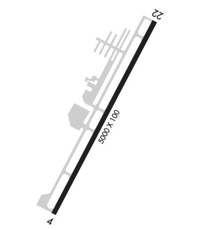
| Lat: N 3831.5 Long: W 07751.6 Elev: 316 Var: +10 Longest Runway: 5000 | ||
| Clr Del: 121.6 AWOS: 119.32 CTAF: 123.07 | ||
| ||||||||||||||||||||||||||||||||||||||||||||
| ||||||||||||||||||||||||||||||||||||||||||||
| ||||||||||||||||||||||||||||||||||||||||||||
| Rwy | Rwy | |||||||
| 5000x100 | 5000' | 109.95 - 038° | 5000x100 | 5000' | ||||
| Runway ID | Single Wheel | Double Wheel | Double Tandem Wheel | Dual Double Wheel |
| 04/22 | 40,000 | N/A | N/A | N/A |
| These numbers are Advisory and are not limits. The Airport Manager should have more accurate Weight Limits | ||||
 Airport Diagram might not be current. | |
| Facility Name: | CULPEPER RGNL |
| City Name: | CULPEPER |
| County: | CULPEPER |
| State abbrev: | VA |
| State Name: | VIRGINIA |
| Ownership: | PUBLICLY OWNED |
| Use: | OPEN TO THE PUBLIC |
| Owner's Name: | COUNTY OF CULPEPER |
| Address: | 302 N MAIN ST |
| CULPEPER, VA 22701 | |
| Owner's Phone: | 540-727-3427 |
| Manager's Name: | TANYA WOODWARD |
| Address: | 12517 BEVERLY FORD ROAD |
| BRANDY STATION, VA 22714 | |
| Phone: | 540-825-8280 |
| FAA Region: | EASTERN |
| FAA Field Office: | DCA |
| Date | Sunrise | Sunset |
|---|---|---|
| 06/08/26 Monday | 5:47 | 20:34 |
| 06/09/26 Tuesday | 5:47 | 20:35 |
| 06/10/26 Wednesday | 5:47 | 20:35 |
| 06/11/26 Thursday | 5:47 | 20:36 |
| 06/12/26 Friday | 5:47 | 20:36 |
| 06/13/26 Saturday | 5:47 | 20:36 |
| 06/14/26 Sunday | 5:47 | 20:37 |
| 06/15/26 Monday | 5:47 | 20:37 |
| 06/16/26 Tuesday | 5:47 | 20:38 |
| 06/17/26 Wednesday | 5:47 | 20:38 |
| 06/18/26 Thursday | 5:47 | 20:38 |
| 06/19/26 Friday | 5:47 | 20:38 |
| 06/20/26 Saturday | 5:47 | 20:39 |
| 06/21/26 Sunday | 5:47 | 20:39 |
| Airport Attendance Schedule | 7 Days A Week 0800-1800; HOURS CHANGE MID-OCT, CHECK NOTAMS FOR DETAILS. |
| Airport Status | OPERATIONAL (This Status can change at any time - please check NOTAMS) |
| Airport Lighting Schedule | ACTVT REIL RWY 04 & 22; PAPI RWY 04 & 22; MIRL RWY 04/22; TWY LGTS - CTAF. |
| Airport Storage Available | Tie Downs |
| Extra Services Available | Air Ambulance, Flight Instruction, Aircraft Rental |
| Wind Indicator | YES - (lighted) |
| Control Tower | NO |
| CTAF Frequency | 123.075 |
| Unicom Frequency | 123.075 |
| Rotating Beacon Color | WG |
| Segmented Circle | YES |
| Landing Fee | YES; LNDG FEE FOR ACFT 8000 LBS OR GTR. CTC 540-825-8280 FOR FEE INFO. |
| Airport Inspected | STATE - performed by STATE AERONAUTICAL PERSONNEL |
| Inspection Date | 10/28/2024 |
| Type of Fuel Available | Grade 100LL, JET A |
| Airframe Repair Service | MAJOR |
| Power Plant Repair Service | MAJOR |
| Latitude | N3831.5 |
| Longitude | W07751.6 (ESTIMATED) |
| Arpt Elevation | 315ft (SURVEYED) |
| Magnetic Variation | 10W |
| 7 miles NE | of CULPEPER |
| Traffic Pattern Altitude | |
| Sectional Chart | WASHINGTON |
| Operations (Reported) | Yearly | Avg. Daily |
|---|---|---|
| General Aviation Transient | 0 | 0 |
| General Aviation Local | 0 | 0 |
| Air Taxi | 0 | 0 |
| Commerical | 0 | 0 |
| Commuter | 0 | 0 |
| Military | 0 | 0 |
| Aircraft based on Field | |
|---|---|
| General Aviation Singles | 0 |
| General Aviation Multi | 0 |
| Jet Aircraft | 0 |
| General Aviation Helicopters | 0 |
| Military Aircraft | 0 |
| Gliders | 0 |
| Ultralights | 0 |
| FSS on field | NO |
| FSS tie-in | LEESBURG |
| FSS Phone | 1-800-WX-BRIEF |
| Who issues Notams | CJR |
| Notam D service at airport | YES |
| ARTCC Name | WASHINGTON |
| Airport Certification | |
| Aircraft Rescue & Firefighting Index | None |
| Airport of Entry | No |
| Custom Landing Rights | No |
| Joint Civil/Military | No |
| Military Landing rights | YES |
| NATIONAL PLAN OF INTEGRATED AIRPORT SYSTEMS (NPIAS) |
| GRANT AGREEMENTS UNDER FAAP/ADAP/AIP |
| ASSURANCES PURSUANT TO TITLE VI, CIVIL RIGHTS ACT OF 1964 |
| THIS AIRPORT HAS BEEN SURVEYED BY THE NATIONAL GEODETIC SURVEY. |
| DEER ON AND INVOF ARPT. |
| GCO AVBL ON FREQ 121.6 THRU POTOMAC APCH CD. IF UNA, FOR CD CTC POTOMAC APCH AT 866-709-4993. |
| CALL OUT SVC AVBL; FEES APPLY. |
| MED-FLIGHT: IREG DEP PAT. |
Airport Communications & Frequencies:
| ||||||||||||||||
| Runway: 04 | Runway: 22 | ||
| Mag heading: | 38° | Mag heading: | 218° |
| Rwy Slope: | -.02% Down | Rwy Slope: | .02% Up |
| Approach: | LOC/DME | Approach: | |
| Pattern: | Left Traffic | Pattern: | Left Traffic |
| Markings: | NONPRECISION INSTRUMENT | Markings: | NONPRECISION INSTRUMENT |
| Marking Condition: | GOOD | Marking Condition: | GOOD |
| Arresting Dev: | Arresting Dev: | ||
| Lat & Long: | N3831.2 W07751.8 | Lat. & Long.: | N3831.9 W07751.3 |
| Elev: | 315.3 ft. MSL | Elev: | 314.5 ft. MSL |
| TCH: | 40 ft. AGL | TCH: | 40 ft. AGL |
| Visual Glide Path: | 3.00 degrees | Visual Glide Path: | 3.00 degrees |
| Displaced Threshold: | No | Displaced Threshold: | No |
| Touchdown Zone: | YES | Touchdown Zone: | YES |
| Touchdown Elev.: | 315.5 feet | Touchdown Elev.: | 314.5 feet |
| Visual Glide Slope: | 4-Light PAPI on LEFT side of Runway | Visual Glide Slope: | 4-Light PAPI on LEFT side of Runway |
| RVR Equipment: | RVR Equipment: | ||
| RVV Equipment: | NO | RVV Equipment: | NO |
| Approach Lights: | Approach Lights: | ||
| REIL: | YES | REIL: | YES |
| Centerline Lights: | NO | Centerline Lights: | NO |
| Touchdown lights: | NO | Touchdown lights: | NO |
| Runway Category: | Runway with a Non-precision Approach having visibility minimums greater than 3/4 mile | Runway Category: | Runway with a Non-precision Approach having visibility minimums greater than 3/4 mile |
| Declared Distances: | Declared Distances: | ||
| Obstructions: | TREES | Obstructions: | TREES |
| Marked: | NOT Marked/Lighted | Marked: | LIGHTED |
| Clearance slope: | 21:1 | Clearance slope: | 16:1 |
| Obstruction height: | 33 feet AGL | Obstruction height: | 70 feet AGL |
| Dist. from runway: | 915 feet | Dist. from runway: | 1363 feet |
| Centerline offset: | 247 left of centerline | Centerline offset: | 348 feet left of centerline |
| Comments: | Comments: |
Thanks for using FltPlan.com
all rights reserved © 1999-2026 by Flight Plan LLC
