
| ELLEN CHURCH FIELD CRESCO IA |
| |
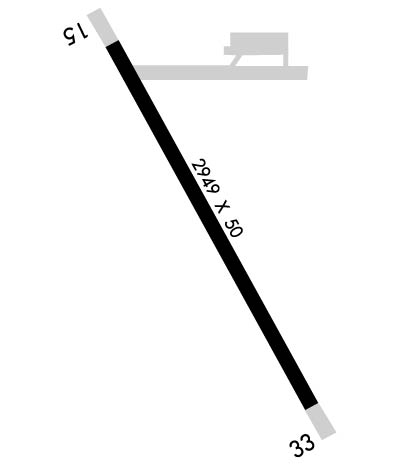
| Lat: N 4321.9 Long: W 09208.0 Elev: 1279 Var: -02 Longest Runway: 2949 | ||
| CTAF: 122.8 | ||
| ||
| Rwy | Rwy | |||||||
| 2949x50 | 2949' | 2949x50 | 2949' | |||||
| Runway ID | Single Wheel | Double Wheel | Double Tandem Wheel | Dual Double Wheel |
| 15/33 | 29,000 | N/A | N/A | N/A |
| These numbers are Advisory and are not limits. The Airport Manager should have more accurate Weight Limits | ||||
 Airport Diagram might not be current. | |
| Facility Name: | ELLEN CHURCH FLD |
| City Name: | CRESCO |
| County: | HOWARD |
| State abbrev: | IA |
| State Name: | IOWA |
| Ownership: | PUBLICLY OWNED |
| Use: | OPEN TO THE PUBLIC |
| Owner's Name: | CITY OF CRESCO |
| Address: | 130 NORTH PARK PLACE |
| CRESCO, IA 52136 | |
| Owner's Phone: | 319-547-3101 |
| Manager's Name: | CLAIR PECINOVSKY |
| Address: | 12848 WELL ROAD |
| CRESCO, IA 52136 | |
| Phone: | 563-547-4898 |
| FAA Region: | CENTRAL |
| FAA Field Office: | NONE |

| Date | Sunrise | Sunset |
|---|---|---|
| 07/10/26 Friday | 5:38 | 20:50 |
| 07/11/26 Saturday | 5:38 | 20:49 |
| 07/12/26 Sunday | 5:39 | 20:49 |
| 07/13/26 Monday | 5:40 | 20:48 |
| 07/14/26 Tuesday | 5:41 | 20:48 |
| 07/15/26 Wednesday | 5:42 | 20:47 |
| 07/16/26 Thursday | 5:42 | 20:46 |
| 07/17/26 Friday | 5:43 | 20:46 |
| 07/18/26 Saturday | 5:44 | 20:45 |
| 07/19/26 Sunday | 5:45 | 20:44 |
| 07/20/26 Monday | 5:46 | 20:43 |
| 07/21/26 Tuesday | 5:47 | 20:42 |
| 07/22/26 Wednesday | 5:48 | 20:41 |
| 07/23/26 Thursday | 5:49 | 20:41 |
| Airport Attendance Schedule | UNATTENDED |
| Airport Status | OPERATIONAL (This Status can change at any time - please check NOTAMS) |
| Airport Lighting Schedule | ACTVT LIRL RWY 15/33 - 122.7. |
| Airport Storage Available | Tie Downs |
| Extra Services Available | NONE |
| Wind Indicator | YES - (lighted) |
| Control Tower | NO |
| CTAF Frequency | 122.800; CTAF/UNICOM OTS INDEFLY. |
| Unicom Frequency | 122.800; ANSWERED BY POLICE; NOT ON FIELD. |
| Rotating Beacon Color | |
| Segmented Circle | NO |
| Landing Fee | NO |
| Airport Inspected | STATE - performed by STATE AERONAUTICAL PERSONNEL |
| Inspection Date | 06/27/2024 |
| Type of Fuel Available | None |
| Airframe Repair Service | NONE |
| Power Plant Repair Service | NONE |
| Latitude | N4321.9 |
| Longitude | W09208.0 (ESTIMATED) |
| Arpt Elevation | 1279ft (SURVEYED) |
| Magnetic Variation | 02E |
| 1 miles SW | of CRESCO |
| Traffic Pattern Altitude | |
| Sectional Chart | CHICAGO |
| Operations (Reported) | Yearly | Avg. Daily |
|---|---|---|
| General Aviation Transient | 0 | 0 |
| General Aviation Local | 0 | 0 |
| Air Taxi | 0 | 0 |
| Commerical | 0 | 0 |
| Commuter | 0 | 0 |
| Military | 0 | 0 |
| Aircraft based on Field | |
|---|---|
| General Aviation Singles | 0 |
| General Aviation Multi | 0 |
| Jet Aircraft | 0 |
| General Aviation Helicopters | 0 |
| Military Aircraft | 0 |
| Gliders | 0 |
| Ultralights | 0 |
| FSS on field | NO |
| FSS tie-in | FORT DODGE |
| FSS Phone | 1-800-WX-BRIEF |
| Who issues Notams | FOD |
| Notam D service at airport | YES |
| ARTCC Name | MINNEAPOLIS |
| Airport Certification | |
| Aircraft Rescue & Firefighting Index | None |
| Airport of Entry | No |
| Custom Landing Rights | No |
| Joint Civil/Military | No |
| Military Landing rights | YES |
| GRANT AGREEMENTS UNDER FAAP/ADAP/AIP |
| ASSURANCES PURSUANT TO TITLE VI, CIVIL RIGHTS ACT OF 1964 |
| THIS AIRPORT HAS BEEN SURVEYED BY THE NATIONAL GEODETIC SURVEY. |
| BE ALERT FOR ULTRALIGHT ACTIVITY ON & INVOF ARPT. |
| FOR CD CTC ROCHESTER APCH AT 507-424-8111. FOR CD WHEN ROCHESTER APCH IS CLOSED, CTC MINNEAPOLIS ARTCC AT 651-463-5588. |
| SNOW REMOVAL DELAYED AT TIMES; CONFIRM RWY CONDITIONS PRIOR TO USE: CALL 563-547-4898 OR AMGR, 563-379-5898. |
Airport Communications & Frequencies:
| |||||||||
| Runway: 15 | Runway: 33 | ||
| Mag heading: | 152° | Mag heading: | 332° |
| Rwy Slope: | -.47% Down | Rwy Slope: | .47% Up |
| Approach: | Approach: | ||
| Pattern: | Left Traffic | Pattern: | Left Traffic |
| Markings: | NONPRECISION INSTRUMENT | Markings: | NONPRECISION INSTRUMENT |
| Marking Condition: | FAIR | Marking Condition: | FAIR |
| Arresting Dev: | Arresting Dev: | ||
| Lat & Long: | N4322.1 W09208.1 | Lat. & Long.: | N4321.7 W09207.8 |
| Elev: | 1279.0 ft. MSL | Elev: | 1265.0 ft. MSL |
| TCH: | TCH: | ||
| Visual Glide Path: | Visual Glide Path: | ||
| Displaced Threshold: | No | Displaced Threshold: | No |
| Touchdown Zone: | YES | Touchdown Zone: | YES |
| Touchdown Elev.: | 1279.0 feet | Touchdown Elev.: | 1279.0 feet |
| Visual Glide Slope: | Visual Glide Slope: | ||
| RVR Equipment: | RVR Equipment: | ||
| RVV Equipment: | NO | RVV Equipment: | NO |
| Approach Lights: | Approach Lights: | ||
| REIL: | NO | REIL: | NO |
| Centerline Lights: | NO | Centerline Lights: | NO |
| Touchdown lights: | NO | Touchdown lights: | NO |
| Runway Category: | Runway with a Non-precision Approach | Runway Category: | Runway with a Non-precision Approach |
| Declared Distances: | Declared Distances: | ||
| Obstructions: | TREE | Obstructions: | POLE |
| Marked: | NOT Marked/Lighted | Marked: | NOT Marked/Lighted |
| Clearance slope: | 20:1 | Clearance slope: | 20:1 |
| Obstruction height: | 74 feet AGL | Obstruction height: | 25 feet AGL |
| Dist. from runway: | 1736 feet | Dist. from runway: | 714 feet |
| Centerline offset: | 86 left of centerline | Centerline offset: | 228 feet left of centerline |
| Comments: | Comments: |
Thanks for using FltPlan.com
all rights reserved © 1999-2026 by Flight Plan LLC