
| CHICO MUNI CHICO CA |
| |
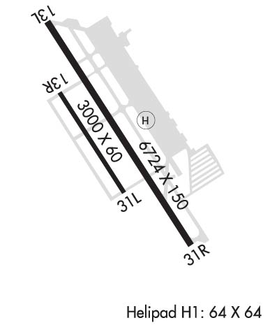
| Lat: N 3947.7 Long: W 12151.5 Elev: 240 Var: -16 Longest Runway: 6724 | ||
| Dept. ATIS: 119.67 Arr. ATIS: 119.67 AWOS: 119.67 Ground: 121.9 Tower: 121.0 | ||
| ||||||
| ||||||
|
| Rwy | Rwy | |||||||
| 6724x150 | 6724' | 111.30 - 131° | 6724x150 | 6724' | ||||
| 3000x60 | 3000' | 3000x60 | 3000' | |||||
| Runway ID | Single Wheel | Double Wheel | Double Tandem Wheel | Dual Double Wheel |
| 13L/31R | 63,000 | 100,000 | 170,000 | N/A |
| 13R/31L | 12,500 | N/A | N/A | N/A |
| H1 | 35,000 | N/A | N/A | N/A |
| These numbers are Advisory and are not limits. The Airport Manager should have more accurate Weight Limits | ||||
 Airport Diagram might not be current. | |
| Facility Name: | CHICO MUNI |
| City Name: | CHICO |
| County: | BUTTE |
| State abbrev: | CA |
| State Name: | CALIFORNIA |
| Ownership: | PUBLICLY OWNED |
| Use: | OPEN TO THE PUBLIC |
| Owner's Name: | CITY OF CHICO |
| Address: | PO BOX 3420 |
| CHICO, CA 95927 | |
| Owner's Phone: | 530-896-7200 |
| Manager's Name: | TOM BAHR |
| Address: | 150 AIRPARK BLVD., SUITE 110 |
| CHICO, CA 95973 | |
| Phone: | 530-896-7216 |
| FAA Region: | WESTERN-PACIFIC |
| FAA Field Office: | SFO |
| Date | Sunrise | Sunset |
|---|---|---|
| 09/24/21 Friday | 6:57 | 19:01 |
| 09/25/21 Saturday | 6:58 | 19:00 |
| 09/26/21 Sunday | 6:59 | 18:58 |
| 09/27/21 Monday | 7:00 | 18:57 |
| 09/28/21 Tuesday | 7:01 | 18:55 |
| 09/29/21 Wednesday | 7:02 | 18:53 |
| 09/30/21 Thursday | 7:03 | 18:52 |
| 10/01/21 Friday | 7:03 | 18:50 |
| 10/02/21 Saturday | 7:04 | 18:48 |
| 10/03/21 Sunday | 7:05 | 18:47 |
| 10/04/21 Monday | 7:06 | 18:45 |
| 10/05/21 Tuesday | 7:07 | 18:44 |
| 10/06/21 Wednesday | 7:08 | 18:42 |
| 10/07/21 Thursday | 7:09 | 18:40 |
| Airport Attendance Schedule | 7 Days A Week 0700-1900 |
| Airport Status | OPERATIONAL (This Status can change at any time - please check NOTAMS) |
| Airport Lighting Schedule | WHEN ATCT CLSD ACTVT MALSR RWY 13L; REIL RWY 31R; PAPI RWY 13L; VASI RWY 31R; HIRL RWY 13L/31R - CTAF. |
| Airport Storage Available | Tie Downs |
| Extra Services Available | Air Freight, Crop Dusting, Avionics, Charter, Flight Instruction, Aircraft Rental, Aircraft Sales |
| Wind Indicator | YES - (lighted) |
| Control Tower | YES |
| CTAF Frequency | 121.000 |
| Unicom Frequency | 122.950 |
| Rotating Beacon Color | CLEAR-GREEN (Light Land Airport) |
| Segmented Circle | YES |
| Landing Fee | NO |
| Airport Inspected | FEDERAL - performed by STATE AERONAUTICAL PERSONNEL |
| Inspection Date | 09/18/2019 |
| Type of Fuel Available | Grade 100LL, JET A (freeze point -40C); -10FOR FUEL AFT HRS CALL (530) 588-4888 |
| Airframe Repair Service | MAJOR |
| Power Plant Repair Service | MAJOR |
| Latitude | N3947.7 |
| Longitude | W12151.5 (ESTIMATED) |
| Arpt Elevation | 240ft (SURVEYED) |
| Magnetic Variation | 16E |
| 4 miles N | of CHICO |
| Traffic Pattern Altitude | |
| Sectional Chart | SAN FRANCISCO |
| Operations (Reported) | Yearly | Avg. Daily |
|---|---|---|
| General Aviation Transient | 19546 | 54 |
| General Aviation Local | 6170 | 17 |
| Air Taxi | 6719 | 18 |
| Commerical | 21 | 0 |
| Commuter | 0 | 0 |
| Military | 1544 | 4 |
| Aircraft based on Field | |
|---|---|
| General Aviation Singles | 75 |
| General Aviation Multi | 10 |
| Jet Aircraft | 2 |
| General Aviation Helicopters | 3 |
| Military Aircraft | 0 |
| Gliders | 0 |
| Ultralights | 0 |
| FSS on field | NO |
| FSS tie-in | RANCHO MURIETA |
| FSS Phone | 1-800-WX-BRIEF |
| Who issues Notams | CIC |
| Notam D service at airport | YES |
| ARTCC Name | OAKLAND |
| Airport Certification | PPR FOR SKEDD ACR SER INVOLVING ACFT WITH MORE THAN 9 PAX SEATS AND UNSKEDD ACR SER INVOLVING ACFT WITH MORE THAN 30 PAX SEATS. WITHOUT PPR, ARFF SERS MAY NOT BE AVBL. FOR PPR CTC AMGR, 530-896-7216. |
| Aircraft Rescue & Firefighting Index | AIRPORT HAS A CERTIFICATE UNDER CFR PART 139 |
| Airport of Entry | No |
| Custom Landing Rights | No |
| Joint Civil/Military | No |
| Military Landing rights | YES |
| NATIONAL PLAN OF INTEGRATED AIRPORT SYSTEMS (NPIAS) |
| GRANT AGREEMENTS UNDER FAAP/ADAP/AIP |
| SURPLUS PROPERTY AGREEMENT UNDER PUBLIC LAW 289 |
| SURPLUS PROPERTY AGREEMENT UNDER REGULATION 16-WAA |
| ASSURANCES PURSUANT TO TITLE VI, CIVIL RIGHTS ACT OF 1964 |
| FOR JET/HVY ACFT OPER EAST OF FLD TPA 1500 FT AGL; FOR LGT ACFT OPER WEST & EAST OF FLD TPA 1000 FT AGL. |
| BIRDS ON AND IN VCNTY OF ARPT. |
| TWY Z CLSD. |
| FUEL AVBL 0730-1900. FOR AFTER HRS FUEL CALL 530-588-4888. |
Airport Communications & Frequencies:
| |||||||||||||||||
| Runway: 13L | Runway: 31R | ||
| Mag heading: | 131° | Mag heading: | 311° |
| Rwy Slope: | -.49% Down | Rwy Slope: | .49% Up |
| Approach: | ILS/DME | Approach: | |
| Pattern: | Right Traffic | Pattern: | Left Traffic |
| Markings: | PRECISION INSTRUMENT | Markings: | PRECISION INSTRUMENT |
| Marking Condition: | GOOD | Marking Condition: | GOOD |
| Arresting Dev: | Arresting Dev: | ||
| Lat & Long: | N3948.2 W12151.8 | Lat. & Long.: | N3947.3 W12151.1 |
| Elev: | 240.2 ft. MSL | Elev: | 207.2 ft. MSL |
| TCH: | 52 ft. AGL | TCH: | 54 ft. AGL |
| Visual Glide Path: | 3.00 degrees | Visual Glide Path: | 3.00 degrees |
| Displaced Threshold: | No | Displaced Threshold: | No |
| Touchdown Zone: | YES | Touchdown Zone: | YES |
| Touchdown Elev.: | 240.2 feet | Touchdown Elev.: | 226.3 feet |
| Visual Glide Slope: | 4-Light PAPI on LEFT side of Runway | Visual Glide Slope: | 4-BOX VASI ON LEFT SIDE OF RUNWAY |
| RVR Equipment: | RVR Equipment: | ||
| RVV Equipment: | NO | RVV Equipment: | NO |
| Approach Lights: | MALSR - 1,400 foot medium intensity approach lighting system with runway alignment indicator lights | Approach Lights: | |
| REIL: | NO | REIL: | YES |
| Centerline Lights: | NO | Centerline Lights: | NO |
| Touchdown lights: | NO | Touchdown lights: | NO |
| Runway Category: | Precision Instrument Runway | Runway Category: | Runway with a Non-precision Approach having visibility minimums greater than 3/4 mile |
| Declared Distances: | TORA:6724' TODA:6724' ASDA:6724' LDA:6724' | Declared Distances: | TORA:6724' TODA:6724' ASDA:6724' LDA:6724' |
| Runway: 13R | Runway: 31L | ||
| Mag heading: | 131° | Mag heading: | 311° |
| Rwy Slope: | -.40% Down | Rwy Slope: | .40% Up |
| Approach: | Approach: | ||
| Pattern: | Right Traffic | Pattern: | Left Traffic |
| Markings: | BASIC | Markings: | BASIC |
| Marking Condition: | FAIR | Marking Condition: | FAIR |
| Arresting Dev: | Arresting Dev: | ||
| Lat & Long: | N3947.9 W12151.8 | Lat. & Long.: | N3947.5 W12151.4 |
| Elev: | 226.9 ft. MSL | Elev: | 215.0 ft. MSL |
| TCH: | TCH: | ||
| Visual Glide Path: | Visual Glide Path: | ||
| Displaced Threshold: | No | Displaced Threshold: | No |
| Touchdown Zone: | YES | Touchdown Zone: | YES |
| Touchdown Elev.: | 226.9 feet | Touchdown Elev.: | 226.9 feet |
| Visual Glide Slope: | Visual Glide Slope: | ||
| RVR Equipment: | RVR Equipment: | ||
| RVV Equipment: | NO | RVV Equipment: | NO |
| Approach Lights: | Approach Lights: | ||
| REIL: | NO | REIL: | NO |
| Centerline Lights: | NO | Centerline Lights: | NO |
| Touchdown lights: | NO | Touchdown lights: | NO |
| Runway Category: | Runway with a Visual Approach | Runway Category: | Runway with a Visual Approach |
| Declared Distances: | TORA:3000' TODA:3000' ASDA:3000' LDA:3000' | Declared Distances: | TORA:3000' TODA:3000' ASDA:3000' LDA:3000' |
Thanks for using FltPlan.com
all rights reserved © 1999-2021 by Flight Plan LLC
