| CHILLICOTHE MUNI CHILLICOTHE MO |
| |
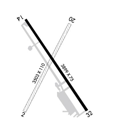
| Lat: N 3946.9 Long: W 09329.8 Elev: 783 Var: -03 Longest Runway: 3899 | ||
| AWOS: 118.17 CTAF: 122.8 | ||
| ||||||||||||||||||||||||||||||||||||||||||||||||||||||||||||
| ||||||||||||||||||||||||||||||||||||||||||||||||||||||||||||
| ||||||||||||||||||||||||||||||||||||||||||||||||||||||||||||
| Rwy | Rwy | |||||||
| 3503x110 | 3297' | 3503x110 | 3114' | |||||
| 3899x75 | 3899' | 3899x75 | 3899' | |||||
| Runway ID | Single Wheel | Double Wheel | Double Tandem Wheel | Dual Double Wheel |
| 02/20 | N/A | N/A | N/A | N/A |
| 14/32 | 15,000 | N/A | N/A | N/A |
| These numbers are Advisory and are not limits. The Airport Manager should have more accurate Weight Limits | ||||
 Airport Diagram might not be current. | |
| Facility Name: | CHILLICOTHE MUNI |
| City Name: | CHILLICOTHE |
| County: | LIVINGSTON |
| State abbrev: | MO |
| State Name: | MISSOURI |
| Ownership: | PUBLICLY OWNED |
| Use: | OPEN TO THE PUBLIC |
| Owner's Name: | CITY OF CHILLICOTHE |
| Address: | 715 WASHINGTON |
| CHILLICOTHE, MO 64601 | |
| Owner's Phone: | 660-646-1877 |
| Manager's Name: | BILL KIEFFER |
| Address: | 13844 LIV 253 |
| CHILLICOTHE, MO 64601 | |
| Phone: | 660-646-5270 |
| FAA Region: | CENTRAL |
| FAA Field Office: | NONE |
| Date | Sunrise | Sunset |
|---|---|---|
| 09/24/21 Friday | 7:03 | 19:08 |
| 09/25/21 Saturday | 7:04 | 19:06 |
| 09/26/21 Sunday | 7:05 | 19:05 |
| 09/27/21 Monday | 7:06 | 19:03 |
| 09/28/21 Tuesday | 7:07 | 19:02 |
| 09/29/21 Wednesday | 7:08 | 19:00 |
| 09/30/21 Thursday | 7:09 | 18:58 |
| 10/01/21 Friday | 7:10 | 18:57 |
| 10/02/21 Saturday | 7:11 | 18:55 |
| 10/03/21 Sunday | 7:12 | 18:53 |
| 10/04/21 Monday | 7:13 | 18:52 |
| 10/05/21 Tuesday | 7:14 | 18:50 |
| 10/06/21 Wednesday | 7:15 | 18:49 |
| 10/07/21 Thursday | 7:16 | 18:47 |
| Airport Attendance Schedule | MON-FRI 0800-1700, SAT 0800-1200 |
| Airport Status | OPERATIONAL (This Status can change at any time - please check NOTAMS) |
| Airport Lighting Schedule | ACTVT REIL RWYS 14 & 32; PAPI RWYS 14 & 32; MIRL RWY 14/32 - CTAF. |
| Airport Storage Available | Tie Downs, Hanger |
| Extra Services Available | Flight Instruction |
| Wind Indicator | YES - (unlit) |
| Control Tower | NO |
| CTAF Frequency | 122.800 |
| Unicom Frequency | 122.800 |
| Rotating Beacon Color | CLEAR-GREEN (Light Land Airport) |
| Segmented Circle | YES |
| Landing Fee | NO |
| Airport Inspected | STATE - performed by STATE AERONAUTICAL PERSONNEL |
| Inspection Date | 08/29/2019 |
| Type of Fuel Available | Grade 100LL |
| Airframe Repair Service | None |
| Power Plant Repair Service | None |
| Latitude | N3946.9 |
| Longitude | W09329.8 (ESTIMATED) |
| Arpt Elevation | 783ft (SURVEYED) |
| Magnetic Variation | 03E |
| 3 miles E | of CHILLICOTHE |
| Traffic Pattern Altitude | |
| Sectional Chart | KANSAS CITY |
| Operations (Reported) | Yearly | Avg. Daily |
|---|---|---|
| General Aviation Transient | 3800 | 10 |
| General Aviation Local | 2200 | 6 |
| Air Taxi | 230 | 1 |
| Commerical | 0 | 0 |
| Commuter | 0 | 0 |
| Military | 20 | 0 |
| Aircraft based on Field | |
|---|---|
| General Aviation Singles | 16 |
| General Aviation Multi | 1 |
| Jet Aircraft | 0 |
| General Aviation Helicopters | 1 |
| Military Aircraft | 0 |
| Gliders | 0 |
| Ultralights | 0 |
| FSS on field | NO |
| FSS tie-in | COLUMBIA |
| FSS Phone | 1-800-WX-BRIEF |
| Who issues Notams | COU |
| Notam D service at airport | YES |
| ARTCC Name | KANSAS CITY |
| Airport Certification | |
| Aircraft Rescue & Firefighting Index | None |
| Airport of Entry | No |
| Custom Landing Rights | No |
| Joint Civil/Military | No |
| Military Landing rights | YES |
| NATIONAL PLAN OF INTEGRATED AIRPORT SYSTEMS (NPIAS) |
| GRANT AGREEMENTS UNDER FAAP/ADAP/AIP |
| ASSURANCES PURSUANT TO TITLE VI, CIVIL RIGHTS ACT OF 1964 |
| WILDLIFE, MIGRATORY BIRDS & GEESE ON & INVOF ARPT. |
| NTSD RWY SAFETY AREA BYND BOTH ENDS OF RWY 02/20; INCORRECT TERRAIN GRADES AND CROPS. |
| PAEW INVOF ARPT. |
| FOR CD IF UNA TO CTC ON FSS FREQ, CTC KANSAS CITY ARTCC AT 913-254-8508. |
| RWY 14/3 2 RY 14/32 RESTRICTED TO ACFT 12,500 LBS MAX GWT OR LESS; PPR FOR ACFT EXCEEDING 12,500 LBS CALL AMGR ON 660-646-5270. |
Airport Communications & Frequencies:
| |||||||||
| Runway: 02 | Runway: 20 | ||
| Mag heading: | 23° | Mag heading: | 203° |
| Rwy Slope: | .44% Up | Rwy Slope: | -.44% Down |
| Approach: | Approach: | ||
| Pattern: | Left Traffic | Pattern: | Left Traffic |
| Markings: | Markings: | ||
| Marking Condition: | GOOD; RWY 02/20 MARKED WITH LARGE YELLOW CONES. DSPLCD THLDS MARKED WITH 3 LARGE YELLOW CONES ON EACH SIDE OF RY. | Marking Condition: | |
| Arresting Dev: | Arresting Dev: | ||
| Lat & Long: | N3946.7 W09330.0 | Lat. & Long.: | N3947.2 W09329.6 |
| Elev: | 756.9 ft. MSL | Elev: | 772.4 ft. MSL |
| TCH: | TCH: | ||
| Visual Glide Path: | Visual Glide Path: | ||
| Displaced Threshold: | 206 feet | Displaced Threshold: | 389 feet |
| Touchdown Zone: | YES | Touchdown Zone: | YES |
| Touchdown Elev.: | 778.4 feet | Touchdown Elev.: | 778.4 feet |
| Visual Glide Slope: | Visual Glide Slope: | ||
| RVR Equipment: | RVR Equipment: | ||
| RVV Equipment: | NO | RVV Equipment: | NO |
| Approach Lights: | Approach Lights: | ||
| REIL: | NO | REIL: | NO |
| Centerline Lights: | NO | Centerline Lights: | NO |
| Touchdown lights: | NO | Touchdown lights: | NO |
| Runway Category: | Runway with a Visual Approach | Runway Category: | Runway with a Visual Approach |
| Declared Distances: | Declared Distances: |
| Runway: 14 | Runway: 32 | ||
| Mag heading: | 140° | Mag heading: | 320° |
| Rwy Slope: | -.50% Down | Rwy Slope: | .50% Up |
| Approach: | Approach: | ||
| Pattern: | Left Traffic | Pattern: | Left Traffic |
| Markings: | NONPRECISION INSTRUMENT | Markings: | NONPRECISION INSTRUMENT |
| Marking Condition: | POOR; RWY 14 MKGS FADED. | Marking Condition: | POOR; RWY 32 MKGS FADED. |
| Arresting Dev: | Arresting Dev: | ||
| Lat & Long: | N3947.2 W09330.0 | Lat. & Long.: | N3946.7 W09329.5 |
| Elev: | 782.9 ft. MSL | Elev: | 763.5 ft. MSL |
| TCH: | 44 ft. AGL | TCH: | 44 ft. AGL |
| Visual Glide Path: | 3.00 degrees | Visual Glide Path: | 3.50 degrees |
| Displaced Threshold: | No | Displaced Threshold: | No |
| Touchdown Zone: | YES | Touchdown Zone: | YES |
| Touchdown Elev.: | 782.9 feet | Touchdown Elev.: | 782.1 feet |
| Visual Glide Slope: | 4-Light PAPI on LEFT side of Runway | Visual Glide Slope: | 4-Light PAPI on RIGHT side of Runway |
| RVR Equipment: | RVR Equipment: | ||
| RVV Equipment: | NO | RVV Equipment: | NO |
| Approach Lights: | Approach Lights: | ||
| REIL: | YES | REIL: | YES |
| Centerline Lights: | NO | Centerline Lights: | NO |
| Touchdown lights: | NO | Touchdown lights: | NO |
| Runway Category: | Runway with a Non-precision Approach | Runway Category: | Runway with a Non-precision Approach |
| Declared Distances: | Declared Distances: |
Thanks for using FltPlan.com
all rights reserved © 1999-2021 by Flight Plan LLC