
| MISSISSIPPI COUNTY CHARLESTON MO |
| |
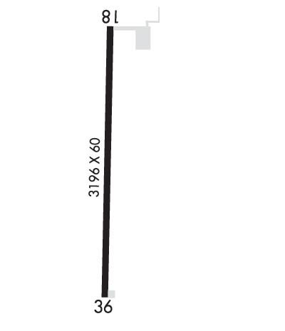
| Lat: N 3650.5 Long: W 08921.6 Elev: 313 Var: +02 Longest Runway: 3196 | ||
| CTAF: 122.9 | ||
| ||||||||||||||||||||||||||||||||
| ||||||||||||||||||||||||||||||||
| Rwy | Rwy | |||||||
| 3196x60 | 3196' | 3196x60 | 3196' | |||||
| Runway ID | Single Wheel | Double Wheel | Double Tandem Wheel | Dual Double Wheel |
| 18/36 | 12,500 | N/A | N/A | N/A |
| These numbers are Advisory and are not limits. The Airport Manager should have more accurate Weight Limits | ||||
 Airport Diagram might not be current. | |
| Facility Name: | MISSISSIPPI COUNTY |
| City Name: | CHARLESTON |
| County: | MISSISSIPPI |
| State abbrev: | MO |
| State Name: | MISSOURI |
| Ownership: | PUBLICLY OWNED |
| Use: | OPEN TO THE PUBLIC |
| Owner's Name: | MISSISSIPPI COUNTY COMMISSION |
| Address: | PO BOX 369 |
| CHARLESTON, MO 63834 | |
| Owner's Phone: | 573-683-2146 |
| Manager's Name: | MISSISSIPPI COUNTY COMMISSION |
| Address: | PO BOX 369 |
| CHARLESTON, MO 63834 | |
| Phone: | 573-683-2146 |
| FAA Region: | CENTRAL |
| FAA Field Office: | NONE |
| Date | Sunrise | Sunset |
|---|---|---|
| 09/24/21 Friday | 6:47 | 18:52 |
| 09/25/21 Saturday | 6:48 | 18:50 |
| 09/26/21 Sunday | 6:48 | 18:49 |
| 09/27/21 Monday | 6:49 | 18:47 |
| 09/28/21 Tuesday | 6:50 | 18:46 |
| 09/29/21 Wednesday | 6:51 | 18:44 |
| 09/30/21 Thursday | 6:52 | 18:43 |
| 10/01/21 Friday | 6:53 | 18:41 |
| 10/02/21 Saturday | 6:53 | 18:40 |
| 10/03/21 Sunday | 6:54 | 18:38 |
| 10/04/21 Monday | 6:55 | 18:37 |
| 10/05/21 Tuesday | 6:56 | 18:35 |
| 10/06/21 Wednesday | 6:57 | 18:34 |
| 10/07/21 Thursday | 6:58 | 18:32 |
| Airport Attendance Schedule | IRREGULAR |
| Airport Status | OPERATIONAL (This Status can change at any time - please check NOTAMS) |
| Airport Lighting Schedule | ACTVT REIL RWY 18 & 36; MIRL NSTD RWY 18/36 PRESET MED INTST; TO INCR INTST - CTAF. PAPI RWY 18 & 36 ON CONSLY. |
| Airport Storage Available | Tie Downs |
| Extra Services Available | Crop Dusting |
| Wind Indicator | YES - (lighted) |
| Control Tower | NO |
| CTAF Frequency | 122.900 |
| Unicom Frequency | |
| Rotating Beacon Color | CLEAR-GREEN (Light Land Airport) |
| Segmented Circle | YES |
| Landing Fee | NO |
| Airport Inspected | STATE - performed by STATE AERONAUTICAL PERSONNEL |
| Inspection Date | 06/15/2021 |
| Type of Fuel Available | None |
| Airframe Repair Service | None |
| Power Plant Repair Service | None |
| Latitude | N3650.5 |
| Longitude | W08921.6 (ESTIMATED) |
| Arpt Elevation | 313ft (SURVEYED) |
| Magnetic Variation | 02W |
| 4 miles S | of CHARLESTON |
| Traffic Pattern Altitude | |
| Sectional Chart | ST LOUIS |
| Operations (Reported) | Yearly | Avg. Daily |
|---|---|---|
| General Aviation Transient | 300 | 1 |
| General Aviation Local | 900 | 2 |
| Air Taxi | 0 | 0 |
| Commerical | 0 | 0 |
| Commuter | 0 | 0 |
| Military | 15 | 0 |
| Aircraft based on Field | |
|---|---|
| General Aviation Singles | 0 |
| General Aviation Multi | 0 |
| Jet Aircraft | 0 |
| General Aviation Helicopters | 0 |
| Military Aircraft | 0 |
| Gliders | 0 |
| Ultralights | 0 |
| FSS on field | NO |
| FSS tie-in | SAINT LOUIS |
| FSS Phone | 1-800-WX-BRIEF |
| Who issues Notams | STL |
| Notam D service at airport | YES |
| ARTCC Name | MEMPHIS |
| Airport Certification | |
| Aircraft Rescue & Firefighting Index | None |
| Airport of Entry | No |
| Custom Landing Rights | No |
| Joint Civil/Military | No |
| Military Landing rights | YES |
| GRANT AGREEMENTS UNDER FAAP/ADAP/AIP |
| ASSURANCES PURSUANT TO TITLE VI, CIVIL RIGHTS ACT OF 1964 |
| THIS AIRPORT HAS BEEN SURVEYED BY THE NATIONAL GEODETIC SURVEY. |
| ULTRALIGHT & CROP DUSTING ACFT ON & INVOF ARPT. |
| FOR CD CTC MEMPHIS ARTCC AT 901-368-8453/8449. |
| RWY 18/3 6 RWY 18/36 INCORRECT NUMBER OF THLD LGTS EACH RWY END. |
Airport Communications & Frequencies:
| |||||||
| Runway: 18 | Runway: 36 | ||
| Mag heading: | 182° | Mag heading: | 2° |
| Rwy Slope: | .00% | Rwy Slope: | .00% |
| Approach: | Approach: | ||
| Pattern: | Left Traffic | Pattern: | Left Traffic |
| Markings: | NONPRECISION INSTRUMENT | Markings: | NONPRECISION INSTRUMENT |
| Marking Condition: | POOR; RWY 18 MARKINGS FADED. | Marking Condition: | POOR; RWY 36 MARKINGS FADED. |
| Arresting Dev: | Arresting Dev: | ||
| Lat & Long: | N3650.8 W08921.6 | Lat. & Long.: | N3650.3 W08921.6 |
| Elev: | 313.0 ft. MSL | Elev: | 313.0 ft. MSL |
| TCH: | 40 ft. AGL | TCH: | 40 ft. AGL |
| Visual Glide Path: | 3.00 degrees | Visual Glide Path: | 3.00 degrees |
| Displaced Threshold: | No | Displaced Threshold: | No |
| Touchdown Zone: | YES | Touchdown Zone: | YES |
| Touchdown Elev.: | 313.0 feet | Touchdown Elev.: | 313.0 feet |
| Visual Glide Slope: | 2-Light PAPI on LEFT side of Runway | Visual Glide Slope: | 2-Light PAPI on LEFT side of Runway |
| RVR Equipment: | RVR Equipment: | ||
| RVV Equipment: | NO | RVV Equipment: | NO |
| Approach Lights: | Approach Lights: | ||
| REIL: | YES | REIL: | YES |
| Centerline Lights: | NO | Centerline Lights: | NO |
| Touchdown lights: | NO | Touchdown lights: | NO |
| Runway Category: | Runway with a Non-precision Approach | Runway Category: | Runway with a Non-precision Approach |
| Declared Distances: | Declared Distances: | ||
| Comments: | SMALL TREE 10 FT TALL 141 FT FM RWY 18 THLD, 90 FT RIGHT | Comments: |
Thanks for using FltPlan.com
all rights reserved © 1999-2021 by Flight Plan LLC
