
| LOVELL FIELD CHATTANOOGA TN |
| |
| Lat: N 3502.1 Long: W 08512.2 Elev: 683 Var: +05 Longest Runway: 7400 | ||
| Clr Del: 120.95 Dept. ATIS: 119.85 Arr. ATIS: 119.85 Ground: 121.7 Tower: 118.3 | ||
| ||||||||||||||||||||||||||||||||||||||||||||||||||||||||||||||||||||
| ||||||||||||||||||||||||||||||||||||||||||||||||||||||||||||||||||||
| ||||||||||||||||||||||||||||||||||||||||||||||||||||||||||||||||||||
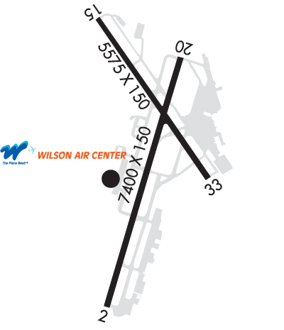
| Rwy | Rwy | |||||||
| 7400x150 | 7400' | 108.30 - 021° | 7400x150 | 7400' | 109.50 - 200° | |||
| 5575x150 | 5469' | 5575x150 | 5000' | |||||
| Runway ID | Single Wheel | Double Wheel | Double Tandem Wheel | Dual Double Wheel |
| 02/20 | 120,000 | 164,000 | 265,000 | N/A |
| 15/33 | 120,000 | 164,000 | 265,000 | N/A |
| These numbers are Advisory and are not limits. The Airport Manager should have more accurate Weight Limits | ||||
 Airport Diagram might not be current. | |
| Facility Name: | LOVELL FLD |
| City Name: | CHATTANOOGA |
| County: | HAMILTON |
| State abbrev: | TN |
| State Name: | TENNESSEE |
| Ownership: | PUBLICLY OWNED |
| Use: | OPEN TO THE PUBLIC |
| Owner's Name: | CHATTANOOGA METRO ARPT AUTH |
| Address: | 1001 AIRPORT ROAD, SUITE 14 |
| CHATTANOOGA, TN 37421 | |
| Owner's Phone: | 423-855-2200 |
| Manager's Name: | TERRY HART |
| Address: | 1001 AIRPORT ROAD, SUITE 14 |
| CHATTANOOGA, TN 37421 | |
| Phone: | 423-855-2200 |
| FAA Region: | SOUTHERN |
| FAA Field Office: | MEM |
| Date | Sunrise | Sunset |
|---|---|---|
| 09/24/21 Friday | 7:30 | 19:35 |
| 09/25/21 Saturday | 7:31 | 19:34 |
| 09/26/21 Sunday | 7:32 | 19:32 |
| 09/27/21 Monday | 7:32 | 19:31 |
| 09/28/21 Tuesday | 7:33 | 19:29 |
| 09/29/21 Wednesday | 7:34 | 19:28 |
| 09/30/21 Thursday | 7:35 | 19:26 |
| 10/01/21 Friday | 7:35 | 19:25 |
| 10/02/21 Saturday | 7:36 | 19:24 |
| 10/03/21 Sunday | 7:37 | 19:22 |
| 10/04/21 Monday | 7:38 | 19:21 |
| 10/05/21 Tuesday | 7:38 | 19:19 |
| 10/06/21 Wednesday | 7:39 | 19:18 |
| 10/07/21 Thursday | 7:40 | 19:17 |
| Airport Attendance Schedule | CONTINUOUS |
| Airport Status | OPERATIONAL (This Status can change at any time - please check NOTAMS) |
| Airport Lighting Schedule | WHEN ATCT CLOSED ACTVT MALSR RWY 02; TDZL RWY 20; CNTRLN LGTS RWY 02/20; PAPI RWY 02; HIRL RWY 02/20 - CTAF. WHEN ATCT CLSD MIRL RWY 15/33 UNAVBL; ALSF2 RWY 20 ON MED INTST. |
| Airport Storage Available | Tie Downs, Hanger |
| Extra Services Available | Air Freight, Avionics, Cargo Handling, Charter |
| Wind Indicator | YES - (lighted) |
| Control Tower | YES |
| CTAF Frequency | 118.300 |
| Unicom Frequency | 122.950 |
| Rotating Beacon Color | CLEAR-GREEN (Light Land Airport) |
| Segmented Circle | YES |
| Landing Fee | NO |
| Airport Inspected | FEDERAL - performed by FAA AIRPORTS FIELD PERSONNEL |
| Inspection Date | 06/27/2019 |
| Type of Fuel Available | Grade 100LL, JET A (freeze point -40C) |
| Airframe Repair Service | MAJOR |
| Power Plant Repair Service | MAJOR |
| Latitude | N3502.1 |
| Longitude | W08512.2 (ESTIMATED) |
| Arpt Elevation | 682ft (SURVEYED) |
| Magnetic Variation | 05W |
| 5 miles E | of CHATTANOOGA |
| Traffic Pattern Altitude | |
| Sectional Chart | ATLANTA |
| Operations (Reported) | Yearly | Avg. Daily |
|---|---|---|
| General Aviation Transient | 25892 | 71 |
| General Aviation Local | 4724 | 13 |
| Air Taxi | 14748 | 40 |
| Commerical | 8476 | 23 |
| Commuter | 0 | 0 |
| Military | 8919 | 24 |
| Aircraft based on Field | |
|---|---|
| General Aviation Singles | 29 |
| General Aviation Multi | 12 |
| Jet Aircraft | 46 |
| General Aviation Helicopters | 1 |
| Military Aircraft | 0 |
| Gliders | 0 |
| Ultralights | 0 |
| FSS on field | NO |
| FSS tie-in | NASHVILLE |
| FSS Phone | 1-800-WX-BRIEF |
| Who issues Notams | CHA |
| Notam D service at airport | YES |
| ARTCC Name | ATLANTA |
| Airport Certification | AIRPORT RECEIVING SCHEDULED AIR CARRIER SERVICE FROM CARRIERS CERTIFICATED BY THE CIVIL AERONAUTICS BOARD |
| Aircraft Rescue & Firefighting Index | AIRPORT HAS A CERTIFICATE UNDER CFR PART 139 |
| Airport of Entry | No |
| Custom Landing Rights | YES |
| Joint Civil/Military | No |
| Military Landing rights | YES |
| NATIONAL PLAN OF INTEGRATED AIRPORT SYSTEMS (NPIAS) |
| GRANT AGREEMENTS UNDER FAAP/ADAP/AIP |
| ADVANCE PLANNING AGREEMENT UNDER FAAP |
| ASSURANCES PURSUANT TO TITLE VI, CIVIL RIGHTS ACT OF 1964 |
| TSNT ACFT AVOID SCTY ZONE WI 300 FT OF TRML BLDG. |
| BIRDS INVOF ARPT. |
| HOLD SHORT INSTR READ BACK RQRD. |
| FOR CD IF UNA TO CTC ON FSS FREQ, CTC CHATTANOOGA APCH AT 423-855-6478, WHEN APCH CLSD CTC ATLANTA ARTCC AT 770-210-7692. |
Airport Communications & Frequencies:
| |||||||||||||||||||||||||||||||||||||||||||||||||||||
| Runway: 02 | Runway: 20 | ||
| Mag heading: | 22° | Mag heading: | 202° |
| Rwy Slope: | -.19% Down | Rwy Slope: | .19% Up |
| Approach: | ILS | Approach: | ILS |
| Pattern: | Left Traffic | Pattern: | Left Traffic |
| Markings: | PRECISION INSTRUMENT | Markings: | PRECISION INSTRUMENT |
| Marking Condition: | GOOD | Marking Condition: | GOOD |
| Arresting Dev: | Arresting Dev: | ||
| Lat & Long: | N3501.4 W08512.5 | Lat. & Long.: | N3502.5 W08512.0 |
| Elev: | 681.3 ft. MSL | Elev: | 667.1 ft. MSL |
| TCH: | 71 ft. AGL | TCH: | |
| Visual Glide Path: | 3.00 degrees | Visual Glide Path: | |
| Displaced Threshold: | No | Displaced Threshold: | No |
| Touchdown Zone: | YES | Touchdown Zone: | YES |
| Touchdown Elev.: | 682.5 feet | Touchdown Elev.: | 673.1 feet |
| Visual Glide Slope: | 4-Light PAPI on RIGHT side of Runway | Visual Glide Slope: | |
| RVR Equipment: | TOUCHDOWN-ROLLOUT | RVR Equipment: | TOUCHDOWN-ROLLOUT |
| RVV Equipment: | NO | RVV Equipment: | NO |
| Approach Lights: | MALSR - 1,400 foot medium intensity approach lighting system with runway alignment indicator lights | Approach Lights: | ALSF2 - standard 2,400 foot high intensity approach lighting system with sequenced flashers, Category II or III |
| REIL: | NO | REIL: | NO |
| Centerline Lights: | YES | Centerline Lights: | YES |
| Touchdown lights: | NO | Touchdown lights: | YES |
| Runway Category: | Precision Instrument Runway | Runway Category: | Precision Instrument Runway |
| Declared Distances: | TORA:7400' TODA:7400' ASDA:7100' LDA:7100' | Declared Distances: | TORA:7400' TODA:7400' ASDA:7400' LDA:7400' |
| Obstructions: | Obstructions: | RR | |
| Marked: | Marked: | NOT Marked/Lighted | |
| Clearance slope: | 50:1 | Clearance slope: | 23:1 |
| Obstruction height: | Obstruction height: | 28 feet AGL | |
| Dist. from runway: | Dist. from runway: | 850 feet | |
| Centerline offset: | Centerline offset: | 600 feet left of centerline | |
| Comments: | Comments: |
| Runway: 15 | Runway: 33 | ||
| Mag heading: | 150° | Mag heading: | 330° |
| Rwy Slope: | .08% Up | Rwy Slope: | -.08% Down |
| Approach: | Approach: | ||
| Pattern: | Left Traffic | Pattern: | Left Traffic |
| Markings: | NONPRECISION INSTRUMENT | Markings: | NONPRECISION INSTRUMENT |
| Marking Condition: | GOOD | Marking Condition: | GOOD |
| Arresting Dev: | Arresting Dev: | ||
| Lat & Long: | N3502.7 W08512.5 | Lat. & Long.: | N3502.0 W08511.9 |
| Elev: | 670.6 ft. MSL | Elev: | 674.9 ft. MSL |
| TCH: | 45 ft. AGL | TCH: | 40 ft. AGL |
| Visual Glide Path: | 3.00 degrees | Visual Glide Path: | 3.00 degrees |
| Displaced Threshold: | 106 feet | Displaced Threshold: | 575 feet |
| Touchdown Zone: | YES | Touchdown Zone: | YES |
| Touchdown Elev.: | 670.6 feet | Touchdown Elev.: | 671.6 feet |
| Visual Glide Slope: | 4-Light PAPI on LEFT side of Runway | Visual Glide Slope: | 4-Light PAPI on LEFT side of Runway |
| RVR Equipment: | RVR Equipment: | ||
| RVV Equipment: | NO | RVV Equipment: | NO |
| Approach Lights: | Approach Lights: | ||
| REIL: | NO | REIL: | NO |
| Centerline Lights: | NO | Centerline Lights: | NO |
| Touchdown lights: | NO | Touchdown lights: | NO |
| Runway Category: | Runway with a Non-precision Approach having visibility minimums greater than 3/4 mile | Runway Category: | Runway with a Non-precision Approach having visibility minimums greater than 3/4 mile |
| Declared Distances: | TORA:5575' TODA:5575' ASDA:5575' LDA:5470' | Declared Distances: | TORA:5470' TODA:5470' ASDA:5470' LDA:5000' |
| Obstructions: | TREES | Obstructions: | TREES |
| Marked: | NOT Marked/Lighted | Marked: | NOT Marked/Lighted |
| Clearance slope: | 17:1; APCH SLOPE 25:1 TO DSPLCD THR. | Clearance slope: | 18:1; APCH SLOPE 25:1 TO DSPLCD THR. |
| Obstruction height: | 3 feet AGL | Obstruction height: | 44 feet AGL |
| Dist. from runway: | 1000 feet | Dist. from runway: | 1000 feet |
| Centerline offset: | 100 left of centerline | Centerline offset: | 325 feet left of centerline |
| Comments: | Comments: |
Thanks for using FltPlan.com
all rights reserved © 1999-2021 by Flight Plan LLC