
| COLLEGE PARK COLLEGE PARK MD |
| |
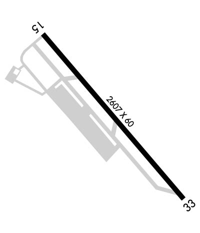
| Lat: N 3858.8 Long: W 07655.3 Elev: 49 Var: +11 Longest Runway: 2980 | ||
| AWOS: 121.22 CTAF: 122.97 | ||
| ||||||||||||||||||||||||||||||||||||||||||||
| ||||||||||||||||||||||||||||||||||||||||||||
| ||||||||||||||||||||||||||||||||||||||||||||
| Rwy | Rwy | |||||||
| 2980x60 | 2416' | 2980x60 | 2809' | |||||
| Runway ID | Single Wheel | Double Wheel | Double Tandem Wheel | Dual Double Wheel |
| 15/33 | N/A | N/A | N/A | N/A |
| These numbers are Advisory and are not limits. The Airport Manager should have more accurate Weight Limits | ||||
 Airport Diagram might not be current. | |
| Facility Name: | COLLEGE PARK |
| City Name: | COLLEGE PARK |
| County: | PRINCE GEORGES |
| State abbrev: | MD |
| State Name: | MARYLAND |
| Ownership: | PUBLICLY OWNED |
| Use: | OPEN TO THE PUBLIC |
| Owner's Name: | MNCPPC; THE MARYLAND NATIONAL CAPITAL PARK & PLANNING CMSN. |
| Address: | 6611 KENILWORTH AVENUE |
| RIVERDALE, MD 20737 | |
| Owner's Phone: | 301-699-2255 |
| Manager's Name: | DREW MYERS |
| Address: | 1909 CORPORAL FRANK SCOTT DRIVE |
| COLLEGE PARK, MD 20740 | |
| Phone: | 301-864-5844 |
| FAA Region: | EASTERN |
| FAA Field Office: | DCA |
| Date | Sunrise | Sunset |
|---|---|---|
| 06/08/26 Monday | 5:42 | 20:32 |
| 06/09/26 Tuesday | 5:42 | 20:32 |
| 06/10/26 Wednesday | 5:42 | 20:33 |
| 06/11/26 Thursday | 5:42 | 20:33 |
| 06/12/26 Friday | 5:41 | 20:34 |
| 06/13/26 Saturday | 5:41 | 20:34 |
| 06/14/26 Sunday | 5:41 | 20:34 |
| 06/15/26 Monday | 5:41 | 20:35 |
| 06/16/26 Tuesday | 5:41 | 20:35 |
| 06/17/26 Wednesday | 5:42 | 20:36 |
| 06/18/26 Thursday | 5:42 | 20:36 |
| 06/19/26 Friday | 5:42 | 20:36 |
| 06/20/26 Saturday | 5:42 | 20:36 |
| 06/21/26 Sunday | 5:42 | 20:37 |
| Airport Attendance Schedule | 7 Days A Week 0700-2200 |
| Airport Status | OPERATIONAL (This Status can change at any time - please check NOTAMS) |
| Airport Lighting Schedule | ACTVT REIL RWY 15 & 33; PAPI RWY 15 & 33; MIRL RWY 15/33 - CTAF. |
| Airport Storage Available | Tie Downs |
| Extra Services Available | NONE |
| Wind Indicator | YES - (lighted) |
| Control Tower | NO |
| CTAF Frequency | 122.975 |
| Unicom Frequency | 122.975 |
| Rotating Beacon Color | WG |
| Segmented Circle | YES |
| Landing Fee | NO |
| Airport Inspected | STATE - performed by STATE AERONAUTICAL PERSONNEL |
| Inspection Date | 09/09/2025 |
| Type of Fuel Available | Grade 100LL, JET A-1 (icing inhibitor, freeze point -50C) |
| Airframe Repair Service | NONE |
| Power Plant Repair Service | NONE |
| Latitude | N3858.8 |
| Longitude | W07655.3 (ESTIMATED) |
| Arpt Elevation | 48ft (SURVEYED) |
| Magnetic Variation | 11W |
| 1 miles SE | of COLLEGE PARK |
| Traffic Pattern Altitude | |
| Sectional Chart | WASHINGTON |
| Operations (Reported) | Yearly | Avg. Daily |
|---|---|---|
| General Aviation Transient | 0 | 0 |
| General Aviation Local | 0 | 0 |
| Air Taxi | 0 | 0 |
| Commerical | 0 | 0 |
| Commuter | 0 | 0 |
| Military | 0 | 0 |
| Aircraft based on Field | |
|---|---|
| General Aviation Singles | 0 |
| General Aviation Multi | 0 |
| Jet Aircraft | 0 |
| General Aviation Helicopters | 0 |
| Military Aircraft | 0 |
| Gliders | 0 |
| Ultralights | 0 |
| FSS on field | NO |
| FSS tie-in | LEESBURG |
| FSS Phone | 1-800-WX-BRIEF |
| Who issues Notams | CGS |
| Notam D service at airport | YES |
| ARTCC Name | WASHINGTON |
| Airport Certification | |
| Aircraft Rescue & Firefighting Index | None |
| Airport of Entry | No |
| Custom Landing Rights | No |
| Joint Civil/Military | No |
| Military Landing rights | No |
| NATIONAL PLAN OF INTEGRATED AIRPORT SYSTEMS (NPIAS) |
| GRANT AGREEMENTS UNDER FAAP/ADAP/AIP |
| ASSURANCES PURSUANT TO TITLE VI, CIVIL RIGHTS ACT OF 1964 |
| NO TKOFS 2200-0700; LNDG ONLY. |
| TSNT PRKG: FIRST 4 HRS FREE; FEE AFT, WAIVED W/MIN FUEL PURCHASE; OVNGT FEE. |
| HEL RAMP FEE; WAIVED IF UNDER 3500 LBS OR MIN FUEL PURCHASE. |
| ACFT HANDLING FEE IF RELOCATION TO/FROM FUEL AREA RQRD BY ARPT PSNL. |
| BLDG 0.1 NM S OF ARPT 23 FT AGL LGTD. |
| NO ACFT OVR 12500 LBS MFR GWT; HELS ONLY WITH 24 HR PPR - CALL AMGR 301-864-5844. |
| NOISE ABATEMENT PROCEDURES IN EFFECT CTC AMGR 301-864-5844. |
| AER 15 HEAVY SMOKE & FIREFIGHTING TRAINING OPNS INTERMITTENTLY IN PROGRESS. |
| NO STUDENT TGL OR SOLO OPNS PERMITTED. |
| DEER AND OTHER WILDLIFE ON & INVOF ARPT. |
| COMPLIANCE WITH 14CFR SECTION 93.335 IS REQUIRED BEFORE PILOTS MAY OPERATE TO/FROM THIS AIRPORT. |
| FOR CD CTC POTOMAC APCH AT 866-599-3874. |
Airport Communications & Frequencies:
| ||||||||||||||||||||||
| Runway: 15 | Runway: 33 | ||
| Mag heading: | 149° | Mag heading: | 329° |
| Rwy Slope: | -.35% Down | Rwy Slope: | .35% Up |
| Approach: | Approach: | ||
| Pattern: | Left Traffic | Pattern: | Left Traffic |
| Markings: | NONPRECISION INSTRUMENT | Markings: | NONPRECISION INSTRUMENT |
| Marking Condition: | GOOD | Marking Condition: | GOOD |
| Arresting Dev: | Arresting Dev: | ||
| Lat & Long: | N3859.0 W07655.5 | Lat. & Long.: | N3858.6 W07655.1 |
| Elev: | 48.9 ft. MSL | Elev: | 38.5 ft. MSL |
| TCH: | 27 ft. AGL | TCH: | 27 ft. AGL |
| Visual Glide Path: | 4.00 degrees | Visual Glide Path: | 4.00 degrees |
| Displaced Threshold: | 564 feet | Displaced Threshold: | 171 feet |
| Touchdown Zone: | YES | Touchdown Zone: | YES |
| Touchdown Elev.: | 47.1 feet | Touchdown Elev.: | 48.9 feet |
| Visual Glide Slope: | 2-Light PAPI on LEFT side of Runway | Visual Glide Slope: | 2-Light PAPI on RIGHT side of Runway |
| RVR Equipment: | RVR Equipment: | ||
| RVV Equipment: | NO | RVV Equipment: | NO |
| Approach Lights: | Approach Lights: | ||
| REIL: | YES | REIL: | YES |
| Centerline Lights: | NO | Centerline Lights: | NO |
| Touchdown lights: | NO | Touchdown lights: | NO |
| Runway Category: | Runway with a Visual Approach | Runway Category: | Runway with a Visual Approach |
| Declared Distances: | TORA:2980' TODA:2980' ASDA:2740' LDA:2176' | Declared Distances: | TORA:2980' TODA:2980' ASDA:2846' LDA:2675' |
| Obstructions: | TREES | Obstructions: | TREES |
| Marked: | NOT Marked/Lighted | Marked: | NOT Marked/Lighted |
| Clearance slope: | 3:1; APCH SLOPE AT CL 20:1 FM DSPLCD THR AND CENTERLINE. | Clearance slope: | 13:1 |
| Obstruction height: | 32 feet AGL | Obstruction height: | 64 feet AGL |
| Dist. from runway: | 322 feet | Dist. from runway: | 1086 feet |
| Centerline offset: | 51 right of centerline | Centerline offset: | 172 feet left of centerline |
| Comments: | +33 FT RAILROAD, 117 FM THR WITH OBS LTS. | Comments: | +15 FT FENCE 87 FT R AT THR; -6 FT DITCH 65 FT L AT THR. |
Thanks for using FltPlan.com
all rights reserved © 1999-2026 by Flight Plan LLC
