
| CAPE GIRARDEAU RGNL CAPE GIRARDEAU MO |
| |
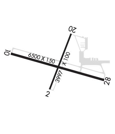
| Lat: N 3713.5 Long: W 08934.2 Elev: 342 Var: +02 Longest Runway: 6500 | ||
| AWOS: 120.55 Ground: 121.6 Tower: 125.52 | ||
| ||||||||||||||||||||||||||||||||||||||||||||
| ||||||||||||||||||||||||||||||||||||||||||||
| ||||||||||||||||||||||||||||||||||||||||||||
| Rwy | Rwy | |||||||
| 3997x100 | 3997' | 3997x100 | 3997' | |||||
| 6500x150 | 6500' | 109.50 - 107° | 6500x150 | 6500' | ||||
| Runway ID | Single Wheel | Double Wheel | Double Tandem Wheel | Dual Double Wheel |
| 02/20 | 45,000 | 60,000 | 100,000 | N/A |
| 10/28 | 93,000 | 125,000 | 215,000 | N/A |
| These numbers are Advisory and are not limits. The Airport Manager should have more accurate Weight Limits | ||||
 Airport Diagram might not be current. | |
| Facility Name: | CAPE GIRARDEAU RGNL |
| City Name: | CAPE GIRARDEAU |
| County: | SCOTT |
| State abbrev: | MO |
| State Name: | MISSOURI |
| Ownership: | PUBLICLY OWNED |
| Use: | OPEN TO THE PUBLIC |
| Owner's Name: | CITY OF CAPE GIRARDEAU |
| Address: | CITY HALL, 401 INDEPENDENCE |
| CAPE GIRARDEAU, MO 63701 | |
| Owner's Phone: | 573-334-1212 |
| Manager's Name: | MS. KATRINA D. AMOS |
| Address: | PO BOX 617 |
| CAPE GIRARDEAU, MO 63702 | |
| Phone: | 573-334-6230 |
| FAA Region: | CENTRAL |
| FAA Field Office: | NONE |
| Date | Sunrise | Sunset |
|---|---|---|
| 09/24/21 Friday | 6:48 | 18:52 |
| 09/25/21 Saturday | 6:48 | 18:51 |
| 09/26/21 Sunday | 6:49 | 18:49 |
| 09/27/21 Monday | 6:50 | 18:48 |
| 09/28/21 Tuesday | 6:51 | 18:46 |
| 09/29/21 Wednesday | 6:52 | 18:45 |
| 09/30/21 Thursday | 6:53 | 18:43 |
| 10/01/21 Friday | 6:53 | 18:42 |
| 10/02/21 Saturday | 6:54 | 18:40 |
| 10/03/21 Sunday | 6:55 | 18:39 |
| 10/04/21 Monday | 6:56 | 18:37 |
| 10/05/21 Tuesday | 6:57 | 18:36 |
| 10/06/21 Wednesday | 6:58 | 18:34 |
| 10/07/21 Thursday | 6:59 | 18:33 |
| Airport Attendance Schedule | DAILY 0600-1800, SUN 0600-1800 |
| Airport Status | OPERATIONAL (This Status can change at any time - please check NOTAMS) |
| Airport Lighting Schedule | ACTVT MIRL RY 02/20 & HIRL RY 10/28; MALSR RY 10 AND ODALS RY 28 - CTAF. |
| Airport Storage Available | Tie Downs, Hanger |
| Extra Services Available | Air Freight, Avionics, Charter, Flight Instruction, Aircraft Rental, Aircraft Sales |
| Wind Indicator | YES - (lighted) |
| Control Tower | YES |
| CTAF Frequency | 125.525 |
| Unicom Frequency | 122.950 |
| Rotating Beacon Color | CLEAR-GREEN (Light Land Airport) |
| Segmented Circle | NO |
| Landing Fee | NO |
| Airport Inspected | FEDERAL - performed by FAA AIRPORTS FIELD PERSONNEL |
| Inspection Date | 10/16/2019 |
| Type of Fuel Available | Grade 100LL, JET A (freeze point -40C) |
| Airframe Repair Service | MAJOR |
| Power Plant Repair Service | MAJOR |
| Latitude | N3713.5 |
| Longitude | W08934.2 (ESTIMATED) |
| Arpt Elevation | 341ft (SURVEYED) |
| Magnetic Variation | 02W |
| 5 miles SW | of CAPE GIRARDEAU |
| Traffic Pattern Altitude | |
| Sectional Chart | ST LOUIS |
| Operations (Reported) | Yearly | Avg. Daily |
|---|---|---|
| General Aviation Transient | 12286 | 34 |
| General Aviation Local | 10556 | 29 |
| Air Taxi | 1415 | 4 |
| Commerical | 0 | 0 |
| Commuter | 0 | 0 |
| Military | 218 | 1 |
| Aircraft based on Field | |
|---|---|
| General Aviation Singles | 45 |
| General Aviation Multi | 7 |
| Jet Aircraft | 4 |
| General Aviation Helicopters | 5 |
| Military Aircraft | 0 |
| Gliders | 0 |
| Ultralights | 0 |
| FSS on field | NO |
| FSS tie-in | SAINT LOUIS |
| FSS Phone | 1-800-WX-BRIEF |
| Who issues Notams | CGI |
| Notam D service at airport | YES |
| ARTCC Name | MEMPHIS |
| Airport Certification | AIRPORT RECEIVING SCHEDULED AIR CARRIER SERVICE FROM CARRIERS CERTIFICATED BY THE CIVIL AERONAUTICS BOARD; RWY 02/20 NOT AVBL FOR SCHEDULED ACR OPNS WITH MORE THAN 9 PSGR SEATS OR UNSCHEDULED ACR AT LEAST 31 PSGR SEATS |
| Aircraft Rescue & Firefighting Index | AIRPORT HAS A CERTIFICATE UNDER CFR PART 139 |
| Airport of Entry | No |
| Custom Landing Rights | No |
| Joint Civil/Military | No |
| Military Landing rights | YES |
| NATIONAL PLAN OF INTEGRATED AIRPORT SYSTEMS (NPIAS) |
| GRANT AGREEMENTS UNDER FAAP/ADAP/AIP |
| SURPLUS PROPERTY AGREEMENT UNDER REGULATION 16-WAA |
| ASSURANCES PURSUANT TO TITLE VI, CIVIL RIGHTS ACT OF 1964 |
| (E110) STANDBY GEN FOR FAA FAC ONLY |
| NORTHERN 100 FT TWY 'C' NOT VISIBLE FM CONTROL TOWER. |
| FOR CD CTC MEMPHIS ARTCC AT 901-368-8453/8449. |
Airport Communications & Frequencies:
| |||||||||||||
| Runway: 02 | Runway: 20 | ||
| Mag heading: | 23° | Mag heading: | 203° |
| Rwy Slope: | -.14% Down | Rwy Slope: | .14% Up |
| Approach: | Approach: | ||
| Pattern: | Left Traffic | Pattern: | Left Traffic |
| Markings: | NONPRECISION INSTRUMENT | Markings: | NONPRECISION INSTRUMENT |
| Marking Condition: | GOOD | Marking Condition: | GOOD |
| Arresting Dev: | Arresting Dev: | ||
| Lat & Long: | N3713.2 W08934.4 | Lat. & Long.: | N3713.9 W08934.1 |
| Elev: | 341.6 ft. MSL | Elev: | 335.9 ft. MSL |
| TCH: | 52 ft. AGL | TCH: | 43 ft. AGL |
| Visual Glide Path: | 4.00 degrees | Visual Glide Path: | 3.00 degrees |
| Displaced Threshold: | No | Displaced Threshold: | No |
| Touchdown Zone: | YES | Touchdown Zone: | YES |
| Touchdown Elev.: | 341.6 feet | Touchdown Elev.: | 338.7 feet |
| Visual Glide Slope: | 4-BOX VASI ON LEFT SIDE OF RUNWAY | Visual Glide Slope: | 4-BOX VASI ON LEFT SIDE OF RUNWAY |
| RVR Equipment: | RVR Equipment: | ||
| RVV Equipment: | NO | RVV Equipment: | NO |
| Approach Lights: | Approach Lights: | ||
| REIL: | NO | REIL: | NO |
| Centerline Lights: | NO | Centerline Lights: | NO |
| Touchdown lights: | NO | Touchdown lights: | NO |
| Runway Category: | Runway with a Non-precision Approach having visibility minimums greater than 3/4 mile | Runway Category: | Runway with a Non-precision Approach having visibility minimums greater than 3/4 mile |
| Declared Distances: | TORA:3996' TODA:3996' ASDA:3996' LDA:3996' | Declared Distances: | TORA:3996' TODA:3996' ASDA:3996' LDA:3996' |
| Obstructions: | TREE | Obstructions: | |
| Marked: | NOT Marked/Lighted | Marked: | |
| Clearance slope: | 18:1 | Clearance slope: | 50:1 |
| Obstruction height: | 70 feet AGL | Obstruction height: | |
| Dist. from runway: | 1500 feet | Dist. from runway: | |
| Centerline offset: | 450 left of centerline | Centerline offset: | |
| Comments: | Comments: |
| Runway: 10 | Runway: 28 | ||
| Mag heading: | 108° | Mag heading: | 288° |
| Rwy Slope: | .06% Up | Rwy Slope: | -.06% Down |
| Approach: | ILS/DME | Approach: | |
| Pattern: | Left Traffic | Pattern: | Left Traffic |
| Markings: | PRECISION INSTRUMENT | Markings: | NONPRECISION INSTRUMENT |
| Marking Condition: | GOOD | Marking Condition: | GOOD |
| Arresting Dev: | Arresting Dev: | ||
| Lat & Long: | N3713.6 W08934.9 | Lat. & Long.: | N3713.4 W08933.6 |
| Elev: | 337.1 ft. MSL | Elev: | 340.8 ft. MSL |
| TCH: | TCH: | 38 ft. AGL | |
| Visual Glide Path: | Visual Glide Path: | 3.00 degrees | |
| Displaced Threshold: | No | Displaced Threshold: | No |
| Touchdown Zone: | YES | Touchdown Zone: | YES |
| Touchdown Elev.: | 337.3 feet | Touchdown Elev.: | 340.8 feet |
| Visual Glide Slope: | Visual Glide Slope: | 2-Box VASI on LEFT side of Runway | |
| RVR Equipment: | TOUCHDOWN | RVR Equipment: | ROLLOUT |
| RVV Equipment: | NO | RVV Equipment: | NO |
| Approach Lights: | MALSR - 1,400 foot medium intensity approach lighting system with runway alignment indicator lights | Approach Lights: | ODALS - omnidirectional approach lighting system |
| REIL: | NO | REIL: | NO |
| Centerline Lights: | NO | Centerline Lights: | NO |
| Touchdown lights: | NO | Touchdown lights: | NO |
| Runway Category: | Precision Instrument Runway | Runway Category: | D |
| Declared Distances: | TORA:6499' TODA:6499' ASDA:6499' LDA:6499' | Declared Distances: | TORA:6499' TODA:6499' ASDA:6499' LDA:6499' |
| Obstructions: | Obstructions: | TREE | |
| Marked: | Marked: | NOT Marked/Lighted | |
| Clearance slope: | 50:1 | Clearance slope: | 33:1 |
| Obstruction height: | Obstruction height: | 160 feet AGL | |
| Dist. from runway: | Dist. from runway: | 5600 feet | |
| Centerline offset: | Centerline offset: | 1100 feet right of centerline | |
| Comments: | Comments: |
Thanks for using FltPlan.com
all rights reserved © 1999-2021 by Flight Plan LLC
