
| GREENLEE COUNTY CLIFTON/MORENCI AZ |
| |
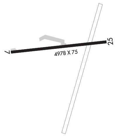
| Lat: N 3257.4 Long: W 10912.7 Elev: 3798 Var: -10 Longest Runway: 4978 | ||
| AWOS: 119.05 CTAF: 122.9 | ||
| ||||||||||||||||||||||||||||||||
| ||||||||||||||||||||||||||||||||
| ||||||||||||||||||||||||||||||||
| Rwy | Rwy | |||||||
| 4978x75 | 4978' | 4978x75 | 4978' | |||||
| Runway ID | Single Wheel | Double Wheel | Double Tandem Wheel | Dual Double Wheel |
| 07/25 | 21,000 | N/A | N/A | N/A |
| These numbers are Advisory and are not limits. The Airport Manager should have more accurate Weight Limits | ||||
 Airport Diagram might not be current. | |
| Facility Name: | GREENLEE COUNTY |
| City Name: | CLIFTON/MORENCI |
| County: | GREENLEE |
| State abbrev: | AZ |
| State Name: | ARIZONA |
| Ownership: | PUBLICLY OWNED |
| Use: | OPEN TO THE PUBLIC |
| Owner's Name: | GREENLEE COUNTY |
| Address: | COURTHOUSE, BOX 908 |
| CLIFTON, AZ 85533 | |
| Owner's Phone: | 928-865-2072 |
| Manager's Name: | REED LARSON |
| Address: | PO BOX 908 |
| CLIFTON, AZ 85533 | |
| Phone: | 928-865-4762 |
| FAA Region: | WESTERN-PACIFIC |
| FAA Field Office: | PHX |
| Date | Sunrise | Sunset |
|---|---|---|
| 06/08/26 Monday | 5:08 | 19:24 |
| 06/09/26 Tuesday | 5:08 | 19:24 |
| 06/10/26 Wednesday | 5:08 | 19:25 |
| 06/11/26 Thursday | 5:08 | 19:25 |
| 06/12/26 Friday | 5:08 | 19:26 |
| 06/13/26 Saturday | 5:08 | 19:26 |
| 06/14/26 Sunday | 5:08 | 19:26 |
| 06/15/26 Monday | 5:08 | 19:27 |
| 06/16/26 Tuesday | 5:08 | 19:27 |
| 06/17/26 Wednesday | 5:08 | 19:27 |
| 06/18/26 Thursday | 5:08 | 19:28 |
| 06/19/26 Friday | 5:08 | 19:28 |
| 06/20/26 Saturday | 5:08 | 19:28 |
| 06/21/26 Sunday | 5:09 | 19:28 |
| Airport Attendance Schedule | UNATTENDED |
| Airport Status | OPERATIONAL (This Status can change at any time - please check NOTAMS) |
| Airport Lighting Schedule | ACTVT MIRL RWY 07/25 - CTAF. PAPI RWY 07 & 25 OPR CONSLY. |
| Airport Storage Available | Tie Downs |
| Extra Services Available | NONE |
| Wind Indicator | YES - (lighted) |
| Control Tower | NO |
| CTAF Frequency | 122.900 |
| Unicom Frequency | |
| Rotating Beacon Color | WG |
| Segmented Circle | YES |
| Landing Fee | NO |
| Airport Inspected | STATE - performed by PRIVATE CONTRACT PERSONNEL |
| Inspection Date | 04/22/2024 |
| Type of Fuel Available | None |
| Airframe Repair Service | None |
| Power Plant Repair Service | None |
| Latitude | N3257.4 |
| Longitude | W10912.7 (ESTIMATED) |
| Arpt Elevation | 3797ft (SURVEYED) |
| Magnetic Variation | 10E |
| 8 miles SE | of CLIFTON/MORENCI |
| Traffic Pattern Altitude | |
| Sectional Chart | PHOENIX |
| Operations (Reported) | Yearly | Avg. Daily |
|---|---|---|
| General Aviation Transient | 0 | 0 |
| General Aviation Local | 0 | 0 |
| Air Taxi | 0 | 0 |
| Commerical | 0 | 0 |
| Commuter | 0 | 0 |
| Military | 0 | 0 |
| Aircraft based on Field | |
|---|---|
| General Aviation Singles | 0 |
| General Aviation Multi | 0 |
| Jet Aircraft | 0 |
| General Aviation Helicopters | 0 |
| Military Aircraft | 0 |
| Gliders | 0 |
| Ultralights | 0 |
| FSS on field | NO |
| FSS tie-in | PRESCOTT |
| FSS Phone | 1-800-WX-BRIEF |
| Who issues Notams | PRC |
| Notam D service at airport | YES |
| ARTCC Name | ALBUQUERQUE |
| Airport Certification | |
| Aircraft Rescue & Firefighting Index | None |
| Airport of Entry | No |
| Custom Landing Rights | No |
| Joint Civil/Military | No |
| Military Landing rights | YES |
| NATIONAL PLAN OF INTEGRATED AIRPORT SYSTEMS (NPIAS) |
| GRANT AGREEMENTS UNDER FAAP/ADAP/AIP |
| CONVEYANCE UNDER SCETION 16, FEDERAL AIRPORT ACT OF 1946 OR SECTION 23, AIRPORT AND AIRWAY DEVELOPMENT ACT OF 1970 |
| ASSURANCES PURSUANT TO TITLE VI, CIVIL RIGHTS ACT OF 1964 |
| PAEW MOWING CONS. |
| DEER ON OR INVOF ARPT. |
| FOR CD CTC ALBUQUERQUE ARTCC AT 505-856-4861. |
Airport Communications & Frequencies:
| |||||||
| Runway: 07 | Runway: 25 | ||
| Mag heading: | 74° | Mag heading: | 254° |
| Rwy Slope: | 1.50% Up | Rwy Slope: | -1.50% Down |
| Approach: | Approach: | ||
| Pattern: | Left Traffic | Pattern: | Left Traffic |
| Markings: | NONPRECISION INSTRUMENT | Markings: | NONPRECISION INSTRUMENT |
| Marking Condition: | GOOD | Marking Condition: | GOOD |
| Arresting Dev: | Arresting Dev: | ||
| Lat & Long: | N3257.4 W10913.2 | Lat. & Long.: | N3257.5 W10912.2 |
| Elev: | 3722.2 ft. MSL | Elev: | 3797.1 ft. MSL |
| TCH: | 40 ft. AGL | TCH: | 40 ft. AGL |
| Visual Glide Path: | 3.00 degrees | Visual Glide Path: | 3.00 degrees |
| Displaced Threshold: | No | Displaced Threshold: | No |
| Touchdown Zone: | YES | Touchdown Zone: | YES |
| Touchdown Elev.: | 3767.3 feet | Touchdown Elev.: | 3797.1 feet |
| Visual Glide Slope: | 2-Light PAPI on LEFT side of Runway | Visual Glide Slope: | 2-Light PAPI on LEFT side of Runway |
| RVR Equipment: | RVR Equipment: | ||
| RVV Equipment: | NO | RVV Equipment: | NO |
| Approach Lights: | Approach Lights: | ||
| REIL: | NO | REIL: | NO |
| Centerline Lights: | NO | Centerline Lights: | NO |
| Touchdown lights: | NO | Touchdown lights: | NO |
| Runway Category: | Runway with a Visual Approach | Runway Category: | Runway with a Visual Approach |
| Declared Distances: | Declared Distances: | ||
| Comments: | 4-6 FT BRUSH 110 FT FM THR, 95 FT L OF CNTRLN. | Comments: |
Thanks for using FltPlan.com
all rights reserved © 1999-2026 by Flight Plan LLC
