
| COULTER FIELD BRYAN TX |
| |
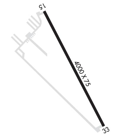
| Lat: N 3042.9 Long: W 09619.9 Elev: 367 Var: -04 Longest Runway: 4000 | ||
| AWOS: 125.97 CTAF: 123.0 | ||
| ||||||
| ||||||
|
| Rwy | Rwy | |||||||
| 4000x75 | 4000' | 4000x75 | 4000' | |||||
| Runway ID | Single Wheel | Double Wheel | Double Tandem Wheel | Dual Double Wheel |
| 15/33 | N/A | N/A | N/A | N/A |
| These numbers are Advisory and are not limits. The Airport Manager should have more accurate Weight Limits | ||||
 Airport Diagram might not be current. | |
| Facility Name: | COULTER FLD |
| City Name: | BRYAN |
| County: | BRAZOS |
| State abbrev: | TX |
| State Name: | TEXAS |
| Ownership: | PUBLICLY OWNED |
| Use: | OPEN TO THE PUBLIC |
| Owner's Name: | CITY OF BRYAN |
| Address: | P. O. BOX 1000 |
| BRYAN, TX 77803 | |
| Owner's Phone: | 979-209-5030 |
| Manager's Name: | BRANDON REID |
| Address: | 6120 SH 21E |
| BRYAN, TX 77808 | |
| Phone: | (979) 209-5231 |
| FAA Region: | SOUTHWEST |
| FAA Field Office: | TEX |
| Date | Sunrise | Sunset |
|---|---|---|
| 09/24/21 Friday | 7:15 | 19:20 |
| 09/25/21 Saturday | 7:15 | 19:18 |
| 09/26/21 Sunday | 7:16 | 19:17 |
| 09/27/21 Monday | 7:16 | 19:16 |
| 09/28/21 Tuesday | 7:17 | 19:15 |
| 09/29/21 Wednesday | 7:18 | 19:13 |
| 09/30/21 Thursday | 7:18 | 19:12 |
| 10/01/21 Friday | 7:19 | 19:11 |
| 10/02/21 Saturday | 7:19 | 19:10 |
| 10/03/21 Sunday | 7:20 | 19:08 |
| 10/04/21 Monday | 7:21 | 19:07 |
| 10/05/21 Tuesday | 7:21 | 19:06 |
| 10/06/21 Wednesday | 7:22 | 19:05 |
| 10/07/21 Thursday | 7:22 | 19:03 |
| Airport Attendance Schedule | SAT-SUN UNATNDD, MON-FRI 0800-1600 |
| Airport Status | OPERATIONAL (This Status can change at any time - please check NOTAMS) |
| Airport Lighting Schedule | DUSK-DAWN. MIRL RWY 15/33 PRESET LOW INTST; TO INCR INTST - CTAF. |
| Airport Storage Available | Tie Downs |
| Extra Services Available | NONE |
| Wind Indicator | YES - (lighted) |
| Control Tower | NO |
| CTAF Frequency | 123.000 |
| Unicom Frequency | 123.000 |
| Rotating Beacon Color | CLEAR-GREEN (Light Land Airport) |
| Segmented Circle | YES |
| Landing Fee | NO |
| Airport Inspected | STATE - performed by PRIVATE CONTRACT PERSONNEL |
| Inspection Date | 04/29/2020 |
| Type of Fuel Available | Grade 100LL, JET A (freeze point -40C) |
| Airframe Repair Service | MAJOR |
| Power Plant Repair Service | MAJOR |
| Latitude | N3042.9 |
| Longitude | W09619.9 (ESTIMATED) |
| Arpt Elevation | 366ft (SURVEYED) |
| Magnetic Variation | 04E |
| 3 miles NE | of BRYAN |
| Traffic Pattern Altitude | |
| Sectional Chart | HOUSTON |
| Operations (Reported) | Yearly | Avg. Daily |
|---|---|---|
| General Aviation Transient | 5400 | 15 |
| General Aviation Local | 10800 | 30 |
| Air Taxi | 0 | 0 |
| Commerical | 0 | 0 |
| Commuter | 0 | 0 |
| Military | 0 | 0 |
| Aircraft based on Field | |
|---|---|
| General Aviation Singles | 37 |
| General Aviation Multi | 8 |
| Jet Aircraft | 2 |
| General Aviation Helicopters | 1 |
| Military Aircraft | 0 |
| Gliders | 0 |
| Ultralights | 0 |
| FSS on field | NO |
| FSS tie-in | MONTGOMERY COUNTY |
| FSS Phone | 1-800-WX-BRIEF |
| Who issues Notams | CFD |
| Notam D service at airport | YES |
| ARTCC Name | HOUSTON |
| Airport Certification | |
| Aircraft Rescue & Firefighting Index | None |
| Airport of Entry | No |
| Custom Landing Rights | No |
| Joint Civil/Military | No |
| Military Landing rights | No |
| NATIONAL PLAN OF INTEGRATED AIRPORT SYSTEMS (NPIAS) |
| THIS AIRPORT HAS BEEN SURVEYED BY THE NATIONAL GEODETIC SURVEY. |
| DEER ON & INVOF ARPT. |
| UNLGTD HNGRS 450 FT SW AER 15. |
| FOR CD CTC HOUSTON APCH AT 281-443-5844 TO CNL IFR CALL 281-443-5888. |
Airport Communications & Frequencies:
| ||||||||||||||
| Runway: 15 | Runway: 33 | ||
| Mag heading: | 148° | Mag heading: | 328° |
| Rwy Slope: | .24% Up | Rwy Slope: | -.24% Down |
| Approach: | Approach: | ||
| Pattern: | Left Traffic | Pattern: | Left Traffic |
| Markings: | NONPRECISION INSTRUMENT | Markings: | NONPRECISION INSTRUMENT |
| Marking Condition: | FAIR | Marking Condition: | FAIR |
| Arresting Dev: | Arresting Dev: | ||
| Lat & Long: | N3043.2 W09620.1 | Lat. & Long.: | N3042.7 W09619.7 |
| Elev: | 357.2 ft. MSL | Elev: | 366.7 ft. MSL |
| TCH: | 40 ft. AGL | TCH: | 40 ft. AGL |
| Visual Glide Path: | 3.50 degrees | Visual Glide Path: | 3.50 degrees |
| Displaced Threshold: | No | Displaced Threshold: | No |
| Touchdown Zone: | YES | Touchdown Zone: | YES |
| Touchdown Elev.: | 360.9 feet | Touchdown Elev.: | 366.7 feet |
| Visual Glide Slope: | 2-Light PAPI on LEFT side of Runway | Visual Glide Slope: | 2-Light PAPI on LEFT side of Runway |
| RVR Equipment: | RVR Equipment: | ||
| RVV Equipment: | NO | RVV Equipment: | NO |
| Approach Lights: | Approach Lights: | ||
| REIL: | YES | REIL: | YES |
| Centerline Lights: | NO | Centerline Lights: | NO |
| Touchdown lights: | NO | Touchdown lights: | NO |
| Runway Category: | Runway with a Non-precision Approach | Runway Category: | Runway with a Non-precision Approach |
| Declared Distances: | Declared Distances: | ||
| Obstructions: | TREES | Obstructions: | ROAD |
| Marked: | LIGHTED | Marked: | NOT Marked/Lighted |
| Clearance slope: | 10:1 | Clearance slope: | 7:1 |
| Obstruction height: | 39 feet AGL | Obstruction height: | 15 feet AGL |
| Dist. from runway: | 623 feet | Dist. from runway: | 314 feet |
| Centerline offset: | 245 left of centerline | Centerline offset: | 360 feet right of centerline |
| Comments: | Comments: |
Thanks for using FltPlan.com
all rights reserved © 1999-2021 by Flight Plan LLC
