
| JACK MC NAMARA FIELD CRESCENT CITY CA |
| |
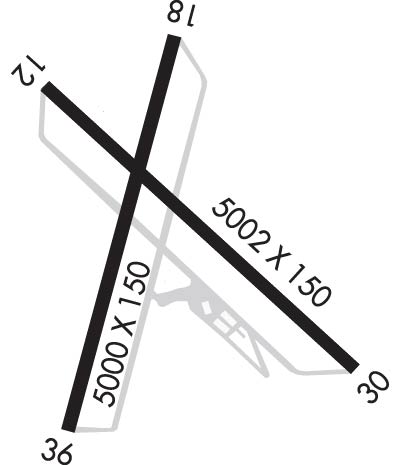
| Lat: N 4146.8 Long: W 12414.2 Elev: 61 Var: -14 Longest Runway: 5002 | ||
| AWOS: 119.92 CTAF: 122.8 | ||
| ||||||||||||||||||||||||||||||||||||||||||||
| ||||||||||||||||||||||||||||||||||||||||||||
| ||||||||||||||||||||||||||||||||||||||||||||
| Rwy | Rwy | |||||||
| 5002x150 | 5002' | 108.70 - 119° | 5002x150 | 5002' | ||||
| 5000x150 | 4852' | 5000x150 | 5000' | |||||
| Runway ID | Single Wheel | Double Wheel | Double Tandem Wheel | Dual Double Wheel |
| 12/30 | 30,000 | 43,000 | N/A | N/A |
| 18/36 | 30,000 | 43,000 | N/A | N/A |
| These numbers are Advisory and are not limits. The Airport Manager should have more accurate Weight Limits | ||||
 Airport Diagram might not be current. | |
| Facility Name: | JACK MC NAMARA FLD |
| City Name: | CRESCENT CITY |
| County: | DEL NORTE |
| State abbrev: | CA |
| State Name: | CALIFORNIA |
| Ownership: | PUBLICLY OWNED |
| Use: | OPEN TO THE PUBLIC |
| Owner's Name: | BORDER COAST REGIONAL ARPT AUTH |
| Address: | 1650 DALE RUPERT ROAD, SUITE 100 |
| CRESCENT CITY, CA 95531 | |
| Owner's Phone: | 707-464-7288 |
| Manager's Name: | RANDY HOOPER |
| Address: | 1650 DALE RUPERT RD, SUITE 100 |
| CRESCENT CITY, CA 95531 | |
| Phone: | 707-464-7288 |
| FAA Region: | WESTERN-PACIFIC |
| FAA Field Office: | SFO |
| Date | Sunrise | Sunset |
|---|---|---|
| 09/24/21 Friday | 7:06 | 19:11 |
| 09/25/21 Saturday | 7:07 | 19:09 |
| 09/26/21 Sunday | 7:08 | 19:07 |
| 09/27/21 Monday | 7:09 | 19:06 |
| 09/28/21 Tuesday | 7:10 | 19:04 |
| 09/29/21 Wednesday | 7:12 | 19:02 |
| 09/30/21 Thursday | 7:13 | 19:01 |
| 10/01/21 Friday | 7:14 | 18:59 |
| 10/02/21 Saturday | 7:15 | 18:57 |
| 10/03/21 Sunday | 7:16 | 18:55 |
| 10/04/21 Monday | 7:17 | 18:54 |
| 10/05/21 Tuesday | 7:18 | 18:52 |
| 10/06/21 Wednesday | 7:19 | 18:50 |
| 10/07/21 Thursday | 7:20 | 18:49 |
| Airport Attendance Schedule | 7 Days A Week 0800-1800; OTR HRS FBO REQUIRES CALL OUT FEE. |
| Airport Status | OPERATIONAL (This Status can change at any time - please check NOTAMS) |
| Airport Lighting Schedule | ACTVT MALSR RWY 12; REIL RWY 18, 36, & 30; HIRL RWY 12/30; MIRL RWY 18/36 - CTAF. |
| Airport Storage Available | Tie Downs |
| Extra Services Available | Air Freight, Air Ambulance, Charter, Flight Instruction, Aircraft Rental, Aircraft Sales, Annual Surveying |
| Wind Indicator | YES - (lighted) |
| Control Tower | NO |
| CTAF Frequency | 122.800 |
| Unicom Frequency | 122.800 |
| Rotating Beacon Color | CLEAR-GREEN (Light Land Airport) |
| Segmented Circle | YES |
| Landing Fee | NO |
| Airport Inspected | FEDERAL - performed by FAA AIRPORTS FIELD PERSONNEL |
| Inspection Date | 07/18/2019 |
| Type of Fuel Available | Grade 100LL, JET A (freeze point -40C) |
| Airframe Repair Service | MINOR |
| Power Plant Repair Service | MINOR |
| Latitude | N4146.8 |
| Longitude | W12414.2 (ESTIMATED) |
| Arpt Elevation | 60ft (SURVEYED) |
| Magnetic Variation | 14E |
| 3 miles NW | of CRESCENT CITY |
| Traffic Pattern Altitude | |
| Sectional Chart | KLAMATH FALLS |
| Operations (Reported) | Yearly | Avg. Daily |
|---|---|---|
| General Aviation Transient | 2800 | 8 |
| General Aviation Local | 6200 | 17 |
| Air Taxi | 3390 | 9 |
| Commerical | 0 | 0 |
| Commuter | 0 | 0 |
| Military | 175 | 0 |
| Aircraft based on Field | |
|---|---|
| General Aviation Singles | 11 |
| General Aviation Multi | 6 |
| Jet Aircraft | 0 |
| General Aviation Helicopters | 0 |
| Military Aircraft | 0 |
| Gliders | 0 |
| Ultralights | 0 |
| FSS on field | NO |
| FSS tie-in | OAKLAND |
| FSS Phone | 1-800-WX-BRIEF |
| Who issues Notams | CEC |
| Notam D service at airport | YES |
| ARTCC Name | SEATTLE |
| Airport Certification | PPR FOR UNSKED ACR OPNS WITH MORE THAN 30 PSGR SEATS CALL AMGR 707-464-7288 OR 707-465-3804. |
| Aircraft Rescue & Firefighting Index | AIRPORT HAS A CERTIFICATE UNDER CFR PART 139 |
| Airport of Entry | No |
| Custom Landing Rights | No |
| Joint Civil/Military | No |
| Military Landing rights | YES |
| NATIONAL PLAN OF INTEGRATED AIRPORT SYSTEMS (NPIAS) |
| GRANT AGREEMENTS UNDER FAAP/ADAP/AIP |
| SURPLUS PROPERTY AGREEMENT UNDER REGULATION 16-WAA |
| ASSURANCES PURSUANT TO TITLE VI, CIVIL RIGHTS ACT OF 1964 |
| A 150 FT LGTD TWR 3300 FT W CEC VOR. |
| BIRDS AND DEER ON & INVOF ARPT. |
| RIDGE LNS OF SHIFTING SAND DUNES 30-50 FT AGL AND 1000 FT OFF APCH END RWY 18. |
| TSNT PRKG RAMP ESTD WGT LIMIT 20000 LBS, FBO RAMP ESTD WGT LIMIT 60000 LBS. |
| FOR CD IF UNA TO CTC ON FSS FREQ, CTC SEATTLE ARTCC AT 253-351-3694. |
Airport Communications & Frequencies:
| |||||||||
| Runway: 12 | Runway: 30 | ||
| Mag heading: | 119° | Mag heading: | 299° |
| Rwy Slope: | -.08% Down | Rwy Slope: | .08% Up |
| Approach: | ILS | Approach: | |
| Pattern: | Left Traffic | Pattern: | Left Traffic |
| Markings: | PRECISION INSTRUMENT | Markings: | PRECISION INSTRUMENT |
| Marking Condition: | FAIR | Marking Condition: | FAIR |
| Arresting Dev: | Arresting Dev: | ||
| Lat & Long: | N4147.1 W12414.5 | Lat. & Long.: | N4146.5 W12413.7 |
| Elev: | 56.9 ft. MSL | Elev: | 53.0 ft. MSL |
| TCH: | TCH: | 60 ft. AGL | |
| Visual Glide Path: | Visual Glide Path: | 3.50 degrees | |
| Displaced Threshold: | No | Displaced Threshold: | No |
| Touchdown Zone: | YES | Touchdown Zone: | YES |
| Touchdown Elev.: | 60.1 feet | Touchdown Elev.: | 59.1 feet |
| Visual Glide Slope: | Visual Glide Slope: | 4-BOX VASI ON LEFT SIDE OF RUNWAY | |
| RVR Equipment: | RVR Equipment: | ||
| RVV Equipment: | NO | RVV Equipment: | NO |
| Approach Lights: | MALSR - 1,400 foot medium intensity approach lighting system with runway alignment indicator lights | Approach Lights: | |
| REIL: | NO | REIL: | YES |
| Centerline Lights: | NO | Centerline Lights: | NO |
| Touchdown lights: | NO | Touchdown lights: | NO |
| Runway Category: | Precision Instrument Runway | Runway Category: | Runway with a Visual Approach |
| Declared Distances: | Declared Distances: | ||
| Obstructions: | Obstructions: | TREES | |
| Marked: | Marked: | NOT Marked/Lighted | |
| Clearance slope: | 50:1 | Clearance slope: | 15:1 |
| Obstruction height: | Obstruction height: | 86 feet AGL | |
| Dist. from runway: | Dist. from runway: | 1520 feet | |
| Centerline offset: | Centerline offset: | 250 feet right of centerline | |
| Comments: | Comments: |
| Runway: 18 | Runway: 36 | ||
| Mag heading: | 179° | Mag heading: | 359° |
| Rwy Slope: | -.20% Down | Rwy Slope: | .20% Up |
| Approach: | Approach: | ||
| Pattern: | Left Traffic | Pattern: | Left Traffic |
| Markings: | NONPRECISION INSTRUMENT | Markings: | NONPRECISION INSTRUMENT |
| Marking Condition: | FAIR | Marking Condition: | FAIR |
| Arresting Dev: | Arresting Dev: | ||
| Lat & Long: | N4147.2 W12414.2 | Lat. & Long.: | N4146.4 W12414.4 |
| Elev: | 60.6 ft. MSL | Elev: | 50.6 ft. MSL |
| TCH: | TCH: | 48 ft. AGL | |
| Visual Glide Path: | Visual Glide Path: | 3.00 degrees | |
| Displaced Threshold: | 148 feet | Displaced Threshold: | No |
| Touchdown Zone: | YES | Touchdown Zone: | YES |
| Touchdown Elev.: | 60.7 feet | Touchdown Elev.: | 59.2 feet |
| Visual Glide Slope: | Visual Glide Slope: | 4-BOX VASI ON LEFT SIDE OF RUNWAY | |
| RVR Equipment: | RVR Equipment: | ||
| RVV Equipment: | NO | RVV Equipment: | NO |
| Approach Lights: | Approach Lights: | ||
| REIL: | YES | REIL: | YES |
| Centerline Lights: | NO | Centerline Lights: | NO |
| Touchdown lights: | NO | Touchdown lights: | NO |
| Runway Category: | Runway with a Visual Approach | Runway Category: | Runway with a Non-precision Approach having visibility minimums greater than 3/4 mile |
| Declared Distances: | Declared Distances: | ||
| Obstructions: | GND | Obstructions: | ROAD |
| Marked: | NOT Marked/Lighted | Marked: | NOT Marked/Lighted |
| Clearance slope: | 15:1 | Clearance slope: | 16:1 |
| Obstruction height: | 55 feet AGL | Obstruction height: | 9 feet AGL |
| Dist. from runway: | 1075 feet | Dist. from runway: | 350 feet |
| Centerline offset: | 250 right of centerline | Centerline offset: | |
| Comments: | Comments: |
Thanks for using FltPlan.com
all rights reserved © 1999-2021 by Flight Plan LLC
