
| CHILDRESS MUNI CHILDRESS TX |
| |
| Lat: N 3426.0 Long: W 10017.3 Elev: 1954 Var: -06 Longest Runway: 5949 | ||
| AWOS: 135.12 CTAF: 122.8 | ||
| ||||||||||||||||||||||||||||||||||||||||||||||||||||||||||||||||||||
| ||||||||||||||||||||||||||||||||||||||||||||||||||||||||||||||||||||
| ||||||||||||||||||||||||||||||||||||||||||||||||||||||||||||||||||||
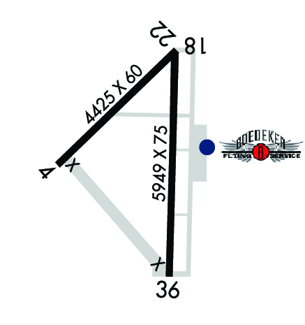
| Rwy | Rwy | |||||||
| 4425x60 | 4425' | 4425x60 | 4425' | |||||
| 5949x75 | 5949' | 5949x75 | 5949' | |||||
| Runway ID | Single Wheel | Double Wheel | Double Tandem Wheel | Dual Double Wheel |
| 04/22 | 21,000 | N/A | N/A | N/A |
| 18/36 | 21,000 | N/A | N/A | N/A |
| These numbers are Advisory and are not limits. The Airport Manager should have more accurate Weight Limits | ||||
 Airport Diagram might not be current. | |
| Facility Name: | CHILDRESS MUNI |
| City Name: | CHILDRESS |
| County: | CHILDRESS |
| State abbrev: | TX |
| State Name: | TEXAS |
| Ownership: | PUBLICLY OWNED |
| Use: | OPEN TO THE PUBLIC |
| Owner's Name: | CITY OF CHILDRESS; KEVIN HODGES, CITY MGR. |
| Address: | 315 COMMERCE STREET |
| CHILDRESS, TX 79201 | |
| Owner's Phone: | 940-937-3684 |
| Manager's Name: | TIFFANY TULLY |
| Address: | 15716 FM 164 |
| CHILDRESS, TX 79201 | |
| Phone: | 940-937-8309 |
| FAA Region: | SOUTHWEST |
| FAA Field Office: | TEX |
| Date | Sunrise | Sunset |
|---|---|---|
| 09/24/21 Friday | 7:30 | 19:35 |
| 09/25/21 Saturday | 7:31 | 19:34 |
| 09/26/21 Sunday | 7:32 | 19:33 |
| 09/27/21 Monday | 7:33 | 19:31 |
| 09/28/21 Tuesday | 7:33 | 19:30 |
| 09/29/21 Wednesday | 7:34 | 19:28 |
| 09/30/21 Thursday | 7:35 | 19:27 |
| 10/01/21 Friday | 7:36 | 19:26 |
| 10/02/21 Saturday | 7:36 | 19:24 |
| 10/03/21 Sunday | 7:37 | 19:23 |
| 10/04/21 Monday | 7:38 | 19:21 |
| 10/05/21 Tuesday | 7:39 | 19:20 |
| 10/06/21 Wednesday | 7:39 | 19:19 |
| 10/07/21 Thursday | 7:40 | 19:17 |
| Airport Attendance Schedule | MON-FRI 0900-1700 |
| Airport Status | OPERATIONAL (This Status can change at any time - please check NOTAMS) |
| Airport Lighting Schedule | MIRL RY 18/36 PRESET LOW INTST; TO INCR INTST ACTVT - CTAF. |
| Airport Storage Available | Tie Downs |
| Extra Services Available | Crop Dusting |
| Wind Indicator | YES - (lighted) |
| Control Tower | NO |
| CTAF Frequency | 122.800 |
| Unicom Frequency | 122.800 |
| Rotating Beacon Color | CLEAR-GREEN (Light Land Airport) |
| Segmented Circle | YES |
| Landing Fee | NO |
| Airport Inspected | STATE - performed by STATE AERONAUTICAL PERSONNEL |
| Inspection Date | 05/15/2018 |
| Type of Fuel Available | Grade 100LL, JET A (freeze point -40C); -1024 HR SELF SVC 100LL AND JET A. FULL SVC JET A AVBL DURNG OPS HRS; AFT HRS CALL 940-937-8309. |
| Airframe Repair Service | None |
| Power Plant Repair Service | None |
| Latitude | N3426.0 |
| Longitude | W10017.3 (ESTIMATED) |
| Arpt Elevation | 1953ft (SURVEYED) |
| Magnetic Variation | 06E |
| 4 miles W | of CHILDRESS |
| Traffic Pattern Altitude | |
| Sectional Chart | DALLAS-FT WORTH |
| Operations (Reported) | Yearly | Avg. Daily |
|---|---|---|
| General Aviation Transient | 1400 | 4 |
| General Aviation Local | 2800 | 8 |
| Air Taxi | 0 | 0 |
| Commerical | 0 | 0 |
| Commuter | 0 | 0 |
| Military | 40 | 0 |
| Aircraft based on Field | |
|---|---|
| General Aviation Singles | 13 |
| General Aviation Multi | 1 |
| Jet Aircraft | 0 |
| General Aviation Helicopters | 1 |
| Military Aircraft | 0 |
| Gliders | 0 |
| Ultralights | 2 |
| FSS on field | NO |
| FSS tie-in | FORT WORTH |
| FSS Phone | 1-800-WX-BRIEF |
| Who issues Notams | CDS |
| Notam D service at airport | YES |
| ARTCC Name | FORT WORTH |
| Airport Certification | |
| Aircraft Rescue & Firefighting Index | None |
| Airport of Entry | No |
| Custom Landing Rights | No |
| Joint Civil/Military | No |
| Military Landing rights | YES |
| GRANT AGREEMENTS UNDER FAAP/ADAP/AIP |
| SURPLUS PROPERTY AGREEMENT UNDER PUBLIC LAW 289 |
| ASSURANCES PURSUANT TO TITLE VI, CIVIL RIGHTS ACT OF 1964 |
| THIS AIRPORT HAS BEEN SURVEYED BY THE NATIONAL GEODETIC SURVEY. |
| SOME TWYS ROUGH DUE TO GRASS & WEED ENCROACHMENT. |
| AGRICULTURE OPNS NEAR ALL RWYS. |
| FOR CD IF UNA TO CTC ON FSS FREQ, CTC FORT WORTH ARTCC AT 817-858-7584. |
| RWY 04/2 2 CLSD INDEFLY. |
| RWY 04/2 2 RY NOT MAINTAINED; VEGETATION ON RY. |
| RWY 18/3 6 NSTD MIRL RY 36 THLD LGTS 60 FT SOUTH OF RY END. |
Airport Communications & Frequencies:
| |||||||||
| Runway: 04 | Runway: 22 | ||
| Mag heading: | 41° | Mag heading: | 221° |
| Rwy Slope: | .17% Up | Rwy Slope: | -.17% Down |
| Approach: | Approach: | ||
| Pattern: | Left Traffic | Pattern: | Left Traffic |
| Markings: | BASIC | Markings: | BASIC |
| Marking Condition: | POOR | Marking Condition: | POOR |
| Arresting Dev: | Arresting Dev: | ||
| Lat & Long: | N3425.9 W10017.8 | Lat. & Long.: | N3426.4 W10017.1 |
| Elev: | 1941.6 ft. MSL | Elev: | 1949.0 ft. MSL |
| TCH: | TCH: | ||
| Visual Glide Path: | Visual Glide Path: | ||
| Displaced Threshold: | No | Displaced Threshold: | No |
| Touchdown Zone: | YES | Touchdown Zone: | YES |
| Touchdown Elev.: | 1946.4 feet | Touchdown Elev.: | 1949.1 feet |
| Visual Glide Slope: | Visual Glide Slope: | ||
| RVR Equipment: | RVR Equipment: | ||
| RVV Equipment: | NO | RVV Equipment: | NO |
| Approach Lights: | Approach Lights: | ||
| REIL: | NO | REIL: | NO |
| Centerline Lights: | NO | Centerline Lights: | NO |
| Touchdown lights: | NO | Touchdown lights: | NO |
| Runway Category: | Runway with a Visual Approach | Runway Category: | Runway with a Visual Approach |
| Declared Distances: | Declared Distances: |
| Runway: 18 | Runway: 36 | ||
| Mag heading: | 176° | Mag heading: | 356° |
| Rwy Slope: | .08% Up | Rwy Slope: | -.08% Down |
| Approach: | Approach: | ||
| Pattern: | Left Traffic | Pattern: | Left Traffic |
| Markings: | NONPRECISION INSTRUMENT | Markings: | NONPRECISION INSTRUMENT |
| Marking Condition: | FAIR | Marking Condition: | FAIR |
| Arresting Dev: | Arresting Dev: | ||
| Lat & Long: | N3426.4 W10017.1 | Lat. & Long.: | N3425.4 W10017.2 |
| Elev: | 1948.8 ft. MSL | Elev: | 1953.8 ft. MSL |
| TCH: | 40 ft. AGL | TCH: | 40 ft. AGL |
| Visual Glide Path: | 3.00 degrees | Visual Glide Path: | 3.00 degrees |
| Displaced Threshold: | No | Displaced Threshold: | No |
| Touchdown Zone: | YES | Touchdown Zone: | YES |
| Touchdown Elev.: | 1951.3 feet | Touchdown Elev.: | 1953.8 feet |
| Visual Glide Slope: | 2-Light PAPI on LEFT side of Runway | Visual Glide Slope: | 2-Light PAPI on LEFT side of Runway |
| RVR Equipment: | RVR Equipment: | ||
| RVV Equipment: | NO | RVV Equipment: | NO |
| Approach Lights: | Approach Lights: | ||
| REIL: | NO | REIL: | NO |
| Centerline Lights: | NO | Centerline Lights: | NO |
| Touchdown lights: | NO | Touchdown lights: | NO |
| Runway Category: | Runway with a Visual Approach | Runway Category: | D |
| Declared Distances: | Declared Distances: | ||
| Obstructions: | POLE | Obstructions: | |
| Marked: | NOT Marked/Lighted | Marked: | |
| Clearance slope: | 35:1 | Clearance slope: | 50:1 |
| Obstruction height: | 25 feet AGL | Obstruction height: | |
| Dist. from runway: | 1090 feet | Dist. from runway: | |
| Centerline offset: | 396 left of centerline | Centerline offset: | |
| Comments: | +10 FT ROAD 25 FT FM RY END 0B. | Comments: | +10 FT ROAD 35 FT AND 78 FT FM RY END 0B. |
Thanks for using FltPlan.com
all rights reserved © 1999-2021 by Flight Plan LLC


