| CHADRON MUNI CHADRON NE |
| |
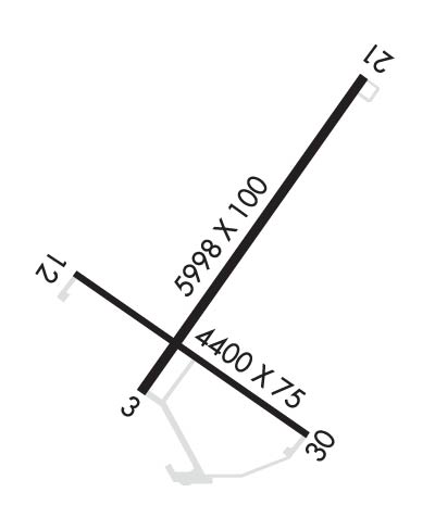
| Lat: N 4250.3 Long: W 10305.7 Elev: 3298 Var: -07 Longest Runway: 5998 | ||
| AWOS: 118.05 CTAF: 122.8 | ||
| |||||||||||||||||||||||
| |||||||||||||||||||||||
| |||||||||||||||||||||||
| Rwy | Rwy | |||||||
| 5998x100 | 5709' | 110.90 - 028° | 5998x100 | 5500' | ||||
| 4400x75 | 4400' | 4400x75 | 4400' | |||||
| Runway ID | Single Wheel | Double Wheel | Double Tandem Wheel | Dual Double Wheel |
| 03/21 | 30,000 | 55,000 | 90,000 | N/A |
| 12/30 | 21,000 | 30,000 | N/A | N/A |
| These numbers are Advisory and are not limits. The Airport Manager should have more accurate Weight Limits | ||||
 Airport Diagram might not be current. | |
| Facility Name: | CHADRON MUNI |
| City Name: | CHADRON |
| County: | DAWES |
| State abbrev: | NE |
| State Name: | NEBRASKA |
| Ownership: | PUBLICLY OWNED |
| Use: | OPEN TO THE PUBLIC |
| Owner's Name: | CITY OF CHADRON |
| Address: | P.O. BOX 390 |
| CHADRON, NE 69337-0390 | |
| Owner's Phone: | 308-432-0505 |
| Manager's Name: | MR. TOM MENKE; ROGER STEVENS ON SITE AIRPORT OPERATIONS SUPERVISOR. ARPT OFFICE 308-615-9007 |
| Address: | P.O. BOX 390 |
| CHADRON, NE 69337-0390 | |
| Phone: | 308-432-0505 |
| FAA Region: | CENTRAL |
| FAA Field Office: | NONE |
| Date | Sunrise | Sunset |
|---|---|---|
| 06/08/26 Monday | 5:14 | 20:29 |
| 06/09/26 Tuesday | 5:14 | 20:30 |
| 06/10/26 Wednesday | 5:14 | 20:30 |
| 06/11/26 Thursday | 5:13 | 20:31 |
| 06/12/26 Friday | 5:13 | 20:31 |
| 06/13/26 Saturday | 5:13 | 20:32 |
| 06/14/26 Sunday | 5:13 | 20:32 |
| 06/15/26 Monday | 5:13 | 20:33 |
| 06/16/26 Tuesday | 5:13 | 20:33 |
| 06/17/26 Wednesday | 5:13 | 20:33 |
| 06/18/26 Thursday | 5:13 | 20:34 |
| 06/19/26 Friday | 5:13 | 20:34 |
| 06/20/26 Saturday | 5:14 | 20:34 |
| 06/21/26 Sunday | 5:14 | 20:34 |
| Airport Attendance Schedule | 7 Days A Week 0800-1600 |
| Airport Status | OPERATIONAL (This Status can change at any time - please check NOTAMS) |
| Airport Lighting Schedule | ACTVT HIRL RY 03/21 & MIRL RY 12/30; REIL RY 21 & RY 30 ; PAPI RYS 12/30; VASI RYS 03/21; MALSR RY 03 - CTAF. |
| Airport Storage Available | Tie Downs, Hanger |
| Extra Services Available | Charter |
| Wind Indicator | YES - (lighted) |
| Control Tower | NO |
| CTAF Frequency | 122.800 |
| Unicom Frequency | 122.800 |
| Rotating Beacon Color | WG |
| Segmented Circle | YES |
| Landing Fee | NO |
| Airport Inspected | STATE - performed by STATE AERONAUTICAL PERSONNEL |
| Inspection Date | 08/10/2023 |
| Type of Fuel Available | Grade 100LL, JET A (freeze point -40C) |
| Airframe Repair Service | MAJOR |
| Power Plant Repair Service | MAJOR |
| Latitude | N4250.3 |
| Longitude | W10305.7 (ESTIMATED) |
| Arpt Elevation | 3297ft (SURVEYED) |
| Magnetic Variation | 07E |
| 4 miles W | of CHADRON |
| Traffic Pattern Altitude | |
| Sectional Chart | CHEYENNE |
| Operations (Reported) | Yearly | Avg. Daily |
|---|---|---|
| General Aviation Transient | 0 | 0 |
| General Aviation Local | 0 | 0 |
| Air Taxi | 0 | 0 |
| Commerical | 0 | 0 |
| Commuter | 0 | 0 |
| Military | 0 | 0 |
| Aircraft based on Field | |
|---|---|
| General Aviation Singles | 0 |
| General Aviation Multi | 0 |
| Jet Aircraft | 0 |
| General Aviation Helicopters | 0 |
| Military Aircraft | 0 |
| Gliders | 0 |
| Ultralights | 0 |
| FSS on field | NO |
| FSS tie-in | COLUMBUS |
| FSS Phone | 1-800-WX-BRIEF |
| Who issues Notams | CDR |
| Notam D service at airport | YES |
| ARTCC Name | DENVER |
| Airport Certification | |
| Aircraft Rescue & Firefighting Index | None |
| Airport of Entry | No |
| Custom Landing Rights | No |
| Joint Civil/Military | No |
| Military Landing rights | YES |
| NATIONAL PLAN OF INTEGRATED AIRPORT SYSTEMS (NPIAS) |
| GRANT AGREEMENTS UNDER FAAP/ADAP/AIP |
| ADVANCE PLANNING AGREEMENT UNDER FAAP |
| ASSURANCES PURSUANT TO TITLE VI, CIVIL RIGHTS ACT OF 1964 |
| FOR CD IF UNA TO CTC ON FSS FREQ, CTC DENVER ARTCC AT 303-651-4257. |
Airport Communications & Frequencies:
| |||||||||
| Runway: 03 | Runway: 21 | ||
| Mag heading: | 28° | Mag heading: | 208° |
| Rwy Slope: | -.49% Down | Rwy Slope: | .49% Up |
| Approach: | ILS | Approach: | |
| Pattern: | Left Traffic | Pattern: | Left Traffic |
| Markings: | PRECISION INSTRUMENT | Markings: | NONPRECISION INSTRUMENT |
| Marking Condition: | GOOD | Marking Condition: | GOOD |
| Arresting Dev: | Arresting Dev: | ||
| Lat & Long: | N4250.0 W10306.0 | Lat. & Long.: | N4250.8 W10305.2 |
| Elev: | 3297.8 ft. MSL | Elev: | 3268.7 ft. MSL |
| TCH: | 61 ft. AGL | TCH: | 41 ft. AGL |
| Visual Glide Path: | 3.00 degrees | Visual Glide Path: | 3.00 degrees |
| Displaced Threshold: | 289 feet | Displaced Threshold: | 498 feet |
| Touchdown Zone: | YES | Touchdown Zone: | YES |
| Touchdown Elev.: | 3294.4 feet | Touchdown Elev.: | 3285.7 feet |
| Visual Glide Slope: | 4-BOX VASI ON LEFT SIDE OF RUNWAY | Visual Glide Slope: | 4-BOX VASI ON LEFT SIDE OF RUNWAY |
| RVR Equipment: | RVR Equipment: | ||
| RVV Equipment: | NO | RVV Equipment: | NO |
| Approach Lights: | MALSR - 1,400 foot medium intensity approach lighting system with runway alignment indicator lights | Approach Lights: | |
| REIL: | NO | REIL: | YES |
| Centerline Lights: | NO | Centerline Lights: | NO |
| Touchdown lights: | NO | Touchdown lights: | NO |
| Runway Category: | Precision Instrument Runway | Runway Category: | D |
| Declared Distances: | TORA:5998' TODA:5998' ASDA:5500' LDA:5211' | Declared Distances: | TORA:5998' TODA:5998' ASDA:5500' LDA:5500' |
| Obstructions: | Obstructions: | BRUSH | |
| Marked: | Marked: | NOT Marked/Lighted | |
| Clearance slope: | 50:1; APCH RATIO 45:1 FM DSPLCD THR. | Clearance slope: | 9:1 |
| Obstruction height: | Obstruction height: | 14 feet AGL | |
| Dist. from runway: | Dist. from runway: | 331 feet | |
| Centerline offset: | Centerline offset: | 426 feet left of centerline | |
| Comments: | Comments: |
| Runway: 12 | Runway: 30 | ||
| Mag heading: | 118° | Mag heading: | 298° |
| Rwy Slope: | -.23% Down | Rwy Slope: | .23% Up |
| Approach: | Approach: | ||
| Pattern: | Left Traffic | Pattern: | Left Traffic |
| Markings: | NONPRECISION INSTRUMENT | Markings: | NONPRECISION INSTRUMENT |
| Marking Condition: | GOOD | Marking Condition: | GOOD |
| Arresting Dev: | Arresting Dev: | ||
| Lat & Long: | N4250.3 W10306.3 | Lat. & Long.: | N4249.9 W10305.4 |
| Elev: | 3293.7 ft. MSL | Elev: | 3283.7 ft. MSL |
| TCH: | 29 ft. AGL | TCH: | 41 ft. AGL |
| Visual Glide Path: | 3.00 degrees | Visual Glide Path: | 3.00 degrees |
| Displaced Threshold: | No | Displaced Threshold: | No |
| Touchdown Zone: | YES | Touchdown Zone: | YES |
| Touchdown Elev.: | 3293.7 feet | Touchdown Elev.: | 3289.7 feet |
| Visual Glide Slope: | 4-Light PAPI on LEFT side of Runway | Visual Glide Slope: | 4-Light PAPI on LEFT side of Runway |
| RVR Equipment: | RVR Equipment: | ||
| RVV Equipment: | NO | RVV Equipment: | NO |
| Approach Lights: | Approach Lights: | ||
| REIL: | NO | REIL: | YES |
| Centerline Lights: | NO | Centerline Lights: | NO |
| Touchdown lights: | NO | Touchdown lights: | NO |
| Runway Category: | Runway with a Visual Approach | Runway Category: | Runway with a Visual Approach |
| Declared Distances: | TORA:4400' TODA:4400' ASDA:4400' LDA:4400' | Declared Distances: | TORA:4400' TODA:4400' ASDA:4400' LDA:4400' |
| Obstructions: | TREES | Obstructions: | ROAD |
| Marked: | NOT Marked/Lighted | Marked: | NOT Marked/Lighted |
| Clearance slope: | 49:1 | Clearance slope: | 34:1 |
| Obstruction height: | 15 feet AGL | Obstruction height: | 35 feet AGL |
| Dist. from runway: | 936 feet | Dist. from runway: | 1400 feet |
| Centerline offset: | 169 right of centerline | Centerline offset: | 220 feet left of centerline |
| Comments: | Comments: |
Thanks for using FltPlan.com
all rights reserved © 1999-2026 by Flight Plan LLC