
| HARRELL FIELD CAMDEN AR |
| |
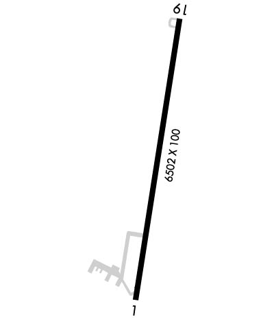
| Lat: N 3337.4 Long: W 09245.8 Elev: 130 Var: -02 Longest Runway: 6502 | ||
| AWOS: 125.2 CTAF: 122.7 | ||
| ||||||
| ||||||
|
| Rwy | Rwy | |||||||
| 6502x100 | 6502' | 6502x100 | 6502' | |||||
| Runway ID | Single Wheel | Double Wheel | Double Tandem Wheel | Dual Double Wheel |
| 01/19 | 86,000 | 112,000 | 180,000 | N/A |
| These numbers are Advisory and are not limits. The Airport Manager should have more accurate Weight Limits | ||||
 Airport Diagram might not be current. | |
| Facility Name: | HARRELL FLD |
| City Name: | CAMDEN |
| County: | OUACHITA |
| State abbrev: | AR |
| State Name: | ARKANSAS |
| Ownership: | PUBLICLY OWNED |
| Use: | OPEN TO THE PUBLIC |
| Owner's Name: | CITY OF CAMDEN |
| Address: | PO BOX 278 |
| CAMDEN, AR 71711 | |
| Owner's Phone: | 870-836-6436 |
| Manager's Name: | KYLE GATLING |
| Address: | 255 AIRPORT RD |
| CAMDEN, AR 71701 | |
| Phone: | 870-818-3408 |
| FAA Region: | SOUTHWEST |
| FAA Field Office: | AOK |

| Date | Sunrise | Sunset |
|---|---|---|
| 09/24/21 Friday | 7:00 | 19:05 |
| 09/25/21 Saturday | 7:01 | 19:04 |
| 09/26/21 Sunday | 7:02 | 19:03 |
| 09/27/21 Monday | 7:02 | 19:01 |
| 09/28/21 Tuesday | 7:03 | 19:00 |
| 09/29/21 Wednesday | 7:04 | 18:58 |
| 09/30/21 Thursday | 7:05 | 18:57 |
| 10/01/21 Friday | 7:05 | 18:56 |
| 10/02/21 Saturday | 7:06 | 18:54 |
| 10/03/21 Sunday | 7:07 | 18:53 |
| 10/04/21 Monday | 7:07 | 18:52 |
| 10/05/21 Tuesday | 7:08 | 18:50 |
| 10/06/21 Wednesday | 7:09 | 18:49 |
| 10/07/21 Thursday | 7:10 | 18:48 |
| Airport Attendance Schedule | 7 Days A Week UNATTENDED; FOR SVC AFT HRS CALL 870-818-3408. |
| Airport Status | OPERATIONAL (This Status can change at any time - please check NOTAMS) |
| Airport Lighting Schedule | ACTVT MIRL RY 18/36, PAPI RYS 18 & 36 AND REIL RYS 18 & 36 - CTAF. |
| Airport Storage Available | Tie Downs, Hanger |
| Extra Services Available | NONE |
| Wind Indicator | YES - (lighted) |
| Control Tower | NO |
| CTAF Frequency | 122.700 |
| Unicom Frequency | 122.700 |
| Rotating Beacon Color | CLEAR-GREEN (Light Land Airport) |
| Segmented Circle | YES |
| Landing Fee | NO |
| Airport Inspected | STATE - performed by STATE AERONAUTICAL PERSONNEL |
| Inspection Date | 03/22/2019 |
| Type of Fuel Available | Grade 100LL, JET A (freeze point -40C); -10FUEL AVBL SELF SERVE 24 HRS WITH CREDIT CARD (100LL & JET A). |
| Airframe Repair Service | NONE |
| Power Plant Repair Service | NONE |
| Latitude | N3337.4 |
| Longitude | W09245.8 (ESTIMATED) |
| Arpt Elevation | 129ft (SURVEYED) |
| Magnetic Variation | 02E |
| 5 miles NE | of CAMDEN |
| Traffic Pattern Altitude | |
| Sectional Chart | MEMPHIS |
| Operations (Reported) | Yearly | Avg. Daily |
|---|---|---|
| General Aviation Transient | 8850 | 24 |
| General Aviation Local | 4750 | 13 |
| Air Taxi | 0 | 0 |
| Commerical | 0 | 0 |
| Commuter | 0 | 0 |
| Military | 400 | 1 |
| Aircraft based on Field | |
|---|---|
| General Aviation Singles | 7 |
| General Aviation Multi | 5 |
| Jet Aircraft | 1 |
| General Aviation Helicopters | 0 |
| Military Aircraft | 0 |
| Gliders | 0 |
| Ultralights | 0 |
| FSS on field | NO |
| FSS tie-in | JONESBORO |
| FSS Phone | 1-800-WX-BRIEF |
| Who issues Notams | JBR |
| Notam D service at airport | YES |
| ARTCC Name | FORT WORTH |
| Airport Certification | |
| Aircraft Rescue & Firefighting Index | None |
| Airport of Entry | No |
| Custom Landing Rights | No |
| Joint Civil/Military | No |
| Military Landing rights | YES |
| NATIONAL PLAN OF INTEGRATED AIRPORT SYSTEMS (NPIAS) |
| GRANT AGREEMENTS UNDER FAAP/ADAP/AIP |
| SURPLUS PROPERTY AGREEMENT UNDER PUBLIC LAW 289 |
| CONVEYANCE UNDER SCETION 16, FEDERAL AIRPORT ACT OF 1946 OR SECTION 23, AIRPORT AND AIRWAY DEVELOPMENT ACT OF 1970 |
| OBLIGATIONS ASSUMED BY TRANSFER |
| ASSURANCES PURSUANT TO TITLE VI, CIVIL RIGHTS ACT OF 1964 |
| THIS AIRPORT HAS BEEN SURVEYED BY THE NATIONAL GEODETIC SURVEY. |
| DEER ON & INVOF ARPT. |
| ULTRALIGHT ACTIVITY ON & INVOF ARPT. |
| FOR CD CTC FORT WORTH ARTCC AT 817-858-7584. |
Airport Communications & Frequencies:
| |||||||||
| Runway: 01 | Runway: 19 | ||
| Mag heading: | 7° | Mag heading: | 187° |
| Rwy Slope: | .10% Up | Rwy Slope: | -.10% Down |
| Approach: | Approach: | ||
| Pattern: | Left Traffic | Pattern: | Left Traffic |
| Markings: | NONPRECISION INSTRUMENT | Markings: | NONPRECISION INSTRUMENT |
| Marking Condition: | GOOD | Marking Condition: | GOOD |
| Arresting Dev: | Arresting Dev: | ||
| Lat & Long: | N3336.8 W09245.9 | Lat. & Long.: | N3337.9 W09245.7 |
| Elev: | 122.9 ft. MSL | Elev: | 129.6 ft. MSL |
| TCH: | 45 ft. AGL | TCH: | 43 ft. AGL |
| Visual Glide Path: | 3.00 degrees | Visual Glide Path: | 3.00 degrees |
| Displaced Threshold: | No | Displaced Threshold: | No |
| Touchdown Zone: | YES | Touchdown Zone: | YES |
| Touchdown Elev.: | 124.4 feet | Touchdown Elev.: | 129.6 feet |
| Visual Glide Slope: | 2-Light PAPI on LEFT side of Runway | Visual Glide Slope: | 2-Light PAPI on LEFT side of Runway |
| RVR Equipment: | RVR Equipment: | ||
| RVV Equipment: | NO | RVV Equipment: | NO |
| Approach Lights: | Approach Lights: | ||
| REIL: | YES | REIL: | YES |
| Centerline Lights: | NO | Centerline Lights: | NO |
| Touchdown lights: | NO | Touchdown lights: | NO |
| Runway Category: | Runway with a Non-precision Approach having visibility minimums greater than 3/4 mile | Runway Category: | Runway with a Non-precision Approach having visibility minimums greater than 3/4 mile |
| Declared Distances: | Declared Distances: | ||
| Obstructions: | TREES | Obstructions: | TREES |
| Marked: | NOT Marked/Lighted | Marked: | NOT Marked/Lighted |
| Clearance slope: | 18:1 | Clearance slope: | 19:1 |
| Obstruction height: | 45 feet AGL | Obstruction height: | 55 feet AGL |
| Dist. from runway: | 1050 feet | Dist. from runway: | 1250 feet |
| Centerline offset: | 360 right of centerline | Centerline offset: | 175 feet right of centerline |
| Comments: | Comments: |
Thanks for using FltPlan.com
all rights reserved © 1999-2021 by Flight Plan LLC