
| NORTHEAST IOWA RGNL CHARLES CITY IA |
| |
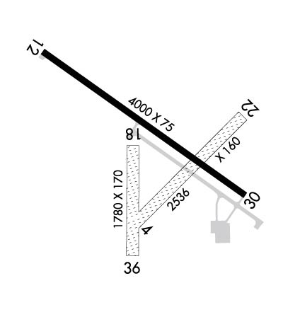
| Lat: N 4304.4 Long: W 09236.6 Elev: 1125 Var: +00 Longest Runway: 4000 | ||
| AWOS: 125.52 CTAF: 122.8 | ||
| ||||||||||||||||||||||||||||||||||||||||||||
| ||||||||||||||||||||||||||||||||||||||||||||
| ||||||||||||||||||||||||||||||||||||||||||||
| Rwy | Rwy | |||||||
| 2536x160 | 2536' | 2536x160 | 2536' | |||||
| 4000x75 | 4000' | 108.30 - 125° | 4000x75 | 4000' | ||||
| Runway ID | Single Wheel | Double Wheel | Double Tandem Wheel | Dual Double Wheel |
| 04/22 | N/A | N/A | N/A | N/A |
| 12/30 | 30,000 | N/A | N/A | N/A |
| These numbers are Advisory and are not limits. The Airport Manager should have more accurate Weight Limits | ||||
 Airport Diagram might not be current. | |
| Facility Name: | NORTHEAST IOWA RGNL |
| City Name: | CHARLES CITY |
| County: | FLOYD |
| State abbrev: | IA |
| State Name: | IOWA |
| Ownership: | PUBLICLY OWNED |
| Use: | OPEN TO THE PUBLIC |
| Owner's Name: | NORTH CEDAR AVIATION AUTHORITY; JEFF SISSON, CHAIRMAN |
| Address: | 3131 HWY 18 E |
| CHARLES CITY, IA 50616 | |
| Owner's Phone: | 641-228-3553 |
| Manager's Name: | WILLIAM R KYLE |
| Address: | 3129 HWY 18 |
| CHARLES CITY, IA 50616 | |
| Phone: | 641-228-3553 |
| FAA Region: | CENTRAL |
| FAA Field Office: | NONE |
| Date | Sunrise | Sunset |
|---|---|---|
| 06/12/26 Friday | 5:31 | 20:50 |
| 06/13/26 Saturday | 5:30 | 20:51 |
| 06/14/26 Sunday | 5:30 | 20:51 |
| 06/15/26 Monday | 5:30 | 20:52 |
| 06/16/26 Tuesday | 5:30 | 20:52 |
| 06/17/26 Wednesday | 5:30 | 20:52 |
| 06/18/26 Thursday | 5:31 | 20:53 |
| 06/19/26 Friday | 5:31 | 20:53 |
| 06/20/26 Saturday | 5:31 | 20:53 |
| 06/21/26 Sunday | 5:31 | 20:53 |
| 06/22/26 Monday | 5:31 | 20:54 |
| 06/23/26 Tuesday | 5:31 | 20:54 |
| 06/24/26 Wednesday | 5:32 | 20:54 |
| 06/25/26 Thursday | 5:32 | 20:54 |
| Airport Attendance Schedule | SUN 0800-1600, MON-SAT 0700-1700; FOR SVC AFT DUSK CALL (641) 330-4599/330-8448. |
| Airport Status | OPERATIONAL (This Status can change at any time - please check NOTAMS) |
| Airport Lighting Schedule | DUSK-DAWN. ACTVT REIL RWYS 12 & 30, PAPI RWY 12 & 30, MIRL RWY 12/30 - CTAF. |
| Airport Storage Available | Tie Downs, Hanger |
| Extra Services Available | Charter, Flight Instruction, Aircraft Rental, Aircraft Sales |
| Wind Indicator | YES - (lighted) |
| Control Tower | NO |
| CTAF Frequency | 122.800 |
| Unicom Frequency | 122.800 |
| Rotating Beacon Color | WG |
| Segmented Circle | NO |
| Landing Fee | NO |
| Airport Inspected | STATE - performed by STATE AERONAUTICAL PERSONNEL |
| Inspection Date | 03/30/2026 |
| Type of Fuel Available | Grade 100LL, JET A (freeze point -40C) |
| Airframe Repair Service | MAJOR |
| Power Plant Repair Service | MAJOR |
| Latitude | N4304.4 |
| Longitude | W09236.6 (ESTIMATED) |
| Arpt Elevation | 1125ft (SURVEYED) |
| Magnetic Variation | 00W |
| 3 miles E | of CHARLES CITY |
| Traffic Pattern Altitude | |
| Sectional Chart | CHICAGO |
| Operations (Reported) | Yearly | Avg. Daily |
|---|---|---|
| General Aviation Transient | 0 | 0 |
| General Aviation Local | 0 | 0 |
| Air Taxi | 0 | 0 |
| Commerical | 0 | 0 |
| Commuter | 0 | 0 |
| Military | 0 | 0 |
| Aircraft based on Field | |
|---|---|
| General Aviation Singles | 0 |
| General Aviation Multi | 0 |
| Jet Aircraft | 0 |
| General Aviation Helicopters | 0 |
| Military Aircraft | 0 |
| Gliders | 0 |
| Ultralights | 0 |
| FSS on field | NO |
| FSS tie-in | FORT DODGE |
| FSS Phone | 1-800-WX-BRIEF |
| Who issues Notams | CCY |
| Notam D service at airport | YES |
| ARTCC Name | MINNEAPOLIS |
| Airport Certification | |
| Aircraft Rescue & Firefighting Index | None |
| Airport of Entry | No |
| Custom Landing Rights | No |
| Joint Civil/Military | No |
| Military Landing rights | YES |
| NATIONAL PLAN OF INTEGRATED AIRPORT SYSTEMS (NPIAS) |
| GRANT AGREEMENTS UNDER FAAP/ADAP/AIP |
| ASSURANCES PURSUANT TO TITLE VI, CIVIL RIGHTS ACT OF 1964 |
| SAWRS AVBL ON ARPT. |
| FOR CD CTC DES MOINES APCH AT 515-974-8016. WHEN DES MOINES APP CLSD, FOR CD CTC MINNEAPOLIS ARTCC AT 651-463-5588. |
Airport Communications & Frequencies:
| |||||||||||||||||
| Runway: 04 | Runway: 22 | ||
| Mag heading: | 45° | Mag heading: | 225° |
| Rwy Slope: | .06% Up | Rwy Slope: | -.06% Down |
| Approach: | Approach: | ||
| Pattern: | Left Traffic | Pattern: | Left Traffic |
| Markings: | Markings: | ||
| Marking Condition: | THLDS & EDGES MKD WITH YELLOW CONES. | Marking Condition: | THLDS & EDGES MKD WITH YELLOW CONES. |
| Arresting Dev: | Arresting Dev: | ||
| Lat & Long: | N4304.2 W09236.7 | Lat. & Long.: | N4304.5 W09236.3 |
| Elev: | 1121.7 ft. MSL | Elev: | 1123.3 ft. MSL |
| TCH: | TCH: | ||
| Visual Glide Path: | Visual Glide Path: | ||
| Displaced Threshold: | No | Displaced Threshold: | No |
| Touchdown Zone: | YES | Touchdown Zone: | YES |
| Touchdown Elev.: | 1125.0 feet | Touchdown Elev.: | 1125.0 feet |
| Visual Glide Slope: | Visual Glide Slope: | ||
| RVR Equipment: | RVR Equipment: | ||
| RVV Equipment: | NO | RVV Equipment: | NO |
| Approach Lights: | Approach Lights: | ||
| REIL: | NO | REIL: | NO |
| Centerline Lights: | NO | Centerline Lights: | NO |
| Touchdown lights: | NO | Touchdown lights: | NO |
| Runway Category: | Runway with a Visual Approach | Runway Category: | Runway with a Visual Approach |
| Declared Distances: | Declared Distances: | ||
| Obstructions: | PLINE | Obstructions: | FENCE |
| Marked: | NOT Marked/Lighted | Marked: | NOT Marked/Lighted |
| Clearance slope: | 40:1 | Clearance slope: | 20:1 |
| Obstruction height: | 25 feet AGL | Obstruction height: | 4 feet AGL |
| Dist. from runway: | 1000 feet | Dist. from runway: | 80 feet |
| Centerline offset: | Centerline offset: | 80 feet right of centerline | |
| Comments: | Comments: |
| Runway: 12 | Runway: 30 | ||
| Mag heading: | 125° | Mag heading: | 305° |
| Rwy Slope: | .00% Down | Rwy Slope: | .00% Up |
| Approach: | LOCALIZER | Approach: | |
| Pattern: | Left Traffic | Pattern: | Left Traffic |
| Markings: | NONPRECISION INSTRUMENT | Markings: | NONPRECISION INSTRUMENT |
| Marking Condition: | FAIR | Marking Condition: | FAIR |
| Arresting Dev: | Arresting Dev: | ||
| Lat & Long: | N4304.6 W09237.1 | Lat. & Long.: | N4304.2 W09236.3 |
| Elev: | 1116.6 ft. MSL | Elev: | 1116.5 ft. MSL |
| TCH: | 40 ft. AGL | TCH: | 40 ft. AGL |
| Visual Glide Path: | 3.00 degrees | Visual Glide Path: | 3.00 degrees |
| Displaced Threshold: | No | Displaced Threshold: | No |
| Touchdown Zone: | YES | Touchdown Zone: | YES |
| Touchdown Elev.: | 1120.8 feet | Touchdown Elev.: | 1120.8 feet |
| Visual Glide Slope: | 2-Light PAPI on LEFT side of Runway | Visual Glide Slope: | 2-Light PAPI on LEFT side of Runway |
| RVR Equipment: | RVR Equipment: | ||
| RVV Equipment: | NO | RVV Equipment: | NO |
| Approach Lights: | Approach Lights: | ||
| REIL: | YES | REIL: | YES |
| Centerline Lights: | NO | Centerline Lights: | NO |
| Touchdown lights: | NO | Touchdown lights: | NO |
| Runway Category: | Runway with a Non-precision Approach having visibility minimums greater than 3/4 mile | Runway Category: | Runway with a Non-precision Approach having visibility minimums greater than 3/4 mile |
| Declared Distances: | Declared Distances: | ||
| Obstructions: | Obstructions: | TREE | |
| Marked: | Marked: | NOT Marked/Lighted | |
| Clearance slope: | 34:1 | Clearance slope: | 16:1 |
| Obstruction height: | Obstruction height: | 57 feet AGL | |
| Dist. from runway: | Dist. from runway: | 1158 feet | |
| Centerline offset: | Centerline offset: | 385 feet left of centerline | |
| Comments: | Comments: |
Thanks for using FltPlan.com
all rights reserved © 1999-2026 by Flight Plan LLC
