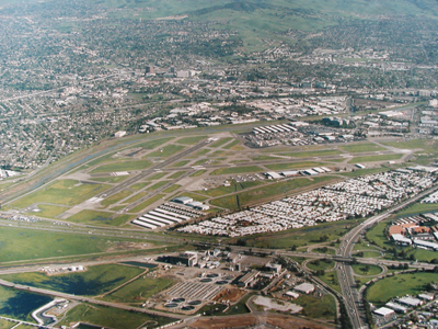
| BUCHANAN FIELD CONCORD CA |
| |
| Lat: N 3759.4 Long: W 12203.4 Elev: 26 Var: -13 Longest Runway: 5001 | ||
| Clr Del: 118.75 Dept. ATIS: 124.7 Arr. ATIS: 124.7 AWOS: 124.7 Ground: 121.9 Tower: 119.7/123.9 | ||
| |||||||||||||||||||||||||||||||||||||||||||||||||||||||||||||||||||||
| |||||||||||||||||||||||||||||||||||||||||||||||||||||||||||||||||||||
| |||||||||||||||||||||||||||||||||||||||||||||||||||||||||||||||||||||
| |||||||||||||||||||||||||||||||||||||||||||||||||||||||||||||||||||||
| |||||||||||||||||||||||||||||||||||||||||||||||||||||||||||||||||||||
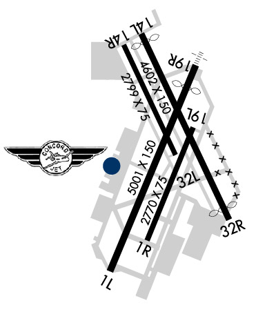
| Rwy | Rwy | |||||||
| 5001x150 | 5001' | 5001x150 | 4400' | 108.50 - 184° | ||||
| 2770x75 | 2770' | 2770x75 | 2770' | |||||
| 4602x150 | 4301' | 4602x150 | 4252' | |||||
| 2798x75 | 2798' | 2798x75 | 2798' | |||||
| Runway ID | Single Wheel | Double Wheel | Double Tandem Wheel | Dual Double Wheel |
| 01L/19R | 60,000 | 90,000 | 140,000 | N/A |
| 01R/19L | 17,000 | N/A | N/A | N/A |
| 14L/32R | 60,000 | 90,000 | 140,000 | N/A |
| 14R/32L | 12,500 | N/A | N/A | N/A |
| These numbers are Advisory and are not limits. The Airport Manager should have more accurate Weight Limits | ||||
 Airport Diagram might not be current. | |
| Facility Name: | BUCHANAN FLD |
| City Name: | CONCORD |
| County: | CONTRA COSTA |
| State abbrev: | CA |
| State Name: | CALIFORNIA |
| Ownership: | PUBLICLY OWNED |
| Use: | OPEN TO THE PUBLIC |
| Owner's Name: | CONTRA COSTA COUNTY |
| Address: | 550 SALLY RIDE DR. |
| CONCORD, CA 94520 | |
| Owner's Phone: | (925) 681-4200 |
| Manager's Name: | KEITH FREITAS; STEVE CALLAHAN (925) 383-1384 (CELL), MICHAEL VITALICH (925) 348-4014 (CELL), AND BIKRAMJIT BHULLAR (925) 405-7881 (CELL), CONTRA COSTA COUNTY, SUPERVISORS OF AIRPORT OPERATIONS, BUCHANAN FIELD AND BYRON AIRPORTS. OFFICE CONTACT NUMBER IS (925) 681-4200. |
| Address: | 550 SALLY RIDE DR. |
| CONCORD, CA 94520 | |
| Phone: | (925) 681-4200 |
| FAA Region: | WESTERN-PACIFIC |
| FAA Field Office: | SFO |
| Date | Sunrise | Sunset |
|---|---|---|
| 09/24/21 Friday | 6:58 | 19:02 |
| 09/25/21 Saturday | 6:58 | 19:01 |
| 09/26/21 Sunday | 6:59 | 18:59 |
| 09/27/21 Monday | 7:00 | 18:58 |
| 09/28/21 Tuesday | 7:01 | 18:56 |
| 09/29/21 Wednesday | 7:02 | 18:54 |
| 09/30/21 Thursday | 7:03 | 18:53 |
| 10/01/21 Friday | 7:04 | 18:51 |
| 10/02/21 Saturday | 7:05 | 18:50 |
| 10/03/21 Sunday | 7:06 | 18:48 |
| 10/04/21 Monday | 7:06 | 18:47 |
| 10/05/21 Tuesday | 7:07 | 18:45 |
| 10/06/21 Wednesday | 7:08 | 18:44 |
| 10/07/21 Thursday | 7:09 | 18:42 |
| Airport Attendance Schedule | 7 Days A Week 0700-1700 |
| Airport Status | OPERATIONAL (This Status can change at any time - please check NOTAMS) |
| Airport Lighting Schedule | ACTVT MALS RWY 19R 2200-0600; PAPI RWY 01L, 19R, & 32R - 119.7. REIL RWY 01L OFF WHEN ATCT CLSD. |
| Airport Storage Available | Tie Downs |
| Extra Services Available | Air Ambulance, Avionics, Charter, Flight Instruction, Aircraft Rental, Aircraft Sales |
| Wind Indicator | YES - (lighted) |
| Control Tower | YES |
| CTAF Frequency | 119.700 |
| Unicom Frequency | 122.950 |
| Rotating Beacon Color | CLEAR-GREEN (Light Land Airport) |
| Segmented Circle | YES |
| Landing Fee | NO |
| Airport Inspected | FEDERAL - performed by FAA AIRPORTS FIELD PERSONNEL |
| Inspection Date | 08/06/2019 |
| Type of Fuel Available | Grade 100LL, JET A-1 (icing inhibitor, freeze point -50C) |
| Airframe Repair Service | MAJOR |
| Power Plant Repair Service | MAJOR |
| Latitude | N3759.4 |
| Longitude | W12203.4 (ESTIMATED) |
| Arpt Elevation | 25ft (SURVEYED) |
| Magnetic Variation | 13E |
| 1 miles W | of CONCORD |
| Traffic Pattern Altitude | |
| Sectional Chart | SAN FRANCISCO |
| Operations (Reported) | Yearly | Avg. Daily |
|---|---|---|
| General Aviation Transient | 40927 | 112 |
| General Aviation Local | 44764 | 123 |
| Air Taxi | 4982 | 14 |
| Commerical | 4 | 0 |
| Commuter | 0 | 0 |
| Military | 9 | 0 |
| Aircraft based on Field | |
|---|---|
| General Aviation Singles | 284 |
| General Aviation Multi | 30 |
| Jet Aircraft | 17 |
| General Aviation Helicopters | 9 |
| Military Aircraft | 0 |
| Gliders | 0 |
| Ultralights | 0 |
| FSS on field | NO |
| FSS tie-in | OAKLAND |
| FSS Phone | 1-800-WX-BRIEF |
| Who issues Notams | CCR |
| Notam D service at airport | YES |
| ARTCC Name | OAKLAND |
| Airport Certification | CLSD TO ACR OPNS WITH MORE THAN 30 PSGR SEATS EXC PPR; CALL AMGR (925) 681-4200. ARFF SVCS AVBL 24 HRS WITH PRIOR APVL FROM ARPT ADMIN. |
| Aircraft Rescue & Firefighting Index | AIRPORT HAS A CERTIFICATE UNDER CFR PART 139 |
| Airport of Entry | No |
| Custom Landing Rights | No |
| Joint Civil/Military | No |
| Military Landing rights | YES |
| NATIONAL PLAN OF INTEGRATED AIRPORT SYSTEMS (NPIAS) |
| GRANT AGREEMENTS UNDER FAAP/ADAP/AIP |
| SURPLUS PROPERTY AGREEMENT UNDER REGULATION 16-WAA |
| ASSURANCES PURSUANT TO TITLE VI, CIVIL RIGHTS ACT OF 1964 |
| ARPT HAS NOISE ABATEMENT PROCEDURES CTC AMGR PRIOR TO ARR (925) 681-4200. |
| BIRDS ON & INVOF ARPT HEAVIEST CONCENTRATION NOV-MAR AND AFTER RAINSTORMS. |
| WHEN ATCT CLSD RYS 14L/32R; 14R/32L & 01R/19L CLSD. |
| NO TRAINING OPERATIONS MON-FRI 2200-0700; SAT SUN & HOL 2200-0800. |
| ARFF SVC AVBL UPON REQ WITH 24 HR NTC. |
| WHEN ATCT CLSD CALL TRAVIS APCH CTL (SUU) CLNC DEL 707-424-5111. |
| NOISE SENSITIVE AREA PRACTICE NOISE ABATEMENT (FLY QUIET) PROCS. |
| ARPT SFC CONDS NOT MNT 2200-0700. |
| LNDG FEE FOR COML OPNS & TIE DOWN FEE FOR OVERNIGHT PARKING. |
| +8 FT FENCE 110 FT BYD RY 01L TODA DSTC OF 5010 AND +7 FT FENCE 210 FT BYD RY 14L TODA DSTC OF 4601 FT ALONG THE EXTDD RY CNTRL. |
| RWY 01R/ 19LRWY 01R/19L PAVEMENT HAS HIGH SEVERITY BLOCK CRACKING, LONGL AND TRANSVERSE CRACKING, PATCHING, AND WEATHERING. |
Airport Communications & Frequencies:
| ||||||||||||||||||||||||||||
| Runway: 01L | Runway: 19R | ||
| Mag heading: | 11° | Mag heading: | 191° |
| Rwy Slope: | -.05% Down | Rwy Slope: | .05% Up |
| Approach: | Approach: | LDA/DME | |
| Pattern: | Left Traffic | Pattern: | Right Traffic; STD LEFT TFC WHEN ATCT CLSD. |
| Markings: | PRECISION INSTRUMENT | Markings: | PRECISION INSTRUMENT |
| Marking Condition: | GOOD | Marking Condition: | GOOD |
| Arresting Dev: | Arresting Dev: | ||
| Lat & Long: | N3758.9 W12203.7 | Lat. & Long.: | N3759.7 W12203.3 |
| Elev: | 23.6 ft. MSL | Elev: | 21.0 ft. MSL |
| TCH: | 40 ft. AGL | TCH: | 22 ft. AGL |
| Visual Glide Path: | 4.00 degrees | Visual Glide Path: | 3.00 degrees |
| Displaced Threshold: | No | Displaced Threshold: | 601 feet |
| Touchdown Zone: | YES | Touchdown Zone: | YES |
| Touchdown Elev.: | 23.6 feet | Touchdown Elev.: | 22.3 feet |
| Visual Glide Slope: | 4-Light PAPI on LEFT side of Runway; PAPI DOES NOT PROVIDE OBSTRUCTION CLEARANCE BYD 4.0 NM FROM THR. | Visual Glide Slope: | 4-Light PAPI on LEFT side of Runway |
| RVR Equipment: | RVR Equipment: | ||
| RVV Equipment: | NO | RVV Equipment: | NO |
| Approach Lights: | Approach Lights: | MALS - 1,400 foot medium intensity approach lighting system | |
| REIL: | YES | REIL: | NO |
| Centerline Lights: | NO | Centerline Lights: | NO |
| Touchdown lights: | NO | Touchdown lights: | NO |
| Runway Category: | Runway with a Visual Approach | Runway Category: | D |
| Declared Distances: | TORA:4701' TODA:5001' ASDA:4401' LDA:4401' | Declared Distances: | TORA:5001' TODA:5001' ASDA:5001' LDA:4401' |
| Obstructions: | TREE | Obstructions: | POLE |
| Marked: | NOT Marked/Lighted | Marked: | NOT Marked/Lighted |
| Clearance slope: | 22:1 | Clearance slope: | 15:1 |
| Obstruction height: | 58 feet AGL | Obstruction height: | 44 feet AGL |
| Dist. from runway: | 1480 feet | Dist. from runway: | 900 feet |
| Centerline offset: | 550 right of centerline | Centerline offset: | 590 feet left of centerline |
| Comments: | RWY 01L CLOSE IN OBSTN +8 FT FENCE 110 FT FROM RWY END, 100 FT RT | Comments: |
| Runway: 01R | Runway: 19L | ||
| Mag heading: | 11° | Mag heading: | 191° |
| Rwy Slope: | -.06% Down | Rwy Slope: | .06% Up |
| Approach: | Approach: | ||
| Pattern: | Right Traffic | Pattern: | Left Traffic |
| Markings: | BASIC | Markings: | BASIC |
| Marking Condition: | GOOD | Marking Condition: | GOOD |
| Arresting Dev: | Arresting Dev: | ||
| Lat & Long: | N3759.0 W12203.5 | Lat. & Long.: | N3759.5 W12203.3 |
| Elev: | 23.5 ft. MSL | Elev: | 21.7 ft. MSL |
| TCH: | TCH: | ||
| Visual Glide Path: | Visual Glide Path: | ||
| Displaced Threshold: | No | Displaced Threshold: | No |
| Touchdown Zone: | YES | Touchdown Zone: | YES |
| Touchdown Elev.: | 23.7 feet | Touchdown Elev.: | 23.7 feet |
| Visual Glide Slope: | Visual Glide Slope: | ||
| RVR Equipment: | RVR Equipment: | ||
| RVV Equipment: | NO | RVV Equipment: | NO |
| Approach Lights: | Approach Lights: | ||
| REIL: | NO | REIL: | NO |
| Centerline Lights: | NO | Centerline Lights: | NO |
| Touchdown lights: | NO | Touchdown lights: | NO |
| Runway Category: | Runway with a Visual Approach | Runway Category: | Runway with a Visual Approach |
| Declared Distances: | TORA:2770' TODA:2770' ASDA:2770' LDA:2770' | Declared Distances: | TORA:2770' TODA:2770' ASDA:2770' LDA:2770' |
| Obstructions: | TREE | Obstructions: | TREE |
| Marked: | NOT Marked/Lighted | Marked: | NOT Marked/Lighted |
| Clearance slope: | 30:1 | Clearance slope: | 26:1 |
| Obstruction height: | 50 feet AGL | Obstruction height: | 69 feet AGL |
| Dist. from runway: | 1675 feet | Dist. from runway: | 2000 feet |
| Centerline offset: | 150 right of centerline | Centerline offset: | 257 feet left of centerline |
| Comments: | Comments: |
| Runway: 14L | Runway: 32R | ||
| Mag heading: | 141° | Mag heading: | 321° |
| Rwy Slope: | .16% Up | Rwy Slope: | -.16% Down |
| Approach: | Approach: | ||
| Pattern: | Left Traffic | Pattern: | Right Traffic |
| Markings: | NONPRECISION INSTRUMENT | Markings: | NONPRECISION INSTRUMENT |
| Marking Condition: | GOOD | Marking Condition: | GOOD |
| Arresting Dev: | Arresting Dev: | ||
| Lat & Long: | N3759.8 W12203.5 | Lat. & Long.: | N3759.1 W12203.1 |
| Elev: | 18.2 ft. MSL | Elev: | 25.6 ft. MSL |
| TCH: | TCH: | 40 ft. AGL | |
| Visual Glide Path: | Visual Glide Path: | 4.00 degrees | |
| Displaced Threshold: | 301 feet | Displaced Threshold: | 350 feet |
| Touchdown Zone: | YES | Touchdown Zone: | YES |
| Touchdown Elev.: | 24.5 feet | Touchdown Elev.: | 25.4 feet |
| Visual Glide Slope: | Visual Glide Slope: | 4-Light PAPI on RIGHT side of Runway; PAPI DOES NOT PROVIDE OBSTRUCTION CLEARANCE BYD 4.0 NM FROM THR. | |
| RVR Equipment: | RVR Equipment: | ||
| RVV Equipment: | NO | RVV Equipment: | NO |
| Approach Lights: | Approach Lights: | ||
| REIL: | NO | REIL: | YES |
| Centerline Lights: | NO | Centerline Lights: | NO |
| Touchdown lights: | NO | Touchdown lights: | NO |
| Runway Category: | Runway with a Visual Approach | Runway Category: | Runway with a Visual Approach |
| Declared Distances: | TORA:4601' TODA:4601' ASDA:4001' LDA:3701' | Declared Distances: | TORA:4601' TODA:5081' ASDA:4481' LDA:4131' |
| Obstructions: | ROAD | Obstructions: | TREE |
| Marked: | NOT Marked/Lighted | Marked: | NOT Marked/Lighted |
| Clearance slope: | 43:1; APCH RATIO 50:1 TO DSPLCD THR. | Clearance slope: | 35:1; APCH RATIO 50:1 TO DSPLCD THR. |
| Obstruction height: | 15 feet AGL | Obstruction height: | 32 feet AGL |
| Dist. from runway: | 850 feet | Dist. from runway: | 1335 feet |
| Centerline offset: | Centerline offset: | 225 feet right of centerline | |
| Comments: | Comments: |
| Runway: 14R | Runway: 32L | ||
| Mag heading: | 141° | Mag heading: | 321° |
| Rwy Slope: | .18% Up | Rwy Slope: | -.18% Down |
| Approach: | Approach: | ||
| Pattern: | Right Traffic | Pattern: | Left Traffic |
| Markings: | BASIC | Markings: | BASIC |
| Marking Condition: | GOOD | Marking Condition: | GOOD |
| Arresting Dev: | Arresting Dev: | ||
| Lat & Long: | N3759.8 W12203.6 | Lat. & Long.: | N3759.3 W12203.4 |
| Elev: | 17.1 ft. MSL | Elev: | 22.2 ft. MSL |
| TCH: | TCH: | ||
| Visual Glide Path: | Visual Glide Path: | ||
| Displaced Threshold: | No | Displaced Threshold: | No |
| Touchdown Zone: | YES | Touchdown Zone: | YES |
| Touchdown Elev.: | 22.2 feet | Touchdown Elev.: | 22.2 feet |
| Visual Glide Slope: | Visual Glide Slope: | ||
| RVR Equipment: | RVR Equipment: | ||
| RVV Equipment: | NO | RVV Equipment: | NO |
| Approach Lights: | Approach Lights: | ||
| REIL: | NO | REIL: | NO |
| Centerline Lights: | NO | Centerline Lights: | NO |
| Touchdown lights: | NO | Touchdown lights: | NO |
| Runway Category: | Runway with a Visual Approach | Runway Category: | Runway with a Visual Approach |
| Declared Distances: | TORA:2799' TODA:2799' ASDA:2799' LDA:2799' | Declared Distances: | TORA:2799' TODA:2799' ASDA:2799' LDA:2799' |
| Obstructions: | ROAD; LIGHT | Obstructions: | OTHER |
| Marked: | NOT Marked/Lighted | Marked: | NOT Marked/Lighted |
| Clearance slope: | 25:1 | Clearance slope: | 23:1 |
| Obstruction height: | 15 feet AGL | Obstruction height: | 46 feet AGL |
| Dist. from runway: | 580 feet | Dist. from runway: | 1260 feet |
| Centerline offset: | Centerline offset: | 175 feet left of centerline | |
| Comments: | Comments: |
Thanks for using FltPlan.com
all rights reserved © 1999-2021 by Flight Plan LLC