
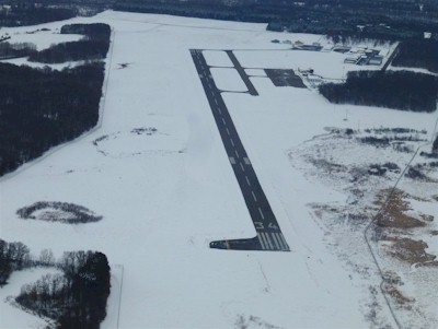
| CAMBRIDGE MUNI CAMBRIDGE MN |
| |
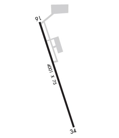
| Lat: N 4533.4 Long: W 09315.9 Elev: 945 Var: -01 Longest Runway: 4001 | ||
| AWOS: 121.12 CTAF: 122.8 | ||
| ||||||||||||||||||||||||||||||||||||||||||||
| ||||||||||||||||||||||||||||||||||||||||||||
| ||||||||||||||||||||||||||||||||||||||||||||
| Rwy | Rwy | |||||||
| 4001x75 | 4001' | 4001x75 | 4001' | |||||
| Runway ID | Single Wheel | Double Wheel | Double Tandem Wheel | Dual Double Wheel |
| 16/34 | 12,500 | N/A | N/A | N/A |
| These numbers are Advisory and are not limits. The Airport Manager should have more accurate Weight Limits | ||||
 Airport Diagram might not be current. | |
| Facility Name: | CAMBRIDGE MUNI |
| City Name: | CAMBRIDGE |
| County: | ISANTI |
| State abbrev: | MN |
| State Name: | MINNESOTA |
| Ownership: | PUBLICLY OWNED |
| Use: | OPEN TO THE PUBLIC |
| Owner's Name: | CITY OF CAMBRIDGE |
| Address: | 300 3RD AVE NE |
| CAMBRIDGE, MN 55008-9013 | |
| Owner's Phone: | 612-689-3211 |
| Manager's Name: | LUCAS MILZ |
| Address: | CITY OF CAMBRIDGE, 300 3RD AVE NE |
| CAMBRIDGE, MN 55008-9013 | |
| Phone: | 763-552-3279; CELL 612-221-9878. |
| FAA Region: | GREAT LAKES |
| FAA Field Office: | DMA |
| Date | Sunrise | Sunset |
|---|---|---|
| 06/08/26 Monday | 5:25 | 21:00 |
| 06/09/26 Tuesday | 5:24 | 21:01 |
| 06/10/26 Wednesday | 5:24 | 21:01 |
| 06/11/26 Thursday | 5:24 | 21:02 |
| 06/12/26 Friday | 5:24 | 21:02 |
| 06/13/26 Saturday | 5:24 | 21:03 |
| 06/14/26 Sunday | 5:23 | 21:03 |
| 06/15/26 Monday | 5:23 | 21:04 |
| 06/16/26 Tuesday | 5:23 | 21:04 |
| 06/17/26 Wednesday | 5:23 | 21:04 |
| 06/18/26 Thursday | 5:24 | 21:05 |
| 06/19/26 Friday | 5:24 | 21:05 |
| 06/20/26 Saturday | 5:24 | 21:05 |
| 06/21/26 Sunday | 5:24 | 21:06 |
| Airport Attendance Schedule | UNATTENDED |
| Airport Status | OPERATIONAL (This Status can change at any time - please check NOTAMS) |
| Airport Lighting Schedule | ACTVT OR INCR INTST REIL RWY 34; PAPI RWY 16 & 34; MIRL RWY 16/34 - CTAF. MIRL RWY 16/34 PRESET LOW INTST SS-SR. |
| Airport Storage Available | Tie Downs, Hanger |
| Extra Services Available | Flight Instruction, Aircraft Rental, Aircraft Sales, Annual Surveying |
| Wind Indicator | YES - (lighted) |
| Control Tower | NO |
| CTAF Frequency | 122.800 |
| Unicom Frequency | 122.800 |
| Rotating Beacon Color | WG |
| Segmented Circle | NO |
| Landing Fee | NO |
| Airport Inspected | STATE - performed by STATE AERONAUTICAL PERSONNEL |
| Inspection Date | 06/11/2024 |
| Type of Fuel Available | Grade 100LL, JET A (freeze point -40C); -10FUEL AVBL H24 SELF SER VIA CREDIT CARD. |
| Airframe Repair Service | NONE |
| Power Plant Repair Service | NONE |
| Latitude | N4533.4 |
| Longitude | W09315.9 (ESTIMATED) |
| Arpt Elevation | 945ft (SURVEYED) |
| Magnetic Variation | 01E |
| 2 miles SW | of CAMBRIDGE |
| Traffic Pattern Altitude | |
| Sectional Chart | TWIN CITIES |
| Operations (Reported) | Yearly | Avg. Daily |
|---|---|---|
| General Aviation Transient | 0 | 0 |
| General Aviation Local | 0 | 0 |
| Air Taxi | 0 | 0 |
| Commerical | 0 | 0 |
| Commuter | 0 | 0 |
| Military | 0 | 0 |
| Aircraft based on Field | |
|---|---|
| General Aviation Singles | 0 |
| General Aviation Multi | 0 |
| Jet Aircraft | 0 |
| General Aviation Helicopters | 0 |
| Military Aircraft | 0 |
| Gliders | 0 |
| Ultralights | 0 |
| FSS on field | NO |
| FSS tie-in | PRINCETON |
| FSS Phone | 1-800-WX-BRIEF |
| Who issues Notams | CBG |
| Notam D service at airport | YES |
| ARTCC Name | MINNEAPOLIS |
| Airport Certification | |
| Aircraft Rescue & Firefighting Index | None |
| Airport of Entry | No |
| Custom Landing Rights | No |
| Joint Civil/Military | No |
| Military Landing rights | YES |
| NATIONAL PLAN OF INTEGRATED AIRPORT SYSTEMS (NPIAS) |
| GRANT AGREEMENTS UNDER FAAP/ADAP/AIP |
| ASSURANCES PURSUANT TO TITLE VI, CIVIL RIGHTS ACT OF 1964 |
| MIGRATORY WATERFOWL & DEER ON & INVOF ARPT. |
| FOR NOISE ABATEMENT RWY 16 DEPS FLY RWY HDG TO 1945 FT MSL (1000 FT AGL) & 2 NM BFR LEFT TURN. |
| CODE FOR AD BLDG: LAST 3 DIGITS OF EMERG FREQ. |
| FOR CD CTC MINNEAPOLIS ARTCC AT 651-463-5588. |
Airport Communications & Frequencies:
| |||||||||
| Runway: 16 | Runway: 34 | ||
| Mag heading: | 162° | Mag heading: | 342° |
| Rwy Slope: | -.07% Down | Rwy Slope: | .07% Up |
| Approach: | Approach: | ||
| Pattern: | Left Traffic | Pattern: | Left Traffic |
| Markings: | NONPRECISION INSTRUMENT | Markings: | NONPRECISION INSTRUMENT |
| Marking Condition: | GOOD | Marking Condition: | GOOD |
| Arresting Dev: | Arresting Dev: | ||
| Lat & Long: | N4533.8 W09316.0 | Lat. & Long.: | N4533.1 W09315.7 |
| Elev: | 942.3 ft. MSL | Elev: | 939.3 ft. MSL |
| TCH: | 37 ft. AGL | TCH: | 41 ft. AGL |
| Visual Glide Path: | 3.00 degrees | Visual Glide Path: | 3.00 degrees |
| Displaced Threshold: | No | Displaced Threshold: | No |
| Touchdown Zone: | YES | Touchdown Zone: | YES |
| Touchdown Elev.: | 945.4 feet | Touchdown Elev.: | 945.4 feet |
| Visual Glide Slope: | 4-Light PAPI on RIGHT side of Runway | Visual Glide Slope: | 4-Light PAPI on LEFT side of Runway |
| RVR Equipment: | RVR Equipment: | ||
| RVV Equipment: | NO | RVV Equipment: | NO |
| Approach Lights: | Approach Lights: | ||
| REIL: | NO | REIL: | YES |
| Centerline Lights: | NO | Centerline Lights: | NO |
| Touchdown lights: | NO | Touchdown lights: | NO |
| Runway Category: | Runway with a Non-precision Approach | Runway Category: | Runway with a Non-precision Approach |
| Declared Distances: | Declared Distances: | ||
| Obstructions: | Obstructions: | TREES | |
| Marked: | Marked: | NOT Marked/Lighted | |
| Clearance slope: | 20:1 | Clearance slope: | 17:1 |
| Obstruction height: | Obstruction height: | 61 feet AGL | |
| Dist. from runway: | Dist. from runway: | 1264 feet | |
| Centerline offset: | Centerline offset: | 384 feet right of centerline | |
| Comments: | Comments: |
Thanks for using FltPlan.com
all rights reserved © 1999-2026 by Flight Plan LLC