
| AKRON-CANTON RGNL AKRON OH |
| |
| Lat: N 4054.9 Long: W 08126.6 Elev: 1226 Var: +07 Longest Runway: 8204 | ||
| Clr Del: 132.05 Dept. ATIS: 121.05 Arr. ATIS: 121.05 Ground: 121.7 Tower: 134.75 | ||
| ||||||||||||||||||||||||||||||||||||||||||||||||||||||||||||||||||||
| ||||||||||||||||||||||||||||||||||||||||||||||||||||||||||||||||||||
| ||||||||||||||||||||||||||||||||||||||||||||||||||||||||||||||||||||
| ||||||||||||||||||||||||||||||||||||||||||||||||||||||||||||||||||||
| Rwy | Rwy | |||||||
| 7601x150 | 7601' | 109.50 - 009° | 7601x150 | 7000' | 109.50 - 189° | |||
| 8204x150 | 8204' | 108.30 - 054° | 8204x150 | 8204' | 108.30 - 234° | |||
| Runway ID | Single Wheel | Double Wheel | Double Tandem Wheel | Dual Double Wheel |
| 01/19 | 120,000 | 160,000 | 250,000 | N/A |
| 05/23 | 120,000 | 160,000 | 250,000 | N/A |
| These numbers are Advisory and are not limits. The Airport Manager should have more accurate Weight Limits | ||||
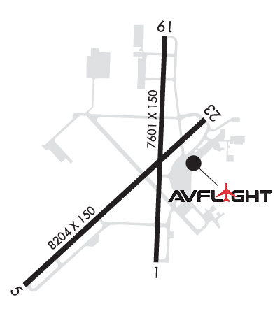 Airport Diagram might not be current. | |
| Facility Name: | AKRON-CANTON RGNL |
| City Name: | AKRON |
| County: | SUMMIT |
| State abbrev: | OH |
| State Name: | OHIO |
| Ownership: | PUBLICLY OWNED |
| Use: | OPEN TO THE PUBLIC |
| Owner's Name: | AKRON CANTON RGNL ARPT AUTHORITY |
| Address: | 5400 LAUBY RD |
| NORTH CANTON, OH 44720 | |
| Owner's Phone: | 330-499-4059 |
| Manager's Name: | RENATO CAMACHO |
| Address: | 5400 LAUBY RD |
| NORTH CANTON, OH 44720 | |
| Phone: | 330-754-5233 |
| FAA Region: | GREAT LAKES |
| FAA Field Office: | DET |
| Date | Sunrise | Sunset |
|---|---|---|
| 03/17/26 Tuesday | 7:35 | 19:34 |
| 03/18/26 Wednesday | 7:33 | 19:36 |
| 03/19/26 Thursday | 7:31 | 19:37 |
| 03/20/26 Friday | 7:30 | 19:38 |
| 03/21/26 Saturday | 7:28 | 19:39 |
| 03/22/26 Sunday | 7:26 | 19:40 |
| 03/23/26 Monday | 7:25 | 19:41 |
| 03/24/26 Tuesday | 7:23 | 19:42 |
| 03/25/26 Wednesday | 7:21 | 19:43 |
| 03/26/26 Thursday | 7:20 | 19:44 |
| 03/27/26 Friday | 7:18 | 19:45 |
| 03/28/26 Saturday | 7:16 | 19:46 |
| 03/29/26 Sunday | 7:15 | 19:47 |
| 03/30/26 Monday | 7:13 | 19:48 |
| Airport Attendance Schedule | CONTINUOUS |
| Airport Status | OPERATIONAL (This Status can change at any time - please check NOTAMS) |
| Airport Lighting Schedule | |
| Airport Storage Available | Tie Downs, Hanger |
| Extra Services Available | Air Freight, Avionics, Cargo Handling, Charter, Flight Instruction, Aircraft Rental, Aircraft Sales |
| Wind Indicator | YES - (lighted) |
| Control Tower | YES |
| CTAF Frequency | |
| Unicom Frequency | 122.950 |
| Rotating Beacon Color | WG |
| Segmented Circle | NO |
| Landing Fee | YES; MULTI ENG ONLY |
| Airport Inspected | FEDERAL - performed by FAA AIRPORTS FIELD PERSONNEL |
| Inspection Date | 05/15/2024 |
| Type of Fuel Available | Grade 100LL, JET A (freeze point -40C) |
| Airframe Repair Service | MAJOR |
| Power Plant Repair Service | MAJOR |
| Latitude | N4054.9 |
| Longitude | W08126.6 (ESTIMATED) |
| Arpt Elevation | 1225ft (SURVEYED) |
| Magnetic Variation | 07W |
| 10 miles SE | of AKRON |
| Traffic Pattern Altitude | |
| Sectional Chart | DETROIT |
| Operations (Reported) | Yearly | Avg. Daily |
|---|---|---|
| General Aviation Transient | 0 | 0 |
| General Aviation Local | 0 | 0 |
| Air Taxi | 0 | 0 |
| Commerical | 0 | 0 |
| Commuter | 0 | 0 |
| Military | 0 | 0 |
| Aircraft based on Field | |
|---|---|
| General Aviation Singles | 0 |
| General Aviation Multi | 0 |
| Jet Aircraft | 0 |
| General Aviation Helicopters | 0 |
| Military Aircraft | 0 |
| Gliders | 0 |
| Ultralights | 0 |
| FSS on field | NO |
| FSS tie-in | CLEVELAND |
| FSS Phone | 1-800-WX-BRIEF |
| Who issues Notams | CAK |
| Notam D service at airport | YES |
| ARTCC Name | CLEVELAND |
| Airport Certification | AIRPORT RECEIVING SCHEDULED AIR CARRIER SERVICE FROM CARRIERS CERTIFICATED BY THE CIVIL AERONAUTICS BOARD; ARFF SVC NOT AVBL 0100-0500 LCL DLY. ONE HOUR PPR FOR UNSKED ACR OPNS; CALL AMGR 330-499-4059. |
| Aircraft Rescue & Firefighting Index | AIRPORT HAS A CERTIFICATE UNDER CFR PART 139 |
| Airport of Entry | No |
| Custom Landing Rights | YES |
| Joint Civil/Military | No |
| Military Landing rights | YES |
| NATIONAL PLAN OF INTEGRATED AIRPORT SYSTEMS (NPIAS) |
| GRANT AGREEMENTS UNDER FAAP/ADAP/AIP |
| ASSURANCES PURSUANT TO TITLE VI, CIVIL RIGHTS ACT OF 1964 |
| AGREEMENT UNDER DLAND OR DCLA HAS EXPIRED. |
| DEER & BIRDS ON & INVOF ARPT. |
| ALL ACFT TAXIING ON AIR CAMIS RAMP & NORTH HANGAR AREAS NOT VISIBLE FM ATCT. |
| TWY E EAST OF TWY B CLSD TO ACFT OVER 118 FT WINGSPAN. |
| FOR CD CTC CLEVELAND ARTCC AT 440-774-0223. |
| RWY 01/1 9 PCR VALUE: 410/F/B/X/U |
| RWY 05/2 3 PCR VALUE: 410/F/B/X/U |
Airport Communications & Frequencies:
| |||||||||||||||||||||||||||||||||||||||||||||||
| Runway: 01 | Runway: 19 | ||
| Mag heading: | 9° | Mag heading: | 189° |
| Rwy Slope: | .07% Up | Rwy Slope: | -.07% Down |
| Approach: | ILS | Approach: | ILS |
| Pattern: | Left Traffic | Pattern: | Left Traffic |
| Markings: | PRECISION INSTRUMENT | Markings: | PRECISION INSTRUMENT |
| Marking Condition: | GOOD | Marking Condition: | GOOD |
| Arresting Dev: | Arresting Dev: | ||
| Lat & Long: | N4054.4 W08126.5 | Lat. & Long.: | N4055.7 W08126.4 |
| Elev: | 1208.6 ft. MSL | Elev: | 1214.0 ft. MSL |
| TCH: | TCH: | 53 ft. AGL | |
| Visual Glide Path: | Visual Glide Path: | 3.00 degrees | |
| Displaced Threshold: | No | Displaced Threshold: | 601 feet |
| Touchdown Zone: | YES | Touchdown Zone: | YES |
| Touchdown Elev.: | 1208.7 feet | Touchdown Elev.: | 1217.8 feet |
| Visual Glide Slope: | Visual Glide Slope: | 4-Light PAPI on LEFT side of Runway | |
| RVR Equipment: | TOUCHDOWN-ROLLOUT | RVR Equipment: | TOUCHDOWN-ROLLOUT |
| RVV Equipment: | NO | RVV Equipment: | NO |
| Approach Lights: | MALSR - 1,400 foot medium intensity approach lighting system with runway alignment indicator lights | Approach Lights: | MALSR - 1,400 foot medium intensity approach lighting system with runway alignment indicator lights |
| REIL: | NO | REIL: | NO |
| Centerline Lights: | NO | Centerline Lights: | NO |
| Touchdown lights: | NO | Touchdown lights: | NO |
| Runway Category: | Precision Instrument Runway | Runway Category: | Precision Instrument Runway |
| Declared Distances: | TORA:7601' TODA:7601' ASDA:7007' LDA:7007' | Declared Distances: | TORA:7601' TODA:7601' ASDA:7601' LDA:7007' |
| Runway: 05 | Runway: 23 | ||
| Mag heading: | 54° | Mag heading: | 234° |
| Rwy Slope: | .56% Up | Rwy Slope: | -.56% Down |
| Approach: | ILS/DME | Approach: | ILS/DME |
| Pattern: | Left Traffic | Pattern: | Left Traffic |
| Markings: | PRECISION INSTRUMENT | Markings: | PRECISION INSTRUMENT |
| Marking Condition: | GOOD | Marking Condition: | GOOD |
| Arresting Dev: | Arresting Dev: | ||
| Lat & Long: | N4054.3 W08127.4 | Lat. & Long.: | N4055.2 W08126.1 |
| Elev: | 1179.6 ft. MSL | Elev: | 1225.5 ft. MSL |
| TCH: | 50 ft. AGL | TCH: | 47 ft. AGL |
| Visual Glide Path: | 3.00 degrees | Visual Glide Path: | 3.00 degrees |
| Displaced Threshold: | No | Displaced Threshold: | No |
| Touchdown Zone: | YES | Touchdown Zone: | YES |
| Touchdown Elev.: | 1198.6 feet | Touchdown Elev.: | 1225.5 feet |
| Visual Glide Slope: | 4-Light PAPI on LEFT side of Runway | Visual Glide Slope: | 4-Light PAPI on LEFT side of Runway |
| RVR Equipment: | TOUCHDOWN-ROLLOUT | RVR Equipment: | TOUCHDOWN-ROLLOUT |
| RVV Equipment: | NO | RVV Equipment: | NO |
| Approach Lights: | MALSR - 1,400 foot medium intensity approach lighting system with runway alignment indicator lights | Approach Lights: | MALSR - 1,400 foot medium intensity approach lighting system with runway alignment indicator lights |
| REIL: | NO | REIL: | NO |
| Centerline Lights: | NO | Centerline Lights: | NO |
| Touchdown lights: | NO | Touchdown lights: | NO |
| Runway Category: | Precision Instrument Runway | Runway Category: | Precision Instrument Runway |
| Declared Distances: | TORA:8204' TODA:8204' ASDA:8204' LDA:8204' | Declared Distances: | TORA:8204' TODA:8204' ASDA:8204' LDA:8204' |
Thanks for using FltPlan.com
all rights reserved © 1999-2026 by Flight Plan LLC


