
| WEXFORD COUNTY CADILLAC MI |
| |
| Lat: N 4416.5 Long: W 08525.1 Elev: 1307 Var: +04 Longest Runway: 5000 | ||
| Clr Del: 121.72 (GCO) AWOS: 128.32 CTAF: 122.8 | ||
| ||||||
| ||||||
|
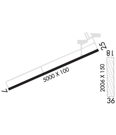
| Rwy | Rwy | |||||||
| 5000x100 | 5000' | 108.55 - 070° | 5000x100 | 5000' | ||||
| 2006x150 | 2006' | 2006x150 | 2006' | |||||
| Runway ID | Single Wheel | Double Wheel | Double Tandem Wheel | Dual Double Wheel |
| 07/25 | 30,000 | 45,000 | N/A | N/A |
| 18/36 | N/A | N/A | N/A | N/A |
| These numbers are Advisory and are not limits. The Airport Manager should have more accurate Weight Limits | ||||
 Airport Diagram might not be current. | |
| Facility Name: | WEXFORD COUNTY |
| City Name: | CADILLAC |
| County: | WEXFORD |
| State abbrev: | MI |
| State Name: | MICHIGAN |
| Ownership: | PUBLICLY OWNED |
| Use: | OPEN TO THE PUBLIC |
| Owner's Name: | WEXFORD/CO ARPT AUTH |
| Address: | 8040 EAST 34TH ROAD |
| CADILLAC, MI 49601 | |
| Owner's Phone: | 231-779-9525 |
| Manager's Name: | STEVE BUJALSKI |
| Address: | 8040 E. 34TH RD. |
| CADILLAC, MI 49601 | |
| Phone: | 231-779-9525 |
| FAA Region: | GREAT LAKES |
| FAA Field Office: | DET |
| Date | Sunrise | Sunset |
|---|---|---|
| 09/24/21 Friday | 7:31 | 19:36 |
| 09/25/21 Saturday | 7:32 | 19:34 |
| 09/26/21 Sunday | 7:33 | 19:32 |
| 09/27/21 Monday | 7:34 | 19:30 |
| 09/28/21 Tuesday | 7:36 | 19:28 |
| 09/29/21 Wednesday | 7:37 | 19:27 |
| 09/30/21 Thursday | 7:38 | 19:25 |
| 10/01/21 Friday | 7:39 | 19:23 |
| 10/02/21 Saturday | 7:40 | 19:21 |
| 10/03/21 Sunday | 7:42 | 19:19 |
| 10/04/21 Monday | 7:43 | 19:17 |
| 10/05/21 Tuesday | 7:44 | 19:16 |
| 10/06/21 Wednesday | 7:45 | 19:14 |
| 10/07/21 Thursday | 7:46 | 19:12 |
| Airport Attendance Schedule | MON-FRI 0700-1700, MAY-SEP SAT-SUN 0800-1200, OCT-APR SAT-SUN UNATND; AFTR HR ATTENDANCE AVBL ON REQ 231-779-9211, CALL-IN FEE. UNATNDD MAJ. HOL. |
| Airport Status | OPERATIONAL (This Status can change at any time - please check NOTAMS) |
| Airport Lighting Schedule | ACTVT MALSF RY 07; REILS RY 07/25 VASI RY 07; PAPI RY 25; HIRL RY 07/25 - CTAF. |
| Airport Storage Available | Tie Downs, Hanger |
| Extra Services Available | Charter, Glider, Flight Instruction, Aircraft Rental, Glider Towing |
| Wind Indicator | YES - (lighted) |
| Control Tower | NO |
| CTAF Frequency | 122.800 |
| Unicom Frequency | 122.800 |
| Rotating Beacon Color | CLEAR-GREEN (Light Land Airport) |
| Segmented Circle | YES |
| Landing Fee | NO; LDG FEE FOR COML OPNS WAIVED WITH MINIMUM FUEL PURCHASE. |
| Airport Inspected | STATE - performed by STATE AERONAUTICAL PERSONNEL |
| Inspection Date | 10/11/2017 |
| Type of Fuel Available | Grade 100LL, JET A (freeze point -40C); -1024 HR SELF SVC. |
| Airframe Repair Service | MAJOR |
| Power Plant Repair Service | MAJOR |
| Latitude | N4416.5 |
| Longitude | W08525.1 (ESTIMATED) |
| Arpt Elevation | 1306ft (SURVEYED) |
| Magnetic Variation | 04W |
| 2 miles N | of CADILLAC |
| Traffic Pattern Altitude | |
| Sectional Chart | GREEN BAY |
| Operations (Reported) | Yearly | Avg. Daily |
|---|---|---|
| General Aviation Transient | 4000 | 11 |
| General Aviation Local | 4000 | 11 |
| Air Taxi | 100 | 0 |
| Commerical | 0 | 0 |
| Commuter | 0 | 0 |
| Military | 50 | 0 |
| Aircraft based on Field | |
|---|---|
| General Aviation Singles | 35 |
| General Aviation Multi | 3 |
| Jet Aircraft | 0 |
| General Aviation Helicopters | 1 |
| Military Aircraft | 0 |
| Gliders | 7 |
| Ultralights | 0 |
| FSS on field | NO |
| FSS tie-in | LANSING |
| FSS Phone | 1-800-WX-BRIEF |
| Who issues Notams | CAD |
| Notam D service at airport | YES |
| ARTCC Name | MINNEAPOLIS |
| Airport Certification | |
| Aircraft Rescue & Firefighting Index | None |
| Airport of Entry | No |
| Custom Landing Rights | No |
| Joint Civil/Military | No |
| Military Landing rights | YES |
| NATIONAL PLAN OF INTEGRATED AIRPORT SYSTEMS (NPIAS) |
| GRANT AGREEMENTS UNDER FAAP/ADAP/AIP |
| ASSURANCES PURSUANT TO TITLE VI, CIVIL RIGHTS ACT OF 1964 |
| GCO AVBL ON FREQ 121.725 THRU MINNEAPOLIS ARTCC CD & LANSING FSS. |
| ADMIN BLDG ACCESS, EAST DOOR, DEPRESS 5-3-2-1. |
| GLIDER & ULTRALIGHT ACTIVITY ON AND INVOF ARPT APR-OCT. |
| FOR CD IF UNA VIA GCO CTC MINNEAPOLIS ARTCC AT 651-463-5588. |
| DEER ON & INVOF ARPT. |
| RWY 18/3 6 CLSD DEC THRU MAR & WHEN SNOW COVERED EXCEPT FOR SKI EQUIPPED ACFT. |
Airport Communications & Frequencies:
| |||||||||
| Runway: 07 | Runway: 25 | ||
| Mag heading: | 70° | Mag heading: | 250° |
| Rwy Slope: | -.17% Down | Rwy Slope: | .17% Up |
| Approach: | ILS/DME | Approach: | |
| Pattern: | Left Traffic | Pattern: | Left Traffic |
| Markings: | PRECISION INSTRUMENT | Markings: | PRECISION INSTRUMENT |
| Marking Condition: | GOOD | Marking Condition: | GOOD |
| Arresting Dev: | Arresting Dev: | ||
| Lat & Long: | N4416.4 W08525.9 | Lat. & Long.: | N4416.7 W08524.8 |
| Elev: | 1306.2 ft. MSL | Elev: | 1297.7 ft. MSL |
| TCH: | 41 ft. AGL | TCH: | 56 ft. AGL |
| Visual Glide Path: | 3.00 degrees | Visual Glide Path: | 3.00 degrees |
| Displaced Threshold: | No | Displaced Threshold: | No |
| Touchdown Zone: | YES | Touchdown Zone: | YES |
| Touchdown Elev.: | 1306.5 feet | Touchdown Elev.: | 1305.2 feet |
| Visual Glide Slope: | 2-Box VASI on LEFT side of Runway | Visual Glide Slope: | 4-Light PAPI on LEFT side of Runway |
| RVR Equipment: | RVR Equipment: | ||
| RVV Equipment: | NO | RVV Equipment: | NO |
| Approach Lights: | MALSF - 1,400 foot medium intensity approach lighting system with sequenced flashers | Approach Lights: | |
| REIL: | YES | REIL: | YES |
| Centerline Lights: | NO | Centerline Lights: | NO |
| Touchdown lights: | NO | Touchdown lights: | NO |
| Runway Category: | Precision Instrument Runway | Runway Category: | Runway with a Non-precision Approach having visibility minimums greater than 3/4 mile |
| Declared Distances: | Declared Distances: | ||
| Obstructions: | Obstructions: | RR | |
| Marked: | Marked: | NOT Marked/Lighted | |
| Clearance slope: | 50:1 | Clearance slope: | 29:1 |
| Obstruction height: | Obstruction height: | 23 feet AGL | |
| Dist. from runway: | Dist. from runway: | 870 feet | |
| Centerline offset: | Centerline offset: | 610 feet left of centerline | |
| Comments: | Comments: |
| Runway: 18 | Runway: 36 | ||
| Mag heading: | 183° | Mag heading: | 3° |
| Rwy Slope: | .13% Up | Rwy Slope: | -.13% Down |
| Approach: | Approach: | ||
| Pattern: | Left Traffic | Pattern: | Left Traffic |
| Markings: | NONE | Markings: | NONE |
| Marking Condition: | 18/36 MARKED WITH 3 FT YELLOW CONES. | Marking Condition: | |
| Arresting Dev: | Arresting Dev: | ||
| Lat & Long: | N4416.6 W08524.7 | Lat. & Long.: | N4416.3 W08524.7 |
| Elev: | 1293.6 ft. MSL | Elev: | 1296.3 ft. MSL |
| TCH: | TCH: | ||
| Visual Glide Path: | Visual Glide Path: | ||
| Displaced Threshold: | No | Displaced Threshold: | No |
| Touchdown Zone: | YES | Touchdown Zone: | YES |
| Touchdown Elev.: | 1296.6 feet | Touchdown Elev.: | 1296.6 feet |
| Visual Glide Slope: | Visual Glide Slope: | ||
| RVR Equipment: | RVR Equipment: | ||
| RVV Equipment: | NO | RVV Equipment: | NO |
| Approach Lights: | Approach Lights: | ||
| REIL: | NO | REIL: | NO |
| Centerline Lights: | NO | Centerline Lights: | NO |
| Touchdown lights: | NO | Touchdown lights: | NO |
| Runway Category: | Runway with a Visual Approach | Runway Category: | Runway with a Visual Approach |
| Declared Distances: | Declared Distances: | ||
| Obstructions: | Obstructions: | STACK | |
| Marked: | Marked: | LIGHTED | |
| Clearance slope: | 50:1 | Clearance slope: | 23:1 |
| Obstruction height: | Obstruction height: | 112 feet AGL | |
| Dist. from runway: | Dist. from runway: | 2630 feet | |
| Centerline offset: | Centerline offset: | 95 feet right of centerline | |
| Comments: | Comments: |
Thanks for using FltPlan.com
all rights reserved © 1999-2021 by Flight Plan LLC
