
| DOWAGIAC MUNI DOWAGIAC MI |
| |
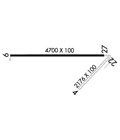
| Lat: N 4159.6 Long: W 08607.7 Elev: 747 Var: +05 Longest Runway: 4700 | ||
| CTAF: 122.8 | ||
| ||||||||||||||||||||||||||||||||||||||||||||
| ||||||||||||||||||||||||||||||||||||||||||||
| Rwy | Rwy | |||||||
| 2176x100 | 2176' | 2176x100 | 1788' | |||||
| 4700x100 | 4700' | 4700x100 | 4700' | |||||
| Runway ID | Single Wheel | Double Wheel | Double Tandem Wheel | Dual Double Wheel |
| 04/22 | N/A | N/A | N/A | N/A |
| 09/27 | 30,000 | 60,000 | N/A | N/A |
| These numbers are Advisory and are not limits. The Airport Manager should have more accurate Weight Limits | ||||
 Airport Diagram might not be current. | |
| Facility Name: | DOWAGIAC MUNI |
| City Name: | DOWAGIAC |
| County: | CASS |
| State abbrev: | MI |
| State Name: | MICHIGAN |
| Ownership: | PUBLICLY OWNED |
| Use: | OPEN TO THE PUBLIC |
| Owner's Name: | CITY OF DOWAGIAC |
| Address: | 241 S. FRONT ST., 241 S FRONT ST |
| DOWAGIAC, MI 49047-1738 | |
| Owner's Phone: | 269-782-2195 |
| Manager's Name: | OSCAR AZEVEDO |
| Address: | 241 S. FRONT ST., 241 S FRONT ST |
| DOWAGIAC, MI 49047-1738 | |
| Phone: | 269-591-0054 |
| FAA Region: | GREAT LAKES |
| FAA Field Office: | DET |
| Date | Sunrise | Sunset |
|---|---|---|
| 06/07/26 Sunday | 6:09 | 21:18 |
| 06/08/26 Monday | 6:09 | 21:18 |
| 06/09/26 Tuesday | 6:09 | 21:19 |
| 06/10/26 Wednesday | 6:09 | 21:19 |
| 06/11/26 Thursday | 6:09 | 21:20 |
| 06/12/26 Friday | 6:08 | 21:20 |
| 06/13/26 Saturday | 6:08 | 21:21 |
| 06/14/26 Sunday | 6:08 | 21:21 |
| 06/15/26 Monday | 6:08 | 21:22 |
| 06/16/26 Tuesday | 6:08 | 21:22 |
| 06/17/26 Wednesday | 6:08 | 21:22 |
| 06/18/26 Thursday | 6:08 | 21:23 |
| 06/19/26 Friday | 6:09 | 21:23 |
| 06/20/26 Saturday | 6:09 | 21:23 |
| Airport Attendance Schedule | UNATTENDED |
| Airport Status | OPERATIONAL (This Status can change at any time - please check NOTAMS) |
| Airport Lighting Schedule | ACTVT MIRL RWY 09/27; PAPI RWYS 09 & RWY 27; & REIL RWYS 09 & 27 - CTAF. |
| Airport Storage Available | Tie Downs |
| Extra Services Available | Flight Instruction, Aircraft Rental |
| Wind Indicator | YES - (lighted) |
| Control Tower | NO |
| CTAF Frequency | 122.800 |
| Unicom Frequency | 122.800 |
| Rotating Beacon Color | WG |
| Segmented Circle | YES |
| Landing Fee | NO |
| Airport Inspected | STATE - performed by STATE AERONAUTICAL PERSONNEL |
| Inspection Date | 01/08/2025 |
| Type of Fuel Available | Grade 100LL; -10SELF SVC FUEL AVBL 24 HR. |
| Airframe Repair Service | None |
| Power Plant Repair Service | None |
| Latitude | N4159.6 |
| Longitude | W08607.7 (ESTIMATED) |
| Arpt Elevation | 747ft (SURVEYED) |
| Magnetic Variation | 05W |
| 1 miles NW | of DOWAGIAC |
| Traffic Pattern Altitude | 800 |
| Sectional Chart | CHICAGO |
| Operations (Reported) | Yearly | Avg. Daily |
|---|---|---|
| General Aviation Transient | 0 | 0 |
| General Aviation Local | 0 | 0 |
| Air Taxi | 0 | 0 |
| Commerical | 0 | 0 |
| Commuter | 0 | 0 |
| Military | 0 | 0 |
| Aircraft based on Field | |
|---|---|
| General Aviation Singles | 0 |
| General Aviation Multi | 0 |
| Jet Aircraft | 0 |
| General Aviation Helicopters | 0 |
| Military Aircraft | 0 |
| Gliders | 0 |
| Ultralights | 0 |
| FSS on field | NO |
| FSS tie-in | LANSING |
| FSS Phone | 1-800-WX-BRIEF |
| Who issues Notams | LAN |
| Notam D service at airport | YES |
| ARTCC Name | CHICAGO |
| Airport Certification | |
| Aircraft Rescue & Firefighting Index | None |
| Airport of Entry | No |
| Custom Landing Rights | No |
| Joint Civil/Military | No |
| Military Landing rights | YES |
| NATIONAL PLAN OF INTEGRATED AIRPORT SYSTEMS (NPIAS) |
| GRANT AGREEMENTS UNDER FAAP/ADAP/AIP |
| ASSURANCES PURSUANT TO TITLE VI, CIVIL RIGHTS ACT OF 1964 |
| DEER & LRG BIRDS ON & INVOF ARPT. |
| MODEL R/C ACFT OPS E SIDE OF RWY 04/22. |
| ADMIN BLDG ACCESS, DEPRESS V, THEN III-II SIMULTANEOUS, THEN I. |
| FOR CD CTC SOUTH BEND APCH AT 574-251-2609. WHEN SOUTH BEND APCH CLSD, FOR CD CTC CHICAGO ARTCC AT 630-906-8921. |
Airport Communications & Frequencies:
| |||||||||||||||||
| Runway: 04 | Runway: 22 | ||
| Mag heading: | 49° | Mag heading: | 229° |
| Rwy Slope: | .22% Up | Rwy Slope: | -.22% Down |
| Approach: | Approach: | ||
| Pattern: | Left Traffic | Pattern: | Right Traffic |
| Markings: | BASIC | Markings: | BASIC |
| Marking Condition: | GOOD; RWY 04/22 & RWY 22 DSPLCD THR MKD WITH 3 FT YELLOW CONES. | Marking Condition: | GOOD |
| Arresting Dev: | Arresting Dev: | ||
| Lat & Long: | N4159.3 W08607.6 | Lat. & Long.: | N4159.6 W08607.3 |
| Elev: | 742.0 ft. MSL | Elev: | 746.8 ft. MSL |
| TCH: | TCH: | ||
| Visual Glide Path: | Visual Glide Path: | ||
| Displaced Threshold: | No | Displaced Threshold: | 388 feet |
| Touchdown Zone: | YES | Touchdown Zone: | YES |
| Touchdown Elev.: | 747.3 feet | Touchdown Elev.: | 747.3 feet |
| Visual Glide Slope: | Visual Glide Slope: | ||
| RVR Equipment: | RVR Equipment: | ||
| RVV Equipment: | NO | RVV Equipment: | NO |
| Approach Lights: | Approach Lights: | ||
| REIL: | NO | REIL: | NO |
| Centerline Lights: | NO | Centerline Lights: | NO |
| Touchdown lights: | NO | Touchdown lights: | NO |
| Runway Category: | Runway with a Visual Approach | Runway Category: | Runway with a Visual Approach |
| Declared Distances: | Declared Distances: | ||
| Obstructions: | TREE | Obstructions: | TREE |
| Marked: | NOT Marked/Lighted | Marked: | NOT Marked/Lighted |
| Clearance slope: | 16:1 | Clearance slope: | 11:1; APCH RATIO 20:1 AT DSLPD THR. |
| Obstruction height: | 65 feet AGL | Obstruction height: | 81 feet AGL |
| Dist. from runway: | 1042 feet | Dist. from runway: | 921 feet |
| Centerline offset: | 255 left of centerline | Centerline offset: | 231 feet right of centerline |
| Comments: | Comments: |
| Runway: 09 | Runway: 27 | ||
| Mag heading: | 95° | Mag heading: | 275° |
| Rwy Slope: | .23% Up | Rwy Slope: | -.23% Down |
| Approach: | Approach: | ||
| Pattern: | Left Traffic | Pattern: | Right Traffic |
| Markings: | NONPRECISION INSTRUMENT | Markings: | NONPRECISION INSTRUMENT |
| Marking Condition: | GOOD | Marking Condition: | GOOD |
| Arresting Dev: | Arresting Dev: | ||
| Lat & Long: | N4159.6 W08608.3 | Lat. & Long.: | N4159.6 W08607.3 |
| Elev: | 735.8 ft. MSL | Elev: | 746.7 ft. MSL |
| TCH: | 35 ft. AGL | TCH: | 35 ft. AGL |
| Visual Glide Path: | 3.00 degrees | Visual Glide Path: | 3.00 degrees |
| Displaced Threshold: | No | Displaced Threshold: | No |
| Touchdown Zone: | YES | Touchdown Zone: | YES |
| Touchdown Elev.: | 740.1 feet | Touchdown Elev.: | 746.7 feet |
| Visual Glide Slope: | 4-Light PAPI on LEFT side of Runway | Visual Glide Slope: | 4-Light PAPI on LEFT side of Runway |
| RVR Equipment: | RVR Equipment: | ||
| RVV Equipment: | NO | RVV Equipment: | NO |
| Approach Lights: | Approach Lights: | ||
| REIL: | YES | REIL: | YES |
| Centerline Lights: | NO | Centerline Lights: | NO |
| Touchdown lights: | NO | Touchdown lights: | NO |
| Runway Category: | Runway with a Non-precision Approach | Runway Category: | Runway with a Non-precision Approach |
| Declared Distances: | Declared Distances: | ||
| Obstructions: | TREE | Obstructions: | TREES |
| Marked: | NOT Marked/Lighted | Marked: | NOT Marked/Lighted |
| Clearance slope: | 13:1 | Clearance slope: | 12:1 |
| Obstruction height: | 54 feet AGL | Obstruction height: | 60 feet AGL |
| Dist. from runway: | 930 feet | Dist. from runway: | 947 feet |
| Centerline offset: | 320 right of centerline | Centerline offset: | 266 feet right of centerline |
| Comments: | +2 FT CROPS, 2 FT TALL, 75 DIST, 250 L & R. | Comments: |
Thanks for using FltPlan.com
all rights reserved © 1999-2026 by Flight Plan LLC
