| BYRON BYRON CA |
| |
| Lat: N 3749.7 Long: W 12137.6 Elev: 79 Var: -15 Longest Runway: 4500 | ||
| AWOS: 123.77 CTAF: 123.05 | ||
| |||||||||||||||||||||||||||||||||||||||||||||||||||||||||||||
| |||||||||||||||||||||||||||||||||||||||||||||||||||||||||||||
| |||||||||||||||||||||||||||||||||||||||||||||||||||||||||||||
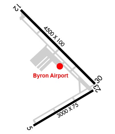
| Rwy | Rwy | |||||||
| 3000x75 | 3000' | 3000x75 | 3000' | |||||
| 4500x100 | 4500' | 4500x100 | 4500' | |||||
| Runway ID | Single Wheel | Double Wheel | Double Tandem Wheel | Dual Double Wheel |
| 05/23 | 29,500 | N/A | N/A | N/A |
| 12/30 | 29,500 | N/A | N/A | N/A |
| These numbers are Advisory and are not limits. The Airport Manager should have more accurate Weight Limits | ||||
 Airport Diagram might not be current. | |
| Facility Name: | BYRON |
| City Name: | BYRON |
| County: | CONTRA COSTA |
| State abbrev: | CA |
| State Name: | CALIFORNIA |
| Ownership: | PUBLICLY OWNED |
| Use: | OPEN TO THE PUBLIC |
| Owner's Name: | CONTRA COSTA COUNTY |
| Address: | 550 SALLY RIDE DR |
| CONCORD, CA 94520 | |
| Owner's Phone: | 844-359-8786 |
| Manager's Name: | KEITH FREITAS; MANAGER OF ARPTS CONTRA COSTA COUNTY. |
| Address: | 550 SALLY RIDE DR |
| CONCORD, CA 94250 | |
| Phone: | 844-359-8687 |
| FAA Region: | WESTERN-PACIFIC |
| FAA Field Office: | SFO |
| Date | Sunrise | Sunset |
|---|---|---|
| 09/24/21 Friday | 6:56 | 19:01 |
| 09/25/21 Saturday | 6:57 | 18:59 |
| 09/26/21 Sunday | 6:58 | 18:57 |
| 09/27/21 Monday | 6:58 | 18:56 |
| 09/28/21 Tuesday | 6:59 | 18:54 |
| 09/29/21 Wednesday | 7:00 | 18:53 |
| 09/30/21 Thursday | 7:01 | 18:51 |
| 10/01/21 Friday | 7:02 | 18:50 |
| 10/02/21 Saturday | 7:03 | 18:48 |
| 10/03/21 Sunday | 7:04 | 18:47 |
| 10/04/21 Monday | 7:05 | 18:45 |
| 10/05/21 Tuesday | 7:06 | 18:44 |
| 10/06/21 Wednesday | 7:06 | 18:42 |
| 10/07/21 Thursday | 7:07 | 18:41 |
| Airport Attendance Schedule | 7 Days A Week 0700-1400 |
| Airport Status | OPERATIONAL (This Status can change at any time - please check NOTAMS) |
| Airport Lighting Schedule | ACTVT REIL RWY 30; MIRL RWY 12/30 & 05/23 - CTAF. |
| Airport Storage Available | NONE |
| Extra Services Available | NONE |
| Wind Indicator | NONE |
| Control Tower | NO |
| CTAF Frequency | 123.050 |
| Unicom Frequency | 123.050 |
| Rotating Beacon Color | CLEAR-GREEN (Light Land Airport) |
| Segmented Circle | YES |
| Landing Fee |
| Airport Inspected | STATE - performed by STATE AERONAUTICAL PERSONNEL |
| Inspection Date | 09/10/2019 |
| Type of Fuel Available | Grade 100LL; -10FUEL AVBL 24 HRS BY CREDIT CARD. |
| Airframe Repair Service | None |
| Power Plant Repair Service | None |
| Latitude | N3749.7 |
| Longitude | W12137.6 (ESTIMATED) |
| Arpt Elevation | 78ft (SURVEYED) |
| Magnetic Variation | 15E |
| 2 miles S | of BYRON |
| Traffic Pattern Altitude | |
| Sectional Chart | SAN FRANCISCO |
| Operations (Reported) | Yearly | Avg. Daily |
|---|---|---|
| General Aviation Transient | 18000 | 49 |
| General Aviation Local | 65000 | 178 |
| Air Taxi | 0 | 0 |
| Commerical | 0 | 0 |
| Commuter | 0 | 0 |
| Military | 75 | 0 |
| Aircraft based on Field | |
|---|---|
| General Aviation Singles | 65 |
| General Aviation Multi | 0 |
| Jet Aircraft | 9 |
| General Aviation Helicopters | 0 |
| Military Aircraft | 0 |
| Gliders | 12 |
| Ultralights | 1 |
| FSS on field | NO |
| FSS tie-in | OAKLAND |
| FSS Phone | 1-800-WX-BRIEF |
| Who issues Notams | OAK |
| Notam D service at airport | YES |
| ARTCC Name | OAKLAND |
| Airport Certification | |
| Aircraft Rescue & Firefighting Index | None |
| Airport of Entry | No |
| Custom Landing Rights | No |
| Joint Civil/Military | No |
| Military Landing rights | No |
| NATIONAL PLAN OF INTEGRATED AIRPORT SYSTEMS (NPIAS) |
| GRANT AGREEMENTS UNDER FAAP/ADAP/AIP |
| ASSURANCES PURSUANT TO TITLE VI, CIVIL RIGHTS ACT OF 1964 |
| THIS AIRPORT HAS BEEN SURVEYED BY THE NATIONAL GEODETIC SURVEY. |
| ULTRALIGHT & SAILPLANE ACTIVITY ON & INVOF ARPT. |
| RISING TERRAIN WITH NUMEROUS WINDMILLS ON RIDGES WEST OF ARPT. |
| HANGAR APRON & TIEDOWN APRON 12500 LBS MAX. |
| RY 30 CALM WIND RY. |
| 200' TOWER 5600 FEET FROM RUNWAY 05. |
| 100' TOWER 5100 FEET FROM RUNWAY 23. |
| POWER PLANT 2.7 MILES SE OF AIRPORT PRODUCING THERMAL PLUMES; AVOID OVERLFIGHT BELOW 1,500 FT AGL. |
| FOR CD CTC NORCAL APCH AT 916-361-0516. |
Airport Communications & Frequencies:
| ||||||||||||||
| Runway: 05 | Runway: 23 | ||
| Mag heading: | 48° | Mag heading: | 228° |
| Rwy Slope: | -1.00% Down | Rwy Slope: | 1.00% Up |
| Approach: | Approach: | ||
| Pattern: | Right Traffic | Pattern: | Left Traffic |
| Markings: | BASIC | Markings: | BASIC |
| Marking Condition: | GOOD | Marking Condition: | GOOD |
| Arresting Dev: | Arresting Dev: | ||
| Lat & Long: | N3749.3 W12137.8 | Lat. & Long.: | N3749.6 W12137.3 |
| Elev: | 78.5 ft. MSL | Elev: | 48.6 ft. MSL |
| TCH: | TCH: | 25 ft. AGL | |
| Visual Glide Path: | Visual Glide Path: | 3.50 degrees | |
| Displaced Threshold: | No | Displaced Threshold: | No |
| Touchdown Zone: | YES | Touchdown Zone: | YES |
| Touchdown Elev.: | 78.5 feet | Touchdown Elev.: | 78.5 feet |
| Visual Glide Slope: | Visual Glide Slope: | 2-Light PAPI on LEFT side of Runway | |
| RVR Equipment: | RVR Equipment: | ||
| RVV Equipment: | NO | RVV Equipment: | NO |
| Approach Lights: | Approach Lights: | ||
| REIL: | NO | REIL: | NO |
| Centerline Lights: | NO | Centerline Lights: | NO |
| Touchdown lights: | NO | Touchdown lights: | NO |
| Runway Category: | Runway with a Visual Approach | Runway Category: | Runway with a Visual Approach |
| Declared Distances: | Declared Distances: | ||
| Obstructions: | WIND TURBINES | Obstructions: | |
| Marked: | NOT Marked/Lighted | Marked: | |
| Clearance slope: | 20:1 | Clearance slope: | 50:1 |
| Obstruction height: | 180 feet AGL | Obstruction height: | |
| Dist. from runway: | 3800 feet | Dist. from runway: | |
| Centerline offset: | 300 right of centerline | Centerline offset: | |
| Comments: | Comments: |
| Runway: 12 | Runway: 30 | ||
| Mag heading: | 120° | Mag heading: | 300° |
| Rwy Slope: | -.35% Down | Rwy Slope: | .35% Up |
| Approach: | Approach: | ||
| Pattern: | Left Traffic | Pattern: | Right Traffic |
| Markings: | NONPRECISION INSTRUMENT | Markings: | NONPRECISION INSTRUMENT |
| Marking Condition: | GOOD | Marking Condition: | GOOD |
| Arresting Dev: | Arresting Dev: | ||
| Lat & Long: | N3750.1 W12137.9 | Lat. & Long.: | N3749.6 W12137.2 |
| Elev: | 64.1 ft. MSL | Elev: | 48.4 ft. MSL |
| TCH: | TCH: | 25 ft. AGL | |
| Visual Glide Path: | Visual Glide Path: | 3.50 degrees | |
| Displaced Threshold: | No | Displaced Threshold: | No |
| Touchdown Zone: | YES | Touchdown Zone: | YES |
| Touchdown Elev.: | 64.1 feet | Touchdown Elev.: | 54.8 feet |
| Visual Glide Slope: | Visual Glide Slope: | 2-Light PAPI on LEFT side of Runway | |
| RVR Equipment: | RVR Equipment: | ||
| RVV Equipment: | NO | RVV Equipment: | NO |
| Approach Lights: | Approach Lights: | ||
| REIL: | NO | REIL: | YES |
| Centerline Lights: | NO | Centerline Lights: | NO |
| Touchdown lights: | NO | Touchdown lights: | NO |
| Runway Category: | Runway with a Visual Approach | Runway Category: | Runway with a Non-precision Approach having visibility minimums greater than 3/4 mile |
| Declared Distances: | Declared Distances: | ||
| Obstructions: | POLE | Obstructions: | HILL |
| Marked: | NOT Marked/Lighted | Marked: | NOT Marked/Lighted |
| Clearance slope: | 22:1 | Clearance slope: | 46:1 |
| Obstruction height: | 61 feet AGL | Obstruction height: | 65 feet AGL |
| Dist. from runway: | 1591 feet | Dist. from runway: | 3218 feet |
| Centerline offset: | 261 right of centerline | Centerline offset: | 729 feet left of centerline |
| Comments: | Comments: |
Thanks for using FltPlan.com
all rights reserved © 1999-2021 by Flight Plan LLC