
| NEW COALINGA MUNI COALINGA CA |
| |
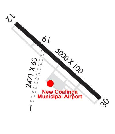
| Lat: N 3609.7 Long: W 12017.7 Elev: 625 Var: -15 Longest Runway: 5000 | ||
| AWOS: 119.27 CTAF: 122.7 | ||
| |||||||||||||||||||||||||||||||||||||||||||||||||||||||||||||
| |||||||||||||||||||||||||||||||||||||||||||||||||||||||||||||
| |||||||||||||||||||||||||||||||||||||||||||||||||||||||||||||
| Rwy | Rwy | |||||||
| 2471x60 | 2471' | 2471x60 | 2471' | |||||
| 5000x100 | 5000' | 5000x100 | 5000' | |||||
| Runway ID | Single Wheel | Double Wheel | Double Tandem Wheel | Dual Double Wheel |
| 01/19 | 12,500 | N/A | N/A | N/A |
| 12/30 | 30,000 | N/A | N/A | N/A |
| H1 | N/A | N/A | N/A | N/A |
| These numbers are Advisory and are not limits. The Airport Manager should have more accurate Weight Limits | ||||
| FltPlan does not have IFR approach charts available for KC80. |
 Airport Diagram might not be current. | |
| Facility Name: | NEW COALINGA MUNI |
| City Name: | COALINGA |
| County: | FRESNO |
| State abbrev: | CA |
| State Name: | CALIFORNIA |
| Ownership: | PUBLICLY OWNED |
| Use: | OPEN TO THE PUBLIC |
| Owner's Name: | CITY OF COALINGA |
| Address: | CITY HALL 155 W DURIAN |
| COALINGA, CA 93210 | |
| Owner's Phone: | 559-935-1533 |
| Manager's Name: | MERCEDES GARCIA |
| Address: | THE CITY OF COALINGA, 155 W DURIAN |
| COALINGA, CA 93210-1911 | |
| Phone: | 559-935-1533 |
| FAA Region: | WESTERN-PACIFIC |
| FAA Field Office: | SFO |
| Date | Sunrise | Sunset |
|---|---|---|
| 09/24/21 Friday | 6:51 | 18:55 |
| 09/25/21 Saturday | 6:51 | 18:54 |
| 09/26/21 Sunday | 6:52 | 18:52 |
| 09/27/21 Monday | 6:53 | 18:51 |
| 09/28/21 Tuesday | 6:54 | 18:49 |
| 09/29/21 Wednesday | 6:55 | 18:48 |
| 09/30/21 Thursday | 6:55 | 18:46 |
| 10/01/21 Friday | 6:56 | 18:45 |
| 10/02/21 Saturday | 6:57 | 18:44 |
| 10/03/21 Sunday | 6:58 | 18:42 |
| 10/04/21 Monday | 6:59 | 18:41 |
| 10/05/21 Tuesday | 6:59 | 18:39 |
| 10/06/21 Wednesday | 7:00 | 18:38 |
| 10/07/21 Thursday | 7:01 | 18:36 |
| Airport Attendance Schedule | IRREGULAR |
| Airport Status | OPERATIONAL (This Status can change at any time - please check NOTAMS) |
| Airport Lighting Schedule | REIL RWYS 12 & 30; MIRL RWY 12/30; PERIMETER LGTS H1 ON DUSK-0000; AFTER 0000 ACTVT - CTAF. PAPI RWYS 12 & 30 OPR CONSLY.; DUSK-DAWN. |
| Airport Storage Available | Tie Downs |
| Extra Services Available | NONE |
| Wind Indicator | YES - (lighted) |
| Control Tower | NO |
| CTAF Frequency | 122.700 |
| Unicom Frequency | 122.700 |
| Rotating Beacon Color | CLEAR-GREEN (Light Land Airport) |
| Segmented Circle | YES |
| Landing Fee | NO |
| Airport Inspected | STATE - performed by STATE AERONAUTICAL PERSONNEL |
| Inspection Date | 01/23/2020 |
| Type of Fuel Available | Grade 100LL |
| Airframe Repair Service | None |
| Power Plant Repair Service | None |
| Latitude | N3609.7 |
| Longitude | W12017.7 (ESTIMATED) |
| Arpt Elevation | 624ft (ESTIMATED) |
| Magnetic Variation | 15E |
| 3 miles E | of COALINGA |
| Traffic Pattern Altitude | |
| Sectional Chart | SAN FRANCISCO |
| Operations (Reported) | Yearly | Avg. Daily |
|---|---|---|
| General Aviation Transient | 2400 | 7 |
| General Aviation Local | 0 | 0 |
| Air Taxi | 0 | 0 |
| Commerical | 0 | 0 |
| Commuter | 0 | 0 |
| Military | 0 | 0 |
| Aircraft based on Field | |
|---|---|
| General Aviation Singles | 5 |
| General Aviation Multi | 0 |
| Jet Aircraft | 0 |
| General Aviation Helicopters | 0 |
| Military Aircraft | 0 |
| Gliders | 0 |
| Ultralights | 0 |
| FSS on field | NO |
| FSS tie-in | RANCHO MURIETA |
| FSS Phone | 1-800-WX-BRIEF |
| Who issues Notams | RIU |
| Notam D service at airport | YES |
| ARTCC Name | OAKLAND |
| Airport Certification | |
| Aircraft Rescue & Firefighting Index | None |
| Airport of Entry | No |
| Custom Landing Rights | No |
| Joint Civil/Military | No |
| Military Landing rights | No |
| NATIONAL PLAN OF INTEGRATED AIRPORT SYSTEMS (NPIAS) |
| GRANT AGREEMENTS UNDER FAAP/ADAP/AIP |
| ASSURANCES PURSUANT TO TITLE VI, CIVIL RIGHTS ACT OF 1964 |
| RY 01/19 AVBL FOR DAYTIME USE ONLY. |
| FOR CD CTC OAKLAND ARTCC AT 510-745-3380. |
| RWY 01/1 9 RWY 01/19 IS IN POOR COND; ASPH-GRVL CRACKED IN PLACES WITH SMALL POTHOLES, ROCKS AND LOOSE GRAVEL. RWY SFC MARKINGS ARE FADED. |
| RWY 01/1 9 1OIL TREATED. |
| RWY 01/1 9 RY 01/19 RESTRICTED BY AIRPORT MGT TO ACFT UNDER 6,000 LBS SINGLE WHEEL. |
| Runway: 01 | Runway: 19 | ||
| Mag heading: | 357° | Mag heading: | 176° |
| Rwy Slope: | .04% Up | Rwy Slope: | -.04% Down |
| Approach: | Approach: | ||
| Pattern: | Left Traffic | Pattern: | Right Traffic |
| Markings: | BASIC | Markings: | BASIC |
| Marking Condition: | POOR | Marking Condition: | POOR |
| Arresting Dev: | Arresting Dev: | ||
| Lat & Long: | N3609.4 W12017.9 | Lat. & Long.: | N3609.8 W12017.8 |
| Elev: | 606.9 ft. MSL | Elev: | 608.0 ft. MSL |
| TCH: | TCH: | ||
| Visual Glide Path: | Visual Glide Path: | ||
| Displaced Threshold: | No | Displaced Threshold: | No |
| Touchdown Zone: | YES | Touchdown Zone: | YES |
| Touchdown Elev.: | 608.0 feet | Touchdown Elev.: | 608.0 feet |
| Visual Glide Slope: | Visual Glide Slope: | ||
| RVR Equipment: | RVR Equipment: | ||
| RVV Equipment: | NO | RVV Equipment: | NO |
| Approach Lights: | Approach Lights: | ||
| REIL: | NO | REIL: | NO |
| Centerline Lights: | NO | Centerline Lights: | NO |
| Touchdown lights: | NO | Touchdown lights: | NO |
| Runway Category: | Runway with a Visual Approach | Runway Category: | Runway with a Visual Approach |
| Declared Distances: | Declared Distances: |
| Runway: 12 | Runway: 30 | ||
| Mag heading: | 115° | Mag heading: | 295° |
| Rwy Slope: | -.46% Down | Rwy Slope: | .46% Up |
| Approach: | Approach: | ||
| Pattern: | Left Traffic | Pattern: | Right Traffic |
| Markings: | NONPRECISION INSTRUMENT | Markings: | NONPRECISION INSTRUMENT |
| Marking Condition: | FAIR | Marking Condition: | FAIR |
| Arresting Dev: | Arresting Dev: | ||
| Lat & Long: | N3610.1 W12018.0 | Lat. & Long.: | N3609.5 W12017.2 |
| Elev: | 624.8 ft. MSL | Elev: | 601.8 ft. MSL |
| TCH: | 40 ft. AGL | TCH: | 40 ft. AGL |
| Visual Glide Path: | 3.00 degrees | Visual Glide Path: | 3.00 degrees |
| Displaced Threshold: | No | Displaced Threshold: | No |
| Touchdown Zone: | YES | Touchdown Zone: | YES |
| Touchdown Elev.: | 624.8 feet | Touchdown Elev.: | 609.9 feet |
| Visual Glide Slope: | 2-Light PAPI on LEFT side of Runway | Visual Glide Slope: | 2-Light PAPI on LEFT side of Runway |
| RVR Equipment: | RVR Equipment: | ||
| RVV Equipment: | NO | RVV Equipment: | NO |
| Approach Lights: | Approach Lights: | ||
| REIL: | YES | REIL: | YES |
| Centerline Lights: | NO | Centerline Lights: | NO |
| Touchdown lights: | NO | Touchdown lights: | NO |
| Runway Category: | Runway with a Visual Approach | Runway Category: | Runway with a Visual Approach |
| Declared Distances: | Declared Distances: |
Thanks for using FltPlan.com
all rights reserved © 1999-2021 by Flight Plan LLC

