
| POPLAR GROVE POPLAR GROVE IL |
| |
| Lat: N 4219.4 Long: W 08850.2 Elev: 857 Var: -01 Longest Runway: 3773 | ||
| CTAF: 122.8 | ||
| |||||||||||||||||||||||||||||||||||||||||||||||||||||||||||||
| |||||||||||||||||||||||||||||||||||||||||||||||||||||||||||||
| Rwy | Rwy | |||||||
| 2709x200 | 2709' | 2709x200 | 2709' | |||||
| 3773x50 | 3273' | 3773x50 | 3773' | |||||
| 2467x150 | 2247' | 2467x150 | 2467' | |||||
| Runway ID | Single Wheel | Double Wheel | Double Tandem Wheel | Dual Double Wheel |
| 09/27 | N/A | N/A | N/A | N/A |
| 12/30 | N/A | N/A | N/A | N/A |
| 17/35 | N/A | N/A | N/A | N/A |
| These numbers are Advisory and are not limits. The Airport Manager should have more accurate Weight Limits | ||||
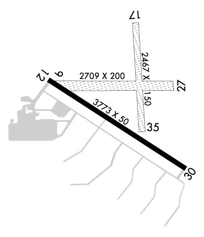 Airport Diagram might not be current. | |
| Facility Name: | POPLAR GROVE |
| City Name: | POPLAR GROVE |
| County: | BOONE |
| State abbrev: | IL |
| State Name: | ILLINOIS |
| Ownership: | PRIVATELY OWNED |
| Use: | OPEN TO THE PUBLIC |
| Owner's Name: | STEVE THOMAS; ALT BLAKE THOMAS |
| Address: | 11619 RTE 76 |
| POPLAR GROVE, IL 61065 | |
| Owner's Phone: | 815-544-3471 |
| Manager's Name: | STEVE R. THOMAS |
| Address: | 11619 RT 76; EMAIL ADDRESS: STEVE@POPLARGROVEAIRMOTIVE.COM (ALL LOWER CASE) |
| POPLAR GROVE, IL 61065 | |
| Phone: | 815-544-3471 |
| FAA Region: | GREAT LAKES |
| FAA Field Office: | CHI |

| Date | Sunrise | Sunset |
|---|---|---|
| 09/24/21 Friday | 6:45 | 18:49 |
| 09/25/21 Saturday | 6:46 | 18:48 |
| 09/26/21 Sunday | 6:47 | 18:46 |
| 09/27/21 Monday | 6:48 | 18:44 |
| 09/28/21 Tuesday | 6:49 | 18:42 |
| 09/29/21 Wednesday | 6:50 | 18:41 |
| 09/30/21 Thursday | 6:51 | 18:39 |
| 10/01/21 Friday | 6:52 | 18:37 |
| 10/02/21 Saturday | 6:53 | 18:35 |
| 10/03/21 Sunday | 6:54 | 18:34 |
| 10/04/21 Monday | 6:55 | 18:32 |
| 10/05/21 Tuesday | 6:57 | 18:30 |
| 10/06/21 Wednesday | 6:58 | 18:29 |
| 10/07/21 Thursday | 6:59 | 18:27 |
| Airport Attendance Schedule | 7 Days A Week SR-SS |
| Airport Status | OPERATIONAL (This Status can change at any time - please check NOTAMS) |
| Airport Lighting Schedule | SS-SR |
| Airport Storage Available | Tie Downs, Hanger |
| Extra Services Available | Air Freight, Avionics, Cargo Handling, Charter, Flight Instruction, Aircraft Rental, Aircraft Sales |
| Wind Indicator | YES - (lighted) |
| Control Tower | NO |
| CTAF Frequency | 122.800 |
| Unicom Frequency | 122.800 |
| Rotating Beacon Color | CLEAR-GREEN (Light Land Airport) |
| Segmented Circle | NO |
| Landing Fee | NO |
| Airport Inspected | STATE - performed by STATE AERONAUTICAL PERSONNEL |
| Inspection Date | 06/25/2020 |
| Type of Fuel Available | Grade 100LL |
| Airframe Repair Service | MAJOR |
| Power Plant Repair Service | MAJOR |
| Latitude | N4219.4 |
| Longitude | W08850.2 (ESTIMATED) |
| Arpt Elevation | 857ft (SURVEYED) |
| Magnetic Variation | 01E |
| 3 miles S | of POPLAR GROVE |
| Traffic Pattern Altitude | |
| Sectional Chart | CHICAGO |
| Operations (Reported) | Yearly | Avg. Daily |
|---|---|---|
| General Aviation Transient | 18000 | 49 |
| General Aviation Local | 48000 | 132 |
| Air Taxi | 0 | 0 |
| Commerical | 0 | 0 |
| Commuter | 0 | 0 |
| Military | 0 | 0 |
| Aircraft based on Field | |
|---|---|
| General Aviation Singles | 0 |
| General Aviation Multi | 0 |
| Jet Aircraft | 0 |
| General Aviation Helicopters | 0 |
| Military Aircraft | 0 |
| Gliders | 0 |
| Ultralights | 0 |
| FSS on field | NO |
| FSS tie-in | KANKAKEE |
| FSS Phone | 1-800-WX-BRIEF |
| Who issues Notams | IKK |
| Notam D service at airport | YES |
| ARTCC Name | CHICAGO |
| Airport Certification | |
| Aircraft Rescue & Firefighting Index | None |
| Airport of Entry | No |
| Custom Landing Rights | No |
| Joint Civil/Military | No |
| Military Landing rights | No |
| NATIONAL PLAN OF INTEGRATED AIRPORT SYSTEMS (NPIAS) |
| THIS AIRPORT HAS BEEN SURVEYED BY THE NATIONAL GEODETIC SURVEY. |
| CAUTION: IMPAIRED SIGHT CLNCS BTN RWY ENDS DUE TO ROLLING TRRN. |
| FOR CD CTC CHICAGO ARTCC AT 630-906-8921. |
| RWY 09/2 7 CLSD WHEN SNOW COVERED EXCP TO SKI ACFT. |
| RWY 17/3 5 CLSD WHEN SNOW COVERED EXCP TO SKI ACFT. |
| RWY 30 CALM WIND RWY. |
| RWY 12/3 0 NSTD LIRL DUE TO SPACING, INTST & NON-FRANGIBLE MOUNTINGS. |
Airport Communications & Frequencies:
| ||||||||||||||
| Runway: 09 | Runway: 27 | ||
| Mag heading: | 89° | Mag heading: | 269° |
| Rwy Slope: | -.31% Down | Rwy Slope: | .31% Up |
| Approach: | Approach: | ||
| Pattern: | Left Traffic | Pattern: | Left Traffic |
| Markings: | Markings: | ||
| Marking Condition: | Marking Condition: | ||
| Arresting Dev: | Arresting Dev: | ||
| Lat & Long: | N4219.4 W08850.5 | Lat. & Long.: | N4219.4 W08849.9 |
| Elev: | 857.4 ft. MSL | Elev: | 849.0 ft. MSL |
| TCH: | TCH: | ||
| Visual Glide Path: | Visual Glide Path: | ||
| Displaced Threshold: | No | Displaced Threshold: | No |
| Touchdown Zone: | NO | Touchdown Zone: | NO |
| Touchdown Elev.: | Touchdown Elev.: | ||
| Visual Glide Slope: | Visual Glide Slope: | ||
| RVR Equipment: | RVR Equipment: | ||
| RVV Equipment: | NO | RVV Equipment: | NO |
| Approach Lights: | Approach Lights: | ||
| REIL: | NO | REIL: | NO |
| Centerline Lights: | NO | Centerline Lights: | NO |
| Touchdown lights: | NO | Touchdown lights: | NO |
| Runway Category: | Runway with a Visual Approach | Runway Category: | Runway with a Visual Approach |
| Declared Distances: | Declared Distances: | ||
| Obstructions: | Obstructions: | TREE | |
| Marked: | Marked: | NOT Marked/Lighted | |
| Clearance slope: | 20:1 | Clearance slope: | 10:1 |
| Obstruction height: | Obstruction height: | 60 feet AGL | |
| Dist. from runway: | Dist. from runway: | 655 feet | |
| Centerline offset: | Centerline offset: | 155 feet right of centerline | |
| Comments: | Comments: |
| Runway: 12 | Runway: 30 | ||
| Mag heading: | 122° | Mag heading: | 302° |
| Rwy Slope: | -.14% Down | Rwy Slope: | .14% Up |
| Approach: | Approach: | ||
| Pattern: | Left Traffic | Pattern: | Left Traffic |
| Markings: | BASIC | Markings: | BASIC |
| Marking Condition: | GOOD | Marking Condition: | GOOD |
| Arresting Dev: | Arresting Dev: | ||
| Lat & Long: | N4219.4 W08850.6 | Lat. & Long.: | N4219.1 W08849.9 |
| Elev: | 855.5 ft. MSL | Elev: | 850.2 ft. MSL |
| TCH: | TCH: | ||
| Visual Glide Path: | Visual Glide Path: | ||
| Displaced Threshold: | 500 feet; MKD WITH WHITE BARS UNDER NUMBERS; NO ARROWS. | Displaced Threshold: | No |
| Touchdown Zone: | YES | Touchdown Zone: | NO |
| Touchdown Elev.: | 856.0 feet | Touchdown Elev.: | |
| Visual Glide Slope: | Visual Glide Slope: | ||
| RVR Equipment: | RVR Equipment: | ||
| RVV Equipment: | NO | RVV Equipment: | NO |
| Approach Lights: | Approach Lights: | ||
| REIL: | NO | REIL: | NO |
| Centerline Lights: | NO | Centerline Lights: | NO |
| Touchdown lights: | NO | Touchdown lights: | NO |
| Runway Category: | Runway with a Visual Approach | Runway Category: | Runway with a Visual Approach |
| Declared Distances: | Declared Distances: |
| Runway: 17 | Runway: 35 | ||
| Mag heading: | 175° | Mag heading: | 355° |
| Rwy Slope: | -.05% Down | Rwy Slope: | .05% Up |
| Approach: | Approach: | ||
| Pattern: | Left Traffic | Pattern: | Left Traffic |
| Markings: | Markings: | ||
| Marking Condition: | Marking Condition: | ||
| Arresting Dev: | Arresting Dev: | ||
| Lat & Long: | N4219.7 W08850.1 | Lat. & Long.: | N4219.3 W08850.1 |
| Elev: | 850.0 ft. MSL | Elev: | 848.7 ft. MSL |
| TCH: | TCH: | ||
| Visual Glide Path: | Visual Glide Path: | ||
| Displaced Threshold: | 220 feet; MKD WITH THREE CONES ON EACH SIDE OF RWY. | Displaced Threshold: | No |
| Touchdown Zone: | NO | Touchdown Zone: | NO |
| Touchdown Elev.: | Touchdown Elev.: | ||
| Visual Glide Slope: | Visual Glide Slope: | ||
| RVR Equipment: | RVR Equipment: | ||
| RVV Equipment: | NO | RVV Equipment: | NO |
| Approach Lights: | Approach Lights: | ||
| REIL: | NO | REIL: | NO |
| Centerline Lights: | NO | Centerline Lights: | NO |
| Touchdown lights: | NO | Touchdown lights: | NO |
| Runway Category: | Runway with a Visual Approach | Runway Category: | Runway with a Visual Approach |
| Declared Distances: | Declared Distances: | ||
| Obstructions: | ROAD | Obstructions: | |
| Marked: | NOT Marked/Lighted | Marked: | |
| Clearance slope: | APCH SLOPE IS 20:1 AT DSPLCD THR. | Clearance slope: | 20:1 |
| Obstruction height: | 17 feet AGL | Obstruction height: | |
| Dist. from runway: | 0 feet | Dist. from runway: | |
| Centerline offset: | Centerline offset: | ||
| Comments: | Comments: |
Thanks for using FltPlan.com
all rights reserved © 1999-2021 by Flight Plan LLC
