
| MARSHALL COUNTY LACON IL |
| |
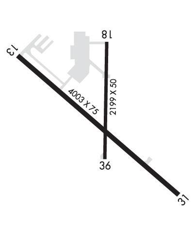
| Lat: N 4101.1 Long: W 08923.1 Elev: 585 Var: +01 Longest Runway: 4003 | ||
| AWOS: 119.42 CTAF: 122.8 | ||
| ||||||||||||||||||||||||||||||||||||||||||||
| ||||||||||||||||||||||||||||||||||||||||||||
| ||||||||||||||||||||||||||||||||||||||||||||
| Rwy | Rwy | |||||||
| 4003x75 | 4003' | 4003x75 | 4003' | |||||
| 2199x50 | 2199' | 2199x50 | 2199' | |||||
| Runway ID | Single Wheel | Double Wheel | Double Tandem Wheel | Dual Double Wheel |
| 13/31 | N/A | N/A | N/A | N/A |
| 18/36 | 4,000 | N/A | N/A | N/A |
| These numbers are Advisory and are not limits. The Airport Manager should have more accurate Weight Limits | ||||
 Airport Diagram might not be current. | |
| Facility Name: | MARSHALL COUNTY |
| City Name: | LACON |
| County: | MARSHALL |
| State abbrev: | IL |
| State Name: | ILLINOIS |
| Ownership: | PUBLICLY OWNED |
| Use: | OPEN TO THE PUBLIC |
| Owner's Name: | MARSHALL COUNTY |
| Address: | 122 N PRAIRIE ST |
| LACON, IL 61540 | |
| Owner's Phone: | 309-246-3667 |
| Manager's Name: | JOE TROGLIO |
| Address: | 1315 IL-17, PO BOX 38 |
| LACON, IL 61540 | |
| Phone: | 309-246-2870; CELL PHONE: 309-863-5216 |
| FAA Region: | GREAT LAKES |
| FAA Field Office: | CHI |
| Date | Sunrise | Sunset |
|---|---|---|
| 06/08/26 Monday | 5:25 | 20:28 |
| 06/09/26 Tuesday | 5:25 | 20:29 |
| 06/10/26 Wednesday | 5:25 | 20:29 |
| 06/11/26 Thursday | 5:25 | 20:30 |
| 06/12/26 Friday | 5:25 | 20:30 |
| 06/13/26 Saturday | 5:25 | 20:31 |
| 06/14/26 Sunday | 5:25 | 20:31 |
| 06/15/26 Monday | 5:25 | 20:31 |
| 06/16/26 Tuesday | 5:25 | 20:32 |
| 06/17/26 Wednesday | 5:25 | 20:32 |
| 06/18/26 Thursday | 5:25 | 20:32 |
| 06/19/26 Friday | 5:25 | 20:33 |
| 06/20/26 Saturday | 5:25 | 20:33 |
| 06/21/26 Sunday | 5:25 | 20:33 |
| Airport Attendance Schedule | 7 Days A Week 0800-1700 |
| Airport Status | OPERATIONAL (This Status can change at any time - please check NOTAMS) |
| Airport Lighting Schedule | ACTVT MIRL RY 13/31; REIL RY 13 & PAPI RY 31 - CTAF. |
| Airport Storage Available | Tie Downs, Hanger |
| Extra Services Available | Avionics |
| Wind Indicator | YES - (lighted) |
| Control Tower | NO |
| CTAF Frequency | 122.800 |
| Unicom Frequency | 122.800 |
| Rotating Beacon Color | WG |
| Segmented Circle | YES |
| Landing Fee | NO |
| Airport Inspected | STATE - performed by STATE AERONAUTICAL PERSONNEL |
| Inspection Date | 05/07/2025 |
| Type of Fuel Available | Grade 100LLUL94; -10100LL & UL94 AVBL 24HR SELF SVC VIA CREDIT CARD. |
| Airframe Repair Service | MAJOR |
| Power Plant Repair Service | MAJOR |
| Latitude | N4101.1 |
| Longitude | W08923.1 (ESTIMATED) |
| Arpt Elevation | 584ft (SURVEYED) |
| Magnetic Variation | 01W |
| 1 miles E | of LACON |
| Traffic Pattern Altitude | |
| Sectional Chart | CHICAGO |
| Operations (Reported) | Yearly | Avg. Daily |
|---|---|---|
| General Aviation Transient | 0 | 0 |
| General Aviation Local | 0 | 0 |
| Air Taxi | 0 | 0 |
| Commerical | 0 | 0 |
| Commuter | 0 | 0 |
| Military | 0 | 0 |
| Aircraft based on Field | |
|---|---|
| General Aviation Singles | 0 |
| General Aviation Multi | 0 |
| Jet Aircraft | 0 |
| General Aviation Helicopters | 0 |
| Military Aircraft | 0 |
| Gliders | 0 |
| Ultralights | 0 |
| FSS on field | NO |
| FSS tie-in | KANKAKEE |
| FSS Phone | 1-800-WX-BRIEF |
| Who issues Notams | C75 |
| Notam D service at airport | YES |
| ARTCC Name | CHICAGO |
| Airport Certification | |
| Aircraft Rescue & Firefighting Index | None |
| Airport of Entry | No |
| Custom Landing Rights | No |
| Joint Civil/Military | No |
| Military Landing rights | YES |
| NATIONAL PLAN OF INTEGRATED AIRPORT SYSTEMS (NPIAS) |
| GRANT AGREEMENTS UNDER FAAP/ADAP/AIP |
| ASSURANCES PURSUANT TO TITLE VI, CIVIL RIGHTS ACT OF 1964 |
| RY 31 DEPARTURES ENCOURAGED TO BEGIN RIGHT TURN AS SOON AS PRACTICAL FOR NOISE ABATEMENT |
| FOR CD CTC CHICAGO ARTCC AT 630-906-8921. |
| BIRDS AND ANIMALS ON AND INVOF ARPT. |
| RWY 31 R TFC & RWY 13 L TFC DUE TO NOISE ABATEMENT. |
Airport Communications & Frequencies:
| |||||||||
| Runway: 13 | Runway: 31 | ||
| Mag heading: | 129° | Mag heading: | 309° |
| Rwy Slope: | 1.15% Up | Rwy Slope: | -1.15% Down |
| Approach: | Approach: | ||
| Pattern: | Left Traffic | Pattern: | Right Traffic |
| Markings: | NONPRECISION INSTRUMENT | Markings: | NONPRECISION INSTRUMENT |
| Marking Condition: | FAIR | Marking Condition: | FAIR |
| Arresting Dev: | Arresting Dev: | ||
| Lat & Long: | N4101.3 W08923.5 | Lat. & Long.: | N4100.9 W08922.8 |
| Elev: | 538.5 ft. MSL | Elev: | 584.5 ft. MSL |
| TCH: | TCH: | 20 ft. AGL | |
| Visual Glide Path: | Visual Glide Path: | 4.00 degrees | |
| Displaced Threshold: | No | Displaced Threshold: | No |
| Touchdown Zone: | YES | Touchdown Zone: | YES |
| Touchdown Elev.: | 564.4 feet | Touchdown Elev.: | 584.5 feet |
| Visual Glide Slope: | Visual Glide Slope: | 4-Light PAPI on LEFT side of Runway | |
| RVR Equipment: | RVR Equipment: | ||
| RVV Equipment: | NO | RVV Equipment: | NO |
| Approach Lights: | Approach Lights: | ||
| REIL: | YES | REIL: | NO |
| Centerline Lights: | NO | Centerline Lights: | NO |
| Touchdown lights: | NO | Touchdown lights: | NO |
| Runway Category: | Runway with a Non-precision Approach | Runway Category: | Runway with a Visual Approach |
| Declared Distances: | Declared Distances: | ||
| Obstructions: | Obstructions: | GND | |
| Marked: | Marked: | NOT Marked/Lighted | |
| Clearance slope: | 20:1 | Clearance slope: | 20:1 |
| Obstruction height: | Obstruction height: | 56 feet AGL | |
| Dist. from runway: | Dist. from runway: | 1336 feet | |
| Centerline offset: | Centerline offset: | ||
| Comments: | Comments: |
| Runway: 18 | Runway: 36 | ||
| Mag heading: | 182° | Mag heading: | 2° |
| Rwy Slope: | -.30% Down | Rwy Slope: | .30% Up |
| Approach: | Approach: | ||
| Pattern: | Left Traffic | Pattern: | Left Traffic |
| Markings: | BASIC | Markings: | BASIC |
| Marking Condition: | GOOD | Marking Condition: | GOOD |
| Arresting Dev: | Arresting Dev: | ||
| Lat & Long: | N4101.4 W08923.1 | Lat. & Long.: | N4101.0 W08923.1 |
| Elev: | 554.2 ft. MSL | Elev: | 547.7 ft. MSL |
| TCH: | TCH: | ||
| Visual Glide Path: | Visual Glide Path: | ||
| Displaced Threshold: | No | Displaced Threshold: | No |
| Touchdown Zone: | YES | Touchdown Zone: | YES |
| Touchdown Elev.: | 554.9 feet | Touchdown Elev.: | 554.9 feet |
| Visual Glide Slope: | Visual Glide Slope: | ||
| RVR Equipment: | RVR Equipment: | ||
| RVV Equipment: | NO | RVV Equipment: | NO |
| Approach Lights: | Approach Lights: | ||
| REIL: | NO | REIL: | NO |
| Centerline Lights: | NO | Centerline Lights: | NO |
| Touchdown lights: | NO | Touchdown lights: | NO |
| Runway Category: | Runway with a Visual Approach | Runway Category: | Runway with a Visual Approach |
| Declared Distances: | Declared Distances: | ||
| Obstructions: | ROAD | Obstructions: | |
| Marked: | NOT Marked/Lighted | Marked: | |
| Clearance slope: | 14:1 | Clearance slope: | 20:1 |
| Obstruction height: | 9 feet AGL | Obstruction height: | |
| Dist. from runway: | 334 feet | Dist. from runway: | |
| Centerline offset: | Centerline offset: | ||
| Comments: | Comments: |
Thanks for using FltPlan.com
all rights reserved © 1999-2026 by Flight Plan LLC
