
| KENDALLVILLE BOAC KENDALLVILLE IN |
| |
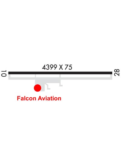
| Lat: N 4128.4 Long: W 08515.6 Elev: 1004 Var: +04 Longest Runway: 4400 | ||
| AWOS: 119.92 CTAF: 122.8 | ||
| |||||||||||||||||||||||
| |||||||||||||||||||||||
| |||||||||||||||||||||||
| Rwy | Rwy | |||||||
| 4400x75 | 4400' | 4400x75 | 4400' | |||||
| Runway ID | Single Wheel | Double Wheel | Double Tandem Wheel | Dual Double Wheel |
| 10/28 | 12,500 | N/A | N/A | N/A |
| These numbers are Advisory and are not limits. The Airport Manager should have more accurate Weight Limits | ||||
 Airport Diagram might not be current. | |
| Facility Name: | KENDALLVILLE MUNI |
| City Name: | KENDALLVILLE |
| County: | NOBLE |
| State abbrev: | IN |
| State Name: | INDIANA |
| Ownership: | PUBLICLY OWNED |
| Use: | OPEN TO THE PUBLIC |
| Owner's Name: | KENDALLVILLE BOAC |
| Address: | 363 E AIRPORT RD |
| KENDALLVILLE, IN 46755 | |
| Owner's Phone: | 260-349-0350 |
| Manager's Name: | JOHN KLINE |
| Address: | 363 E. AIRPORT RD. |
| KENDALLVILLE, IN 46755 | |
| Phone: | 260-349-0350 |
| FAA Region: | GREAT LAKES |
| FAA Field Office: | CHI |
| Date | Sunrise | Sunset |
|---|---|---|
| 06/08/26 Monday | 6:07 | 21:13 |
| 06/09/26 Tuesday | 6:07 | 21:14 |
| 06/10/26 Wednesday | 6:07 | 21:14 |
| 06/11/26 Thursday | 6:07 | 21:15 |
| 06/12/26 Friday | 6:07 | 21:15 |
| 06/13/26 Saturday | 6:07 | 21:16 |
| 06/14/26 Sunday | 6:07 | 21:16 |
| 06/15/26 Monday | 6:07 | 21:16 |
| 06/16/26 Tuesday | 6:07 | 21:17 |
| 06/17/26 Wednesday | 6:07 | 21:17 |
| 06/18/26 Thursday | 6:07 | 21:17 |
| 06/19/26 Friday | 6:07 | 21:18 |
| 06/20/26 Saturday | 6:07 | 21:18 |
| 06/21/26 Sunday | 6:07 | 21:18 |
| Airport Attendance Schedule | SUN 1200-1700, MON - SAT 0800-1700; EMERG - 574-276-3933. |
| Airport Status | OPERATIONAL (This Status can change at any time - please check NOTAMS) |
| Airport Lighting Schedule | ACTVT REIL RWY 10 & 28; PAPI RWY 10 & 28; MIRL RWY 10/28 - CTAF. |
| Airport Storage Available | Tie Downs, Hanger |
| Extra Services Available | Crop Dusting, Flight Instruction, Aircraft Rental, Glider Towing |
| Wind Indicator | YES - (lighted) |
| Control Tower | NO |
| CTAF Frequency | 122.800 |
| Unicom Frequency | 122.800 |
| Rotating Beacon Color | WG |
| Segmented Circle | YES |
| Landing Fee | NO |
| Airport Inspected | STATE - performed by STATE AERONAUTICAL PERSONNEL |
| Inspection Date | 10/31/2021 |
| Type of Fuel Available | Grade 100LL, JET A (freeze point -40C) |
| Airframe Repair Service | MINOR |
| Power Plant Repair Service | MINOR |
| Latitude | N4128.4 |
| Longitude | W08515.6 (ESTIMATED) |
| Arpt Elevation | 1004ft (SURVEYED) |
| Magnetic Variation | 04W |
| 2 miles N | of KENDALLVILLE |
| Traffic Pattern Altitude | |
| Sectional Chart | CHICAGO |
| Operations (Reported) | Yearly | Avg. Daily |
|---|---|---|
| General Aviation Transient | 0 | 0 |
| General Aviation Local | 0 | 0 |
| Air Taxi | 0 | 0 |
| Commerical | 0 | 0 |
| Commuter | 0 | 0 |
| Military | 0 | 0 |
| Aircraft based on Field | |
|---|---|
| General Aviation Singles | 0 |
| General Aviation Multi | 0 |
| Jet Aircraft | 0 |
| General Aviation Helicopters | 0 |
| Military Aircraft | 0 |
| Gliders | 0 |
| Ultralights | 0 |
| FSS on field | NO |
| FSS tie-in | TERRE HAUTE |
| FSS Phone | 1-800-WX-BRIEF |
| Who issues Notams | HUF |
| Notam D service at airport | YES |
| ARTCC Name | CHICAGO |
| Airport Certification | |
| Aircraft Rescue & Firefighting Index | None |
| Airport of Entry | No |
| Custom Landing Rights | No |
| Joint Civil/Military | No |
| Military Landing rights | YES |
| NATIONAL PLAN OF INTEGRATED AIRPORT SYSTEMS (NPIAS) |
| GRANT AGREEMENTS UNDER FAAP/ADAP/AIP |
| ASSURANCES PURSUANT TO TITLE VI, CIVIL RIGHTS ACT OF 1964 |
| GLIDER OPS MAY-NOV 0900-SS. |
| FOR CD CTC CHICAGO ARTCC AT 630-906-8921. |
| RWY 10/2 8 160 FT CROPS N OF CNTRLN ENTIRE LEN. |
| RWY 10 5 FT TRRN DOWN SLOPE 100 FT FM RWY END. |
Airport Communications & Frequencies:
| |||||||||||||||||||||||||||
| Runway: 10 | Runway: 28 | ||
| Mag heading: | 96° | Mag heading: | 276° |
| Rwy Slope: | .10% Up | Rwy Slope: | -.10% Down |
| Approach: | Approach: | ||
| Pattern: | Left Traffic | Pattern: | Left Traffic |
| Markings: | NONPRECISION INSTRUMENT | Markings: | NONPRECISION INSTRUMENT |
| Marking Condition: | GOOD | Marking Condition: | GOOD |
| Arresting Dev: | Arresting Dev: | ||
| Lat & Long: | N4128.4 W08516.1 | Lat. & Long.: | N4128.4 W08515.2 |
| Elev: | 999.7 ft. MSL | Elev: | 1004.2 ft. MSL |
| TCH: | 28 ft. AGL | TCH: | 31 ft. AGL |
| Visual Glide Path: | 3.50 degrees | Visual Glide Path: | 3.50 degrees |
| Displaced Threshold: | No | Displaced Threshold: | No |
| Touchdown Zone: | YES | Touchdown Zone: | YES |
| Touchdown Elev.: | 999.7 feet | Touchdown Elev.: | 1004.3 feet |
| Visual Glide Slope: | 2-Light PAPI on LEFT side of Runway | Visual Glide Slope: | 2-Light PAPI on LEFT side of Runway; UNUSBL BYD 9 DEGS RIGHT OF CNTRLN. |
| RVR Equipment: | RVR Equipment: | ||
| RVV Equipment: | NO | RVV Equipment: | NO |
| Approach Lights: | Approach Lights: | ||
| REIL: | YES | REIL: | YES |
| Centerline Lights: | NO | Centerline Lights: | NO |
| Touchdown lights: | NO | Touchdown lights: | NO |
| Runway Category: | Runway with a Non-precision Approach | Runway Category: | Runway with a Non-precision Approach |
| Declared Distances: | Declared Distances: | ||
| Obstructions: | TREES | Obstructions: | TREES |
| Marked: | NOT Marked/Lighted | Marked: | NOT Marked/Lighted |
| Clearance slope: | 18:1 | Clearance slope: | 19:1 |
| Obstruction height: | 40 feet AGL | Obstruction height: | 40 feet AGL |
| Dist. from runway: | 945 feet | Dist. from runway: | 990 feet |
| Centerline offset: | 250 left of centerline | Centerline offset: | 140 feet right of centerline |
| Comments: | Comments: |
Thanks for using FltPlan.com
all rights reserved © 1999-2026 by Flight Plan LLC

