
| LAKE LAWN DELAVAN WI |
| |
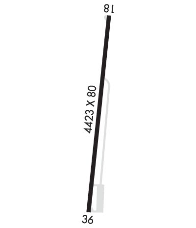
| Lat: N 4238.0 Long: W 08836.1 Elev: 981 Var: +02 Longest Runway: 4423 | ||
| CTAF: 122.9 | ||
| ||||||||||||||||||||||||||||||||
| ||||||||||||||||||||||||||||||||
| Rwy | Rwy | |||||||
| 4423x80 | 4103' | 4423x80 | 4123' | |||||
| Runway ID | Single Wheel | Double Wheel | Double Tandem Wheel | Dual Double Wheel |
| 18/36 | N/A | N/A | N/A | N/A |
| These numbers are Advisory and are not limits. The Airport Manager should have more accurate Weight Limits | ||||
| FltPlan does not have IFR approach charts available for KC59. |
 Airport Diagram might not be current. | |
| Facility Name: | LAKE LAWN |
| City Name: | DELAVAN |
| County: | WALWORTH |
| State abbrev: | WI |
| State Name: | WISCONSIN |
| Ownership: | PRIVATELY OWNED |
| Use: | OPEN TO THE PUBLIC |
| Owner's Name: | DELEVAN LAKE LAWN MANAGEMENT |
| Address: | 2400 EAST GENEVA ST |
| DELAVAN, WI 53115 | |
| Owner's Phone: | 262-728-7950 |
| Manager's Name: | DANIEL LYNG |
| Address: | 2400 EAST GENEVA ST |
| DELAVAN, WI 53115 | |
| Phone: | (262) 725-9127 |
| FAA Region: | GREAT LAKES |
| FAA Field Office: | CHI |
| Date | Sunrise | Sunset |
|---|---|---|
| 09/24/21 Friday | 6:44 | 18:49 |
| 09/25/21 Saturday | 6:45 | 18:47 |
| 09/26/21 Sunday | 6:46 | 18:45 |
| 09/27/21 Monday | 6:47 | 18:43 |
| 09/28/21 Tuesday | 6:48 | 18:41 |
| 09/29/21 Wednesday | 6:49 | 18:40 |
| 09/30/21 Thursday | 6:50 | 18:38 |
| 10/01/21 Friday | 6:51 | 18:36 |
| 10/02/21 Saturday | 6:52 | 18:34 |
| 10/03/21 Sunday | 6:54 | 18:33 |
| 10/04/21 Monday | 6:55 | 18:31 |
| 10/05/21 Tuesday | 6:56 | 18:29 |
| 10/06/21 Wednesday | 6:57 | 18:27 |
| 10/07/21 Thursday | 6:58 | 18:26 |
| Airport Attendance Schedule | UNATTENDED |
| Airport Status | OPERATIONAL (This Status can change at any time - please check NOTAMS) |
| Airport Lighting Schedule | |
| Airport Storage Available | Tie Downs |
| Extra Services Available | NONE |
| Wind Indicator | YES - (unlit) |
| Control Tower | NO |
| CTAF Frequency | 122.900 |
| Unicom Frequency | |
| Rotating Beacon Color | |
| Segmented Circle | NO |
| Landing Fee | NO |
| Airport Inspected | STATE - performed by STATE AERONAUTICAL PERSONNEL |
| Inspection Date | 06/04/2020 |
| Type of Fuel Available | None |
| Airframe Repair Service | NONE |
| Power Plant Repair Service | NONE |
| Latitude | N4238.0 |
| Longitude | W08836.1 (ESTIMATED) |
| Arpt Elevation | 981ft (ESTIMATED) |
| Magnetic Variation | 02W |
| 2 miles E | of DELAVAN |
| Traffic Pattern Altitude | |
| Sectional Chart | CHICAGO |
| Operations (Reported) | Yearly | Avg. Daily |
|---|---|---|
| General Aviation Transient | 2000 | 5 |
| General Aviation Local | 500 | 1 |
| Air Taxi | 50 | 0 |
| Commerical | 0 | 0 |
| Commuter | 0 | 0 |
| Military | 50 | 0 |
| Aircraft based on Field | |
|---|---|
| General Aviation Singles | 0 |
| General Aviation Multi | 0 |
| Jet Aircraft | 0 |
| General Aviation Helicopters | 0 |
| Military Aircraft | 0 |
| Gliders | 0 |
| Ultralights | 0 |
| FSS on field | NO |
| FSS tie-in | GREEN BAY |
| FSS Phone | 1-800-WX-BRIEF |
| Who issues Notams | GRB |
| Notam D service at airport | YES |
| ARTCC Name | CHICAGO |
| Airport Certification | |
| Aircraft Rescue & Firefighting Index | None |
| Airport of Entry | No |
| Custom Landing Rights | No |
| Joint Civil/Military | No |
| Military Landing rights | No |
| ARPT CLSD FOR NIGHT OPNS. |
| LOW WING ACFT AVOID SOUTH TWY, 25 FT FM TWY CENTERLINE TO 3 FT FENCE. |
| FOR CD CTC CHICAGO ARTCC AT 630-906-8921. |
| RWY 18/3 6 RY 18/36 NUMEROUS LARGE CRACKS & VEGETATION GROWING THROUGH PAVEMENT ENTIRE LENGTH. |
Airport Communications & Frequencies:
| ||||||||||||
| Runway: 18 | Runway: 36 | ||
| Mag heading: | 187° | Mag heading: | 7° |
| Rwy Slope: | -.27% Down | Rwy Slope: | .27% Up |
| Approach: | Approach: | ||
| Pattern: | Left Traffic | Pattern: | Left Traffic |
| Markings: | NONPRECISION INSTRUMENT | Markings: | NONPRECISION INSTRUMENT |
| Marking Condition: | POOR; MARKINGS FADED. | Marking Condition: | POOR; MARKINGS FADED. |
| Arresting Dev: | Arresting Dev: | ||
| Lat & Long: | N4238.4 W08836.0 | Lat. & Long.: | N4237.7 W08836.1 |
| Elev: | 979.0 ft. MSL | Elev: | 967.0 ft. MSL |
| TCH: | TCH: | ||
| Visual Glide Path: | Visual Glide Path: | ||
| Displaced Threshold: | 320 feet | Displaced Threshold: | 300 feet |
| Touchdown Zone: | YES | Touchdown Zone: | YES |
| Touchdown Elev.: | 978.1 feet | Touchdown Elev.: | 981.0 feet |
| Visual Glide Slope: | Visual Glide Slope: | ||
| RVR Equipment: | RVR Equipment: | ||
| RVV Equipment: | NO | RVV Equipment: | NO |
| Approach Lights: | Approach Lights: | ||
| REIL: | NO | REIL: | NO |
| Centerline Lights: | NO | Centerline Lights: | NO |
| Touchdown lights: | NO | Touchdown lights: | NO |
| Runway Category: | Runway with a Visual Approach | Runway Category: | Runway with a Visual Approach |
| Declared Distances: | Declared Distances: | ||
| Obstructions: | TREE | Obstructions: | TREE |
| Marked: | NOT Marked/Lighted | Marked: | NOT Marked/Lighted |
| Clearance slope: | 9:1; APCH RATIO 20:1 TO DSPLCD THR. | Clearance slope: | 10:1; APCH RATIO 20:1 TO DSPLCD THR. |
| Obstruction height: | 44 feet AGL | Obstruction height: | 45 feet AGL |
| Dist. from runway: | 600 feet | Dist. from runway: | 660 feet |
| Centerline offset: | 50 left of centerline | Centerline offset: | 70 feet right of centerline |
| Comments: | 4 FT FENCE 12 FT FM RWY END; RD 40 FT FM RWY END. | Comments: | 4 FT FENCE 5 FT FM RWY END; RD 30 FT FM RWY END. |
Thanks for using FltPlan.com
all rights reserved © 1999-2021 by Flight Plan LLC
