
| PORTAGE MUNI PORTAGE WI |
| |
| Lat: N 4333.6 Long: W 08929.0 Elev: 825 Var: +03 Longest Runway: 3770 | ||
| CTAF: 122.7 | ||
| ||||||||||||||||||||||||||||||||||||||||||||
| ||||||||||||||||||||||||||||||||||||||||||||
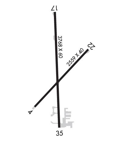
| Rwy | Rwy | |||||||
| 2668x40 | 2559' | 2668x40 | 2668' | |||||
| 3770x60 | 3672' | 3770x60 | 3508' | |||||
| Runway ID | Single Wheel | Double Wheel | Double Tandem Wheel | Dual Double Wheel |
| 04/22 | N/A | N/A | N/A | N/A |
| 18/36 | N/A | N/A | N/A | N/A |
| These numbers are Advisory and are not limits. The Airport Manager should have more accurate Weight Limits | ||||
 Airport Diagram might not be current. | |
| Facility Name: | PORTAGE MUNI |
| City Name: | PORTAGE |
| County: | COLUMBIA |
| State abbrev: | WI |
| State Name: | WISCONSIN |
| Ownership: | PUBLICLY OWNED |
| Use: | OPEN TO THE PUBLIC |
| Owner's Name: | CITY OF PORTAGE |
| Address: | 115 PLEASANT |
| PORTAGE, WI 53901 | |
| Owner's Phone: | 608-742-2176 |
| Manager's Name: | PHIL LIVINGSTON |
| Address: | 115 W PLEASANT ST, BOX 319 |
| PORTAGE, WI 53901 | |
| Phone: | 608-742-2176; EXT 104. |
| FAA Region: | GREAT LAKES |
| FAA Field Office: | CHI |
| Date | Sunrise | Sunset |
|---|---|---|
| 06/08/26 Monday | 5:17 | 20:37 |
| 06/09/26 Tuesday | 5:17 | 20:38 |
| 06/10/26 Wednesday | 5:17 | 20:38 |
| 06/11/26 Thursday | 5:16 | 20:39 |
| 06/12/26 Friday | 5:16 | 20:39 |
| 06/13/26 Saturday | 5:16 | 20:40 |
| 06/14/26 Sunday | 5:16 | 20:40 |
| 06/15/26 Monday | 5:16 | 20:41 |
| 06/16/26 Tuesday | 5:16 | 20:41 |
| 06/17/26 Wednesday | 5:16 | 20:42 |
| 06/18/26 Thursday | 5:16 | 20:42 |
| 06/19/26 Friday | 5:16 | 20:42 |
| 06/20/26 Saturday | 5:16 | 20:42 |
| 06/21/26 Sunday | 5:17 | 20:43 |
| Airport Attendance Schedule | MON-FRI 0900-1500 |
| Airport Status | OPERATIONAL (This Status can change at any time - please check NOTAMS) |
| Airport Lighting Schedule | |
| Airport Storage Available | Tie Downs, Hanger |
| Extra Services Available | Flight Instruction |
| Wind Indicator | YES - (unlit) |
| Control Tower | NO |
| CTAF Frequency | 122.700 |
| Unicom Frequency | 122.700 |
| Rotating Beacon Color | WG |
| Segmented Circle | YES |
| Landing Fee | NO |
| Airport Inspected | STATE - performed by STATE AERONAUTICAL PERSONNEL |
| Inspection Date | 06/07/2023 |
| Type of Fuel Available | Grade 100LLUL91; -10FUEL AVBL 24 HRS WITH CREDIT CARD. |
| Airframe Repair Service | NONE |
| Power Plant Repair Service | NONE |
| Latitude | N4333.6 |
| Longitude | W08929.0 (ESTIMATED) |
| Arpt Elevation | 824ft (SURVEYED) |
| Magnetic Variation | 03W |
| 2 miles NW | of PORTAGE |
| Traffic Pattern Altitude | |
| Sectional Chart | CHICAGO |
| Operations (Reported) | Yearly | Avg. Daily |
|---|---|---|
| General Aviation Transient | 0 | 0 |
| General Aviation Local | 0 | 0 |
| Air Taxi | 0 | 0 |
| Commerical | 0 | 0 |
| Commuter | 0 | 0 |
| Military | 0 | 0 |
| Aircraft based on Field | |
|---|---|
| General Aviation Singles | 0 |
| General Aviation Multi | 0 |
| Jet Aircraft | 0 |
| General Aviation Helicopters | 0 |
| Military Aircraft | 0 |
| Gliders | 0 |
| Ultralights | 0 |
| FSS on field | NO |
| FSS tie-in | GREEN BAY |
| FSS Phone | 1-800-WX-BRIEF |
| Who issues Notams | GRB |
| Notam D service at airport | YES |
| ARTCC Name | CHICAGO |
| Airport Certification | |
| Aircraft Rescue & Firefighting Index | None |
| Airport of Entry | No |
| Custom Landing Rights | No |
| Joint Civil/Military | No |
| Military Landing rights | YES |
| NATIONAL PLAN OF INTEGRATED AIRPORT SYSTEMS (NPIAS) |
| DEER ON & INVOF OF ARPT. |
| RWY 36 LRG HNGRS & TREE 200 FT W OF MAY CAUSE WIND SHEAR WITH STRONG NW WINDS. |
| POWERLINE 110 FT AGL 1580 FT FM DSPLCD THLD RY 36. |
| FOR CD CTC MADISON APP/DEP CON AT 608-249-8240. WHEN MADISON APCH CLSD, FOR CD CTC CHICAGO ARTCC AT 630-906-8921. |
| RWY 04/2 2 RWY NOT PLOWED DURG WINTER, CFM COND WITH AMGR. |
| RWY 18/3 6 MIRL NSTD. RWY 18 FIRST 100 FT NOT LGTD; RWY 36 FIRST 193 FT NOT LGTD. |
Airport Communications & Frequencies:
| |||||||||||||||||||||||||
| Runway: 04 | Runway: 22 | ||
| Mag heading: | 46° | Mag heading: | 226° |
| Rwy Slope: | -.33% Down | Rwy Slope: | .33% Up |
| Approach: | Approach: | ||
| Pattern: | Left Traffic | Pattern: | Left Traffic |
| Markings: | BASIC | Markings: | BASIC |
| Marking Condition: | GOOD | Marking Condition: | GOOD |
| Arresting Dev: | Arresting Dev: | ||
| Lat & Long: | N4333.4 W08929.2 | Lat. & Long.: | N4333.7 W08928.8 |
| Elev: | 824.7 ft. MSL | Elev: | 815.8 ft. MSL |
| TCH: | TCH: | ||
| Visual Glide Path: | Visual Glide Path: | ||
| Displaced Threshold: | 109 feet | Displaced Threshold: | No |
| Touchdown Zone: | YES | Touchdown Zone: | YES |
| Touchdown Elev.: | 824.1 feet | Touchdown Elev.: | 824.8 feet |
| Visual Glide Slope: | Visual Glide Slope: | ||
| RVR Equipment: | RVR Equipment: | ||
| RVV Equipment: | NO | RVV Equipment: | NO |
| Approach Lights: | Approach Lights: | ||
| REIL: | NO | REIL: | NO |
| Centerline Lights: | NO | Centerline Lights: | NO |
| Touchdown lights: | NO | Touchdown lights: | NO |
| Runway Category: | Runway with a Visual Approach | Runway Category: | Runway with a Visual Approach |
| Declared Distances: | Declared Distances: | ||
| Obstructions: | ROAD | Obstructions: | TREES |
| Marked: | NOT Marked/Lighted | Marked: | NOT Marked/Lighted |
| Clearance slope: | CTLG OBSTN EXCEEDS A 45 DEG SLP. | Clearance slope: | 10:1 |
| Obstruction height: | 15 feet AGL | Obstruction height: | 58 feet AGL |
| Dist. from runway: | 200 feet | Dist. from runway: | 814 feet |
| Centerline offset: | 80 right of centerline | Centerline offset: | 164 feet left of centerline |
| Comments: | 30 FT TREES 40 FT FM RWY END; 100 FT L. | Comments: | 6 FT TRRN AT THR; 90 FT L. |
| Runway: 18 | Runway: 36 | ||
| Mag heading: | 181° | Mag heading: | 1° |
| Rwy Slope: | .28% Up | Rwy Slope: | -.28% Down |
| Approach: | Approach: | ||
| Pattern: | Left Traffic | Pattern: | Left Traffic |
| Markings: | NONPRECISION INSTRUMENT | Markings: | NONPRECISION INSTRUMENT |
| Marking Condition: | GOOD | Marking Condition: | GOOD |
| Arresting Dev: | Arresting Dev: | ||
| Lat & Long: | N4333.9 W08929.0 | Lat. & Long.: | N4333.3 W08929.0 |
| Elev: | 811.3 ft. MSL | Elev: | 821.9 ft. MSL |
| TCH: | 40 ft. AGL | TCH: | |
| Visual Glide Path: | 3.75 degrees | Visual Glide Path: | |
| Displaced Threshold: | 98 feet | Displaced Threshold: | 262 feet |
| Touchdown Zone: | YES | Touchdown Zone: | YES |
| Touchdown Elev.: | 819.1 feet | Touchdown Elev.: | 820.6 feet |
| Visual Glide Slope: | 2-Light PAPI on LEFT side of Runway | Visual Glide Slope: | |
| RVR Equipment: | RVR Equipment: | ||
| RVV Equipment: | NO | RVV Equipment: | NO |
| Approach Lights: | Approach Lights: | ||
| REIL: | YES | REIL: | NO |
| Centerline Lights: | NO | Centerline Lights: | NO |
| Touchdown lights: | NO | Touchdown lights: | NO |
| Runway Category: | Runway with a Non-precision Approach | Runway Category: | Runway with a Visual Approach |
| Declared Distances: | Declared Distances: | ||
| Obstructions: | ROAD | Obstructions: | TREES |
| Marked: | NOT Marked/Lighted | Marked: | NOT Marked/Lighted |
| Clearance slope: | APCH RATIO 20:1 TO DSPLCD THR. | Clearance slope: | 1:1; APCH RATIO 10:1 TO DSPLCD THR; 63 FT TREES 587 FT FM DSPLCD THR, 220 L AND 105 FT PLINE 1576 FT FM DSPLCD THR, 70 FT L. |
| Obstruction height: | 2 feet AGL | Obstruction height: | 63 feet AGL |
| Dist. from runway: | 200 feet | Dist. from runway: | 325 feet |
| Centerline offset: | 20 left of centerline | Centerline offset: | 220 feet left of centerline |
| Comments: | 2 FT RD AT RWY END; 170 FT RIGHT. | Comments: | 14 FT RD 42 FT FM RWY END; 28 FT POLE 30 FT FM RWY END, 125 FT L. |
Thanks for using FltPlan.com
all rights reserved © 1999-2026 by Flight Plan LLC
