
| REEDSBURG MUNI REEDSBURG WI |
| |
| Lat: N 4331.6 Long: W 08959.0 Elev: 906 Var: -00 Longest Runway: 4840 | ||
| AWOS: 118.95 CTAF: 122.8 | ||
| ||||||||||||||||||||||||||||||||||||||||||||||||||||||||||||||||||||
| ||||||||||||||||||||||||||||||||||||||||||||||||||||||||||||||||||||
| ||||||||||||||||||||||||||||||||||||||||||||||||||||||||||||||||||||
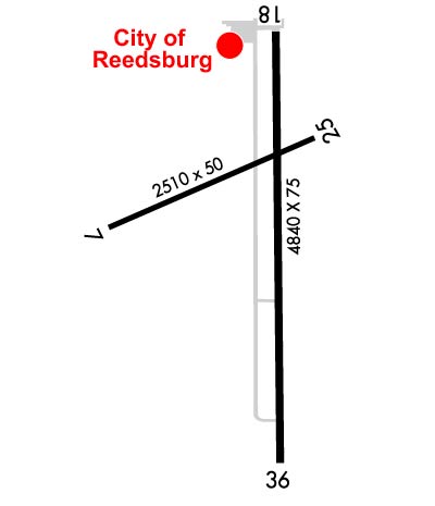
| Rwy | Rwy | |||||||
| 2510x50 | 2281' | 2510x50 | 2210' | |||||
| 4840x75 | 4400' | 4840x75 | 4540' | |||||
| Runway ID | Single Wheel | Double Wheel | Double Tandem Wheel | Dual Double Wheel |
| 07/25 | 30,000 | N/A | N/A | N/A |
| 18/36 | 30,000 | N/A | N/A | N/A |
| These numbers are Advisory and are not limits. The Airport Manager should have more accurate Weight Limits | ||||
 Airport Diagram might not be current. | |
| Facility Name: | REEDSBURG MUNI |
| City Name: | REEDSBURG |
| County: | SAUK |
| State abbrev: | WI |
| State Name: | WISCONSIN |
| Ownership: | PUBLICLY OWNED |
| Use: | OPEN TO THE PUBLIC |
| Owner's Name: | CITY OF REEDSBURG |
| Address: | ARPT COMSN 200 VINE STREET |
| REEDSBURG, WI 53959 | |
| Owner's Phone: | 608-524-2396 |
| Manager's Name: | TOM PARKER |
| Address: | 1720 E MAIN; EMAIL ADDRESS: REEDSBURGAVIATION@GMAIL.COM (ALL LOWER CASE) |
| REEDSBURG, WI 53959 | |
| Phone: | 608-524-2322 |
| FAA Region: | GREAT LAKES |
| FAA Field Office: | CHI |
| Date | Sunrise | Sunset |
|---|---|---|
| 09/24/21 Friday | 6:49 | 18:54 |
| 09/25/21 Saturday | 6:50 | 18:52 |
| 09/26/21 Sunday | 6:51 | 18:50 |
| 09/27/21 Monday | 6:53 | 18:49 |
| 09/28/21 Tuesday | 6:54 | 18:47 |
| 09/29/21 Wednesday | 6:55 | 18:45 |
| 09/30/21 Thursday | 6:56 | 18:43 |
| 10/01/21 Friday | 6:57 | 18:41 |
| 10/02/21 Saturday | 6:58 | 18:40 |
| 10/03/21 Sunday | 6:59 | 18:38 |
| 10/04/21 Monday | 7:01 | 18:36 |
| 10/05/21 Tuesday | 7:02 | 18:34 |
| 10/06/21 Wednesday | 7:03 | 18:32 |
| 10/07/21 Thursday | 7:04 | 18:31 |
| Airport Attendance Schedule | 7 Days A Week 0800-1600 |
| Airport Status | OPERATIONAL (This Status can change at any time - please check NOTAMS) |
| Airport Lighting Schedule | MIRL RYS 18/36 & 07/25 PRESET ON LOW INTST, TO INCR INTST & ACTVT REIL RYS 18 & 36 & PAPI RY 18 - CTAF. |
| Airport Storage Available | Tie Downs, Hanger |
| Extra Services Available | Flight Instruction, Aircraft Rental |
| Wind Indicator | YES - (lighted) |
| Control Tower | NO |
| CTAF Frequency | 122.800 |
| Unicom Frequency | 122.800 |
| Rotating Beacon Color | CLEAR-GREEN (Light Land Airport) |
| Segmented Circle | YES |
| Landing Fee | NO |
| Airport Inspected | STATE - performed by STATE AERONAUTICAL PERSONNEL |
| Inspection Date | 04/09/2021 |
| Type of Fuel Available | Grade 100LL, JET A (freeze point -40C); -1024 HR FUEL AVBL WITH CREDIT CARD. |
| Airframe Repair Service | MAJOR |
| Power Plant Repair Service | MAJOR |
| Latitude | N4331.6 |
| Longitude | W08959.0 (ESTIMATED) |
| Arpt Elevation | 906ft (SURVEYED) |
| Magnetic Variation | 00E |
| 1 miles E | of REEDSBURG |
| Traffic Pattern Altitude | |
| Sectional Chart | CHICAGO |
| Operations (Reported) | Yearly | Avg. Daily |
|---|---|---|
| General Aviation Transient | 7150 | 20 |
| General Aviation Local | 6750 | 18 |
| Air Taxi | 250 | 1 |
| Commerical | 0 | 0 |
| Commuter | 0 | 0 |
| Military | 150 | 0 |
| Aircraft based on Field | |
|---|---|
| General Aviation Singles | 19 |
| General Aviation Multi | 1 |
| Jet Aircraft | 0 |
| General Aviation Helicopters | 0 |
| Military Aircraft | 0 |
| Gliders | 0 |
| Ultralights | 0 |
| FSS on field | NO |
| FSS tie-in | GREEN BAY |
| FSS Phone | 1-800-WX-BRIEF |
| Who issues Notams | GRB |
| Notam D service at airport | YES |
| ARTCC Name | CHICAGO |
| Airport Certification | |
| Aircraft Rescue & Firefighting Index | None |
| Airport of Entry | No |
| Custom Landing Rights | No |
| Joint Civil/Military | No |
| Military Landing rights | YES |
| NATIONAL PLAN OF INTEGRATED AIRPORT SYSTEMS (NPIAS) |
| FOR CD CTC CHICAGO ARTCC AT 630-906-8921. |
Airport Communications & Frequencies:
| |||||||||||||||||
| Runway: 07 | Runway: 25 | ||
| Mag heading: | 69° | Mag heading: | 249° |
| Rwy Slope: | .59% Up | Rwy Slope: | -.59% Down |
| Approach: | Approach: | ||
| Pattern: | Left Traffic | Pattern: | Left Traffic |
| Markings: | BASIC | Markings: | BASIC |
| Marking Condition: | GOOD | Marking Condition: | GOOD |
| Arresting Dev: | Arresting Dev: | ||
| Lat & Long: | N4331.6 W08959.4 | Lat. & Long.: | N4331.7 W08958.8 |
| Elev: | 891.5 ft. MSL | Elev: | 906.2 ft. MSL |
| TCH: | TCH: | ||
| Visual Glide Path: | Visual Glide Path: | ||
| Displaced Threshold: | 229 feet | Displaced Threshold: | 300 feet |
| Touchdown Zone: | YES | Touchdown Zone: | YES |
| Touchdown Elev.: | 906.2 feet | Touchdown Elev.: | 906.2 feet |
| Visual Glide Slope: | Visual Glide Slope: | ||
| RVR Equipment: | RVR Equipment: | ||
| RVV Equipment: | NO | RVV Equipment: | NO |
| Approach Lights: | Approach Lights: | ||
| REIL: | NO | REIL: | NO |
| Centerline Lights: | NO | Centerline Lights: | NO |
| Touchdown lights: | NO | Touchdown lights: | NO |
| Runway Category: | Runway with a Visual Approach | Runway Category: | Runway with a Visual Approach |
| Declared Distances: | TORA:2210' TODA:2210' ASDA:2210' LDA:1980' | Declared Distances: | TORA:2280' TODA:2280' ASDA:2280' LDA:1980' |
| Obstructions: | TREE | Obstructions: | ROAD |
| Marked: | NOT Marked/Lighted | Marked: | NOT Marked/Lighted |
| Clearance slope: | 12:1; APCH RATIO 20:1 TO DSPLCD THR. | Clearance slope: | APCH RATIO 20:1 TO DSPLCD THR. |
| Obstruction height: | 58 feet AGL | Obstruction height: | 12 feet AGL |
| Dist. from runway: | 900 feet | Dist. from runway: | 200 feet |
| Centerline offset: | 200 left of centerline | Centerline offset: | |
| Comments: | DITCH 10 FT FM RWY END 60 FT L. | Comments: | 10 FT FENCE 175 FT FM RWY END, 40 FT L. |
| Runway: 18 | Runway: 36 | ||
| Mag heading: | 181° | Mag heading: | 1° |
| Rwy Slope: | -.49% Down | Rwy Slope: | .49% Up |
| Approach: | Approach: | ||
| Pattern: | Left Traffic | Pattern: | Left Traffic |
| Markings: | NONPRECISION INSTRUMENT | Markings: | NONPRECISION INSTRUMENT |
| Marking Condition: | GOOD | Marking Condition: | GOOD |
| Arresting Dev: | Arresting Dev: | ||
| Lat & Long: | N4331.9 W08958.9 | Lat. & Long.: | N4331.1 W08958.9 |
| Elev: | 904.9 ft. MSL | Elev: | 881.4 ft. MSL |
| TCH: | 25 ft. AGL | TCH: | |
| Visual Glide Path: | 3.00 degrees | Visual Glide Path: | |
| Displaced Threshold: | 440 feet | Displaced Threshold: | 300 feet |
| Touchdown Zone: | YES | Touchdown Zone: | YES |
| Touchdown Elev.: | 904.5 feet | Touchdown Elev.: | 902.9 feet |
| Visual Glide Slope: | 2-Light PAPI on LEFT side of Runway | Visual Glide Slope: | |
| RVR Equipment: | RVR Equipment: | ||
| RVV Equipment: | NO | RVV Equipment: | NO |
| Approach Lights: | Approach Lights: | ||
| REIL: | YES | REIL: | YES |
| Centerline Lights: | NO | Centerline Lights: | NO |
| Touchdown lights: | NO | Touchdown lights: | NO |
| Runway Category: | Runway with a Non-precision Approach having visibility minimums greater than 3/4 mile | Runway Category: | Runway with a Non-precision Approach having visibility minimums greater than 3/4 mile |
| Declared Distances: | TORA:4540' TODA:4540' ASDA:4540' LDA:4100' | Declared Distances: | TORA:4400' TODA:4400' ASDA:4400' LDA:4100' |
| Obstructions: | ROAD | Obstructions: | RR |
| Marked: | NOT Marked/Lighted | Marked: | NOT Marked/Lighted |
| Clearance slope: | 1:1; APCH RATIO 25:1 TO DSPLCD THR. | Clearance slope: | APCH RATIO 20:1 TO DSPLCD THR. |
| Obstruction height: | 21 feet AGL | Obstruction height: | 17 feet AGL |
| Dist. from runway: | 230 feet | Dist. from runway: | 200 feet |
| Centerline offset: | Centerline offset: | 180 feet left of centerline | |
| Comments: | 10 FT FENCE 190 FT FM RWY END, 120 FT R. | Comments: | 17 FT RR 75 FT FM RWY END 250 FT L. |
Thanks for using FltPlan.com
all rights reserved © 1999-2021 by Flight Plan LLC


