| FRASCA FIELD URBANA IL |
| |
| Lat: N 4008.8 Long: W 08811.9 Elev: 735 Var: -02 Longest Runway: 4001 | ||
| CTAF: 122.8 | ||
| |||||||||||||||||||||||||||||||||||||||||||||||||||||||||||||
| |||||||||||||||||||||||||||||||||||||||||||||||||||||||||||||
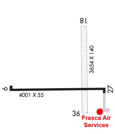
| Rwy | Rwy | |||||||
| 4001x55 | 4001' | 4001x55 | 4001' | |||||
| 3654x140 | 3654' | 3654x140 | 3336' | |||||
| Runway ID | Single Wheel | Double Wheel | Double Tandem Wheel | Dual Double Wheel |
| 09/27 | N/A | N/A | N/A | N/A |
| 18/36 | N/A | N/A | N/A | N/A |
| These numbers are Advisory and are not limits. The Airport Manager should have more accurate Weight Limits | ||||
 Airport Diagram might not be current. | |
| Facility Name: | FRASCA FLD |
| City Name: | URBANA |
| County: | CHAMPAIGN |
| State abbrev: | IL |
| State Name: | ILLINOIS |
| Ownership: | PRIVATELY OWNED |
| Use: | OPEN TO THE PUBLIC |
| Owner's Name: | FRASCA AIR SERVICE INC |
| Address: | 1402 E AIRPORT ROAD |
| URBANA, IL 61801 | |
| Owner's Phone: | 217-367-8441 |
| Manager's Name: | TOM FRASCA |
| Address: | 1402 E ARPT RD; EMAIL ADDRESS: TFRASCA@FRASCA.COM (ALL LOWER CASE) |
| URBANA, IL 61801 | |
| Phone: | 217-367-8441 |
| FAA Region: | GREAT LAKES |
| FAA Field Office: | CHI |
| Date | Sunrise | Sunset |
|---|---|---|
| 04/25/24 Thursday | 5:59 | 19:43 |
| 04/26/24 Friday | 5:58 | 19:44 |
| 04/27/24 Saturday | 5:57 | 19:45 |
| 04/28/24 Sunday | 5:55 | 19:46 |
| 04/29/24 Monday | 5:54 | 19:47 |
| 04/30/24 Tuesday | 5:53 | 19:48 |
| 05/01/24 Wednesday | 5:52 | 19:49 |
| 05/02/24 Thursday | 5:50 | 19:50 |
| 05/03/24 Friday | 5:49 | 19:51 |
| 05/04/24 Saturday | 5:48 | 19:52 |
| 05/05/24 Sunday | 5:47 | 19:53 |
| 05/06/24 Monday | 5:46 | 19:54 |
| 05/07/24 Tuesday | 5:45 | 19:55 |
| 05/08/24 Wednesday | 5:43 | 19:56 |
| Airport Attendance Schedule | 7 Days A Week DAWN-DUSK |
| Airport Status | OPERATIONAL (This Status can change at any time - please check NOTAMS) |
| Airport Lighting Schedule | SS-SR |
| Airport Storage Available | Tie Downs, Hanger |
| Extra Services Available | NONE |
| Wind Indicator | YES - (lighted) |
| Control Tower | NO |
| CTAF Frequency | 122.800 |
| Unicom Frequency | 122.800 |
| Rotating Beacon Color | |
| Segmented Circle | YES |
| Landing Fee | NO |
| Airport Inspected | STATE - performed by STATE AERONAUTICAL PERSONNEL |
| Inspection Date | 08/29/2023 |
| Type of Fuel Available | Grade 100LL, JET A (freeze point -40C) |
| Airframe Repair Service | NONE |
| Power Plant Repair Service | NONE |
| Latitude | N4008.8 |
| Longitude | W08811.9 (ESTIMATED) |
| Arpt Elevation | 735ft (SURVEYED) |
| Magnetic Variation | 02E |
| 1 miles N | of URBANA |
| Traffic Pattern Altitude | |
| Sectional Chart | CHICAGO |
| Operations (Reported) | Yearly | Avg. Daily |
|---|---|---|
| General Aviation Transient | 4000 | 11 |
| General Aviation Local | 9500 | 26 |
| Air Taxi | 1500 | 4 |
| Commerical | 0 | 0 |
| Commuter | 0 | 0 |
| Military | 0 | 0 |
| Aircraft based on Field | |
|---|---|
| General Aviation Singles | 60 |
| General Aviation Multi | 3 |
| Jet Aircraft | 0 |
| General Aviation Helicopters | 1 |
| Military Aircraft | 0 |
| Gliders | 1 |
| Ultralights | 0 |
| FSS on field | NO |
| FSS tie-in | SAINT LOUIS |
| FSS Phone | 1-800-WX-BRIEF |
| Who issues Notams | STL |
| Notam D service at airport | YES |
| ARTCC Name | CHICAGO |
| Airport Certification | |
| Aircraft Rescue & Firefighting Index | None |
| Airport of Entry | No |
| Custom Landing Rights | No |
| Joint Civil/Military | No |
| Military Landing rights | No |
| FOR CD CTC CHAMPAIGN APCH AT 217-355-4071, WHEN APCH CLSD CTC CHICAGO ARTCC AT 630-906-8921 |
Airport Communications & Frequencies:
| |||||||||||||||||
| Runway: 09 | Runway: 27 | ||
| Mag heading: | 87° | Mag heading: | 267° |
| Rwy Slope: | -.26% Down | Rwy Slope: | .26% Up |
| Approach: | Approach: | ||
| Pattern: | Left Traffic | Pattern: | Right Traffic |
| Markings: | BASIC | Markings: | BASIC |
| Marking Condition: | FAIR | Marking Condition: | FAIR |
| Arresting Dev: | Arresting Dev: | ||
| Lat & Long: | N4008.7 W08812.5 | Lat. & Long.: | N4008.7 W08811.6 |
| Elev: | 734.6 ft. MSL | Elev: | 724.3 ft. MSL |
| TCH: | TCH: | ||
| Visual Glide Path: | Visual Glide Path: | ||
| Displaced Threshold: | No | Displaced Threshold: | No |
| Touchdown Zone: | YES | Touchdown Zone: | NO |
| Touchdown Elev.: | 735.0 feet | Touchdown Elev.: | |
| Visual Glide Slope: | Visual Glide Slope: | ||
| RVR Equipment: | RVR Equipment: | ||
| RVV Equipment: | NO | RVV Equipment: | NO |
| Approach Lights: | Approach Lights: | ||
| REIL: | NO | REIL: | NO |
| Centerline Lights: | NO | Centerline Lights: | NO |
| Touchdown lights: | NO | Touchdown lights: | NO |
| Runway Category: | Runway with a Visual Approach | Runway Category: | Runway with a Visual Approach |
| Declared Distances: | Declared Distances: |
| Runway: 18 | Runway: 36 | ||
| Mag heading: | 177° | Mag heading: | 357° |
| Rwy Slope: | .09% Up | Rwy Slope: | -.09% Down |
| Approach: | Approach: | ||
| Pattern: | Left Traffic | Pattern: | Left Traffic |
| Markings: | Markings: | ||
| Marking Condition: | Marking Condition: | ||
| Arresting Dev: | Arresting Dev: | ||
| Lat & Long: | N4009.2 W08811.8 | Lat. & Long.: | N4008.6 W08811.8 |
| Elev: | 728.0 ft. MSL | Elev: | 731.3 ft. MSL |
| TCH: | TCH: | ||
| Visual Glide Path: | Visual Glide Path: | ||
| Displaced Threshold: | No | Displaced Threshold: | 318 feet |
| Touchdown Zone: | NO | Touchdown Zone: | NO |
| Touchdown Elev.: | Touchdown Elev.: | ||
| Visual Glide Slope: | Visual Glide Slope: | ||
| RVR Equipment: | RVR Equipment: | ||
| RVV Equipment: | NO | RVV Equipment: | NO |
| Approach Lights: | Approach Lights: | ||
| REIL: | NO | REIL: | NO |
| Centerline Lights: | NO | Centerline Lights: | NO |
| Touchdown lights: | NO | Touchdown lights: | NO |
| Runway Category: | Runway with a Visual Approach | Runway Category: | Runway with a Visual Approach |
| Declared Distances: | Declared Distances: | ||
| Obstructions: | Obstructions: | POLE | |
| Marked: | Marked: | NOT Marked/Lighted | |
| Clearance slope: | 20:1 | Clearance slope: | 10:1; APPCH RATIO IS 20:1 TO THE DSPLCD THLD. |
| Obstruction height: | Obstruction height: | 38 feet AGL | |
| Dist. from runway: | Dist. from runway: | 416 feet | |
| Centerline offset: | Centerline offset: | 101 feet right of centerline | |
| Comments: | Comments: |
Thanks for using FltPlan.com
all rights reserved © 1999-2024 by Flight Plan LLC