
| GRAND GENEVA RESORT LAKE GENEVA WI |
| |
| Lat: N 4236.9 Long: W 08823.4 Elev: 835 Var: +04 Longest Runway: 4100 | ||
| CTAF: 122.8 | ||
| ||||||||||||||||||||||||||||||||
| ||||||||||||||||||||||||||||||||
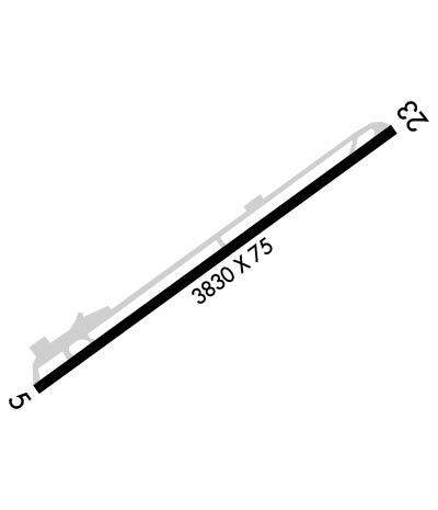
| Rwy | Rwy | |||||||
| 4100x75 | 4100' | 4100x75 | 4100' | |||||
| Runway ID | Single Wheel | Double Wheel | Double Tandem Wheel | Dual Double Wheel |
| 05/23 | N/A | N/A | N/A | N/A |
| These numbers are Advisory and are not limits. The Airport Manager should have more accurate Weight Limits | ||||
 Airport Diagram might not be current. | |
| Facility Name: | GRAND GENEVA RESORT |
| City Name: | LAKE GENEVA |
| County: | WALWORTH |
| State abbrev: | WI |
| State Name: | WISCONSIN |
| Ownership: | PRIVATELY OWNED |
| Use: | OPEN TO THE PUBLIC |
| Owner's Name: | GRAND GENEVA RESORT |
| Address: | 7036 GRAND GENEVA WAY |
| LAKE GENEVA, WI 53147-0130 | |
| Owner's Phone: | 262-249-7905 |
| Manager's Name: | JIM CROTHERS |
| Address: | 7036 GRAND GENEVA WAY |
| LAKE GENEVA, WI 53147-0130 | |
| Phone: | 262-249-4738 |
| FAA Region: | GREAT LAKES |
| FAA Field Office: | CHI |
| Date | Sunrise | Sunset |
|---|---|---|
| 09/24/21 Friday | 6:43 | 18:48 |
| 09/25/21 Saturday | 6:44 | 18:46 |
| 09/26/21 Sunday | 6:45 | 18:44 |
| 09/27/21 Monday | 6:46 | 18:42 |
| 09/28/21 Tuesday | 6:47 | 18:41 |
| 09/29/21 Wednesday | 6:48 | 18:39 |
| 09/30/21 Thursday | 6:49 | 18:37 |
| 10/01/21 Friday | 6:50 | 18:35 |
| 10/02/21 Saturday | 6:52 | 18:34 |
| 10/03/21 Sunday | 6:53 | 18:32 |
| 10/04/21 Monday | 6:54 | 18:30 |
| 10/05/21 Tuesday | 6:55 | 18:28 |
| 10/06/21 Wednesday | 6:56 | 18:27 |
| 10/07/21 Thursday | 6:57 | 18:25 |
| Airport Attendance Schedule | UNATTENDED |
| Airport Status | OPERATIONAL (This Status can change at any time - please check NOTAMS) |
| Airport Lighting Schedule | MIRL RY 05/23 PRESET ON MED INTST SS-SR. |
| Airport Storage Available | Tie Downs |
| Extra Services Available | NONE |
| Wind Indicator | YES - (lighted) |
| Control Tower | NO |
| CTAF Frequency | 122.800 |
| Unicom Frequency | 122.800 |
| Rotating Beacon Color | |
| Segmented Circle | YES |
| Landing Fee |
| Airport Inspected | No Inspection Data Available performed by STATE AERONAUTICAL PERSONNEL |
| Inspection Date | 05/05/2021 |
| Type of Fuel Available | None |
| Airframe Repair Service | NONE |
| Power Plant Repair Service | NONE |
| Latitude | N4236.9 |
| Longitude | W08823.4 (ESTIMATED) |
| Arpt Elevation | 835ft (ESTIMATED) |
| Magnetic Variation | 04W |
| 2 miles ENE | of LAKE GENEVA |
| Traffic Pattern Altitude | |
| Sectional Chart | CHICAGO |
| Operations (Reported) | Yearly | Avg. Daily |
|---|---|---|
| General Aviation Transient | 100 | 0 |
| General Aviation Local | 0 | 0 |
| Air Taxi | 50 | 0 |
| Commerical | 0 | 0 |
| Commuter | 0 | 0 |
| Military | 0 | 0 |
| Aircraft based on Field | |
|---|---|
| General Aviation Singles | 1 |
| General Aviation Multi | 1 |
| Jet Aircraft | 0 |
| General Aviation Helicopters | 1 |
| Military Aircraft | 0 |
| Gliders | 1 |
| Ultralights | 0 |
| FSS on field | NO |
| FSS tie-in | GREEN BAY |
| FSS Phone | 1-800-WX-BRIEF |
| Who issues Notams | GRB |
| Notam D service at airport | YES |
| ARTCC Name | CHICAGO |
| Airport Certification | |
| Aircraft Rescue & Firefighting Index | None |
| Airport of Entry | No |
| Custom Landing Rights | No |
| Joint Civil/Military | No |
| Military Landing rights | No |
| FOR NOISE ABATEMENT USE RY 23. |
| ARPT CLSD DEC 1 THRU APR 5, UFN. |
| FOR CD CTC CHICAGO ARTCC AT 630-906-8921. |
| RWY 05/2 3 EXTENSIVE CRACKING ENTIRE RY. |
Airport Communications & Frequencies:
|
| Runway: 05 | Runway: 23 | ||
| Mag heading: | 57° | Mag heading: | 237° |
| Rwy Slope: | .00% Up | Rwy Slope: | .00% Down |
| Approach: | Approach: | ||
| Pattern: | Right Traffic | Pattern: | Left Traffic |
| Markings: | NONPRECISION INSTRUMENT | Markings: | NONPRECISION INSTRUMENT |
| Marking Condition: | FAIR | Marking Condition: | FAIR |
| Arresting Dev: | Arresting Dev: | ||
| Lat & Long: | N4236.7 W08823.8 | Lat. & Long.: | N4237.1 W08823.0 |
| Elev: | 834.5 ft. MSL | Elev: | 834.7 ft. MSL |
| TCH: | TCH: | ||
| Visual Glide Path: | Visual Glide Path: | ||
| Displaced Threshold: | No | Displaced Threshold: | No |
| Touchdown Zone: | YES | Touchdown Zone: | YES |
| Touchdown Elev.: | 835.4 feet | Touchdown Elev.: | 835.4 feet |
| Visual Glide Slope: | Visual Glide Slope: | ||
| RVR Equipment: | RVR Equipment: | ||
| RVV Equipment: | NO | RVV Equipment: | NO |
| Approach Lights: | Approach Lights: | ||
| REIL: | NO | REIL: | NO |
| Centerline Lights: | NO | Centerline Lights: | NO |
| Touchdown lights: | NO | Touchdown lights: | NO |
| Runway Category: | Runway with a Visual Approach | Runway Category: | Runway with a Non-precision Approach |
| Declared Distances: | Declared Distances: | ||
| Obstructions: | ROAD | Obstructions: | TREES |
| Marked: | NOT Marked/Lighted | Marked: | NOT Marked/Lighted |
| Clearance slope: | APCH RATIO 12:1 TO DSPLCD THR; 53 FT TREE 640 FT FM DSPCLD THR, 100 FT L. | Clearance slope: | |
| Obstruction height: | 15 feet AGL | Obstruction height: | 50 feet AGL |
| Dist. from runway: | 200 feet | Dist. from runway: | 200 feet |
| Centerline offset: | 50 right of centerline | Centerline offset: | 150 feet left of centerline |
| Comments: | ROADS 0-200 FT FM RWY END, 50 L/R. | Comments: | 30-50 FT TREES 0-200 FT FM THR. |
Thanks for using FltPlan.com
all rights reserved © 1999-2021 by Flight Plan LLC
