
| BOZEMAN YELLOWSTONE INTL BOZEMAN MT |
| |
| Lat: N 4546.6 Long: W 11109.0 Elev: 4473 Var: -13 Longest Runway: 8994 | ||
| Clr Del: 124.05 Dept. ATIS: 135.42 Arr. ATIS: 135.42 AWOS: 135.42 Ground: 121.8 Tower: 118.2 | ||
| |||||||||||||||||||||||||||||||||||||||||||||||||||||||||||||||||||||
| |||||||||||||||||||||||||||||||||||||||||||||||||||||||||||||||||||||
| |||||||||||||||||||||||||||||||||||||||||||||||||||||||||||||||||||||
| |||||||||||||||||||||||||||||||||||||||||||||||||||||||||||||||||||||
| |||||||||||||||||||||||||||||||||||||||||||||||||||||||||||||||||||||
| |||||||||||||||||||||||||||||||||||||||||||||||||||||||||||||||||||||
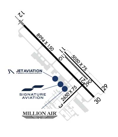
| FBOs at nearby airports who want your business: | |||||||||||||||||
| |||||||||||||||||
| Rwy | Rwy | |||||||
| 2650x75 | 2650' | 2650x75 | 2650' | |||||
| 5050x75 | 5050' | 5050x75 | 5050' | |||||
| 2802x80 | 2802' | 2802x80 | 2802' | |||||
| 8994x150 | 8994' | 109.30 - 122° | 8994x150 | 8994' | ||||
| Runway ID | Single Wheel | Double Wheel | Double Tandem Wheel | Dual Double Wheel |
| 03/21 | 12,500 | N/A | N/A | N/A |
| 11/29 | 12,500 | N/A | N/A | N/A |
| 11G/29G | N/A | N/A | N/A | N/A |
| 12/30 | 120,000 | 250,000 | 550,000 | 1,120,000 |
| These numbers are Advisory and are not limits. The Airport Manager should have more accurate Weight Limits | ||||
 Airport Diagram might not be current. | |
| Facility Name: | BOZEMAN YELLOWSTONE INTL |
| City Name: | BOZEMAN |
| County: | GALLATIN |
| State abbrev: | MT |
| State Name: | MONTANA |
| Ownership: | PUBLICLY OWNED |
| Use: | OPEN TO THE PUBLIC |
| Owner's Name: | GALLATIN AIRPORT AUTHORITY |
| Address: | 850 GALLATIN FIELD RD, SUITE 6 |
| BELGRADE, MT 59714 | |
| Owner's Phone: | 406-388-6632 |
| Manager's Name: | BRIAN SPRENGER |
| Address: | 850 GALLATIN FIELD RD, SUITE 6 |
| BELGRADE, MT 59714 | |
| Phone: | 406-388-6632 |
| FAA Region: | NORTHWEST MOUNTAIN |
| FAA Field Office: | HLN |
| Date | Sunrise | Sunset |
|---|---|---|
| 06/08/26 Monday | 5:35 | 21:12 |
| 06/09/26 Tuesday | 5:35 | 21:13 |
| 06/10/26 Wednesday | 5:35 | 21:14 |
| 06/11/26 Thursday | 5:34 | 21:14 |
| 06/12/26 Friday | 5:34 | 21:15 |
| 06/13/26 Saturday | 5:34 | 21:15 |
| 06/14/26 Sunday | 5:34 | 21:16 |
| 06/15/26 Monday | 5:34 | 21:16 |
| 06/16/26 Tuesday | 5:34 | 21:17 |
| 06/17/26 Wednesday | 5:34 | 21:17 |
| 06/18/26 Thursday | 5:34 | 21:17 |
| 06/19/26 Friday | 5:34 | 21:18 |
| 06/20/26 Saturday | 5:34 | 21:18 |
| 06/21/26 Sunday | 5:35 | 21:18 |
| Airport Attendance Schedule | 7 Days A Week 0430-0100 |
| Airport Status | OPERATIONAL (This Status can change at any time - please check NOTAMS) |
| Airport Lighting Schedule | WHEN ATCT CLSD ACTVT MALSR RWY 12 & 30; HIRL RWY 12/30; MIRL RWY 11/29 - CTAF. PAPI RWY 12 & 30 OPR CONSLY. |
| Airport Storage Available | Tie Downs, Hanger |
| Extra Services Available | Air Freight, Crop Dusting, Charter, Glider, Flight Instruction, Parachute Jumping, Aircraft Rental, Aircraft Sales, Annual Surveying, Glider Towing |
| Wind Indicator | YES - (lighted) |
| Control Tower | YES |
| CTAF Frequency | 118.200 |
| Unicom Frequency | 122.950 |
| Rotating Beacon Color | WG |
| Segmented Circle | NO |
| Landing Fee | YES |
| Airport Inspected | FEDERAL - performed by FAA AIRPORTS FIELD PERSONNEL |
| Inspection Date | 05/09/2025 |
| Type of Fuel Available | Grade 100, Grade 100LL, JET A (freeze point -40C) |
| Airframe Repair Service | MAJOR |
| Power Plant Repair Service | MAJOR |
| Latitude | N4546.6 |
| Longitude | W11109.0 (ESTIMATED) |
| Arpt Elevation | 4473ft (SURVEYED) |
| Magnetic Variation | 13E |
| 7 miles NW | of BOZEMAN |
| Traffic Pattern Altitude | |
| Sectional Chart | GREAT FALLS |
| Operations (Reported) | Yearly | Avg. Daily |
|---|---|---|
| General Aviation Transient | 0 | 0 |
| General Aviation Local | 0 | 0 |
| Air Taxi | 0 | 0 |
| Commerical | 0 | 0 |
| Commuter | 0 | 0 |
| Military | 0 | 0 |
| Aircraft based on Field | |
|---|---|
| General Aviation Singles | 0 |
| General Aviation Multi | 0 |
| Jet Aircraft | 0 |
| General Aviation Helicopters | 0 |
| Military Aircraft | 0 |
| Gliders | 0 |
| Ultralights | 0 |
| FSS on field | NO |
| FSS tie-in | GREAT FALLS |
| FSS Phone | 1-800-WX-BRIEF |
| Who issues Notams | BZN |
| Notam D service at airport | YES |
| ARTCC Name | SALT LAKE CITY |
| Airport Certification | AIRPORT RECEIVING SCHEDULED AIR CARRIER SERVICE FROM CARRIERS CERTIFICATED BY THE CIVIL AERONAUTICS BOARD |
| Aircraft Rescue & Firefighting Index | AIRPORT HAS A CERTIFICATE UNDER CFR PART 139 |
| Airport of Entry | No |
| Custom Landing Rights | No; US CUSTOMS USER FEE ARPT. |
| Joint Civil/Military | No |
| Military Landing rights | YES |
| NATIONAL PLAN OF INTEGRATED AIRPORT SYSTEMS (NPIAS) |
| GRANT AGREEMENTS UNDER FAAP/ADAP/AIP |
| ASSURANCES PURSUANT TO TITLE VI, CIVIL RIGHTS ACT OF 1964 |
| AGREEMENT UNDER DLAND OR DCLA HAS EXPIRED. |
| BIRDS INVOF ARPT. |
| STUDENT TRNG ACT WI 15 MI. |
| 180 DEG TURN NA ON TRML RAMP. |
| PILOTS CONDUCTING EFVS OPS; BE AWARE LED ALS IN USE RWY 12. |
| FOR CD WHEN ATCT CLSD CTC BIG SKY APCH AT 208-364-5860, WHEN ATCT AND APCH CLSD CTC SALT LAKE ARTCC AT 801-320-2568. |
| NOISE: TRAINING TRAFFIC - CHECK VOLUNTARY NOISE ABATEMENT PRO |
| SNOW REMOVAL EQUIP - CTAF. |
| COLD TEMPERATURE AIRPORT. ALTITUDE CORRECTION REQUIRED AT OR BELOW -21C. |
| RWY 11G/ 29G240 FT S OF RWY 11/29; AVBL WHEN DRY WITH ATC APVL. |
| RWY 03 TKOF NA UNTIL CFMG NO TFC USING RWY 12. |
| RWY 12 ARR & DEP OPS WHEN WIND LESS THAN 10 KT; OTR RWY MAY BE USED; EXPC DLA. |
| RWY 21 LCTD BTN RWY 12/30 & TWY A; AVBL GTR THAN 12500 LB DAY/VFR ONLY. |
| RWY 03/2 1 PCR VALUE: 465/F/A/X/U |
| RWY 11/2 9 PCR VALUE: 260/F/A/X/U |
| RWY 12/3 0 PCR VALUE: 1410/F/A/X/U |
Airport Communications & Frequencies:
| |||||||||||||||||||||||||
| Runway: 03 | Runway: 21 | ||
| Mag heading: | 33° | Mag heading: | 213° |
| Rwy Slope: | -.71% Down | Rwy Slope: | .71% Up |
| Approach: | Approach: | ||
| Pattern: | Left Traffic | Pattern: | Left Traffic |
| Markings: | BASIC | Markings: | BASIC |
| Marking Condition: | GOOD | Marking Condition: | GOOD |
| Arresting Dev: | Arresting Dev: | ||
| Lat & Long: | N4546.1 W11109.2 | Lat. & Long.: | N4546.4 W11108.7 |
| Elev: | 4473.4 ft. MSL | Elev: | 4454.7 ft. MSL |
| TCH: | TCH: | ||
| Visual Glide Path: | Visual Glide Path: | ||
| Displaced Threshold: | No | Displaced Threshold: | No |
| Touchdown Zone: | YES | Touchdown Zone: | YES |
| Touchdown Elev.: | 4473.4 feet | Touchdown Elev.: | 4473.4 feet |
| Visual Glide Slope: | Visual Glide Slope: | ||
| RVR Equipment: | RVR Equipment: | ||
| RVV Equipment: | NO | RVV Equipment: | NO |
| Approach Lights: | Approach Lights: | ||
| REIL: | NO | REIL: | NO |
| Centerline Lights: | NO | Centerline Lights: | NO |
| Touchdown lights: | NO | Touchdown lights: | NO |
| Runway Category: | Runway with a Visual Approach | Runway Category: | Runway with a Visual Approach |
| Declared Distances: | TORA:2650' TODA:2650' ASDA:2650' LDA:2650' | Declared Distances: | TORA:2650' TODA:2650' ASDA:2650' LDA:2650' |
| Runway: 11 | Runway: 29 | ||
| Mag heading: | 123° | Mag heading: | 303° |
| Rwy Slope: | .39% Up | Rwy Slope: | -.39% Down |
| Approach: | Approach: | ||
| Pattern: | Left Traffic | Pattern: | Left Traffic |
| Markings: | BASIC | Markings: | BASIC |
| Marking Condition: | GOOD | Marking Condition: | GOOD |
| Arresting Dev: | Arresting Dev: | ||
| Lat & Long: | N4546.9 W11109.1 | Lat. & Long.: | N4546.3 W11108.3 |
| Elev: | 4441.8 ft. MSL | Elev: | 4461.4 ft. MSL |
| TCH: | 42 ft. AGL | TCH: | 47 ft. AGL |
| Visual Glide Path: | 3.00 degrees | Visual Glide Path: | 3.00 degrees |
| Displaced Threshold: | No | Displaced Threshold: | No |
| Touchdown Zone: | YES | Touchdown Zone: | YES |
| Touchdown Elev.: | 4452.8 feet | Touchdown Elev.: | 4461.4 feet |
| Visual Glide Slope: | 4-Light PAPI on LEFT side of Runway | Visual Glide Slope: | 4-Light PAPI on LEFT side of Runway |
| RVR Equipment: | RVR Equipment: | ||
| RVV Equipment: | NO | RVV Equipment: | NO |
| Approach Lights: | Approach Lights: | ||
| REIL: | NO | REIL: | NO |
| Centerline Lights: | NO | Centerline Lights: | NO |
| Touchdown lights: | NO | Touchdown lights: | NO |
| Runway Category: | Runway with a Visual Approach | Runway Category: | Runway with a Visual Approach |
| Declared Distances: | TORA:5050' TODA:5050' ASDA:5050' LDA:5050' | Declared Distances: | TORA:5050' TODA:5050' ASDA:5050' LDA:5050' |
| Runway: 11G | Runway: 29G | ||
| Mag heading: | 123° | Mag heading: | 303° |
| Rwy Slope: | .32% Up | Rwy Slope: | -.32% Down |
| Approach: | Approach: | ||
| Pattern: | Left Traffic | Pattern: | Left Traffic |
| Markings: | NONSTANDARD | Markings: | NONSTANDARD |
| Marking Condition: | CONES. | Marking Condition: | CONES. |
| Arresting Dev: | Arresting Dev: | ||
| Lat & Long: | N4546.8 W11109.1 | Lat. & Long.: | N4546.5 W11108.7 |
| Elev: | 4444.2 ft. MSL | Elev: | 4453.2 ft. MSL |
| TCH: | TCH: | ||
| Visual Glide Path: | Visual Glide Path: | ||
| Displaced Threshold: | No | Displaced Threshold: | No |
| Touchdown Zone: | YES | Touchdown Zone: | YES |
| Touchdown Elev.: | 4446.3 feet | Touchdown Elev.: | 4453.2 feet |
| Visual Glide Slope: | Visual Glide Slope: | ||
| RVR Equipment: | RVR Equipment: | ||
| RVV Equipment: | NO | RVV Equipment: | NO |
| Approach Lights: | Approach Lights: | ||
| REIL: | NO | REIL: | NO |
| Centerline Lights: | NO | Centerline Lights: | NO |
| Touchdown lights: | NO | Touchdown lights: | NO |
| Runway Category: | Runway with a Visual Approach | Runway Category: | Runway with a Visual Approach |
| Declared Distances: | Declared Distances: |
| Runway: 12 | Runway: 30 | ||
| Mag heading: | 123° | Mag heading: | 303° |
| Rwy Slope: | .42% Up | Rwy Slope: | -.42% Down |
| Approach: | ILS | Approach: | |
| Pattern: | Left Traffic | Pattern: | Left Traffic |
| Markings: | PRECISION INSTRUMENT | Markings: | PRECISION INSTRUMENT |
| Marking Condition: | GOOD | Marking Condition: | GOOD |
| Arresting Dev: | Arresting Dev: | ||
| Lat & Long: | N4547.3 W11110.0 | Lat. & Long.: | N4546.2 W11108.5 |
| Elev: | 4424.9 ft. MSL | Elev: | 4462.3 ft. MSL |
| TCH: | 53 ft. AGL | TCH: | 50 ft. AGL |
| Visual Glide Path: | 3.00 degrees | Visual Glide Path: | 3.20 degrees |
| Displaced Threshold: | No | Displaced Threshold: | No |
| Touchdown Zone: | YES | Touchdown Zone: | YES |
| Touchdown Elev.: | 4442.7 feet | Touchdown Elev.: | 4462.4 feet |
| Visual Glide Slope: | 4-Light PAPI on LEFT side of Runway | Visual Glide Slope: | 4-Light PAPI on LEFT side of Runway |
| RVR Equipment: | TOUCHDOWN-MIDFIELD-ROLLOUT | RVR Equipment: | TOUCHDOWN-MIDFIELD-ROLLOUT |
| RVV Equipment: | NO | RVV Equipment: | NO |
| Approach Lights: | MALSR - 1,400 foot medium intensity approach lighting system with runway alignment indicator lights | Approach Lights: | MALSR - 1,400 foot medium intensity approach lighting system with runway alignment indicator lights |
| REIL: | NO | REIL: | NO |
| Centerline Lights: | NO | Centerline Lights: | NO |
| Touchdown lights: | NO | Touchdown lights: | NO |
| Runway Category: | Precision Instrument Runway | Runway Category: | Runway with a Non-precision Approach having visibility minimums greater than 3/4 mile |
| Declared Distances: | TORA:8994' TODA:8994' ASDA:8994' LDA:8994' | Declared Distances: | TORA:8994' TODA:8994' ASDA:8994' LDA:8994' |
Thanks for using FltPlan.com
all rights reserved © 1999-2026 by Flight Plan LLC