
| ARKANSAS INTL BLYTHEVILLE AR |
| |
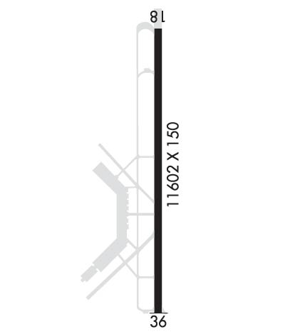
| Lat: N 3557.9 Long: W 08956.6 Elev: 254 Var: +01 Longest Runway: 11602 | ||
| CTAF: 122.7 | ||
| ||||||
|
| Rwy | Rwy | |||||||
| 11602x150 | 11602' | 110.30 - 181° | 11602x150 | 11602' | ||||
| Runway ID | Single Wheel | Double Wheel | Double Tandem Wheel | Dual Double Wheel |
| 18/36 | 155,000 | 235,000 | 455,000 | N/A |
| These numbers are Advisory and are not limits. The Airport Manager should have more accurate Weight Limits | ||||
 Airport Diagram might not be current. | |
| Facility Name: | ARKANSAS INTL |
| City Name: | BLYTHEVILLE |
| County: | MISSISSIPPI |
| State abbrev: | AR |
| State Name: | ARKANSAS |
| Ownership: | PUBLICLY OWNED |
| Use: | OPEN TO THE PUBLIC |
| Owner's Name: | GOSNELL REG AIRPORT AUTHORITY |
| Address: | 4701 MEMORIAL DRIVE |
| BLYTHEVILLE, AR 72315-0166 | |
| Owner's Phone: | 870-532-2100 |
| Manager's Name: | TODD RILEY |
| Address: | 4701 MEMORIAL DRIVE |
| BLYTHEVILLE, AR 72315 | |
| Phone: | 870-532-5628 |
| FAA Region: | SOUTHWEST |
| FAA Field Office: | AOK |
| Date | Sunrise | Sunset |
|---|---|---|
| 09/24/21 Friday | 6:49 | 18:54 |
| 09/25/21 Saturday | 6:50 | 18:53 |
| 09/26/21 Sunday | 6:51 | 18:51 |
| 09/27/21 Monday | 6:51 | 18:50 |
| 09/28/21 Tuesday | 6:52 | 18:48 |
| 09/29/21 Wednesday | 6:53 | 18:47 |
| 09/30/21 Thursday | 6:54 | 18:45 |
| 10/01/21 Friday | 6:55 | 18:44 |
| 10/02/21 Saturday | 6:55 | 18:42 |
| 10/03/21 Sunday | 6:56 | 18:41 |
| 10/04/21 Monday | 6:57 | 18:39 |
| 10/05/21 Tuesday | 6:58 | 18:38 |
| 10/06/21 Wednesday | 6:59 | 18:37 |
| 10/07/21 Thursday | 7:00 | 18:35 |
| Airport Attendance Schedule | MON-FRI 0800-1700; ARPT UNATNDD HOLS. |
| Airport Status | OPERATIONAL (This Status can change at any time - please check NOTAMS) |
| Airport Lighting Schedule | DUSK-DAWN. ACTVT HIRL RY 18/36 - CTAF. |
| Airport Storage Available | Tie Downs |
| Extra Services Available | NONE |
| Wind Indicator | YES - (unlit) |
| Control Tower | NO |
| CTAF Frequency | 122.700 |
| Unicom Frequency | 122.700 |
| Rotating Beacon Color | CLEAR-GREEN (Light Land Airport) |
| Segmented Circle | YES |
| Landing Fee |
| Airport Inspected | FEDERAL - performed by STATE AERONAUTICAL PERSONNEL |
| Inspection Date | 07/12/2018 |
| Type of Fuel Available | Grade 100LL, JET A (freeze point -40C); -10FUEL AVBL 24 HRS SELF SERVE WITH CREDIT CARD (100 LL) |
| Airframe Repair Service | MAJOR |
| Power Plant Repair Service | None |
| Latitude | N3557.9 |
| Longitude | W08956.6 (ESTIMATED) |
| Arpt Elevation | 254ft (SURVEYED) |
| Magnetic Variation | 01W |
| 3 miles NW | of BLYTHEVILLE |
| Traffic Pattern Altitude | |
| Sectional Chart | MEMPHIS |
| Operations (Reported) | Yearly | Avg. Daily |
|---|---|---|
| General Aviation Transient | 1000 | 3 |
| General Aviation Local | 10000 | 27 |
| Air Taxi | 0 | 0 |
| Commerical | 0 | 0 |
| Commuter | 0 | 0 |
| Military | 5000 | 14 |
| Aircraft based on Field | |
|---|---|
| General Aviation Singles | 6 |
| General Aviation Multi | 1 |
| Jet Aircraft | 94 |
| General Aviation Helicopters | 0 |
| Military Aircraft | 0 |
| Gliders | 0 |
| Ultralights | 0 |
| FSS on field | NO |
| FSS tie-in | JONESBORO |
| FSS Phone | 1-800-WX-BRIEF |
| Who issues Notams | BYH |
| Notam D service at airport | YES |
| ARTCC Name | MEMPHIS |
| Airport Certification | |
| Aircraft Rescue & Firefighting Index | None |
| Airport of Entry | No |
| Custom Landing Rights | No |
| Joint Civil/Military | No |
| Military Landing rights | YES |
| NATIONAL PLAN OF INTEGRATED AIRPORT SYSTEMS (NPIAS) |
| GRANT AGREEMENT HAS EXPIRED; HOWEVER, AGREEMENT REMAINS IN EFFECT FOR THIS FACILITY AS LONG AS IT IS PUBLIC USE. |
| SURPLUS PROPERTY AGREEMENT UNDER PUBLIC LAW 289 |
| THIS AIRPORT HAS BEEN SURVEYED BY THE NATIONAL GEODETIC SURVEY. |
| NO FEE CHRGD FOR SVC AFT HRS CTC/LV MSG - 870-532-5628. |
| FOR CD CTC MEMPHIS ARTCC AT 901-368-8453/8449. |
| TWY A BTN TWY B AND TWY D TKOF AND LDG AVBL TO MIL ACFT. |
| RWY 18/3 6 NSTD HIRL; LCTD 77 FT FM RWY EDGE & NSTD DSTC FM CNTRLN. DPT PRECEPTION PROBLEMS MAY EXIST DURG PDS OF DARKNESS. |
Airport Communications & Frequencies:
| |||||||||
| Runway: 18 | Runway: 36 | ||
| Mag heading: | 181° | Mag heading: | 1° |
| Rwy Slope: | .01% Up | Rwy Slope: | -.01% Down |
| Approach: | ILS/DME | Approach: | |
| Pattern: | Left Traffic | Pattern: | Left Traffic |
| Markings: | PRECISION INSTRUMENT | Markings: | PRECISION INSTRUMENT |
| Marking Condition: | FAIR | Marking Condition: | FAIR |
| Arresting Dev: | Arresting Dev: | ||
| Lat & Long: | N3558.8 W08956.6 | Lat. & Long.: | N3556.9 W08956.6 |
| Elev: | 250.3 ft. MSL | Elev: | 252.0 ft. MSL |
| TCH: | TCH: | 51 ft. AGL | |
| Visual Glide Path: | Visual Glide Path: | 3.00 degrees | |
| Displaced Threshold: | No | Displaced Threshold: | No |
| Touchdown Zone: | YES | Touchdown Zone: | YES |
| Touchdown Elev.: | 250.3 feet | Touchdown Elev.: | 254.1 feet |
| Visual Glide Slope: | Visual Glide Slope: | 4-BOX VASI ON LEFT SIDE OF RUNWAY; RY 36 V4L OTS INDEFLY. | |
| RVR Equipment: | RVR Equipment: | ||
| RVV Equipment: | NO | RVV Equipment: | NO |
| Approach Lights: | Approach Lights: | ||
| REIL: | NO | REIL: | NO |
| Centerline Lights: | NO | Centerline Lights: | NO |
| Touchdown lights: | NO | Touchdown lights: | NO |
| Runway Category: | Precision Instrument Runway | Runway Category: | D |
| Declared Distances: | Declared Distances: |
Thanks for using FltPlan.com
all rights reserved © 1999-2021 by Flight Plan LLC
