
| BALTIMORE/WASHINGTON INTL BALTIMORE MD |
| |
| Lat: N 3910.5 Long: W 07640.1 Elev: 143 Var: +11 Longest Runway: 10503 | ||
| Clr Del: 118.05 Dept. ATIS: 127.8 Arr. ATIS: 115.1/127.8 Ground: 121.9 Tower: 119.4 | ||
| ||||||||||||||||||||||||||||||||||||||||||||
| ||||||||||||||||||||||||||||||||||||||||||||
| ||||||||||||||||||||||||||||||||||||||||||||
| ||||||||||||||||||||||||||||||||||||||||||||
| FBOs at nearby airports who want your business: | |||||||||||
| |||||||||||
| Rwy | Rwy | |||||||
| 10503x150 | 9953' | 109.70 - 105° | 10503x150 | 9803' | 109.70 - 285° | |||
| 5000x100 | 5000' | 111.95 - 155° | 5000x100 | 5000' | 111.95 - 335° | |||
| 9501x150 | 9200' | 111.70 - 155° | 9501x150 | 9001' | 111.70 - 335° | |||
| Runway ID | Single Wheel | Double Wheel | Double Tandem Wheel | Dual Double Wheel |
| 10/28 | 80,000 | 220,000 | 1,020,000 | 1,340,000 |
| 15L/33R | 30,000 | 45,000 | N/A | N/A |
| 15R/33L | 80,000 | 220,000 | 675,000 | 890,000 |
| These numbers are Advisory and are not limits. The Airport Manager should have more accurate Weight Limits | ||||
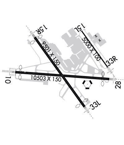 Airport Diagram might not be current. | |
| Facility Name: | BALTIMORE/WASHINGTON INTL THURGOOD MARSHALL |
| City Name: | BALTIMORE |
| County: | ANNE ARUNDEL |
| State abbrev: | MD |
| State Name: | MARYLAND |
| Ownership: | PUBLICLY OWNED |
| Use: | OPEN TO THE PUBLIC |
| Owner's Name: | STATE OF MARYLAND |
| Address: | PO BOX 8766 |
| BWI AIRPORT, MD 21240-0766 | |
| Owner's Phone: | 410-859-7100 |
| Manager's Name: | GREGORY SOLEK |
| Address: | AIRPORT OPERATIONS, PO BOX 8766 |
| BWI AIRPORT, MD 21240-0766 | |
| Phone: | 410-859-7018 |
| FAA Region: | EASTERN |
| FAA Field Office: | DCA |
| Date | Sunrise | Sunset |
|---|---|---|
| 06/08/26 Monday | 5:40 | 20:31 |
| 06/09/26 Tuesday | 5:40 | 20:32 |
| 06/10/26 Wednesday | 5:40 | 20:32 |
| 06/11/26 Thursday | 5:40 | 20:33 |
| 06/12/26 Friday | 5:40 | 20:33 |
| 06/13/26 Saturday | 5:40 | 20:34 |
| 06/14/26 Sunday | 5:40 | 20:34 |
| 06/15/26 Monday | 5:40 | 20:34 |
| 06/16/26 Tuesday | 5:40 | 20:35 |
| 06/17/26 Wednesday | 5:40 | 20:35 |
| 06/18/26 Thursday | 5:40 | 20:35 |
| 06/19/26 Friday | 5:40 | 20:36 |
| 06/20/26 Saturday | 5:40 | 20:36 |
| 06/21/26 Sunday | 5:41 | 20:36 |
| Airport Attendance Schedule | CONTINUOUS |
| Airport Status | OPERATIONAL (This Status can change at any time - please check NOTAMS) |
| Airport Lighting Schedule | |
| Airport Storage Available | Tie Downs, Hanger |
| Extra Services Available | Air Freight, Cargo Handling, Charter, Flight Instruction, Aircraft Rental, Aircraft Sales |
| Wind Indicator | YES - (lighted) |
| Control Tower | YES |
| CTAF Frequency | |
| Unicom Frequency | |
| Rotating Beacon Color | WG |
| Segmented Circle | YES |
| Landing Fee | YES |
| Airport Inspected | 5010-1 PUBLIC USE MAILOUT PROGRAM - performed by FAA AIRPORTS FIELD PERSONNEL |
| Inspection Date | 03/30/2026 |
| Type of Fuel Available | Grade 100LL, JET A (freeze point -40C) |
| Airframe Repair Service | MAJOR |
| Power Plant Repair Service | MAJOR |
| Latitude | N3910.5 |
| Longitude | W07640.1 (ESTIMATED; SURVEYED.) |
| Arpt Elevation | 143ft (SURVEYED) |
| Magnetic Variation | 11W |
| 9 miles S | of BALTIMORE |
| Traffic Pattern Altitude | |
| Sectional Chart | WASHINGTON |
| Operations (Reported) | Yearly | Avg. Daily |
|---|---|---|
| General Aviation Transient | 0 | 0 |
| General Aviation Local | 0 | 0 |
| Air Taxi | 0 | 0 |
| Commerical | 0 | 0 |
| Commuter | 0 | 0 |
| Military | 0 | 0 |
| Aircraft based on Field | |
|---|---|
| General Aviation Singles | 0 |
| General Aviation Multi | 0 |
| Jet Aircraft | 0 |
| General Aviation Helicopters | 0 |
| Military Aircraft | 0 |
| Gliders | 0 |
| Ultralights | 0 |
| FSS on field | NO |
| FSS tie-in | LEESBURG |
| FSS Phone | 1-800-WX-BRIEF |
| Who issues Notams | BWI |
| Notam D service at airport | YES |
| ARTCC Name | WASHINGTON |
| Airport Certification | AIRPORT RECEIVING SCHEDULED AIR CARRIER SERVICE FROM CARRIERS CERTIFICATED BY THE CIVIL AERONAUTICS BOARD |
| Aircraft Rescue & Firefighting Index | AIRPORT HAS A CERTIFICATE UNDER CFR PART 139 |
| Airport of Entry | No |
| Custom Landing Rights | YES |
| Joint Civil/Military | No |
| Military Landing rights | YES |
| NATIONAL PLAN OF INTEGRATED AIRPORT SYSTEMS (NPIAS) |
| GRANT AGREEMENTS UNDER FAAP/ADAP/AIP |
| ASSURANCES PURSUANT TO TITLE VI, CIVIL RIGHTS ACT OF 1964 |
| NOISE ABATEMENT PROCEDURES IN EFFECT - RSTRN FOR RWY 15L/33R EXCEPT FOR EMERG OR MERCY FLIGHTS CTC AMGR FOR INFO. |
| MAJOR CONSTR ON ARPT DLY; ACFT MOV & PRKG AREAS SUBJECT TO SHORT NOTICE CHANGE/CLOSURE. FOR CURRENT INFO PHONE BWI OPNS CNTR 410-859-7018. |
| ACFT ON VISUAL APCHS EXPECT TO MAINTAIN 3000 FT UNTIL 10 DME FM BAL VORTAC; DEP ACFT SHOULD EXPECT TURNS BASED ON BALTIMORE DME. |
| TAXIING PROHIBITED BTN CONCOURSE C & ADJ BLDG STRUCTURE SW OF CONCOURSE C. ACCESS TO GATE C12 MUST BE VIA TWY A. |
| TWY "S", SOUTH OF TWY "P", RSTRD TO ACFT 60000 LBS & LESS. |
| GA ACFT CTC 129.0 PRIOR TO ARR AT GA RAMP FOR SCTY PURPOSES. |
| PRACTICE LNDG & APCH BY TURBO-PWRD ACFT PROHIBITED 2200-0600; PRACTICE LNDG & TKOF BY B-747 ACFT PROHIBITED RWY 15R/33L. |
| TAXILANES 'T-1' & "H" RSTRD TO GROUP III ACFT WITH MAX WINGSPAN OF 118 FEET. |
| CONCOURSE A ALT DEICING AREA IS RSTRD TO B737-800 SIZE ACFT WITH WINGLETS OR SMLR ON SPOTS 6, 7 AND 8. |
| RWY 28 DE-ICE PAD LANE 1 RSTRD TO ACFT WITH WINGSPAN 171 FT OR LESS, LANE 2 RSTRD TO ACFT WITH WINGSPAN 135 FT OR LESS, LANE 3 IS USED BY LARGE ACFT MAX WINGSPAN 215 FT AND WHEN IN USE- LANES 2 AND 4 ARE UNAVBL. LANES 4, 5 & 6 ARE RSTRD TO ACFT WINGSPAN 135 FT OR LESS. |
| CONT MOWING OPERATIONS ADJ ALL RWYS & TWYS - APR THRU NOV. |
| TWY T BTN TWY H AND TWY E RSTD TO GROUP IV ACFT WITH WINGSPAN LESS THAN 171 FT. TWY T BTN TWY E AND TWY B RSTRD TO GROUP V ACFT WITH WINGSPAN LESS THAN 214 FT; WHEN GROUP V ACFT ARE ON TWY T, TWY A IS RSTRD TO MAX WINGSPANS OF 110 FT. |
| DUAL PARALLEL TAXILANES HAVE BEEN ADDED TO THE 'D'/'E' ALLEYWAY; TAXILANE 'N' AND TAXILANE 'N1'. TAXILANE 'N' IS DESIGNATED A "GROUP V" TAXILANE WITH MAX WINGSPAN OF 213 FT. TAXILANE 'N1' IS DESIGNATED A "GROUP IV" TAXILANE WITH MAX WINGSPAN OF 170 FT. |
| TWY 'A' IS RSTRD TO GROUP IV ACFT WINGSPAN 171 FT OR LESS. |
| RWY LEN AVBL FOR RWY 28 DEPS FM TWY U1 IS 9802 FT. |
| RWY STATUS LGTS IN OPN. |
| ACFT DEPARTING RWY 28 EXP DEP FM TWY U1. |
| DURING ATC ZERO EVENTS, UNICOM 119.4. |
| NO APRON PARKING FOR UNSKED ACR. |
| UNICOM 119.4. |
| RWY 15R DEICE PAD PSNS 1 THRU 5 RSTRD TO ACFT WITH WINGSPAN 117 FT 6 INS OR LESS. |
| DEER & BIRDS OCNLLY ON & INVOF ARPT. |
| DISTRACTING LGTS (GOLF DRIVING RANGE) RIGHT SIDE EXTDD CNTRLN RWY 33L FM AER TO 1/4 MI FINAL. |
| RWY 10/2 8 PCR VALUE: 759/F/A/X/T |
| RWY 15L/ 33RPCR VALUE: 269/F/A/X/T |
| RWY 15R/ 33LPCR VALUE: 759/F/A/X/T |
Airport Communications & Frequencies:
| |||||||||||||||||||||||||||||||||||||||||||||||||||||||||||||||||||||||||||||||||
| Runway: 10 | Runway: 28 | ||
| Mag heading: | 105° | Mag heading: | 285° |
| Rwy Slope: | -.12% Down | Rwy Slope: | .12% Up |
| Approach: | ILS | Approach: | ILS |
| Pattern: | Left Traffic | Pattern: | Left Traffic |
| Markings: | PRECISION INSTRUMENT | Markings: | PRECISION INSTRUMENT |
| Marking Condition: | GOOD | Marking Condition: | GOOD |
| Arresting Dev: | Arresting Dev: | ||
| Lat & Long: | N3910.5 W07641.4 | Lat. & Long.: | N3910.4 W07639.2 |
| Elev: | 139.0 ft. MSL | Elev: | 126.4 ft. MSL |
| TCH: | 71 ft. AGL | TCH: | 75 ft. AGL |
| Visual Glide Path: | 3.00 degrees | Visual Glide Path: | 3.00 degrees |
| Displaced Threshold: | 550 feet | Displaced Threshold: | 700 feet |
| Touchdown Zone: | YES | Touchdown Zone: | YES |
| Touchdown Elev.: | 143.4 feet | Touchdown Elev.: | 142.7 feet |
| Visual Glide Slope: | 4-Light PAPI on RIGHT side of Runway | Visual Glide Slope: | 4-Light PAPI on LEFT side of Runway |
| RVR Equipment: | TOUCHDOWN-MIDFIELD-ROLLOUT; MIDFIELD RVR SENSOR SHARED BY RWY 10/28 & RWY 15R/33L. | RVR Equipment: | TOUCHDOWN-MIDFIELD-ROLLOUT |
| RVV Equipment: | YES | RVV Equipment: | NO |
| Approach Lights: | ALSF2 - standard 2,400 foot high intensity approach lighting system with sequenced flashers, Category II or III | Approach Lights: | MALSR - 1,400 foot medium intensity approach lighting system with runway alignment indicator lights |
| REIL: | NO | REIL: | NO |
| Centerline Lights: | YES | Centerline Lights: | YES |
| Touchdown lights: | YES | Touchdown lights: | NO |
| Runway Category: | Precision Instrument Runway | Runway Category: | Precision Instrument Runway |
| Declared Distances: | TORA:10503' TODA:10503' ASDA:10503' LDA:9953' | Declared Distances: | TORA:10503' TODA:10503' ASDA:10503' LDA:9803' |
| Obstructions: | TREE | Obstructions: | TREE |
| Marked: | NOT Marked/Lighted | Marked: | NOT Marked/Lighted |
| Clearance slope: | 40:1; APCH RATIO 50:1 TO DSPLCD THR. | Clearance slope: | 33:1; APCH RATIO 50:1 TO DSPLCD THR. |
| Obstruction height: | 35 feet AGL | Obstruction height: | 31 feet AGL |
| Dist. from runway: | 1606 feet | Dist. from runway: | 1230 feet |
| Centerline offset: | 305 right of centerline | Centerline offset: | 425 feet right of centerline |
| Comments: | Comments: |
| Runway: 15L | Runway: 33R | ||
| Mag heading: | 155° | Mag heading: | 335° |
| Rwy Slope: | -.55% Down | Rwy Slope: | .55% Up |
| Approach: | ILS | Approach: | ILS |
| Pattern: | Left Traffic | Pattern: | Left Traffic |
| Markings: | PRECISION INSTRUMENT | Markings: | PRECISION INSTRUMENT |
| Marking Condition: | GOOD | Marking Condition: | GOOD |
| Arresting Dev: | Arresting Dev: | ||
| Lat & Long: | N3911.2 W07639.8 | Lat. & Long.: | N3910.6 W07639.2 |
| Elev: | 141.4 ft. MSL | Elev: | 114.0 ft. MSL |
| TCH: | 47 ft. AGL | TCH: | 47 ft. AGL |
| Visual Glide Path: | 3.00 degrees | Visual Glide Path: | 3.00 degrees |
| Displaced Threshold: | No | Displaced Threshold: | No |
| Touchdown Zone: | YES | Touchdown Zone: | YES |
| Touchdown Elev.: | 141.5 feet | Touchdown Elev.: | 124.4 feet |
| Visual Glide Slope: | 4-Light PAPI on LEFT side of Runway | Visual Glide Slope: | 4-Light PAPI on LEFT side of Runway |
| RVR Equipment: | TOUCHDOWN-ROLLOUT | RVR Equipment: | TOUCHDOWN-ROLLOUT |
| RVV Equipment: | NO | RVV Equipment: | NO |
| Approach Lights: | Approach Lights: | MALSR - 1,400 foot medium intensity approach lighting system with runway alignment indicator lights | |
| REIL: | YES | REIL: | YES |
| Centerline Lights: | NO | Centerline Lights: | NO |
| Touchdown lights: | NO | Touchdown lights: | NO |
| Runway Category: | Precision Instrument Runway | Runway Category: | Precision Instrument Runway |
| Declared Distances: | TORA:5000' TODA:5000' ASDA:5000' LDA:5000' | Declared Distances: | TORA:5000' TODA:5000' ASDA:5000' LDA:5000' |
| Obstructions: | POLE | Obstructions: | TREE |
| Marked: | NOT Marked/Lighted | Marked: | NOT Marked/Lighted |
| Clearance slope: | 30:1 | Clearance slope: | 32:1 |
| Obstruction height: | 31 feet AGL | Obstruction height: | 39 feet AGL |
| Dist. from runway: | 1120 feet | Dist. from runway: | 1470 feet |
| Centerline offset: | 615 right of centerline | Centerline offset: | 585 feet right of centerline |
| Comments: | Comments: |
| Runway: 15R | Runway: 33L | ||
| Mag heading: | 155° | Mag heading: | 335° |
| Rwy Slope: | -.10% Down | Rwy Slope: | .10% Up |
| Approach: | ILS | Approach: | ILS |
| Pattern: | Left Traffic | Pattern: | Left Traffic |
| Markings: | PRECISION INSTRUMENT | Markings: | PRECISION INSTRUMENT |
| Marking Condition: | GOOD | Marking Condition: | GOOD |
| Arresting Dev: | Arresting Dev: | ||
| Lat & Long: | N3911.1 W07640.9 | Lat. & Long.: | N3909.9 W07639.7 |
| Elev: | 139.0 ft. MSL | Elev: | 129.6 ft. MSL |
| TCH: | 73 ft. AGL | TCH: | 72 ft. AGL |
| Visual Glide Path: | 3.00 degrees | Visual Glide Path: | 3.00 degrees |
| Displaced Threshold: | 301 feet | Displaced Threshold: | 500 feet |
| Touchdown Zone: | YES | Touchdown Zone: | YES |
| Touchdown Elev.: | 138.3 feet | Touchdown Elev.: | 142.7 feet |
| Visual Glide Slope: | 4-Light PAPI on RIGHT side of Runway | Visual Glide Slope: | 4-Light PAPI on LEFT side of Runway |
| RVR Equipment: | TOUCHDOWN-MIDFIELD-ROLLOUT | RVR Equipment: | TOUCHDOWN-MIDFIELD-ROLLOUT |
| RVV Equipment: | YES | RVV Equipment: | NO |
| Approach Lights: | MALSR - 1,400 foot medium intensity approach lighting system with runway alignment indicator lights | Approach Lights: | MALSR - 1,400 foot medium intensity approach lighting system with runway alignment indicator lights |
| REIL: | NO | REIL: | NO |
| Centerline Lights: | YES | Centerline Lights: | YES |
| Touchdown lights: | NO | Touchdown lights: | YES |
| Runway Category: | Precision Instrument Runway | Runway Category: | Precision Instrument Runway |
| Declared Distances: | TORA:9501' TODA:9501' ASDA:8601' LDA:8301' | Declared Distances: | TORA:9501' TODA:9501' ASDA:8801' LDA:8301' |
| Obstructions: | ANT | Obstructions: | TOWER |
| Marked: | LIGHTED | Marked: | NOT Marked/Lighted |
| Clearance slope: | 35:1 | Clearance slope: | 47:1 |
| Obstruction height: | 126 feet AGL | Obstruction height: | 154 feet AGL |
| Dist. from runway: | 4724 feet | Dist. from runway: | 7460 feet |
| Centerline offset: | 908 left of centerline | Centerline offset: | 906 feet left of centerline |
| Comments: | Comments: | RWY 33L +2 FT ROAD 170 FT FROM RWY END 500 FT LEFT. |
Thanks for using FltPlan.com
all rights reserved © 1999-2026 by Flight Plan LLC