
| BROWNWOOD RGNL BROWNWOOD TX |
| |
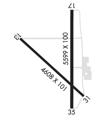
| Lat: N 3147.6 Long: W 09857.4 Elev: 1387 Var: -04 Longest Runway: 5599 | ||
| AWOS: 118.32 CTAF: 122.8 | ||
| ||||||
| ||||||
|
| Rwy | Rwy | |||||||
| 4608x101 | 4608' | 4608x101 | 4608' | |||||
| 5599x100 | 5599' | 109.10 - 175° | 5599x100 | 5599' | ||||
| Runway ID | Single Wheel | Double Wheel | Double Tandem Wheel | Dual Double Wheel |
| 13/31 | 25,000 | N/A | N/A | N/A |
| 17/35 | 30,000 | N/A | N/A | N/A |
| These numbers are Advisory and are not limits. The Airport Manager should have more accurate Weight Limits | ||||
 Airport Diagram might not be current. | |
| Facility Name: | BROWNWOOD RGNL |
| City Name: | BROWNWOOD |
| County: | BROWN |
| State abbrev: | TX |
| State Name: | TEXAS |
| Ownership: | PUBLICLY OWNED |
| Use: | OPEN TO THE PUBLIC |
| Owner's Name: | CITY OF BROWNWOOD |
| Address: | BOX 1389 |
| BROWNWOOD, TX 76801 | |
| Owner's Phone: | 325-646-5775 |
| Manager's Name: | KYLE WHITLEY |
| Address: | BOX 1389 |
| BROWNWOOD, TX 76801 | |
| Phone: | 325-643-1482 |
| FAA Region: | SOUTHWEST |
| FAA Field Office: | TEX |

| Date | Sunrise | Sunset |
|---|---|---|
| 06/12/26 Friday | 6:30 | 20:42 |
| 06/13/26 Saturday | 6:30 | 20:42 |
| 06/14/26 Sunday | 6:30 | 20:42 |
| 06/15/26 Monday | 6:30 | 20:43 |
| 06/16/26 Tuesday | 6:30 | 20:43 |
| 06/17/26 Wednesday | 6:30 | 20:43 |
| 06/18/26 Thursday | 6:30 | 20:44 |
| 06/19/26 Friday | 6:30 | 20:44 |
| 06/20/26 Saturday | 6:30 | 20:44 |
| 06/21/26 Sunday | 6:31 | 20:44 |
| 06/22/26 Monday | 6:31 | 20:45 |
| 06/23/26 Tuesday | 6:31 | 20:45 |
| 06/24/26 Wednesday | 6:31 | 20:45 |
| 06/25/26 Thursday | 6:32 | 20:45 |
| Airport Attendance Schedule | MON-FRI 0700-1700, SAT-SUN 0700-1500 |
| Airport Status | OPERATIONAL (This Status can change at any time - please check NOTAMS) |
| Airport Lighting Schedule | ACTVT MALS RWY 17; MIRL RWY 13/31 & 17/35 - CTAF. |
| Airport Storage Available | Tie Downs, Hanger |
| Extra Services Available | Air Freight, Cargo Handling, Flight Instruction |
| Wind Indicator | YES - (lighted) |
| Control Tower | NO |
| CTAF Frequency | 122.800 |
| Unicom Frequency | 122.800 |
| Rotating Beacon Color | WG |
| Segmented Circle | YES |
| Landing Fee | NO |
| Airport Inspected | STATE - performed by PRIVATE CONTRACT PERSONNEL |
| Inspection Date | 11/11/2023 |
| Type of Fuel Available | Grade 100LL, JET A (freeze point -40C); -10FUEL 24 HRS SELF SVC. FOR FUEL SVC WHEN UNATNDD CALL 325-643-1482. |
| Airframe Repair Service | MAJOR; REPAIRS 325-643-1482 |
| Power Plant Repair Service | MAJOR |
| Latitude | N3147.6 |
| Longitude | W09857.4 (ESTIMATED) |
| Arpt Elevation | 1386ft (SURVEYED) |
| Magnetic Variation | 04E |
| 5 miles N | of BROWNWOOD |
| Traffic Pattern Altitude | |
| Sectional Chart | SAN ANTONIO |
| Operations (Reported) | Yearly | Avg. Daily |
|---|---|---|
| General Aviation Transient | 0 | 0 |
| General Aviation Local | 0 | 0 |
| Air Taxi | 0 | 0 |
| Commerical | 0 | 0 |
| Commuter | 0 | 0 |
| Military | 0 | 0 |
| Aircraft based on Field | |
|---|---|
| General Aviation Singles | 0 |
| General Aviation Multi | 0 |
| Jet Aircraft | 0 |
| General Aviation Helicopters | 0 |
| Military Aircraft | 0 |
| Gliders | 0 |
| Ultralights | 0 |
| FSS on field | NO |
| FSS tie-in | FORT WORTH |
| FSS Phone | 1-800-WX-BRIEF |
| Who issues Notams | BWD |
| Notam D service at airport | YES |
| ARTCC Name | FORT WORTH |
| Airport Certification | |
| Aircraft Rescue & Firefighting Index | None |
| Airport of Entry | No |
| Custom Landing Rights | No |
| Joint Civil/Military | No |
| Military Landing rights | YES |
| NATIONAL PLAN OF INTEGRATED AIRPORT SYSTEMS (NPIAS) |
| GRANT AGREEMENTS UNDER FAAP/ADAP/AIP |
| SURPLUS PROPERTY AGREEMENT UNDER PUBLIC LAW 289 |
| ASSURANCES PURSUANT TO TITLE VI, CIVIL RIGHTS ACT OF 1964 |
| AGREEMENT UNDER DLAND OR DCLA HAS EXPIRED. |
| FOR CD IF UNA TO CTC ON FSS FREQ, CTC FORT WORTH ARTCC AT 817-858-7584. |
Airport Communications & Frequencies:
| |||||||||
| Runway: 13 | Runway: 31 | ||
| Mag heading: | 130° | Mag heading: | 310° |
| Rwy Slope: | -.19% Down | Rwy Slope: | .19% Up |
| Approach: | Approach: | ||
| Pattern: | Left Traffic | Pattern: | Left Traffic |
| Markings: | BASIC | Markings: | BASIC |
| Marking Condition: | GOOD | Marking Condition: | GOOD |
| Arresting Dev: | Arresting Dev: | ||
| Lat & Long: | N3147.8 W09857.8 | Lat. & Long.: | N3147.3 W09857.2 |
| Elev: | 1380.8 ft. MSL | Elev: | 1372.1 ft. MSL |
| TCH: | TCH: | ||
| Visual Glide Path: | Visual Glide Path: | ||
| Displaced Threshold: | No | Displaced Threshold: | No |
| Touchdown Zone: | YES | Touchdown Zone: | YES |
| Touchdown Elev.: | 1382.3 feet | Touchdown Elev.: | 1377.5 feet |
| Visual Glide Slope: | Visual Glide Slope: | ||
| RVR Equipment: | RVR Equipment: | ||
| RVV Equipment: | NO | RVV Equipment: | NO |
| Approach Lights: | Approach Lights: | ||
| REIL: | NO | REIL: | NO |
| Centerline Lights: | NO | Centerline Lights: | NO |
| Touchdown lights: | NO | Touchdown lights: | NO |
| Runway Category: | Runway with a Visual Approach | Runway Category: | Runway with a Visual Approach |
| Declared Distances: | Declared Distances: | ||
| Obstructions: | Obstructions: | TREES | |
| Marked: | Marked: | NOT Marked/Lighted | |
| Clearance slope: | 50:1 | Clearance slope: | 24:1 |
| Obstruction height: | Obstruction height: | 52 feet AGL | |
| Dist. from runway: | Dist. from runway: | 1450 feet | |
| Centerline offset: | Centerline offset: | 250 feet left of centerline | |
| Comments: | Comments: |
| Runway: 17 | Runway: 35 | ||
| Mag heading: | 175° | Mag heading: | 355° |
| Rwy Slope: | -.26% Down | Rwy Slope: | .26% Up |
| Approach: | LOCALIZER | Approach: | |
| Pattern: | Left Traffic | Pattern: | Left Traffic |
| Markings: | NONPRECISION INSTRUMENT | Markings: | NONPRECISION INSTRUMENT |
| Marking Condition: | GOOD | Marking Condition: | GOOD |
| Arresting Dev: | Arresting Dev: | ||
| Lat & Long: | N3148.1 W09857.3 | Lat. & Long.: | N3147.2 W09857.3 |
| Elev: | 1384.4 ft. MSL | Elev: | 1370.1 ft. MSL |
| TCH: | 55 ft. AGL | TCH: | 48 ft. AGL |
| Visual Glide Path: | 3.00 degrees | Visual Glide Path: | 3.00 degrees |
| Displaced Threshold: | No | Displaced Threshold: | No |
| Touchdown Zone: | YES | Touchdown Zone: | YES |
| Touchdown Elev.: | 1386.7 feet | Touchdown Elev.: | 1385.7 feet |
| Visual Glide Slope: | 4-Light PAPI on LEFT side of Runway | Visual Glide Slope: | 4-Light PAPI on LEFT side of Runway |
| RVR Equipment: | RVR Equipment: | ||
| RVV Equipment: | NO | RVV Equipment: | NO |
| Approach Lights: | MALS - 1,400 foot medium intensity approach lighting system | Approach Lights: | |
| REIL: | NO | REIL: | NO |
| Centerline Lights: | NO | Centerline Lights: | NO |
| Touchdown lights: | NO | Touchdown lights: | NO |
| Runway Category: | D | Runway Category: | Runway with a Non-precision Approach having visibility minimums greater than 3/4 mile |
| Declared Distances: | Declared Distances: | ||
| Obstructions: | TREES | Obstructions: | TREES |
| Marked: | NOT Marked/Lighted | Marked: | NOT Marked/Lighted |
| Clearance slope: | 29:1 | Clearance slope: | 33:1 |
| Obstruction height: | 33 feet AGL | Obstruction height: | 27 feet AGL |
| Dist. from runway: | 1185 feet | Dist. from runway: | 1100 feet |
| Centerline offset: | 290 left of centerline | Centerline offset: | |
| Comments: | Comments: |
Thanks for using FltPlan.com
all rights reserved © 1999-2026 by Flight Plan LLC