
| BEVERLY MUNI BEVERLY MA |
| |
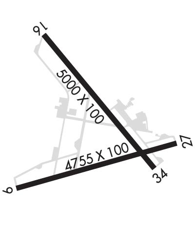
| Lat: N 4235.0 Long: W 07055.0 Elev: 107 Var: +16 Longest Runway: 5001 | ||
| Dept. ATIS: 119.2 Arr. ATIS: 119.2 Ground: 121.6 Tower: 125.2 | ||
| ||||||
| ||||||
|
| Rwy | Rwy | |||||||
| 4755x100 | 4755' | 4755x100 | 4505' | |||||
| 5001x100 | 4762' | 110.50 - 157° | 5001x100 | 5001' | ||||
| Runway ID | Single Wheel | Double Wheel | Double Tandem Wheel | Dual Double Wheel |
| 09/27 | 30,000 | 114,000 | 180,000 | N/A |
| 16/34 | 30,000 | 55,000 | 103,000 | N/A |
| These numbers are Advisory and are not limits. The Airport Manager should have more accurate Weight Limits | ||||
 Airport Diagram might not be current. | |
| Facility Name: | BEVERLY RGNL |
| City Name: | BEVERLY |
| County: | ESSEX |
| State abbrev: | MA |
| State Name: | MASSACHUSETTS |
| Ownership: | PUBLICLY OWNED |
| Use: | OPEN TO THE PUBLIC |
| Owner's Name: | CITY OF BEVERLY |
| Address: | CITY HALL, CABOT ST |
| BEVERLY, MA 01915 | |
| Owner's Phone: | 978-921-6000 |
| Manager's Name: | GLORIA BOUILLON |
| Address: | 50 L.P. HENDERSON ROAD |
| BEVERLY, MA 01915 | |
| Phone: | 978-921-6072 |
| FAA Region: | NEW ENGLAND |
| FAA Field Office: | NONE |
| Date | Sunrise | Sunset |
|---|---|---|
| 09/24/21 Friday | 6:33 | 18:38 |
| 09/25/21 Saturday | 6:34 | 18:36 |
| 09/26/21 Sunday | 6:35 | 18:34 |
| 09/27/21 Monday | 6:36 | 18:33 |
| 09/28/21 Tuesday | 6:37 | 18:31 |
| 09/29/21 Wednesday | 6:38 | 18:29 |
| 09/30/21 Thursday | 6:39 | 18:27 |
| 10/01/21 Friday | 6:40 | 18:26 |
| 10/02/21 Saturday | 6:42 | 18:24 |
| 10/03/21 Sunday | 6:43 | 18:22 |
| 10/04/21 Monday | 6:44 | 18:20 |
| 10/05/21 Tuesday | 6:45 | 18:19 |
| 10/06/21 Wednesday | 6:46 | 18:17 |
| 10/07/21 Thursday | 6:47 | 18:15 |
| Airport Attendance Schedule | 7 Days A Week 0830-1630 |
| Airport Status | OPERATIONAL (This Status can change at any time - please check NOTAMS) |
| Airport Lighting Schedule | WHEN TWR CLSD ACTVT MALS RWY 16; REIL RWY 34; PAPI RWY 16, 09, & 27; MIRL RWY 09/27 & 16/34 - CTAF. |
| Airport Storage Available | Tie Downs, Hanger |
| Extra Services Available | Avionics, Charter, Flight Instruction, Aircraft Rental, Aircraft Sales |
| Wind Indicator | YES - (unlit) |
| Control Tower | YES |
| CTAF Frequency | 125.200 |
| Unicom Frequency | 122.950 |
| Rotating Beacon Color | CLEAR-GREEN (Light Land Airport) |
| Segmented Circle | YES |
| Landing Fee |
| Airport Inspected | FEDERAL - performed by STATE AERONAUTICAL PERSONNEL |
| Inspection Date | 01/10/2020 |
| Type of Fuel Available | Grade 100LL, JET A (freeze point -40C); -10FUEL SVC 1030-2330Z++; AFT HRS REQ ONLY CALL 978-774-2070. |
| Airframe Repair Service | MAJOR |
| Power Plant Repair Service | MAJOR |
| Latitude | N4235.0 |
| Longitude | W07055.0 (ESTIMATED) |
| Arpt Elevation | 107ft (SURVEYED) |
| Magnetic Variation | 16W |
| 3 miles NW | of BEVERLY |
| Traffic Pattern Altitude | |
| Sectional Chart | NEW YORK |
| Operations (Reported) | Yearly | Avg. Daily |
|---|---|---|
| General Aviation Transient | 28799 | 79 |
| General Aviation Local | 35854 | 98 |
| Air Taxi | 1942 | 5 |
| Commerical | 0 | 0 |
| Commuter | 0 | 0 |
| Military | 121 | 0 |
| Aircraft based on Field | |
|---|---|
| General Aviation Singles | 84 |
| General Aviation Multi | 6 |
| Jet Aircraft | 3 |
| General Aviation Helicopters | 6 |
| Military Aircraft | 0 |
| Gliders | 0 |
| Ultralights | 1 |
| FSS on field | NO |
| FSS tie-in | BRIDGEPORT |
| FSS Phone | 1-800-WX-BRIEF |
| Who issues Notams | BVY |
| Notam D service at airport | YES |
| ARTCC Name | BOSTON |
| Airport Certification | |
| Aircraft Rescue & Firefighting Index | None |
| Airport of Entry | No |
| Custom Landing Rights | YES |
| Joint Civil/Military | No |
| Military Landing rights | YES |
| NATIONAL PLAN OF INTEGRATED AIRPORT SYSTEMS (NPIAS) |
| GRANT AGREEMENTS UNDER FAAP/ADAP/AIP |
| SURPLUS PROPERTY AGREEMENT UNDER PUBLIC LAW 289 |
| ASSURANCES PURSUANT TO TITLE VI, CIVIL RIGHTS ACT OF 1964 |
| AGREEMENT UNDER DLAND OR DCLA HAS EXPIRED. |
| PRKG - WEST SIDE TSNT RAMP AT FBO. |
| ALL ARR/DEP ACFT FLW MANUFACTURER'S RCMDD PROCS FOR QUIET OPNS & MNM NOISE. |
| BIRDS FQTLY ON OR INVOF ARPT; OCNL DEER OR COYOTE ON RWY. |
| TSNT ACFT MUST USE ANTI-THEFT DEVICE WHEN ACFT UNATDD. |
| NOISE SENSITIVE ARPT - VOLUNTARY COMPLIANCE REQD OF ALL ACFT EXCEEDING 75DB TO NOT LND/DEPART ARPT 2300-0700. |
| NO TIEDOWNS ROPES ON PUBLIC TSNT PRKG. |
| NOISE SENSITIVE AREA OFF THE DER 27 TO THE WEST, SW, AND SOUTH AND OFF THE DER 34 TO THE NW. |
| EAST RAMP TSNT SPACES: SPACES NO. 15, 16, 17 ONLY. |
| FUEL, PRKG CTC FBO 129.725 OR 978-774-2070. |
| WHEN TWR NOT OPN CLOSE FP WITH BOS APCH - 121.6. |
| RWY 16 IS THE PREF CALM WIND RWY. |
| RWY 09/27 AND RWY 16/34: DUE TO HUMP AT MIDPT, OPPOSITE ENDS OF THE RWY NOT VSB AT GROUND LEVEL. |
| LDG FEES FOR TSNT ACFT. |
| FLD COND NOT MNT 0200-1200Z++ 15 MAY-31 OCT; 0100-1200Z++ 01 NOV-14 MAY |
| NO ULTRALIGHT OR BANNER TOWING ALLOWED. |
| FUEL SVC 1030-2330Z++, AFTER HRS REQ ONLY ON 978-774-2070. |
| OVNGT PRKG FEE. |
| NOISE ABATEMENT PROCS IN EFCT CTC AMGR 978-921-6072. |
Airport Communications & Frequencies:
| ||||||||||||||||||||
| Runway: 09 | Runway: 27 | ||
| Mag heading: | 90° | Mag heading: | 270° |
| Rwy Slope: | .41% Up | Rwy Slope: | -.41% Down |
| Approach: | Approach: | ||
| Pattern: | Left Traffic | Pattern: | Left Traffic |
| Markings: | NONPRECISION INSTRUMENT | Markings: | NONPRECISION INSTRUMENT |
| Marking Condition: | GOOD | Marking Condition: | GOOD |
| Arresting Dev: | Arresting Dev: | ||
| Lat & Long: | N4234.8 W07055.5 | Lat. & Long.: | N4235.0 W07054.5 |
| Elev: | 71.6 ft. MSL | Elev: | 91.3 ft. MSL |
| TCH: | 43 ft. AGL | TCH: | 46 ft. AGL |
| Visual Glide Path: | 3.00 degrees | Visual Glide Path: | 3.22 degrees |
| Displaced Threshold: | No | Displaced Threshold: | 250 feet |
| Touchdown Zone: | YES | Touchdown Zone: | YES |
| Touchdown Elev.: | 85.8 feet | Touchdown Elev.: | 91.2 feet |
| Visual Glide Slope: | 4-Light PAPI on LEFT side of Runway | Visual Glide Slope: | 4-Light PAPI on LEFT side of Runway |
| RVR Equipment: | RVR Equipment: | ||
| RVV Equipment: | NO | RVV Equipment: | NO |
| Approach Lights: | Approach Lights: | ||
| REIL: | NO | REIL: | NO |
| Centerline Lights: | NO | Centerline Lights: | NO |
| Touchdown lights: | NO | Touchdown lights: | NO |
| Runway Category: | Runway with a Visual Approach | Runway Category: | Runway with a Non-precision Approach having visibility minimums greater than 3/4 mile |
| Declared Distances: | Declared Distances: | ||
| Obstructions: | TREE | Obstructions: | TREES |
| Marked: | NOT Marked/Lighted | Marked: | NOT Marked/Lighted |
| Clearance slope: | 6:1 | Clearance slope: | 8:1; RWY 27 50:1 TO DSPLCD THR. |
| Obstruction height: | 15 feet AGL | Obstruction height: | 22 feet AGL |
| Dist. from runway: | 300 feet | Dist. from runway: | 396 feet |
| Centerline offset: | 150 left of centerline | Centerline offset: | 125 feet right of centerline |
| Comments: | Comments: |
| Runway: 16 | Runway: 34 | ||
| Mag heading: | 157° | Mag heading: | 337° |
| Rwy Slope: | -.50% Down | Rwy Slope: | .50% Up |
| Approach: | LOC/DME | Approach: | |
| Pattern: | Left Traffic | Pattern: | Left Traffic |
| Markings: | NONPRECISION INSTRUMENT | Markings: | NONPRECISION INSTRUMENT |
| Marking Condition: | GOOD | Marking Condition: | GOOD |
| Arresting Dev: | Arresting Dev: | ||
| Lat & Long: | N4235.5 W07055.3 | Lat. & Long.: | N4234.9 W07054.6 |
| Elev: | 107.2 ft. MSL | Elev: | 82.1 ft. MSL |
| TCH: | 41 ft. AGL | TCH: | |
| Visual Glide Path: | 3.50 degrees | Visual Glide Path: | |
| Displaced Threshold: | 239 feet | Displaced Threshold: | No |
| Touchdown Zone: | YES | Touchdown Zone: | YES |
| Touchdown Elev.: | 107.3 feet | Touchdown Elev.: | 101.7 feet |
| Visual Glide Slope: | 4-Light PAPI on LEFT side of Runway | Visual Glide Slope: | |
| RVR Equipment: | RVR Equipment: | ||
| RVV Equipment: | NO | RVV Equipment: | NO |
| Approach Lights: | MALS - 1,400 foot medium intensity approach lighting system; RWY 16 NON-STD MALS - 800 FT. | Approach Lights: | |
| REIL: | NO | REIL: | YES |
| Centerline Lights: | NO | Centerline Lights: | NO |
| Touchdown lights: | NO | Touchdown lights: | NO |
| Runway Category: | Runway with a Non-precision Approach having visibility minimums greater than 3/4 mile | Runway Category: | Runway with a Non-precision Approach having visibility minimums greater than 3/4 mile |
| Declared Distances: | Declared Distances: | ||
| Obstructions: | TREES | Obstructions: | Unknown |
| Marked: | NOT Marked/Lighted | Marked: | NOT Marked/Lighted |
| Clearance slope: | 25:1; RWY 16 30:1 TO DSPLCD THR. | Clearance slope: | 20:1 |
| Obstruction height: | 32 feet AGL | Obstruction height: | 27 feet AGL |
| Dist. from runway: | 1000 feet | Dist. from runway: | 750 feet |
| Centerline offset: | 125 right of centerline | Centerline offset: | 75 feet left of centerline |
| Comments: | Comments: |
Thanks for using FltPlan.com
all rights reserved © 1999-2021 by Flight Plan LLC
