
| SKAGIT RGNL BURLINGTON/MT VERNON WA |
| |
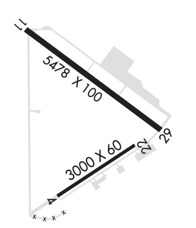
| Lat: N 4828.2 Long: W 12225.3 Elev: 145 Var: -16 Longest Runway: 5480 | ||
| AWOS: 121.12 CTAF: 123.07 | ||
| ||||||
| ||||||
|
| Rwy | Rwy | |||||||
| 3000x60 | 3000' | 3000x60 | 3000' | |||||
| 5480x100 | 5480' | 5480x100 | 5480' | |||||
| Runway ID | Single Wheel | Double Wheel | Double Tandem Wheel | Dual Double Wheel |
| 04/22 | 12,500 | N/A | N/A | N/A |
| 11/29 | 60,000 | 75,000 | 125,000 | N/A |
| These numbers are Advisory and are not limits. The Airport Manager should have more accurate Weight Limits | ||||
 Airport Diagram might not be current. | |
| Facility Name: | SKAGIT RGNL |
| City Name: | BURLINGTON/MOUNT VERNON |
| County: | SKAGIT |
| State abbrev: | WA |
| State Name: | WASHINGTON |
| Ownership: | PUBLICLY OWNED |
| Use: | OPEN TO THE PUBLIC |
| Owner's Name: | PORT OF SKAGIT COUNTY |
| Address: | 15400 AIRPORT DR, PO BOX 348 |
| BURLINGTON, WA 98233 | |
| Owner's Phone: | 360-757-0011 |
| Manager's Name: | KEITH D. LOVE |
| Address: | 15400 AIRPORT DR, 15400 AIRPORT DR |
| BURLINGTON, WA 98233 | |
| Phone: | 360-757-0011 |
| FAA Region: | NORTHWEST MOUNTAIN |
| FAA Field Office: | SEA |
| Date | Sunrise | Sunset |
|---|---|---|
| 09/24/21 Friday | 6:59 | 19:04 |
| 09/25/21 Saturday | 7:00 | 19:01 |
| 09/26/21 Sunday | 7:02 | 18:59 |
| 09/27/21 Monday | 7:03 | 18:57 |
| 09/28/21 Tuesday | 7:05 | 18:55 |
| 09/29/21 Wednesday | 7:06 | 18:53 |
| 09/30/21 Thursday | 7:07 | 18:51 |
| 10/01/21 Friday | 7:09 | 18:49 |
| 10/02/21 Saturday | 7:10 | 18:47 |
| 10/03/21 Sunday | 7:12 | 18:45 |
| 10/04/21 Monday | 7:13 | 18:43 |
| 10/05/21 Tuesday | 7:15 | 18:41 |
| 10/06/21 Wednesday | 7:16 | 18:39 |
| 10/07/21 Thursday | 7:18 | 18:37 |
| Airport Attendance Schedule | 7 Days A Week 0700-1900; TERMINAL BUILDING OPEN 0700-1900. AFTER HOURS, ACCESS AVAILABLE TO PILOTS. TERMINAL AND APRON ADJACENT TO TERMINAL FREE PILOT ACCESS WIFI. |
| Airport Status | OPERATIONAL (This Status can change at any time - please check NOTAMS) |
| Airport Lighting Schedule | ACTVT MIRL RY 11/29, LIRL RY 04/22, PAPI RY 11 & 29, AND REIL RY 11 & 29 - CTAF. PAPI RYS 04 & 22 OPR CONTINUOUSLY. |
| Airport Storage Available | Tie Downs |
| Extra Services Available | Air Freight, Avionics, Charter, Flight Instruction, Aircraft Rental, Aircraft Sales |
| Wind Indicator | YES - (lighted) |
| Control Tower | NO |
| CTAF Frequency | 123.075 |
| Unicom Frequency | 123.075 |
| Rotating Beacon Color | CLEAR-GREEN (Light Land Airport) |
| Segmented Circle | YES |
| Landing Fee | NO |
| Airport Inspected | STATE - performed by STATE AERONAUTICAL PERSONNEL |
| Inspection Date | 07/14/2020 |
| Type of Fuel Available | Grade 100LL, JET A (freeze point -40C) |
| Airframe Repair Service | MAJOR |
| Power Plant Repair Service | MAJOR |
| Latitude | N4828.2 |
| Longitude | W12225.3 (ESTIMATED) |
| Arpt Elevation | 145ft (SURVEYED) |
| Magnetic Variation | 16E |
| 3 miles W | of BURLINGTON/MOUNT VERNON |
| Traffic Pattern Altitude | 500; ULTRALIGHT TPA 500 FT AGL. |
| Sectional Chart | SEATTLE |
| Operations (Reported) | Yearly | Avg. Daily |
|---|---|---|
| General Aviation Transient | 35830 | 98 |
| General Aviation Local | 23970 | 66 |
| Air Taxi | 2000 | 5 |
| Commerical | 0 | 0 |
| Commuter | 0 | 0 |
| Military | 100 | 0 |
| Aircraft based on Field | |
|---|---|
| General Aviation Singles | 113 |
| General Aviation Multi | 8 |
| Jet Aircraft | 3 |
| General Aviation Helicopters | 7 |
| Military Aircraft | 0 |
| Gliders | 0 |
| Ultralights | 1 |
| FSS on field | NO |
| FSS tie-in | SEATTLE |
| FSS Phone | 1-800-WX-BRIEF |
| Who issues Notams | BVS |
| Notam D service at airport | YES |
| ARTCC Name | SEATTLE |
| Airport Certification | |
| Aircraft Rescue & Firefighting Index | None |
| Airport of Entry | No |
| Custom Landing Rights | No |
| Joint Civil/Military | No |
| Military Landing rights | YES |
| NATIONAL PLAN OF INTEGRATED AIRPORT SYSTEMS (NPIAS) |
| GRANT AGREEMENTS UNDER FAAP/ADAP/AIP |
| SURPLUS PROPERTY AGREEMENT UNDER PUBLIC LAW 289 |
| ASSURANCES PURSUANT TO TITLE VI, CIVIL RIGHTS ACT OF 1964 |
| FOR CD CTC WHIDBEY APCH AT 360-257-3310. |
| MIGRATORY WATERFOWL & BIRDS ON AND INVOF ARPT. |
| HELICOPTER TRAINING OPS ON AIRPORT W/ AUTOROTATIONS ON RUNWAY |
| USE OF TWY B BY ACFT WITH WINGSPAN 49 FT OR GREATER PROHIBITED WHEN RY 04/22 IN USE. |
| POSSIBLE TURBULENCE INVOF EXHAUST STACKS 3,500 FT SW OF RW 04, AVOID LOW ALT OVERFLT. |
| U.S. CUST SVC AVBL FOR INTL ARR. CHK PORT OF SKAGIT WEBSITE FOR REQ FOR SVC INSRT, WWW.PORTOFSKAGIT.COM. AVBL SEVEN DAYS A WEEK, PER APVL. USAGE FEES APPLY. |
| RWY 04/2 2 WDSPR, OPN, UNSEALED CRACKS AND JOINTS. |
Airport Communications & Frequencies:
| ||||||||||||||
| Runway: 04 | Runway: 22 | ||
| Mag heading: | 40° | Mag heading: | 220° |
| Rwy Slope: | .33% Up | Rwy Slope: | -.33% Down |
| Approach: | Approach: | ||
| Pattern: | Left Traffic | Pattern: | Left Traffic |
| Markings: | BASIC | Markings: | BASIC |
| Marking Condition: | POOR; MARKINGS FADED. | Marking Condition: | POOR; MARKINGS FADED. |
| Arresting Dev: | Arresting Dev: | ||
| Lat & Long: | N4827.8 W12225.6 | Lat. & Long.: | N4828.1 W12225.0 |
| Elev: | 84.0 ft. MSL | Elev: | 93.9 ft. MSL |
| TCH: | 43 ft. AGL | TCH: | 44 ft. AGL |
| Visual Glide Path: | 4.00 degrees | Visual Glide Path: | 3.00 degrees |
| Displaced Threshold: | No | Displaced Threshold: | No |
| Touchdown Zone: | YES | Touchdown Zone: | YES |
| Touchdown Elev.: | 93.9 feet | Touchdown Elev.: | 93.9 feet |
| Visual Glide Slope: | 2-Light PAPI on LEFT side of Runway | Visual Glide Slope: | 2-Light PAPI on LEFT side of Runway |
| RVR Equipment: | RVR Equipment: | ||
| RVV Equipment: | NO | RVV Equipment: | NO |
| Approach Lights: | Approach Lights: | ||
| REIL: | NO | REIL: | NO |
| Centerline Lights: | NO | Centerline Lights: | NO |
| Touchdown lights: | NO | Touchdown lights: | NO |
| Runway Category: | Runway with a Visual Approach | Runway Category: | Runway with a Visual Approach |
| Declared Distances: | Declared Distances: |
| Runway: 11 | Runway: 29 | ||
| Mag heading: | 110° | Mag heading: | 290° |
| Rwy Slope: | -.76% Down | Rwy Slope: | .76% Up |
| Approach: | Approach: | ||
| Pattern: | Left Traffic | Pattern: | Left Traffic |
| Markings: | NONPRECISION INSTRUMENT | Markings: | NONPRECISION INSTRUMENT |
| Marking Condition: | GOOD | Marking Condition: | GOOD |
| Arresting Dev: | Arresting Dev: | ||
| Lat & Long: | N4828.7 W12225.9 | Lat. & Long.: | N4828.1 W12224.8 |
| Elev: | 145.1 ft. MSL | Elev: | 103.2 ft. MSL |
| TCH: | 43 ft. AGL | TCH: | 42 ft. AGL |
| Visual Glide Path: | 3.00 degrees | Visual Glide Path: | 3.00 degrees |
| Displaced Threshold: | No | Displaced Threshold: | No |
| Touchdown Zone: | YES | Touchdown Zone: | YES |
| Touchdown Elev.: | 145.1 feet | Touchdown Elev.: | 126.9 feet |
| Visual Glide Slope: | 4-Light PAPI on LEFT side of Runway | Visual Glide Slope: | 4-Light PAPI on LEFT side of Runway |
| RVR Equipment: | RVR Equipment: | ||
| RVV Equipment: | NO | RVV Equipment: | NO |
| Approach Lights: | Approach Lights: | ||
| REIL: | YES | REIL: | YES |
| Centerline Lights: | NO | Centerline Lights: | NO |
| Touchdown lights: | NO | Touchdown lights: | NO |
| Runway Category: | Runway with a Non-precision Approach having visibility minimums greater than 3/4 mile | Runway Category: | Runway with a Non-precision Approach having visibility minimums greater than 3/4 mile |
| Declared Distances: | Declared Distances: |
Thanks for using FltPlan.com
all rights reserved © 1999-2021 by Flight Plan LLC
