| BURLINGTON INTL BURLINGTON VT |
| |
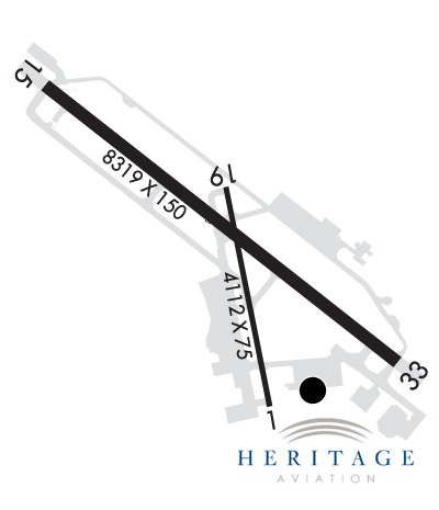
| Lat: N 4428.3 Long: W 07309.2 Elev: 335 Var: +15 Longest Runway: 8319 | ||
| Clr Del: 119.15 Dept. ATIS: 123.8 Arr. ATIS: 123.8 AWOS: 123.8 Ground: 126.3 Tower: 118.3 | ||
| |||||||||||||||||||||||||||||||||||||||||||||||||||||||||||||||||||||
| |||||||||||||||||||||||||||||||||||||||||||||||||||||||||||||||||||||
| |||||||||||||||||||||||||||||||||||||||||||||||||||||||||||||||||||||
| Rwy | Rwy | |||||||
| 4112x75 | 3887' | 4112x75 | 3612' | |||||
| 8319x150 | 8319' | 110.30 - 145° | 8319x150 | 7819' | 110.30 - 326° | |||
| Runway ID | Single Wheel | Double Wheel | Double Tandem Wheel | Dual Double Wheel |
| 01/19 | 30,000 | 40,000 | 60,000 | N/A |
| 15/33 | 100,000 | 175,000 | 355,000 | N/A |
| These numbers are Advisory and are not limits. The Airport Manager should have more accurate Weight Limits | ||||
 Airport Diagram might not be current. | |
| Facility Name: | BURLINGTON INTL |
| City Name: | BURLINGTON |
| County: | CHITTENDEN |
| State abbrev: | VT |
| State Name: | VERMONT |
| Ownership: | PUBLICLY OWNED |
| Use: | OPEN TO THE PUBLIC |
| Owner's Name: | CITY OF BURLINGTON |
| Address: | CITY HALL |
| BURLINGTON, VT 05401 | |
| Owner's Phone: | 802-865-7272 |
| Manager's Name: | EUGENE RICHARDS III |
| Address: | 1200 ARPT DR NO 1 |
| SOUTH BURLINGTON, VT 05403 | |
| Phone: | 802-863-2874 |
| FAA Region: | NEW ENGLAND |
| FAA Field Office: | NONE |
| Date | Sunrise | Sunset |
|---|---|---|
| 09/24/21 Friday | 6:42 | 18:47 |
| 09/25/21 Saturday | 6:43 | 18:45 |
| 09/26/21 Sunday | 6:44 | 18:43 |
| 09/27/21 Monday | 6:45 | 18:41 |
| 09/28/21 Tuesday | 6:46 | 18:39 |
| 09/29/21 Wednesday | 6:48 | 18:37 |
| 09/30/21 Thursday | 6:49 | 18:36 |
| 10/01/21 Friday | 6:50 | 18:34 |
| 10/02/21 Saturday | 6:51 | 18:32 |
| 10/03/21 Sunday | 6:53 | 18:30 |
| 10/04/21 Monday | 6:54 | 18:28 |
| 10/05/21 Tuesday | 6:55 | 18:26 |
| 10/06/21 Wednesday | 6:56 | 18:25 |
| 10/07/21 Thursday | 6:57 | 18:23 |
| Airport Attendance Schedule | CONTINUOUS |
| Airport Status | OPERATIONAL (This Status can change at any time - please check NOTAMS) |
| Airport Lighting Schedule | DUSK-DAWN. ACTVT MALSR RWY 15; MALSF RWY 33; PAPI RWY 01 & 15; MIRL RWY 01/19; HIRL RWY 15/33; ALL TWYS - CTAF. PAPI RWY 19 & 33 OPR CONSLY. |
| Airport Storage Available | Tie Downs, Hanger |
| Extra Services Available | Air Freight, Air Ambulance, Avionics, Cargo Handling, Charter, Flight Instruction, Aircraft Rental |
| Wind Indicator | YES - (lighted) |
| Control Tower | YES |
| CTAF Frequency | 118.300 |
| Unicom Frequency | 122.950 |
| Rotating Beacon Color | CLEAR-GREEN (Light Land Airport) |
| Segmented Circle | NO |
| Landing Fee | YES; FEE FOR ITNRNT ACFT GTR THAN 6000 LBS. |
| Airport Inspected | FEDERAL - performed by FAA AIRPORTS FIELD PERSONNEL |
| Inspection Date | 07/21/2021 |
| Type of Fuel Available | Grade 100LL, JET A (freeze point -40C) |
| Airframe Repair Service | MAJOR |
| Power Plant Repair Service | MAJOR |
| Latitude | N4428.3 |
| Longitude | W07309.2 (ESTIMATED) |
| Arpt Elevation | 334ft (SURVEYED) |
| Magnetic Variation | 15W |
| 3 miles E | of BURLINGTON |
| Traffic Pattern Altitude | |
| Sectional Chart | MONTREAL |
| Operations (Reported) | Yearly | Avg. Daily |
|---|---|---|
| General Aviation Transient | 26280 | 72 |
| General Aviation Local | 21385 | 59 |
| Air Taxi | 8083 | 22 |
| Commerical | 4934 | 14 |
| Commuter | 0 | 0 |
| Military | 3866 | 11 |
| Aircraft based on Field | |
|---|---|
| General Aviation Singles | 71 |
| General Aviation Multi | 10 |
| Jet Aircraft | 11 |
| General Aviation Helicopters | 5 |
| Military Aircraft | 10 |
| Gliders | 0 |
| Ultralights | 1 |
| FSS on field | NO |
| FSS tie-in | BURLINGTON |
| FSS Phone | 1-800-WX-BRIEF |
| Who issues Notams | BTV |
| Notam D service at airport | YES |
| ARTCC Name | BOSTON |
| Airport Certification | AIRPORT RECEIVING SCHEDULED AIR CARRIER SERVICE FROM CARRIERS CERTIFICATED BY THE CIVIL AERONAUTICS BOARD |
| Aircraft Rescue & Firefighting Index | AIRPORT HAS A CERTIFICATE UNDER CFR PART 139 |
| Airport of Entry | YES |
| Custom Landing Rights | YES |
| Joint Civil/Military | No |
| Military Landing rights | YES |
| NATIONAL PLAN OF INTEGRATED AIRPORT SYSTEMS (NPIAS) |
| GRANT AGREEMENTS UNDER FAAP/ADAP/AIP |
| ASSURANCES PURSUANT TO TITLE VI, CIVIL RIGHTS ACT OF 1964 |
| AGREEMENT UNDER DLAND OR DCLA HAS EXPIRED. |
| SURPLUS PROPERTY AGREEMENT UNDER PUBLIC LAW 289 |
| CTN: GENERATING PLANT 2 NM FROM AER 15 PRODUCES STEAM WHICH MAY OBSC VSBTY ON FNA. |
| TWY L CLSD TO ACFT OVR 60000 LBS. |
| ANG: NON-STD TWY LGTS ON TWY E. |
| TWYS D, E, F, N CLSD TO CIVILIAN OPS. |
| SERVICE-A-GEAR: TYPE H/BAK-12A(B) AER 33 LCTD 1000 FT FM DSPLCD THR. TYPE H/BAK 12A(B) CABLE RAISED BY TWR ON PILOT REQ ONLY. RWY 15 AND RWY 33 A-G HOUSINGS ARE NON-FRANGIBLE (26 IN ABV GRD LEVEL) LCTD 250 FT FM RWY CNTLN. |
| ACR RAMP NOT AVBL FOR PVT AND/OR CHTR ACFT. |
| ANG: OPR 1030-2100Z++ WKDAYS, EXC HOL, CLSD SAT-MON. PPR FOR FUEL/PRKG, CTC ANG OPS DSN 220-5213/5920/5267 C802-660-5213. ALL TSNT ACFT ENR ETHAN ALLEN TRNG SITE AND R-6501A MUST STOP AT AASF FOR RQRD SAFETY BRIEF. |
| TWY M AVBL FOR SEASONAL USE, CLSD DRG WINTER MONTHS. |
| FIGHTER ACFT: NO LOW APCHS. ALL OTHER MIL ACFT LTD TO TWO PRACTICE APCHS. DO NOT FLY OVER HOSPITAL APRXLY 1.5 NM WEST OF RWY 15 APCH END. |
| TWY A BTN TWY G & TWY C CLSD TO ACFT WINGSPAN MORE THAN 118 FT EXC 1 HR PPR 802-316-6014 DLY. |
| FBO CLSD 0200-0900 DLY, EXC 1 HR PPR 802-863-3626. |
| COLD TEMPERATURE AIRPORT. ALTITUDE CORRECTION REQUIRED AT OR BELOW -10C. |
| BIRDS & DEER ON AND INVOF ARPT. |
| ARFF AVBL 24 HRS. |
| ACFT TURN AROUND CLNCS ON TWY G SOUTH OF TWY J LTD TO ACFT DESIGN GROUP II OR SMLR. |
| CAUTION: PHASE II WILDLIFE ACTVY DURG MIGRATION, MAR-MAY & AUG15-NOV15. |
| TWYS D, E, F, N, ANG & RNG RAMPS HAVE UNCONTROLLED VEHICLES & ACFT. |
| FIGHTER ACFT RSTRD TO TKOF WINDOW OF 0830-2230 MON-SAT; 1200-2230 SUN. |
| RWY 01/1 9 SOUTH OF RWY 15/33 INTXN TO TWY C, SW 100 DTW 355; SOUTH OF TWY C INTXN TO SOUTH END OF RWY, SW 30 DW 60. |
Airport Communications & Frequencies:
| |||||||||||||||||||||||||||||||||||||||||||
| Runway: 01 | Runway: 19 | ||
| Mag heading: | 6° | Mag heading: | 186° |
| Rwy Slope: | -.17% Down | Rwy Slope: | .17% Up |
| Approach: | Approach: | ||
| Pattern: | Left Traffic | Pattern: | Left Traffic |
| Markings: | NONPRECISION INSTRUMENT | Markings: | BASIC |
| Marking Condition: | GOOD | Marking Condition: | GOOD |
| Arresting Dev: | Arresting Dev: | ||
| Lat & Long: | N4427.8 W07309.1 | Lat. & Long.: | N4428.5 W07309.2 |
| Elev: | 333.7 ft. MSL | Elev: | 326.8 ft. MSL |
| TCH: | 27 ft. AGL | TCH: | 47 ft. AGL |
| Visual Glide Path: | 4.00 degrees | Visual Glide Path: | 3.50 degrees |
| Displaced Threshold: | 225 feet | Displaced Threshold: | 500 feet |
| Touchdown Zone: | YES | Touchdown Zone: | YES |
| Touchdown Elev.: | 333.6 feet | Touchdown Elev.: | 333.6 feet |
| Visual Glide Slope: | 4-Light PAPI on RIGHT side of Runway | Visual Glide Slope: | 4-Light PAPI on RIGHT side of Runway |
| RVR Equipment: | RVR Equipment: | ||
| RVV Equipment: | NO | RVV Equipment: | NO |
| Approach Lights: | Approach Lights: | ||
| REIL: | NO | REIL: | NO |
| Centerline Lights: | NO | Centerline Lights: | NO |
| Touchdown lights: | NO | Touchdown lights: | NO |
| Runway Category: | Runway with a Non-precision Approach having visibility minimums greater than 3/4 mile | Runway Category: | Runway with a Visual Approach |
| Declared Distances: | TORA:3611' TODA:3611' ASDA:3611' LDA:3386' | Declared Distances: | TORA:4111' TODA:4111' ASDA:4111' LDA:3386' |
| Obstructions: | TREE | Obstructions: | |
| Marked: | NOT Marked/Lighted | Marked: | |
| Clearance slope: | 17:1; 20:1 TO DTHR. | Clearance slope: | 20:1 |
| Obstruction height: | 63 feet AGL | Obstruction height: | |
| Dist. from runway: | 1290 feet | Dist. from runway: | |
| Centerline offset: | 25 left of centerline | Centerline offset: | |
| Comments: | Comments: |
| Runway: 15 | Runway: 33 | ||
| Mag heading: | 146° | Mag heading: | 326° |
| Rwy Slope: | .35% Up | Rwy Slope: | -.35% Down |
| Approach: | ILS/DME | Approach: | ILS/DME |
| Pattern: | Left Traffic | Pattern: | Left Traffic |
| Markings: | PRECISION INSTRUMENT | Markings: | PRECISION INSTRUMENT |
| Marking Condition: | GOOD | Marking Condition: | GOOD |
| Arresting Dev: | MA-1A; TYPE H/BAK-12A (B) 1499 FT. | Arresting Dev: | BAK-12; TYPE H/BAK-12A (B) 1500 FT. |
| Lat & Long: | N4428.8 W07310.0 | Lat. & Long.: | N4427.9 W07308.5 |
| Elev: | 305.5 ft. MSL | Elev: | 334.6 ft. MSL |
| TCH: | 51 ft. AGL | TCH: | 53 ft. AGL |
| Visual Glide Path: | 3.00 degrees | Visual Glide Path: | 3.20 degrees |
| Displaced Threshold: | No | Displaced Threshold: | 500 feet |
| Touchdown Zone: | YES | Touchdown Zone: | YES |
| Touchdown Elev.: | 325.9 feet | Touchdown Elev.: | 334.3 feet |
| Visual Glide Slope: | 4-Light PAPI on RIGHT side of Runway | Visual Glide Slope: | 4-Light PAPI on RIGHT side of Runway |
| RVR Equipment: | TOUCHDOWN-ROLLOUT | RVR Equipment: | TOUCHDOWN-ROLLOUT |
| RVV Equipment: | NO | RVV Equipment: | NO |
| Approach Lights: | MALSR - 1,400 foot medium intensity approach lighting system with runway alignment indicator lights | Approach Lights: | MALSF - 1,400 foot medium intensity approach lighting system with sequenced flashers |
| REIL: | NO | REIL: | NO |
| Centerline Lights: | NO | Centerline Lights: | NO |
| Touchdown lights: | NO | Touchdown lights: | NO |
| Runway Category: | Precision Instrument Runway | Runway Category: | Precision Instrument Runway |
| Declared Distances: | TORA:7820' TODA:7820' ASDA:7820' LDA:7820' | Declared Distances: | TORA:8320' TODA:8320' ASDA:8320' LDA:7820' |
| Obstructions: | TREES | Obstructions: | TREES |
| Marked: | NOT Marked/Lighted | Marked: | NOT Marked/Lighted |
| Clearance slope: | 33:1 | Clearance slope: | 23:1; 30:1 TO DTHR. |
| Obstruction height: | 51 feet AGL | Obstruction height: | 75 feet AGL |
| Dist. from runway: | 1930 feet | Dist. from runway: | 1975 feet |
| Centerline offset: | 705 right of centerline | Centerline offset: | 800 feet left of centerline |
| Comments: | Comments: |
Thanks for using FltPlan.com
all rights reserved © 1999-2021 by Flight Plan LLC