| BATON ROUGE METROPOLITAN, RYAN BATON ROUGE LA |
| |
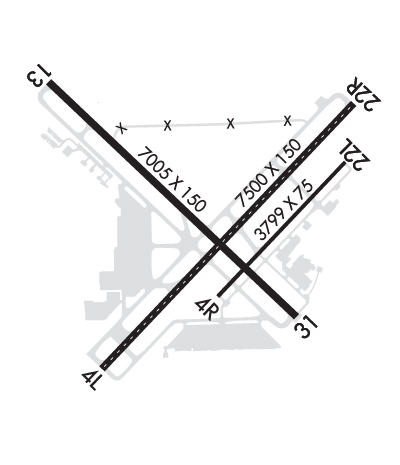
| Lat: N 3032.0 Long: W 09109.0 Elev: 70 Var: -00 Longest Runway: 7500 | ||
| Clr Del: 119.4 Dept. ATIS: 125.2 Arr. ATIS: 125.2 Ground: 121.9 Tower: 118.45 | ||
| ||||||||||||||||||||||||||||||||||||||||||||
| ||||||||||||||||||||||||||||||||||||||||||||
| ||||||||||||||||||||||||||||||||||||||||||||
| ||||||||||||||||||||||||||||||||||||||||||||
| FBOs at nearby airports who want your business: | |||||||||||||||||
| |||||||||||||||||
| Rwy | Rwy | |||||||
| 7500x150 | 7500' | 7500x150 | 7500' | 108.70 - 223° | ||||
| 3799x75 | 3799' | 3799x75 | 3799' | |||||
| 7005x150 | 6408' | 110.30 - 133° | 7005x150 | 6691' | ||||
| Runway ID | Single Wheel | Double Wheel | Double Tandem Wheel | Dual Double Wheel |
| 04L/22R | 120,000 | 170,000 | 300,000 | N/A |
| 04R/22L | 30,000 | 45,000 | N/A | N/A |
| 13/31 | 120,000 | 170,000 | 300,000 | N/A |
| These numbers are Advisory and are not limits. The Airport Manager should have more accurate Weight Limits | ||||
 Airport Diagram might not be current. | |
| Facility Name: | BATON ROUGE METRO, RYAN FLD |
| City Name: | BATON ROUGE |
| County: | EAST BATON ROUGE |
| State abbrev: | LA |
| State Name: | LOUISIANA |
| Ownership: | PUBLICLY OWNED |
| Use: | OPEN TO THE PUBLIC |
| Owner's Name: | EAST BATON ROUGE PARISH; CITY OF BATON ROUGE AND PARISH OF EAST BATON ROUGE. |
| Address: | PO BOX 1471 |
| BATON ROUGE, LA 70821 | |
| Owner's Phone: | |
| Manager's Name: | MIKE EDWARDS |
| Address: | 9430 JACKIE COCHRAN DR. STE 300 |
| BATON ROUGE, LA 70807 | |
| Phone: | 225-355-0333 |
| FAA Region: | SOUTHWEST |
| FAA Field Office: | LNM |

| Date | Sunrise | Sunset |
|---|---|---|
| 09/24/21 Friday | 6:54 | 18:59 |
| 09/25/21 Saturday | 6:54 | 18:58 |
| 09/26/21 Sunday | 6:55 | 18:56 |
| 09/27/21 Monday | 6:56 | 18:55 |
| 09/28/21 Tuesday | 6:56 | 18:54 |
| 09/29/21 Wednesday | 6:57 | 18:53 |
| 09/30/21 Thursday | 6:57 | 18:51 |
| 10/01/21 Friday | 6:58 | 18:50 |
| 10/02/21 Saturday | 6:59 | 18:49 |
| 10/03/21 Sunday | 6:59 | 18:48 |
| 10/04/21 Monday | 7:00 | 18:46 |
| 10/05/21 Tuesday | 7:00 | 18:45 |
| 10/06/21 Wednesday | 7:01 | 18:44 |
| 10/07/21 Thursday | 7:02 | 18:43 |
| Airport Attendance Schedule | 7 Days A Week 0500-0000 |
| Airport Status | OPERATIONAL (This Status can change at any time - please check NOTAMS) |
| Airport Lighting Schedule | ACTVT MALSR RYS 22R & 13, PAPI RY 04L AND MALS RY 31 - CTAF. WHEN ATCT CLSD HIRL RYS 13/31 & 04L/22R PRESET LOW INTST; TO INCR INTST ACTVT - CTAF. MIRL RY 04R/22L NOT AVBL. |
| Airport Storage Available | Tie Downs, Hanger |
| Extra Services Available | Air Freight, Avionics, Cargo Handling, Charter, Flight Instruction, Aircraft Rental, Aircraft Sales |
| Wind Indicator | YES - (lighted) |
| Control Tower | YES |
| CTAF Frequency | 118.450 |
| Unicom Frequency | 122.950 |
| Rotating Beacon Color | CLEAR-GREEN (Light Land Airport) |
| Segmented Circle | YES |
| Landing Fee | NO |
| Airport Inspected | FEDERAL - performed by FAA AIRPORTS FIELD PERSONNEL |
| Inspection Date | 10/20/2016 |
| Type of Fuel Available | Grade 100LL, JET A (freeze point -40C) |
| Airframe Repair Service | MAJOR |
| Power Plant Repair Service | MAJOR |
| Latitude | N3032.0 |
| Longitude | W09109.0 (ESTIMATED) |
| Arpt Elevation | 69ft (SURVEYED) |
| Magnetic Variation | 00E |
| 4 miles N | of BATON ROUGE |
| Traffic Pattern Altitude | |
| Sectional Chart | HOUSTON |
| Operations (Reported) | Yearly | Avg. Daily |
|---|---|---|
| General Aviation Transient | 29987 | 82 |
| General Aviation Local | 5126 | 14 |
| Air Taxi | 7288 | 20 |
| Commerical | 11908 | 33 |
| Commuter | 0 | 0 |
| Military | 1022 | 3 |
| Aircraft based on Field | |
|---|---|
| General Aviation Singles | 141 |
| General Aviation Multi | 44 |
| Jet Aircraft | 32 |
| General Aviation Helicopters | 23 |
| Military Aircraft | 0 |
| Gliders | 0 |
| Ultralights | 0 |
| FSS on field | NO |
| FSS tie-in | DE RIDDER |
| FSS Phone | 1-800-WX-BRIEF |
| Who issues Notams | BTR |
| Notam D service at airport | YES |
| ARTCC Name | HOUSTON |
| Airport Certification | AIRPORT RECEIVING SCHEDULED AIR CARRIER SERVICE FROM CARRIERS CERTIFICATED BY THE CIVIL AERONAUTICS BOARD; 24 HRS PPR FOR UNSKED ACR OPNS WITH MORE THAN 30 PSGR SEATS 0000-0500 CALL AMGR 225-355-2068/0333. |
| Aircraft Rescue & Firefighting Index | AIRPORT HAS A CERTIFICATE UNDER CFR PART 139 |
| Airport of Entry | No |
| Custom Landing Rights | YES |
| Joint Civil/Military | No |
| Military Landing rights | YES |
| NATIONAL PLAN OF INTEGRATED AIRPORT SYSTEMS (NPIAS) |
| GRANT AGREEMENTS UNDER FAAP/ADAP/AIP |
| SURPLUS PROPERTY AGREEMENT UNDER PUBLIC LAW 289 |
| ASSURANCES PURSUANT TO TITLE VI, CIVIL RIGHTS ACT OF 1964 |
| AGREEMENT UNDER DLAND OR DCLA HAS EXPIRED. |
| WHEN ATCT CLSD USE FREQ 121.9 TO CTC ARFF FOR EMERG REQ. |
| FOR CD IF UNA TO CTC ON FSS FREQ, CTC HOUSTON ARTCC AT 281-230-5622. |
| TWY E, TWY F BTN RWY 04R-22L AND AER 31 NOT AVBL FOR SKEDD ACR OPS. |
| TWY F BTN RWY 04R-22L AND AER 31 RDCS TO 40 FT WID. |
| MIGRATORY BIRDS ON & INVOF ARPT DURING MONTHS OF MAR/APR/SEP & OCT. |
| TWY M CLSD INDEFLY. |
| TWY E WEIGHT RESTRICTIONS: SINGLE 44,000 LBS; DUAL 55,000 LBS; DUAL TANDEM 93,000 LBS. |
| RAMP & TWY LANE ADJ TO THE COMMERICAL AIR CARRIER TERMINAL BLDG IS LMTD TO COMMERICAL AIR CARRIER AND PSGR AIRTAXI ACFT ONLY. |
| RWY 04R/22L NOT AVBL FOR ACR OPNS WITH MORE THAN 30 PSGR SEATS. |
| RWY 4R/22L AND TWY E ARE SIMILAR IN APPRNC. USE CTN WHEN EXITING RWY 13/31. |
| RWY 13 ARRESTING GEAR/SYSTEM: ENGINEERED MATERIALS ARRESTING SYSTEM (EMAS) 300 FT IN LENGTH BY 150 FT IN WIDTH LCTD AT THE DEPARTURE END OF RY 13. |
Airport Communications & Frequencies:
| |||||||||||||||||||||||||||||||||||||||||
| Runway: 04L | Runway: 22R | ||
| Mag heading: | 43° | Mag heading: | 223° |
| Rwy Slope: | .05% Up | Rwy Slope: | -.05% Down |
| Approach: | Approach: | ILS/DME | |
| Pattern: | Left Traffic | Pattern: | Right Traffic |
| Markings: | NONPRECISION INSTRUMENT | Markings: | PRECISION INSTRUMENT |
| Marking Condition: | GOOD | Marking Condition: | GOOD |
| Arresting Dev: | Arresting Dev: | ||
| Lat & Long: | N3031.5 W09109.4 | Lat. & Long.: | N3032.4 W09108.5 |
| Elev: | 65.4 ft. MSL | Elev: | 69.3 ft. MSL |
| TCH: | 55 ft. AGL | TCH: | 56 ft. AGL |
| Visual Glide Path: | 3.00 degrees | Visual Glide Path: | 3.00 degrees |
| Displaced Threshold: | No | Displaced Threshold: | No |
| Touchdown Zone: | YES | Touchdown Zone: | YES |
| Touchdown Elev.: | 68.9 feet | Touchdown Elev.: | 69.7 feet |
| Visual Glide Slope: | 4-Light PAPI on LEFT side of Runway | Visual Glide Slope: | 4-Light PAPI on LEFT side of Runway |
| RVR Equipment: | TOUCHDOWN-ROLLOUT | RVR Equipment: | TOUCHDOWN-ROLLOUT |
| RVV Equipment: | NO | RVV Equipment: | NO |
| Approach Lights: | Approach Lights: | MALSR - 1,400 foot medium intensity approach lighting system with runway alignment indicator lights | |
| REIL: | NO | REIL: | NO |
| Centerline Lights: | YES | Centerline Lights: | YES |
| Touchdown lights: | NO | Touchdown lights: | YES |
| Runway Category: | Runway with a Non-precision Approach having visibility minimums greater than 3/4 mile | Runway Category: | Precision Instrument Runway |
| Declared Distances: | TORA:7500' TODA:7500' ASDA:7500' LDA:7500' | Declared Distances: | TORA:7500' TODA:7500' ASDA:7500' LDA:7500' |
| Obstructions: | POLE | Obstructions: | TREES |
| Marked: | LIGHTED | Marked: | NOT Marked/Lighted |
| Clearance slope: | 38:1 | Clearance slope: | 16:1; +64 FT TREES 1598 FT 647 FT RIGHT, APCH RATIO 28:1 BASED ON DSPLCD THLD. |
| Obstruction height: | 52 feet AGL | Obstruction height: | 27 feet AGL |
| Dist. from runway: | 2200 feet | Dist. from runway: | 654 feet |
| Centerline offset: | 125 left of centerline | Centerline offset: | 404 feet left of centerline |
| Comments: | Comments: | 10 FT ROAD 200 FT 474 FT L APCH RATIO 0:1. |
| Runway: 04R | Runway: 22L | ||
| Mag heading: | 43° | Mag heading: | 223° |
| Rwy Slope: | .05% Up | Rwy Slope: | -.05% Down |
| Approach: | Approach: | ||
| Pattern: | Right Traffic | Pattern: | Left Traffic |
| Markings: | BASIC | Markings: | BASIC |
| Marking Condition: | GOOD | Marking Condition: | GOOD |
| Arresting Dev: | Arresting Dev: | ||
| Lat & Long: | N3031.7 W09109.0 | Lat. & Long.: | N3032.2 W09108.5 |
| Elev: | 66.5 ft. MSL | Elev: | 68.3 ft. MSL |
| TCH: | TCH: | ||
| Visual Glide Path: | 3.00 degrees | Visual Glide Path: | 3.00 degrees |
| Displaced Threshold: | No | Displaced Threshold: | No |
| Touchdown Zone: | YES | Touchdown Zone: | YES |
| Touchdown Elev.: | 68.9 feet | Touchdown Elev.: | 68.9 feet |
| Visual Glide Slope: | 2-Light PAPI on LEFT side of Runway | Visual Glide Slope: | 2-Light PAPI on LEFT side of Runway |
| RVR Equipment: | RVR Equipment: | ||
| RVV Equipment: | NO | RVV Equipment: | NO |
| Approach Lights: | Approach Lights: | ||
| REIL: | NO | REIL: | NO |
| Centerline Lights: | NO | Centerline Lights: | NO |
| Touchdown lights: | NO | Touchdown lights: | NO |
| Runway Category: | Runway with a Visual Approach | Runway Category: | Runway with a Visual Approach |
| Declared Distances: | TORA:3799' TODA:3799' ASDA:3799' LDA:3799' | Declared Distances: | TORA:3799' TODA:3799' ASDA:3799' LDA:3799' |
| Obstructions: | TREE | Obstructions: | TREE |
| Marked: | NOT Marked/Lighted | Marked: | NOT Marked/Lighted |
| Clearance slope: | 22:1 | Clearance slope: | 23:1 |
| Obstruction height: | 88 feet AGL | Obstruction height: | 27 feet AGL |
| Dist. from runway: | 2213 feet | Dist. from runway: | 842 feet |
| Centerline offset: | 277 right of centerline | Centerline offset: | 125 feet left of centerline |
| Comments: | Comments: |
| Runway: 13 | Runway: 31 | ||
| Mag heading: | 133° | Mag heading: | 313° |
| Rwy Slope: | .04% Up | Rwy Slope: | -.04% Down |
| Approach: | ILS/DME | Approach: | |
| Pattern: | Left Traffic | Pattern: | Left Traffic |
| Markings: | PRECISION INSTRUMENT | Markings: | NONPRECISION INSTRUMENT |
| Marking Condition: | GOOD | Marking Condition: | GOOD |
| Arresting Dev: | EMAS; ENGINEERED MATERIALS ARRESTING SYSTEM (EMAS) 300 FT IN LENGTH BY 150 FT IN WIDTH LCTD AT THE DEPARTURE END OF RY 13. | Arresting Dev: | |
| Lat & Long: | N3032.4 W09109.7 | Lat. & Long.: | N3031.6 W09108.7 |
| Elev: | 65.9 ft. MSL | Elev: | 69.0 ft. MSL |
| TCH: | TCH: | 64 ft. AGL | |
| Visual Glide Path: | Visual Glide Path: | 3.00 degrees | |
| Displaced Threshold: | 597 feet | Displaced Threshold: | 314 feet |
| Touchdown Zone: | YES | Touchdown Zone: | YES |
| Touchdown Elev.: | 66.8 feet | Touchdown Elev.: | 69.0 feet |
| Visual Glide Slope: | Visual Glide Slope: | 4-BOX VASI ON LEFT SIDE OF RUNWAY | |
| RVR Equipment: | TOUCHDOWN | RVR Equipment: | ROLLOUT |
| RVV Equipment: | NO | RVV Equipment: | NO |
| Approach Lights: | MALSR - 1,400 foot medium intensity approach lighting system with runway alignment indicator lights | Approach Lights: | MALS - 1,400 foot medium intensity approach lighting system |
| REIL: | NO | REIL: | NO |
| Centerline Lights: | NO | Centerline Lights: | NO |
| Touchdown lights: | NO | Touchdown lights: | NO |
| Runway Category: | Precision Instrument Runway | Runway Category: | D |
| Declared Distances: | TORA:7004' TODA:7004' ASDA:7004' LDA:6407' | Declared Distances: | TORA:7004' TODA:7004' ASDA:6407' LDA:6094' |
| Obstructions: | POLE | Obstructions: | ROAD |
| Marked: | LIGHTED | Marked: | NOT Marked/Lighted |
| Clearance slope: | 28:1 | Clearance slope: | 2:1; +68 FT TREE, 1578 FT, 516 RIGHT, APCH RATIO 24:1 BASED ON DSPLCD THLD. |
| Obstruction height: | 76 feet AGL | Obstruction height: | 11 feet AGL |
| Dist. from runway: | 2345 feet | Dist. from runway: | 230 feet |
| Centerline offset: | 103 right of centerline | Centerline offset: | 503 feet right of centerline |
| Comments: | +7 FT FENCE 200 FT 406 FT LEFT, APCH RATIO 0:1. | Comments: | +5 FT FENCE 200 FT 496 FT RIGHT, APCH RATIO 0:1. |
Thanks for using FltPlan.com
all rights reserved © 1999-2021 by Flight Plan LLC