
| W K KELLOGG BATTLE CREEK MI |
| |
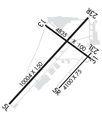
| Lat: N 4218.4 Long: W 08515.0 Elev: 952 Var: +04 Longest Runway: 10004 | ||
| Dept. ATIS: 128.32 Arr. ATIS: 128.32 Ground: 121.7 Tower: 126.82 | ||
| ||||||
| ||||||
| ||||||
|
| Rwy | Rwy | |||||||
| 10004x150 | 10004' | 10004x150 | 10004' | 110.50 - 227° | ||||
| 4100x75 | 4100' | 4100x75 | 4100' | |||||
| 4835x100 | 4835' | 4835x100 | 4835' | |||||
| Runway ID | Single Wheel | Double Wheel | Double Tandem Wheel | Dual Double Wheel |
| 05L/23R | 100,000 | 200,000 | 400,000 | 900,000 |
| 05R/23L | 12,500 | N/A | N/A | N/A |
| 13/31 | 40,000 | 65,000 | 100,000 | N/A |
| These numbers are Advisory and are not limits. The Airport Manager should have more accurate Weight Limits | ||||
 Airport Diagram might not be current. | |
| Facility Name: | BATTLE CREEK EXEC AT KELLOGG FLD |
| City Name: | BATTLE CREEK |
| County: | CALHOUN |
| State abbrev: | MI |
| State Name: | MICHIGAN |
| Ownership: | PUBLICLY OWNED |
| Use: | OPEN TO THE PUBLIC |
| Owner's Name: | CITY OF BATTLE CREEK |
| Address: | 15551 SOUTH AIRPORT RD |
| BATTLE CREEK, MI 49015-7644 | |
| Owner's Phone: | 269-966-3470 |
| Manager's Name: | LAWRENCE BOWRON |
| Address: | 15551 SOUTH AIRPORT RD |
| BATTLE CREEK, MI 49015-7644 | |
| Phone: | 269-966-3470 |
| FAA Region: | GREAT LAKES |
| FAA Field Office: | DET |
| Date | Sunrise | Sunset |
|---|---|---|
| 09/24/21 Friday | 7:30 | 19:35 |
| 09/25/21 Saturday | 7:31 | 19:33 |
| 09/26/21 Sunday | 7:32 | 19:32 |
| 09/27/21 Monday | 7:33 | 19:30 |
| 09/28/21 Tuesday | 7:35 | 19:28 |
| 09/29/21 Wednesday | 7:36 | 19:26 |
| 09/30/21 Thursday | 7:37 | 19:25 |
| 10/01/21 Friday | 7:38 | 19:23 |
| 10/02/21 Saturday | 7:39 | 19:21 |
| 10/03/21 Sunday | 7:40 | 19:19 |
| 10/04/21 Monday | 7:41 | 19:18 |
| 10/05/21 Tuesday | 7:42 | 19:16 |
| 10/06/21 Wednesday | 7:43 | 19:14 |
| 10/07/21 Thursday | 7:44 | 19:13 |
| Airport Attendance Schedule | CONTINUOUS |
| Airport Status | OPERATIONAL (This Status can change at any time - please check NOTAMS) |
| Airport Lighting Schedule | WHEN ATCT CLSD ACTVT MALSR RWY 23R; REIL RWY 05L, 05R, 23L, 13, & 31; PAPI RWY 05L, 23R, 05R, 23L, 13, & 31; HIRL RWY 05L/23R; MIRL RWY 05R/23L & 13/31 - CTAF. |
| Airport Storage Available | Tie Downs, Hanger |
| Extra Services Available | Air Freight, Avionics, Charter, Flight Instruction, Aircraft Rental, Aircraft Sales |
| Wind Indicator | YES - (lighted) |
| Control Tower | YES |
| CTAF Frequency | 126.825 |
| Unicom Frequency | 122.950 |
| Rotating Beacon Color | CLEAR-GREEN (Light Land Airport) |
| Segmented Circle | YES |
| Landing Fee | YES |
| Airport Inspected | FEDERAL - performed by FAA AIRPORTS FIELD PERSONNEL |
| Inspection Date | 11/30/2020 |
| Type of Fuel Available | Grade 100LL, JET A |
| Airframe Repair Service | MAJOR |
| Power Plant Repair Service | MAJOR |
| Latitude | N4218.4 |
| Longitude | W08515.0 (ESTIMATED) |
| Arpt Elevation | 951ft (SURVEYED) |
| Magnetic Variation | 04W |
| 3 miles W | of BATTLE CREEK |
| Traffic Pattern Altitude | |
| Sectional Chart | CHICAGO |
| Operations (Reported) | Yearly | Avg. Daily |
|---|---|---|
| General Aviation Transient | 30356 | 83 |
| General Aviation Local | 39384 | 108 |
| Air Taxi | 953 | 3 |
| Commerical | 15 | 0 |
| Commuter | 0 | 0 |
| Military | 717 | 2 |
| Aircraft based on Field | |
|---|---|
| General Aviation Singles | 74 |
| General Aviation Multi | 15 |
| Jet Aircraft | 1 |
| General Aviation Helicopters | 0 |
| Military Aircraft | 0 |
| Gliders | 0 |
| Ultralights | 0 |
| FSS on field | NO |
| FSS tie-in | LANSING |
| FSS Phone | 1-800-WX-BRIEF |
| Who issues Notams | BTL |
| Notam D service at airport | YES |
| ARTCC Name | CHICAGO |
| Airport Certification | CLSD TO SKEDD ACR OPS GTR THAN 9 PAX SEATS; 90 DAY PPR FOR UNSKED ACR OPS GTR THAN 30 PAX SEATS; INDEX C AVBL ON REQ - CALL AMGR. |
| Aircraft Rescue & Firefighting Index | AIRPORT HAS A CERTIFICATE UNDER CFR PART 139 |
| Airport of Entry | No |
| Custom Landing Rights | YES |
| Joint Civil/Military | No |
| Military Landing rights | YES |
| NATIONAL PLAN OF INTEGRATED AIRPORT SYSTEMS (NPIAS) |
| GRANT AGREEMENTS UNDER FAAP/ADAP/AIP |
| SURPLUS PROPERTY AGREEMENT UNDER PUBLIC LAW 289 |
| CONVEYANCE UNDER SCETION 16, FEDERAL AIRPORT ACT OF 1946 OR SECTION 23, AIRPORT AND AIRWAY DEVELOPMENT ACT OF 1970 |
| ASSURANCES PURSUANT TO TITLE VI, CIVIL RIGHTS ACT OF 1964 |
| DEER & BIRDS ON & INVOF ARPT. |
| MILITARY: ANG: BASH LEVELS AS DEFINED IN AFI 91-202. |
| MILITARY: ANG: APN/TWY USBL ONLY O/R, OTRW CLSD - COORD WITH 110TH WING SAFETY AT C269-969-3438. |
| EXTSV PILOT TRG WI 25 NM OF ARPT. |
| ARPT FICON MNTD WKDAYS 0700-1530; NOT MNTD ALL OTR TIMES. |
| SNOW REMOVAL OPS INPR DRG WINTER MONTHS; EQPT OPRS MNT CTAF WHEN ATCT CLSD. |
| 24 HRS PN FOR CUST, CALL 269-965-3349. |
| MOWING OPS INPR MAR-OCT. |
| FOR CD WHEN ATCT CLSD CTC GREAT LAKES APCH AT 269-459-3344, WHEN APCH CLSD CTC CHICAGO ARTCC AT 630-906-8921. |
| VOLUNTARY NOISE ABATEMENT PROCS IN EFCT. SEE FLY QUIET PROGRAM AT WWW.FLYBTL.COM. |
| TWY F RSTRD TO DOD/MIL USE ONLY. |
| RWY 05R/ 23LCLSD TO UNSKED ACR OPS GTR THAN 30 PAX SEATS. |
| RWY 13/3 1 CLSD TO UNSKED ACR OPS GTR THAN 30 PAX SEATS. |
Airport Communications & Frequencies:
| |||||||||||||||||||||||||
| Runway: 05L | Runway: 23R | ||
| Mag heading: | 47° | Mag heading: | 227° |
| Rwy Slope: | -.23% Down | Rwy Slope: | .23% Up |
| Approach: | Approach: | ILS | |
| Pattern: | Left Traffic | Pattern: | Left Traffic; RIGHT TFC WHEN TWR CLSD. |
| Markings: | NONPRECISION INSTRUMENT | Markings: | PRECISION INSTRUMENT |
| Marking Condition: | GOOD | Marking Condition: | GOOD |
| Arresting Dev: | Arresting Dev: | ||
| Lat & Long: | N4217.7 W08516.0 | Lat. & Long.: | N4219.0 W08514.5 |
| Elev: | 951.8 ft. MSL | Elev: | 928.4 ft. MSL |
| TCH: | 48 ft. AGL | TCH: | 49 ft. AGL |
| Visual Glide Path: | 3.00 degrees | Visual Glide Path: | 3.00 degrees |
| Displaced Threshold: | No | Displaced Threshold: | No |
| Touchdown Zone: | YES | Touchdown Zone: | YES |
| Touchdown Elev.: | 951.8 feet | Touchdown Elev.: | 928.8 feet |
| Visual Glide Slope: | 4-Light PAPI on LEFT side of Runway | Visual Glide Slope: | 4-Light PAPI on LEFT side of Runway |
| RVR Equipment: | ROLLOUT | RVR Equipment: | TOUCHDOWN |
| RVV Equipment: | NO | RVV Equipment: | YES |
| Approach Lights: | Approach Lights: | MALSR - 1,400 foot medium intensity approach lighting system with runway alignment indicator lights | |
| REIL: | YES | REIL: | NO |
| Centerline Lights: | NO | Centerline Lights: | NO |
| Touchdown lights: | NO | Touchdown lights: | NO |
| Runway Category: | Runway with a Non-precision Approach having visibility minimums greater than 3/4 mile | Runway Category: | Precision Instrument Runway |
| Declared Distances: | TORA:10004' TODA:10004' ASDA:10004' LDA:10004' | Declared Distances: | TORA:10004' TODA:10004' ASDA:10004' LDA:10004' |
| Obstructions: | Obstructions: | POLE | |
| Marked: | Marked: | LIGHTED | |
| Clearance slope: | 50:1 | Clearance slope: | 43:1 |
| Obstruction height: | Obstruction height: | 19 feet AGL | |
| Dist. from runway: | Dist. from runway: | 1033 feet | |
| Centerline offset: | Centerline offset: | 288 feet right of centerline | |
| Comments: | Comments: |
| Runway: 05R | Runway: 23L | ||
| Mag heading: | 47° | Mag heading: | 227° |
| Rwy Slope: | .12% Up | Rwy Slope: | -.12% Down |
| Approach: | Approach: | ||
| Pattern: | Left Traffic; RIGHT TFC WHEN TWR CLSD. | Pattern: | Left Traffic |
| Markings: | NONPRECISION INSTRUMENT | Markings: | NONPRECISION INSTRUMENT |
| Marking Condition: | GOOD | Marking Condition: | GOOD |
| Arresting Dev: | Arresting Dev: | ||
| Lat & Long: | N4218.0 W08515.0 | Lat. & Long.: | N4218.5 W08514.4 |
| Elev: | 925.0 ft. MSL | Elev: | 930.0 ft. MSL |
| TCH: | 25 ft. AGL | TCH: | 30 ft. AGL |
| Visual Glide Path: | 3.00 degrees | Visual Glide Path: | 3.00 degrees |
| Displaced Threshold: | No | Displaced Threshold: | No |
| Touchdown Zone: | YES | Touchdown Zone: | YES |
| Touchdown Elev.: | 926.9 feet | Touchdown Elev.: | 930.0 feet |
| Visual Glide Slope: | 4-Light PAPI on LEFT side of Runway | Visual Glide Slope: | 4-Light PAPI on LEFT side of Runway |
| RVR Equipment: | RVR Equipment: | ||
| RVV Equipment: | NO | RVV Equipment: | NO |
| Approach Lights: | Approach Lights: | ||
| REIL: | YES | REIL: | YES |
| Centerline Lights: | NO | Centerline Lights: | NO |
| Touchdown lights: | NO | Touchdown lights: | NO |
| Runway Category: | Runway with a Visual Approach | Runway Category: | Runway with a Visual Approach |
| Declared Distances: | TORA:4100' TODA:4100' ASDA:4100' LDA:4100' | Declared Distances: | TORA:4100' TODA:4100' ASDA:4100' LDA:4100' |
| Runway: 13 | Runway: 31 | ||
| Mag heading: | 130° | Mag heading: | 310° |
| Rwy Slope: | .20% Up | Rwy Slope: | -.20% Down |
| Approach: | Approach: | ||
| Pattern: | Left Traffic | Pattern: | Left Traffic |
| Markings: | NONPRECISION INSTRUMENT | Markings: | NONPRECISION INSTRUMENT |
| Marking Condition: | GOOD | Marking Condition: | GOOD |
| Arresting Dev: | Arresting Dev: | ||
| Lat & Long: | N4218.9 W08515.3 | Lat. & Long.: | N4218.4 W08514.4 |
| Elev: | 919.8 ft. MSL | Elev: | 929.4 ft. MSL |
| TCH: | 42 ft. AGL | TCH: | 25 ft. AGL |
| Visual Glide Path: | 3.00 degrees | Visual Glide Path: | 3.00 degrees |
| Displaced Threshold: | No | Displaced Threshold: | No |
| Touchdown Zone: | YES | Touchdown Zone: | YES |
| Touchdown Elev.: | 926.5 feet | Touchdown Elev.: | 930.1 feet |
| Visual Glide Slope: | 4-Light PAPI on LEFT side of Runway | Visual Glide Slope: | 4-Light PAPI on LEFT side of Runway |
| RVR Equipment: | RVR Equipment: | ||
| RVV Equipment: | NO | RVV Equipment: | NO |
| Approach Lights: | Approach Lights: | ||
| REIL: | YES | REIL: | YES |
| Centerline Lights: | NO | Centerline Lights: | NO |
| Touchdown lights: | NO | Touchdown lights: | NO |
| Runway Category: | Runway with a Visual Approach | Runway Category: | Runway with a Non-precision Approach having visibility minimums greater than 3/4 mile |
| Declared Distances: | TORA:4835' TODA:4835' ASDA:4835' LDA:4835' | Declared Distances: | TORA:4835' TODA:4835' ASDA:4835' LDA:4835' |
| Obstructions: | RR | Obstructions: | ROAD |
| Marked: | NOT Marked/Lighted | Marked: | NOT Marked/Lighted |
| Clearance slope: | 20:1 | Clearance slope: | 22:1 |
| Obstruction height: | 20 feet AGL | Obstruction height: | 15 feet AGL |
| Dist. from runway: | 601 feet | Dist. from runway: | 530 feet |
| Centerline offset: | 281 right of centerline | Centerline offset: | 6 feet right of centerline |
| Comments: | Comments: |
Thanks for using FltPlan.com
all rights reserved © 1999-2021 by Flight Plan LLC
