
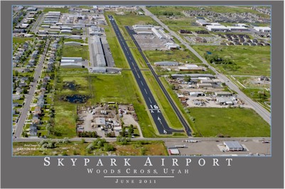
| SKYPARK BOUNTIFUL UT |
| |
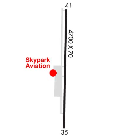
| Lat: N 4052.1 Long: W 11155.6 Elev: 4237 Var: -15 Longest Runway: 4634 | ||
| Clr Del: 120.7 CTAF: 122.8 | ||
| ||||||||||||||||||||||||||||||||
| ||||||||||||||||||||||||||||||||
| Rwy | Rwy | |||||||
| 4634x70 | 4245' | 4634x70 | 4243' | |||||
| Runway ID | Single Wheel | Double Wheel | Double Tandem Wheel | Dual Double Wheel |
| 17/35 | 12,500 | N/A | N/A | N/A |
| These numbers are Advisory and are not limits. The Airport Manager should have more accurate Weight Limits | ||||
| FltPlan does not have IFR approach charts available for KBTF. |
 Airport Diagram might not be current. | |
| Facility Name: | SKYPARK |
| City Name: | BOUNTIFUL |
| County: | DAVIS |
| State abbrev: | UT |
| State Name: | UTAH |
| Ownership: | PRIVATELY OWNED |
| Use: | OPEN TO THE PUBLIC |
| Owner's Name: | SKYPARK AIRPORT ASSOC, LLC |
| Address: | 1887 S. 1800 W. #2 |
| WOODS CROSS, UT 84087 | |
| Owner's Phone: | 801-295-3877 |
| Manager's Name: | CHRIS VOLZER |
| Address: | 1887 S. 1800 W., #2 |
| WOODS CROSS, UT 84087 | |
| Phone: | 801-295-3877 |
| FAA Region: | NORTHWEST MOUNTAIN |
| FAA Field Office: | DEN |
| Date | Sunrise | Sunset |
|---|---|---|
| 06/08/26 Monday | 5:56 | 20:58 |
| 06/09/26 Tuesday | 5:56 | 20:58 |
| 06/10/26 Wednesday | 5:56 | 20:59 |
| 06/11/26 Thursday | 5:56 | 20:59 |
| 06/12/26 Friday | 5:55 | 21:00 |
| 06/13/26 Saturday | 5:55 | 21:00 |
| 06/14/26 Sunday | 5:55 | 21:01 |
| 06/15/26 Monday | 5:55 | 21:01 |
| 06/16/26 Tuesday | 5:55 | 21:01 |
| 06/17/26 Wednesday | 5:55 | 21:02 |
| 06/18/26 Thursday | 5:56 | 21:02 |
| 06/19/26 Friday | 5:56 | 21:02 |
| 06/20/26 Saturday | 5:56 | 21:03 |
| 06/21/26 Sunday | 5:56 | 21:03 |
| Airport Attendance Schedule | MON-FRI 0700-1900, SAT-SUN 0800-1700 |
| Airport Status | OPERATIONAL (This Status can change at any time - please check NOTAMS) |
| Airport Lighting Schedule | ACTVT LIRL RWY 17/35 - CTAF. |
| Airport Storage Available | Tie Downs, Hanger |
| Extra Services Available | Avionics, Flight Instruction, Aircraft Rental |
| Wind Indicator | YES - (lighted) |
| Control Tower | NO |
| CTAF Frequency | 122.800 |
| Unicom Frequency | 122.800 |
| Rotating Beacon Color | WG |
| Segmented Circle | NO |
| Landing Fee | YES; FOR LNDG FEES, CTC AMGR. |
| Airport Inspected | STATE - performed by PRIVATE CONTRACT PERSONNEL |
| Inspection Date | 09/20/2023 |
| Type of Fuel Available | Grade 100LL, JET A (freeze point -40C)MOGAS; -10100LL & JET A SELF SVC FUEL AVBL 24 HRS WITH CC. |
| Airframe Repair Service | MAJOR |
| Power Plant Repair Service | MAJOR |
| Latitude | N4052.1 |
| Longitude | W11155.6 (ESTIMATED) |
| Arpt Elevation | 4237ft (SURVEYED) |
| Magnetic Variation | 15E |
| 3 miles SW | of BOUNTIFUL |
| Traffic Pattern Altitude | STD HELI TPA 1000 FT AGL. HELI TPA AMDD TO AGREE WITH ALL ACFT AT 1000 FT AGL. |
| Sectional Chart | SALT LAKE CITY |
| Operations (Reported) | Yearly | Avg. Daily |
|---|---|---|
| General Aviation Transient | 0 | 0 |
| General Aviation Local | 0 | 0 |
| Air Taxi | 0 | 0 |
| Commerical | 0 | 0 |
| Commuter | 0 | 0 |
| Military | 0 | 0 |
| Aircraft based on Field | |
|---|---|
| General Aviation Singles | 0 |
| General Aviation Multi | 0 |
| Jet Aircraft | 0 |
| General Aviation Helicopters | 0 |
| Military Aircraft | 0 |
| Gliders | 0 |
| Ultralights | 0 |
| FSS on field | NO |
| FSS tie-in | CEDAR CITY |
| FSS Phone | 1-800-WX-BRIEF |
| Who issues Notams | CDC |
| Notam D service at airport | YES |
| ARTCC Name | SALT LAKE CITY |
| Airport Certification | |
| Aircraft Rescue & Firefighting Index | None |
| Airport of Entry | No |
| Custom Landing Rights | No |
| Joint Civil/Military | No |
| Military Landing rights | YES |
| FOR CD CTC SALT LAKE CITY APCH AT 801-325-9670. |
| RWY 17/3 5 ALL DEPS WILL BE TO THE EAST. |
Airport Communications & Frequencies:
| |||||||||||
| Runway: 17 | Runway: 35 | ||
| Mag heading: | N/A | Mag heading: | N/A |
| Rwy Slope: | .02% Up | Rwy Slope: | -.02% Down |
| Approach: | Approach: | ||
| Pattern: | Left Traffic | Pattern: | Right Traffic |
| Markings: | BASIC | Markings: | BASIC |
| Marking Condition: | GOOD | Marking Condition: | GOOD |
| Arresting Dev: | Arresting Dev: | ||
| Lat & Long: | N4052.5 W11155.7 | Lat. & Long.: | N4051.7 W11155.6 |
| Elev: | 4236.1 ft. MSL | Elev: | 4237.1 ft. MSL |
| TCH: | 42 ft. AGL | TCH: | 42 ft. AGL |
| Visual Glide Path: | 3.50 degrees | Visual Glide Path: | 3.50 degrees |
| Displaced Threshold: | 389 feet | Displaced Threshold: | 391 feet |
| Touchdown Zone: | NO | Touchdown Zone: | NO |
| Touchdown Elev.: | Touchdown Elev.: | ||
| Visual Glide Slope: | 2-Light PAPI on LEFT side of Runway | Visual Glide Slope: | 2-Light PAPI on LEFT side of Runway |
| RVR Equipment: | RVR Equipment: | ||
| RVV Equipment: | NO | RVV Equipment: | NO |
| Approach Lights: | Approach Lights: | ||
| REIL: | NO | REIL: | NO |
| Centerline Lights: | NO | Centerline Lights: | NO |
| Touchdown lights: | NO | Touchdown lights: | NO |
| Runway Category: | Runway with a Visual Approach | Runway Category: | Runway with a Visual Approach |
| Declared Distances: | Declared Distances: | ||
| Obstructions: | FENCE | Obstructions: | FENCE |
| Marked: | NOT Marked/Lighted | Marked: | NOT Marked/Lighted |
| Clearance slope: | 4:1; APCH SLP 11:1 TO DTHR OVR 8 FT BLDG, 90 FT DSTC, 128 FT LEFT. | Clearance slope: | CTLG OBSTN EXCEEDS A 45 DEG SLP. |
| Obstruction height: | 8 feet AGL | Obstruction height: | 6 feet AGL |
| Dist. from runway: | 232 feet | Dist. from runway: | 200 feet |
| Centerline offset: | Centerline offset: | 90 feet left of centerline | |
| Comments: | 8 FT BLDG, 0 FT DSTC, 122 FT LEFT. | Comments: | 6 FT FENCE, 0-200 FT DSTC, 94 FT RIGHT. |
Thanks for using FltPlan.com
all rights reserved © 1999-2026 by Flight Plan LLC