
| BELFAST MUNI BELFAST ME |
| |
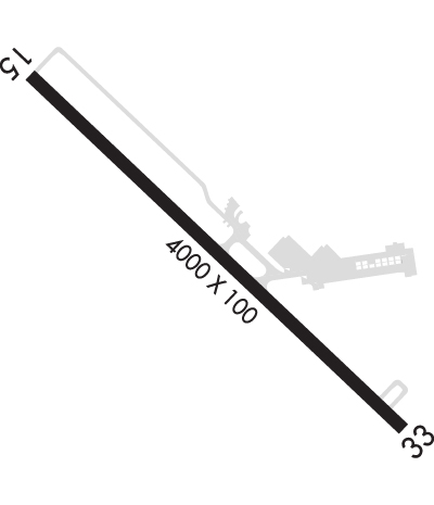
| Lat: N 4424.6 Long: W 06900.7 Elev: 198 Var: +18 Longest Runway: 4000 | ||
| AWOS: 122.97 CTAF: 122.97 | ||
| ||||||||||||||||||||||||||||||||||||||||||||
| ||||||||||||||||||||||||||||||||||||||||||||
| ||||||||||||||||||||||||||||||||||||||||||||
| Rwy | Rwy | |||||||
| 4000x100 | 4000' | 4000x100 | 4000' | |||||
| Runway ID | Single Wheel | Double Wheel | Double Tandem Wheel | Dual Double Wheel |
| 15/33 | 30,000 | N/A | N/A | N/A |
| These numbers are Advisory and are not limits. The Airport Manager should have more accurate Weight Limits | ||||
 Airport Diagram might not be current. | |
| Facility Name: | BELFAST MUNI |
| City Name: | BELFAST |
| County: | WALDO |
| State abbrev: | ME |
| State Name: | MAINE |
| Ownership: | PUBLICLY OWNED |
| Use: | OPEN TO THE PUBLIC |
| Owner's Name: | CITY OF BELFAST |
| Address: | CITY HALL 131 CHURCH ST (TOP FLOOR) |
| BELFAST, ME 04915 | |
| Owner's Phone: | 207-338-3370X600 |
| Manager's Name: | KENN ORTMANN |
| Address: | 22 WRIGHT BROTHERS DR. |
| BELFAST, ME 04915 | |
| Phone: | 603-970-1947 |
| FAA Region: | NEW ENGLAND |
| FAA Field Office: | NONE |
| Date | Sunrise | Sunset |
|---|---|---|
| 09/24/21 Friday | 6:25 | 18:30 |
| 09/25/21 Saturday | 6:26 | 18:28 |
| 09/26/21 Sunday | 6:28 | 18:27 |
| 09/27/21 Monday | 6:29 | 18:25 |
| 09/28/21 Tuesday | 6:30 | 18:23 |
| 09/29/21 Wednesday | 6:31 | 18:21 |
| 09/30/21 Thursday | 6:32 | 18:19 |
| 10/01/21 Friday | 6:33 | 18:17 |
| 10/02/21 Saturday | 6:35 | 18:15 |
| 10/03/21 Sunday | 6:36 | 18:14 |
| 10/04/21 Monday | 6:37 | 18:12 |
| 10/05/21 Tuesday | 6:38 | 18:10 |
| 10/06/21 Wednesday | 6:40 | 18:08 |
| 10/07/21 Thursday | 6:41 | 18:06 |
| Airport Attendance Schedule | IRREGULAR |
| Airport Status | OPERATIONAL (This Status can change at any time - please check NOTAMS) |
| Airport Lighting Schedule | ACTVT REIL RWY 15 & 33; MIRL RWY 15/33 - CTAF. |
| Airport Storage Available | Tie Downs, Hanger |
| Extra Services Available | Flight Instruction |
| Wind Indicator | YES - (lighted) |
| Control Tower | NO |
| CTAF Frequency | 122.975 |
| Unicom Frequency | 122.975 |
| Rotating Beacon Color | CLEAR-GREEN (Light Land Airport) |
| Segmented Circle | YES |
| Landing Fee | NO |
| Airport Inspected | STATE - performed by PRIVATE CONTRACT PERSONNEL |
| Inspection Date | 08/20/2020 |
| Type of Fuel Available | None |
| Airframe Repair Service | MINOR |
| Power Plant Repair Service | MINOR |
| Latitude | N4424.6 |
| Longitude | W06900.7 (ESTIMATED) |
| Arpt Elevation | 197ft (SURVEYED) |
| Magnetic Variation | 18W |
| 1 miles SW | of BELFAST |
| Traffic Pattern Altitude | |
| Sectional Chart | MONTREAL |
| Operations (Reported) | Yearly | Avg. Daily |
|---|---|---|
| General Aviation Transient | 700 | 2 |
| General Aviation Local | 2000 | 5 |
| Air Taxi | 500 | 1 |
| Commerical | 0 | 0 |
| Commuter | 0 | 0 |
| Military | 0 | 0 |
| Aircraft based on Field | |
|---|---|
| General Aviation Singles | 16 |
| General Aviation Multi | 0 |
| Jet Aircraft | 0 |
| General Aviation Helicopters | 0 |
| Military Aircraft | 0 |
| Gliders | 0 |
| Ultralights | 0 |
| FSS on field | NO |
| FSS tie-in | BANGOR |
| FSS Phone | 1-800-WX-BRIEF |
| Who issues Notams | BGR |
| Notam D service at airport | YES |
| ARTCC Name | BOSTON |
| Airport Certification | |
| Aircraft Rescue & Firefighting Index | None |
| Airport of Entry | No |
| Custom Landing Rights | No |
| Joint Civil/Military | No |
| Military Landing rights | YES |
| NATIONAL PLAN OF INTEGRATED AIRPORT SYSTEMS (NPIAS) |
| GRANT AGREEMENTS UNDER FAAP/ADAP/AIP |
| ASSURANCES PURSUANT TO TITLE VI, CIVIL RIGHTS ACT OF 1964 |
| AGREEMENT UNDER DLAND OR DCLA HAS EXPIRED. |
| FMI: WWW.CITYOFBELFAST.ORG/AIRPORT. |
| FOR CD CTC BANGOR APCH AT 207-561-2521. |
| 80 FT TALL OBSTN LGTS ALG BOTH SIDES OF PRI SFC AND TREE LINE. |
| GND TRNSPN AVBL. |
| AWOS AVBL VIA CTAF - 2 CLICKS OR CALL (207) 930-7071, ALSO WWW.DIGIWX-BST.COM. |
| FREE UNSECURED WIFI AVBL. |
| DEER & BIRDS ON OR INVOF ARPT. |
| SFC COND RPRTD MON-FRI 1400-2200Z DEC-MAR. |
Airport Communications & Frequencies:
| ||||||||||||||
| Runway: 15 | Runway: 33 | ||
| Mag heading: | 151° | Mag heading: | 331° |
| Rwy Slope: | -.98% Down | Rwy Slope: | .98% Up |
| Approach: | Approach: | ||
| Pattern: | Left Traffic | Pattern: | Left Traffic |
| Markings: | NONPRECISION INSTRUMENT | Markings: | NONPRECISION INSTRUMENT |
| Marking Condition: | POOR; NRS & CNTRLN MARKINGS FADED. | Marking Condition: | POOR; NRS & CNTRLN MARKINGS FADED. |
| Arresting Dev: | Arresting Dev: | ||
| Lat & Long: | N4424.8 W06901.0 | Lat. & Long.: | N4424.3 W06900.4 |
| Elev: | 197.5 ft. MSL | Elev: | 158.5 ft. MSL |
| TCH: | TCH: | ||
| Visual Glide Path: | Visual Glide Path: | ||
| Displaced Threshold: | No | Displaced Threshold: | No |
| Touchdown Zone: | YES | Touchdown Zone: | YES |
| Touchdown Elev.: | 197.6 feet | Touchdown Elev.: | 190.3 feet |
| Visual Glide Slope: | Visual Glide Slope: | ||
| RVR Equipment: | RVR Equipment: | ||
| RVV Equipment: | NO | RVV Equipment: | NO |
| Approach Lights: | Approach Lights: | ||
| REIL: | YES | REIL: | YES |
| Centerline Lights: | NO | Centerline Lights: | NO |
| Touchdown lights: | NO | Touchdown lights: | NO |
| Runway Category: | Runway with a Non-precision Approach | Runway Category: | Runway with a Non-precision Approach |
| Declared Distances: | Declared Distances: | ||
| Obstructions: | Obstructions: | 80 FT TALL OBSTN LGTS ALG BOTH SIDES OF PRI SFC AND TREELINE. | |
| Marked: | Marked: | NOT Marked/Lighted | |
| Clearance slope: | 20:1 | Clearance slope: | 20:1 |
| Obstruction height: | Obstruction height: | ||
| Dist. from runway: | Dist. from runway: | ||
| Centerline offset: | Centerline offset: | ||
| Comments: | Comments: | 8-10 FT BRUSH 0-150 FT FM THR, 75 FT FM RWY CNTRLN. |
Thanks for using FltPlan.com
all rights reserved © 1999-2021 by Flight Plan LLC