
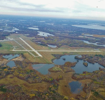
| BRAINERD LAKES RGNL BRAINERD MN |
| |
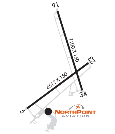
| Lat: N 4624.3 Long: W 09408.0 Elev: 1232 Var: -03 Longest Runway: 7100 | ||
| AWOS: 126.77 CTAF: 122.7 | ||
| ||||||||||||||||||||||||||||||||||||||||||||
| ||||||||||||||||||||||||||||||||||||||||||||
| ||||||||||||||||||||||||||||||||||||||||||||
| Rwy | Rwy | |||||||
| 6512x150 | 6512' | 6512x150 | 6512' | 109.90 - 230° | ||||
| 7100x150 | 7100' | 7100x150 | 7100' | 109.70 - 339° | ||||
| Runway ID | Single Wheel | Double Wheel | Double Tandem Wheel | Dual Double Wheel |
| 05/23 | 75,000 | 125,000 | 220,000 | N/A |
| 16/34 | 75,000 | 125,000 | 220,000 | N/A |
| H1 | N/A | N/A | N/A | N/A |
| These numbers are Advisory and are not limits. The Airport Manager should have more accurate Weight Limits | ||||
 Airport Diagram might not be current. | |
| Facility Name: | BRAINERD LAKES RGNL |
| City Name: | BRAINERD |
| County: | CROW WING |
| State abbrev: | MN |
| State Name: | MINNESOTA |
| Ownership: | PUBLICLY OWNED |
| Use: | OPEN TO THE PUBLIC |
| Owner's Name: | BRAINERD/CROW WING CNTY |
| Address: | 16384 AIRPORT RD, SUITE 5 |
| BRAINERD, MN 56401 | |
| Owner's Phone: | 218-825-2166 |
| Manager's Name: | STEVEN WRIGHT |
| Address: | BRAINERD LAKES REGIONAL ARPT, 16384 AIRPORT RD SUITE 5; EMAIL ADDRESS: STEVENWRIGHT@BRAINERDAIRPORT.COM (ALL LOWER CASE) |
| BRAINERD, MN 56401 | |
| Phone: | 218-825-2166 |
| FAA Region: | GREAT LAKES |
| FAA Field Office: | DMA |
| Date | Sunrise | Sunset |
|---|---|---|
| 09/24/21 Friday | 7:06 | 19:11 |
| 09/25/21 Saturday | 7:07 | 19:09 |
| 09/26/21 Sunday | 7:08 | 19:07 |
| 09/27/21 Monday | 7:10 | 19:05 |
| 09/28/21 Tuesday | 7:11 | 19:03 |
| 09/29/21 Wednesday | 7:12 | 19:01 |
| 09/30/21 Thursday | 7:13 | 18:59 |
| 10/01/21 Friday | 7:15 | 18:57 |
| 10/02/21 Saturday | 7:16 | 18:55 |
| 10/03/21 Sunday | 7:17 | 18:53 |
| 10/04/21 Monday | 7:19 | 18:51 |
| 10/05/21 Tuesday | 7:20 | 18:49 |
| 10/06/21 Wednesday | 7:21 | 18:47 |
| 10/07/21 Thursday | 7:23 | 18:45 |
| Airport Attendance Schedule | JUL-OCT 7 Days A Week 0500-2300, NOV-JUN 7 Days A Week 0500-2300 |
| Airport Status | OPERATIONAL (This Status can change at any time - please check NOTAMS) |
| Airport Lighting Schedule | HIRL RY 05/23 & HIRL RY 16/34 PRESET ON LOW INTST; TO INCR INTST & ACTVT REIL RYS 05 & 16 AND MALSR RY 23 & 34 - CTAF. |
| Airport Storage Available | Tie Downs, Hanger |
| Extra Services Available | Avionics, Charter, Flight Instruction, Aircraft Rental |
| Wind Indicator | YES - (lighted) |
| Control Tower | NO |
| CTAF Frequency | 122.700 |
| Unicom Frequency | 122.700 |
| Rotating Beacon Color | CLEAR-GREEN (Light Land Airport) |
| Segmented Circle | YES |
| Landing Fee | NO |
| Airport Inspected | FEDERAL - performed by FAA AIRPORTS FIELD PERSONNEL |
| Inspection Date | 10/08/2019 |
| Type of Fuel Available | Grade 100LL, JET A (freeze point -40C) |
| Airframe Repair Service | MAJOR |
| Power Plant Repair Service | MAJOR |
| Latitude | N4624.3 |
| Longitude | W09408.0 (ESTIMATED) |
| Arpt Elevation | 1232ft (SURVEYED) |
| Magnetic Variation | 03E |
| 3 miles NE | of BRAINERD |
| Traffic Pattern Altitude | |
| Sectional Chart | TWIN CITIES |
| Operations (Reported) | Yearly | Avg. Daily |
|---|---|---|
| General Aviation Transient | 14500 | 40 |
| General Aviation Local | 18500 | 51 |
| Air Taxi | 1400 | 4 |
| Commerical | 3100 | 8 |
| Commuter | 0 | 0 |
| Military | 400 | 1 |
| Aircraft based on Field | |
|---|---|
| General Aviation Singles | 69 |
| General Aviation Multi | 6 |
| Jet Aircraft | 6 |
| General Aviation Helicopters | 8 |
| Military Aircraft | 0 |
| Gliders | 0 |
| Ultralights | 0 |
| FSS on field | NO |
| FSS tie-in | PRINCETON |
| FSS Phone | 1-800-WX-BRIEF |
| Who issues Notams | BRD |
| Notam D service at airport | YES |
| ARTCC Name | MINNEAPOLIS |
| Airport Certification | AIRPORT RECEIVING SCHEDULED AIR CARRIER SERVICE FROM CARRIERS CERTIFICATED BY THE CIVIL AERONAUTICS BOARD |
| Aircraft Rescue & Firefighting Index | AIRPORT HAS A CERTIFICATE UNDER CFR PART 139 |
| Airport of Entry | No |
| Custom Landing Rights | No |
| Joint Civil/Military | No |
| Military Landing rights | YES |
| NATIONAL PLAN OF INTEGRATED AIRPORT SYSTEMS (NPIAS) |
| GRANT AGREEMENTS UNDER FAAP/ADAP/AIP |
| ASSURANCES PURSUANT TO TITLE VI, CIVIL RIGHTS ACT OF 1964 |
| DEER AND GULLS ON & INVOF ARPT. |
| FOR ATTENDANCE OTHER HRS, SEE CURRENT PHONE LISTING IN PILOTS LOUNGE, 218-829-3398. |
| PPR FOR UNSKED ACR OPNS WITH MORE THAN 30 PSGR SEATS CALL AMGR 218-825-2166 BTN 0800-1700. ACR OPNS INVOLVING ACFT WITH MORE THAN 30 PSGRS ARE NOT AUZD IN EXCESS OF 15 MINS BEFORE OR AFTER SKEDD ARR/DEP TIMES WITHOUT PRIOR COORDINATION WITH AMGR AND CFMN THAT ARFF IS AVBL PRIOR TO LNDG OR TKOF. |
| FOR CD IF UNA TO CTC ON FSS FREQ, CTC MINNEAPOLIS ARTCC AT 651-463-5588. |
Airport Communications & Frequencies:
| |||||||||
| Runway: 05 | Runway: 23 | ||
| Mag heading: | 51° | Mag heading: | 231° |
| Rwy Slope: | .04% Up | Rwy Slope: | -.04% Down |
| Approach: | Approach: | ILS | |
| Pattern: | Left Traffic | Pattern: | Left Traffic |
| Markings: | PRECISION INSTRUMENT | Markings: | PRECISION INSTRUMENT |
| Marking Condition: | GOOD | Marking Condition: | GOOD |
| Arresting Dev: | Arresting Dev: | ||
| Lat & Long: | N4623.7 W09408.8 | Lat. & Long.: | N4624.3 W09407.5 |
| Elev: | 1220.3 ft. MSL | Elev: | 1222.6 ft. MSL |
| TCH: | 45 ft. AGL | TCH: | 50 ft. AGL |
| Visual Glide Path: | 3.00 degrees | Visual Glide Path: | 3.00 degrees |
| Displaced Threshold: | No | Displaced Threshold: | No |
| Touchdown Zone: | YES | Touchdown Zone: | YES |
| Touchdown Elev.: | 1223.5 feet | Touchdown Elev.: | 1224.2 feet |
| Visual Glide Slope: | 4-BOX VASI ON LEFT SIDE OF RUNWAY | Visual Glide Slope: | 4-Light PAPI on LEFT side of Runway; PAPI UNSABLE BYD 9 DEG RIGHT OF COURSE. |
| RVR Equipment: | RVR Equipment: | ||
| RVV Equipment: | NO | RVV Equipment: | NO |
| Approach Lights: | Approach Lights: | MALSR - 1,400 foot medium intensity approach lighting system with runway alignment indicator lights | |
| REIL: | YES | REIL: | NO |
| Centerline Lights: | NO | Centerline Lights: | NO |
| Touchdown lights: | NO | Touchdown lights: | NO |
| Runway Category: | D | Runway Category: | Precision Instrument Runway |
| Declared Distances: | Declared Distances: | ||
| Obstructions: | TREE | Obstructions: | TREES |
| Marked: | NOT Marked/Lighted | Marked: | NOT Marked/Lighted |
| Clearance slope: | 37:1 | Clearance slope: | 38:1 |
| Obstruction height: | 79 feet AGL | Obstruction height: | 68 feet AGL |
| Dist. from runway: | 3174 feet | Dist. from runway: | 2803 feet |
| Centerline offset: | 561 left of centerline | Centerline offset: | 800 feet left of centerline |
| Comments: | Comments: |
| Runway: 16 | Runway: 34 | ||
| Mag heading: | 160° | Mag heading: | 340° |
| Rwy Slope: | .08% Up | Rwy Slope: | -.08% Down |
| Approach: | Approach: | ILS/DME | |
| Pattern: | Left Traffic | Pattern: | Left Traffic |
| Markings: | PRECISION INSTRUMENT | Markings: | PRECISION INSTRUMENT |
| Marking Condition: | GOOD | Marking Condition: | GOOD |
| Arresting Dev: | Arresting Dev: | ||
| Lat & Long: | N4625.0 W09408.2 | Lat. & Long.: | N4623.9 W09407.7 |
| Elev: | 1226.2 ft. MSL | Elev: | 1232.2 ft. MSL |
| TCH: | 45 ft. AGL | TCH: | 46 ft. AGL |
| Visual Glide Path: | 3.00 degrees | Visual Glide Path: | 3.00 degrees |
| Displaced Threshold: | No | Displaced Threshold: | No |
| Touchdown Zone: | YES | Touchdown Zone: | YES |
| Touchdown Elev.: | 1226.3 feet | Touchdown Elev.: | 1232.2 feet |
| Visual Glide Slope: | 4-Light PAPI on LEFT side of Runway | Visual Glide Slope: | 4-Light PAPI on RIGHT side of Runway |
| RVR Equipment: | RVR Equipment: | ||
| RVV Equipment: | NO | RVV Equipment: | NO |
| Approach Lights: | Approach Lights: | MALSR - 1,400 foot medium intensity approach lighting system with runway alignment indicator lights | |
| REIL: | YES | REIL: | NO |
| Centerline Lights: | NO | Centerline Lights: | NO |
| Touchdown lights: | NO | Touchdown lights: | NO |
| Runway Category: | Runway with a Visual Approach | Runway Category: | Precision Instrument Runway |
| Declared Distances: | Declared Distances: |
Thanks for using FltPlan.com
all rights reserved © 1999-2021 by Flight Plan LLC