
| MOREHOUSE MEMORIAL BASTROP LA |
| |
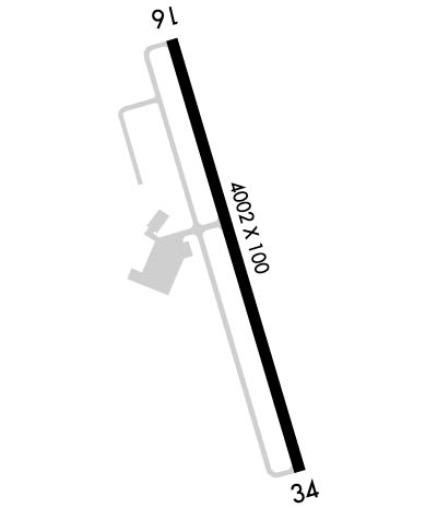
| Lat: N 3245.4 Long: W 09152.8 Elev: 168 Var: -03 Longest Runway: 4002 | ||
| Clr Del: 135.07 GCO AWOS: 118.37 CTAF: 122.8 | ||
| ||||||
| ||||||
|
| Rwy | Rwy | |||||||
| 4002x100 | 4002' | 4002x100 | 4002' | |||||
| Runway ID | Single Wheel | Double Wheel | Double Tandem Wheel | Dual Double Wheel |
| 16/34 | 15,500 | N/A | N/A | N/A |
| These numbers are Advisory and are not limits. The Airport Manager should have more accurate Weight Limits | ||||
 Airport Diagram might not be current. | |
| Facility Name: | MOREHOUSE MEML |
| City Name: | BASTROP |
| County: | MOREHOUSE |
| State abbrev: | LA |
| State Name: | LOUISIANA |
| Ownership: | PUBLICLY OWNED |
| Use: | OPEN TO THE PUBLIC |
| Owner's Name: | CITY OF BASTROP |
| Address: | PO BOX 431 |
| BASTROP, LA 71221 | |
| Owner's Phone: | 318-283-0250 |
| Manager's Name: | BRENT ELTON |
| Address: | 6336 HOLLAND DRIVE |
| BASTROP, LA 71220 | |
| Phone: | 318-281-2018 |
| FAA Region: | SOUTHWEST |
| FAA Field Office: | LNM |
| Date | Sunrise | Sunset |
|---|---|---|
| 09/24/21 Friday | 6:57 | 19:02 |
| 09/25/21 Saturday | 6:57 | 19:00 |
| 09/26/21 Sunday | 6:58 | 18:59 |
| 09/27/21 Monday | 6:59 | 18:58 |
| 09/28/21 Tuesday | 6:59 | 18:56 |
| 09/29/21 Wednesday | 7:00 | 18:55 |
| 09/30/21 Thursday | 7:01 | 18:54 |
| 10/01/21 Friday | 7:01 | 18:52 |
| 10/02/21 Saturday | 7:02 | 18:51 |
| 10/03/21 Sunday | 7:03 | 18:50 |
| 10/04/21 Monday | 7:04 | 18:48 |
| 10/05/21 Tuesday | 7:04 | 18:47 |
| 10/06/21 Wednesday | 7:05 | 18:46 |
| 10/07/21 Thursday | 7:06 | 18:45 |
| Airport Attendance Schedule | MON-FRI 0715-1500 |
| Airport Status | OPERATIONAL (This Status can change at any time - please check NOTAMS) |
| Airport Lighting Schedule | DUSK-DAWN. MIRL RY 16/34, REIL RYS 16 & 34 PRESET LOW INTST DUSK-DAWN; TO INCR INTST ACTVT - CTAF. |
| Airport Storage Available | Tie Downs |
| Extra Services Available | NONE |
| Wind Indicator | YES - (lighted) |
| Control Tower | NO |
| CTAF Frequency | 122.800 |
| Unicom Frequency | 122.800 |
| Rotating Beacon Color | CLEAR-GREEN (Light Land Airport) |
| Segmented Circle | NO |
| Landing Fee | NO |
| Airport Inspected | STATE - performed by STATE AERONAUTICAL PERSONNEL |
| Inspection Date | 10/15/2020 |
| Type of Fuel Available | Grade 100LL; -10SELF SERVE FUEL AVBL 24 HRS WITH CREDIT CARD. |
| Airframe Repair Service | MINOR |
| Power Plant Repair Service | MINOR |
| Latitude | N3245.4 |
| Longitude | W09152.8 (ESTIMATED) |
| Arpt Elevation | 167ft (SURVEYED) |
| Magnetic Variation | 03E |
| 2 miles SE | of BASTROP |
| Traffic Pattern Altitude | 1033 |
| Sectional Chart | MEMPHIS |
| Operations (Reported) | Yearly | Avg. Daily |
|---|---|---|
| General Aviation Transient | 10000 | 27 |
| General Aviation Local | 20000 | 55 |
| Air Taxi | 0 | 0 |
| Commerical | 0 | 0 |
| Commuter | 0 | 0 |
| Military | 200 | 1 |
| Aircraft based on Field | |
|---|---|
| General Aviation Singles | 10 |
| General Aviation Multi | 2 |
| Jet Aircraft | 0 |
| General Aviation Helicopters | 0 |
| Military Aircraft | 0 |
| Gliders | 0 |
| Ultralights | 0 |
| FSS on field | NO |
| FSS tie-in | DE RIDDER |
| FSS Phone | 1-800-WX-BRIEF |
| Who issues Notams | DRI |
| Notam D service at airport | YES |
| ARTCC Name | FORT WORTH |
| Airport Certification | |
| Aircraft Rescue & Firefighting Index | None |
| Airport of Entry | No |
| Custom Landing Rights | No |
| Joint Civil/Military | No |
| Military Landing rights | No |
| NATIONAL PLAN OF INTEGRATED AIRPORT SYSTEMS (NPIAS) |
| GRANT AGREEMENTS UNDER FAAP/ADAP/AIP |
| ASSURANCES PURSUANT TO TITLE VI, CIVIL RIGHTS ACT OF 1964 |
| DEER ON & INVOF RY. |
| FOR CD CTC MONROE APCH AT 318-327-5641, IF UNAVBL, CTC FORT WORTH ARTCC AT 817-858-7584. |
Airport Communications & Frequencies:
| |||||||||||||||||
| Runway: 16 | Runway: 34 | ||
| Mag heading: | 161° | Mag heading: | 341° |
| Rwy Slope: | .09% Up | Rwy Slope: | -.09% Down |
| Approach: | Approach: | ||
| Pattern: | Left Traffic | Pattern: | Left Traffic |
| Markings: | NONPRECISION INSTRUMENT | Markings: | NONPRECISION INSTRUMENT |
| Marking Condition: | POOR; RWY MARKINGS IN POOR COND DUE TO FADING AND MOLD GROWTH. | Marking Condition: | FAIR |
| Arresting Dev: | Arresting Dev: | ||
| Lat & Long: | N3245.7 W09152.9 | Lat. & Long.: | N3245.0 W09152.7 |
| Elev: | 158.8 ft. MSL | Elev: | 162.3 ft. MSL |
| TCH: | 50 ft. AGL | TCH: | 50 ft. AGL |
| Visual Glide Path: | 3.00 degrees | Visual Glide Path: | 3.00 degrees |
| Displaced Threshold: | No | Displaced Threshold: | No |
| Touchdown Zone: | YES | Touchdown Zone: | YES |
| Touchdown Elev.: | 167.7 feet | Touchdown Elev.: | 167.7 feet |
| Visual Glide Slope: | 2-Light PAPI on LEFT side of Runway; PAPI OTS INDEFLY. | Visual Glide Slope: | 2-Light PAPI on LEFT side of Runway |
| RVR Equipment: | RVR Equipment: | ||
| RVV Equipment: | NO | RVV Equipment: | NO |
| Approach Lights: | Approach Lights: | ||
| REIL: | YES | REIL: | YES; RY 34 REIL OTS INDEFLY. |
| Centerline Lights: | NO | Centerline Lights: | NO |
| Touchdown lights: | NO | Touchdown lights: | NO |
| Runway Category: | Runway with a Non-precision Approach | Runway Category: | Runway with a Non-precision Approach |
| Declared Distances: | Declared Distances: |
Thanks for using FltPlan.com
all rights reserved © 1999-2021 by Flight Plan LLC
