
| BAXTER COUNTY AP MOUNTAIN HOME AR |
| |
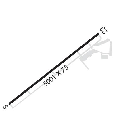
| Lat: N 3622.1 Long: W 09228.2 Elev: 928 Var: -03 Longest Runway: 5000 | ||
| AWOS: 133.97 CTAF: 123.0 | ||
| ||||||
| ||||||
|
| Rwy | Rwy | |||||||
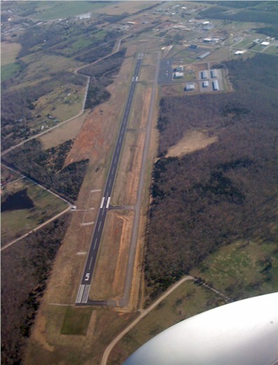
| 5000x75 | 5000' | 111.95 - 049° | 5000x75 | 5000' | ||||
| Runway ID | Single Wheel | Double Wheel | Double Tandem Wheel | Dual Double Wheel |
| 05/23 | 17,000 | N/A | N/A | N/A |
| These numbers are Advisory and are not limits. The Airport Manager should have more accurate Weight Limits | ||||
 Airport Diagram might not be current. | |
| Facility Name: | BAXTER COUNTY |
| City Name: | MOUNTAIN HOME |
| County: | BAXTER |
| State abbrev: | AR |
| State Name: | ARKANSAS |
| Ownership: | PUBLICLY OWNED |
| Use: | OPEN TO THE PUBLIC |
| Owner's Name: | BAXTER COUNTY |
| Address: | CTY COURTHOUSE 1 E 7TH ST STE 303 |
| MOUNTAIN HOME, AR 72653 | |
| Owner's Phone: | 870-425-2755 |
| Manager's Name: | PAUL FAGRAS |
| Address: | 6462 HWY 126 NORTH |
| MIDWAY, AR 72651 | |
| Phone: | 870-481-5418 |
| FAA Region: | SOUTHWEST |
| FAA Field Office: | AOK |
| Date | Sunrise | Sunset |
|---|---|---|
| 09/24/21 Friday | 6:59 | 19:04 |
| 09/25/21 Saturday | 7:00 | 19:03 |
| 09/26/21 Sunday | 7:01 | 19:01 |
| 09/27/21 Monday | 7:02 | 19:00 |
| 09/28/21 Tuesday | 7:02 | 18:58 |
| 09/29/21 Wednesday | 7:03 | 18:57 |
| 09/30/21 Thursday | 7:04 | 18:55 |
| 10/01/21 Friday | 7:05 | 18:54 |
| 10/02/21 Saturday | 7:06 | 18:52 |
| 10/03/21 Sunday | 7:06 | 18:51 |
| 10/04/21 Monday | 7:07 | 18:49 |
| 10/05/21 Tuesday | 7:08 | 18:48 |
| 10/06/21 Wednesday | 7:09 | 18:46 |
| 10/07/21 Thursday | 7:10 | 18:45 |
| Airport Attendance Schedule | MON-FRI 0700-1700; FOR SVC AFT HRS CALL 870-402-9000 OR 870-405-8000. |
| Airport Status | OPERATIONAL (This Status can change at any time - please check NOTAMS) |
| Airport Lighting Schedule | ACTVT REIL RWY 05 & 23; PAPI RWY 05 & 23; MIRL 05/23 - CTAF. |
| Airport Storage Available | Tie Downs, Hanger |
| Extra Services Available | Flight Instruction, Aircraft Rental, Aircraft Sales |
| Wind Indicator | YES - (lighted) |
| Control Tower | NO |
| CTAF Frequency | 123.000 |
| Unicom Frequency | 123.000 |
| Rotating Beacon Color | CLEAR-GREEN (Light Land Airport) |
| Segmented Circle | YES |
| Landing Fee | NO |
| Airport Inspected | STATE - performed by STATE AERONAUTICAL PERSONNEL |
| Inspection Date | 08/18/2020 |
| Type of Fuel Available | Grade 100LL, JET A (freeze point -40C) |
| Airframe Repair Service | MAJOR |
| Power Plant Repair Service | MAJOR |
| Latitude | N3622.1 |
| Longitude | W09228.2 (ESTIMATED) |
| Arpt Elevation | 928ft (SURVEYED) |
| Magnetic Variation | 03E |
| 4 miles NW | of MOUNTAIN HOME |
| Traffic Pattern Altitude | |
| Sectional Chart | KANSAS CITY |
| Operations (Reported) | Yearly | Avg. Daily |
|---|---|---|
| General Aviation Transient | 3000 | 8 |
| General Aviation Local | 7500 | 21 |
| Air Taxi | 300 | 1 |
| Commerical | 0 | 0 |
| Commuter | 0 | 0 |
| Military | 700 | 2 |
| Aircraft based on Field | |
|---|---|
| General Aviation Singles | 41 |
| General Aviation Multi | 7 |
| Jet Aircraft | 6 |
| General Aviation Helicopters | 0 |
| Military Aircraft | 0 |
| Gliders | 0 |
| Ultralights | 0 |
| FSS on field | NO |
| FSS tie-in | JONESBORO |
| FSS Phone | 1-800-WX-BRIEF |
| Who issues Notams | BPK |
| Notam D service at airport | YES |
| ARTCC Name | MEMPHIS |
| Airport Certification | NO SERVICE AVBL UFN. |
| Aircraft Rescue & Firefighting Index | None |
| Airport of Entry | No |
| Custom Landing Rights | No |
| Joint Civil/Military | No |
| Military Landing rights | YES |
| NATIONAL PLAN OF INTEGRATED AIRPORT SYSTEMS (NPIAS) |
| GRANT AGREEMENTS UNDER FAAP/ADAP/AIP |
| ASSURANCES PURSUANT TO TITLE VI, CIVIL RIGHTS ACT OF 1964 |
| GCO AVBL ON FREQ 121.72, MEMPHIS (ZME) CD ON 4 CLICKS, FSS WX BRIEF 6 CLICKS. |
| FBO ON 870-402-9000. |
| FOR CD IF UNA VIA GCO CTC MEMPHIS ARTCC AT 901-368-8453/8449. |
Airport Communications & Frequencies:
| |||||||||
| Runway: 05 | Runway: 23 | ||
| Mag heading: | 49° | Mag heading: | 229° |
| Rwy Slope: | -.33% Down | Rwy Slope: | .33% Up |
| Approach: | ILS/DME | Approach: | |
| Pattern: | Left Traffic | Pattern: | Left Traffic |
| Markings: | NONPRECISION INSTRUMENT | Markings: | NONPRECISION INSTRUMENT |
| Marking Condition: | POOR; RWY 05 MARKINGS FADED | Marking Condition: | POOR; RWY 23 MARKINGS FADED |
| Arresting Dev: | Arresting Dev: | ||
| Lat & Long: | N3621.9 W09228.6 | Lat. & Long.: | N3622.4 W09227.8 |
| Elev: | 928.0 ft. MSL | Elev: | 911.7 ft. MSL |
| TCH: | 38 ft. AGL | TCH: | 46 ft. AGL |
| Visual Glide Path: | 3.00 degrees | Visual Glide Path: | 4.00 degrees |
| Displaced Threshold: | No | Displaced Threshold: | No |
| Touchdown Zone: | YES | Touchdown Zone: | YES |
| Touchdown Elev.: | 928.0 feet | Touchdown Elev.: | 918.9 feet |
| Visual Glide Slope: | 4-Light PAPI on RIGHT side of Runway | Visual Glide Slope: | 2-Light PAPI on LEFT side of Runway |
| RVR Equipment: | RVR Equipment: | ||
| RVV Equipment: | NO | RVV Equipment: | NO |
| Approach Lights: | Approach Lights: | ||
| REIL: | YES | REIL: | YES |
| Centerline Lights: | NO | Centerline Lights: | NO |
| Touchdown lights: | NO | Touchdown lights: | NO |
| Runway Category: | Precision Instrument Runway | Runway Category: | Runway with a Non-precision Approach having visibility minimums greater than 3/4 mile |
| Declared Distances: | Declared Distances: | ||
| Obstructions: | ROAD | Obstructions: | PLINE |
| Marked: | NOT Marked/Lighted | Marked: | NOT Marked/Lighted |
| Clearance slope: | 26:1 | Clearance slope: | 20:1 |
| Obstruction height: | 19 feet AGL | Obstruction height: | 55 feet AGL |
| Dist. from runway: | 701 feet | Dist. from runway: | 1300 feet |
| Centerline offset: | Centerline offset: | 300 feet right of centerline | |
| Comments: | GND GRADUALLY RISES AWAY FM RY APRXLY 3' WITHIN CLOSE-IN AREA. | Comments: |
Thanks for using FltPlan.com
all rights reserved © 1999-2021 by Flight Plan LLC