
| BIG SPRING MC MAHON-WRINKLE BIG SPRING TX |
| |
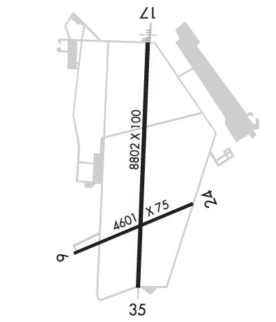
| Lat: N 3212.8 Long: W 10131.3 Elev: 2573 Var: -07 Longest Runway: 8803 | ||
| AWOS: 118.02 CTAF: 122.8 | ||
| |||||||||||||||||||||||||||||||
| |||||||||||||||||||||||||||||||
| |||||||||||||||||||||||||||||||
| Rwy | Rwy | |||||||
| 4601x75 | 4601' | 4601x75 | 4601' | |||||
| 8803x100 | 8803' | 8803x100 | 8803' | |||||
| Runway ID | Single Wheel | Double Wheel | Double Tandem Wheel | Dual Double Wheel |
| 06/24 | N/A | N/A | N/A | N/A |
| 17/35 | 60,000 | 150,000 | 200,000 | N/A |
| These numbers are Advisory and are not limits. The Airport Manager should have more accurate Weight Limits | ||||
 Airport Diagram might not be current. | |
| Facility Name: | BIG SPRING/MC MAHON-WRINKLE |
| City Name: | BIG SPRING |
| County: | HOWARD |
| State abbrev: | TX |
| State Name: | TEXAS |
| Ownership: | PUBLICLY OWNED |
| Use: | OPEN TO THE PUBLIC |
| Owner's Name: | CITY OF BIG SPRING |
| Address: | 310 NOLAN |
| BIG SPRING, TX 79720 | |
| Owner's Phone: | 432-264-2400 |
| Manager's Name: | MICHAEL FEELEY |
| Address: | 3200 RICKABAUGH DRIVE WEST |
| BIG SPRING, TX 79720 | |
| Phone: | 432-264-2362; MGR CELL 432-466-3385. |
| FAA Region: | SOUTHWEST |
| FAA Field Office: | TEX |
| Date | Sunrise | Sunset |
|---|---|---|
| 06/08/26 Monday | 6:39 | 20:51 |
| 06/09/26 Tuesday | 6:39 | 20:52 |
| 06/10/26 Wednesday | 6:39 | 20:52 |
| 06/11/26 Thursday | 6:39 | 20:53 |
| 06/12/26 Friday | 6:39 | 20:53 |
| 06/13/26 Saturday | 6:39 | 20:53 |
| 06/14/26 Sunday | 6:39 | 20:54 |
| 06/15/26 Monday | 6:39 | 20:54 |
| 06/16/26 Tuesday | 6:39 | 20:54 |
| 06/17/26 Wednesday | 6:39 | 20:55 |
| 06/18/26 Thursday | 6:39 | 20:55 |
| 06/19/26 Friday | 6:39 | 20:55 |
| 06/20/26 Saturday | 6:40 | 20:56 |
| 06/21/26 Sunday | 6:40 | 20:56 |
| Airport Attendance Schedule | MON-FRI 0800-1700 |
| Airport Status | OPERATIONAL (This Status can change at any time - please check NOTAMS) |
| Airport Lighting Schedule | MIRL RWYS 06/24 & 17/35 PRESET LOW INTST; TO INCR INTST & ACTVT SSALS RWY 17 - CTAF. |
| Airport Storage Available | Tie Downs, Hanger |
| Extra Services Available | Crop Dusting, Flight Instruction |
| Wind Indicator | YES - (lighted) |
| Control Tower | NO |
| CTAF Frequency | 122.800 |
| Unicom Frequency | 122.800 |
| Rotating Beacon Color | WG |
| Segmented Circle | YES |
| Landing Fee | NO |
| Airport Inspected | STATE - performed by PRIVATE CONTRACT PERSONNEL |
| Inspection Date | 04/21/2024 |
| Type of Fuel Available | Grade 100LL, JET A (freeze point -40C) |
| Airframe Repair Service | MAJOR |
| Power Plant Repair Service | MAJOR |
| Latitude | N3212.8 |
| Longitude | W10131.3 (ESTIMATED) |
| Arpt Elevation | 2572ft (SURVEYED) |
| Magnetic Variation | 07E |
| 2 miles SW | of BIG SPRING |
| Traffic Pattern Altitude | |
| Sectional Chart | DALLAS-FT WORTH |
| Operations (Reported) | Yearly | Avg. Daily |
|---|---|---|
| General Aviation Transient | 0 | 0 |
| General Aviation Local | 0 | 0 |
| Air Taxi | 0 | 0 |
| Commerical | 0 | 0 |
| Commuter | 0 | 0 |
| Military | 0 | 0 |
| Aircraft based on Field | |
|---|---|
| General Aviation Singles | 0 |
| General Aviation Multi | 0 |
| Jet Aircraft | 0 |
| General Aviation Helicopters | 0 |
| Military Aircraft | 0 |
| Gliders | 0 |
| Ultralights | 0 |
| FSS on field | NO |
| FSS tie-in | SAN ANGELO |
| FSS Phone | 1-800-WX-BRIEF |
| Who issues Notams | BPG |
| Notam D service at airport | YES |
| ARTCC Name | FORT WORTH |
| Airport Certification | |
| Aircraft Rescue & Firefighting Index | None |
| Airport of Entry | No |
| Custom Landing Rights | No |
| Joint Civil/Military | No |
| Military Landing rights | YES |
| NATIONAL PLAN OF INTEGRATED AIRPORT SYSTEMS (NPIAS) |
| SURPLUS PROPERTY AGREEMENT UNDER PUBLIC LAW 289 |
| ASSURANCES PURSUANT TO TITLE VI, CIVIL RIGHTS ACT OF 1964 |
| GRANT AGREEMENT HAS EXPIRED; HOWEVER, AGREEMENT REMAINS IN EFFECT FOR THIS FACILITY AS LONG AS IT IS PUBLIC USE. |
| AGREEMENT UNDER DLAND OR DCLA HAS EXPIRED. |
| FBO 432-264-7124. AFT HRS 432-935-1238. |
| SANDHILL CRANES XNG IN THE SPRING & FALL. |
| PRAIRIE DOGS ON RWYS & TWYS. |
| FOR CD CTC FORT WORTH ARTCC AT 817-858-7584. |
| 100 LL & JET-A FULL & SELF SERVE. |
Airport Communications & Frequencies:
| |||||||||
| Runway: 06 | Runway: 24 | ||
| Mag heading: | 60° | Mag heading: | 240° |
| Rwy Slope: | .56% Up | Rwy Slope: | -.56% Down |
| Approach: | Approach: | ||
| Pattern: | Right Traffic | Pattern: | Left Traffic |
| Markings: | NONPRECISION INSTRUMENT | Markings: | NONPRECISION INSTRUMENT |
| Marking Condition: | FAIR | Marking Condition: | FAIR |
| Arresting Dev: | Arresting Dev: | ||
| Lat & Long: | N3212.4 W10131.7 | Lat. & Long.: | N3212.7 W10130.9 |
| Elev: | 2547.0 ft. MSL | Elev: | 2572.8 ft. MSL |
| TCH: | 40 ft. AGL | TCH: | 40 ft. AGL |
| Visual Glide Path: | 3.00 degrees | Visual Glide Path: | 3.00 degrees |
| Displaced Threshold: | No | Displaced Threshold: | No |
| Touchdown Zone: | YES | Touchdown Zone: | YES |
| Touchdown Elev.: | 2562.9 feet | Touchdown Elev.: | 2572.8 feet |
| Visual Glide Slope: | 2-Light PAPI on LEFT side of Runway | Visual Glide Slope: | 2-Light PAPI on LEFT side of Runway |
| RVR Equipment: | RVR Equipment: | ||
| RVV Equipment: | NO | RVV Equipment: | NO |
| Approach Lights: | Approach Lights: | ||
| REIL: | NO | REIL: | NO |
| Centerline Lights: | NO | Centerline Lights: | NO |
| Touchdown lights: | NO | Touchdown lights: | NO |
| Runway Category: | D | Runway Category: | D |
| Declared Distances: | Declared Distances: | ||
| Obstructions: | Obstructions: | FENCE | |
| Marked: | Marked: | NOT Marked/Lighted | |
| Clearance slope: | 50:1 | Clearance slope: | |
| Obstruction height: | Obstruction height: | 5 feet AGL | |
| Dist. from runway: | Dist. from runway: | 200 feet | |
| Centerline offset: | Centerline offset: | 332 feet left of centerline | |
| Comments: | Comments: |
| Runway: 17 | Runway: 35 | ||
| Mag heading: | 175° | Mag heading: | 355° |
| Rwy Slope: | .14% Up | Rwy Slope: | -.14% Down |
| Approach: | Approach: | ||
| Pattern: | Right Traffic | Pattern: | Left Traffic |
| Markings: | NONPRECISION INSTRUMENT | Markings: | NONPRECISION INSTRUMENT |
| Marking Condition: | FAIR | Marking Condition: | FAIR |
| Arresting Dev: | Arresting Dev: | ||
| Lat & Long: | N3213.6 W10131.3 | Lat. & Long.: | N3212.2 W10131.3 |
| Elev: | 2549.9 ft. MSL | Elev: | 2561.8 ft. MSL |
| TCH: | 45 ft. AGL | TCH: | 36 ft. AGL |
| Visual Glide Path: | 3.00 degrees | Visual Glide Path: | 3.00 degrees |
| Displaced Threshold: | No | Displaced Threshold: | No |
| Touchdown Zone: | YES | Touchdown Zone: | YES |
| Touchdown Elev.: | 2562.2 feet | Touchdown Elev.: | 2562.5 feet |
| Visual Glide Slope: | 4-Light PAPI on LEFT side of Runway | Visual Glide Slope: | 4-Light PAPI on LEFT side of Runway |
| RVR Equipment: | RVR Equipment: | ||
| RVV Equipment: | NO | RVV Equipment: | NO |
| Approach Lights: | SSALS - simplified short approach lighting system | Approach Lights: | |
| REIL: | NO | REIL: | NO |
| Centerline Lights: | NO | Centerline Lights: | NO |
| Touchdown lights: | NO | Touchdown lights: | NO |
| Runway Category: | D | Runway Category: | Runway with a Non-precision Approach having visibility minimums greater than 3/4 mile |
| Declared Distances: | Declared Distances: |
Thanks for using FltPlan.com
all rights reserved © 1999-2026 by Flight Plan LLC


